Egyptian Conquest Topographical Name List Maps: 1450 - 1279 BC
|
|
||
|
|
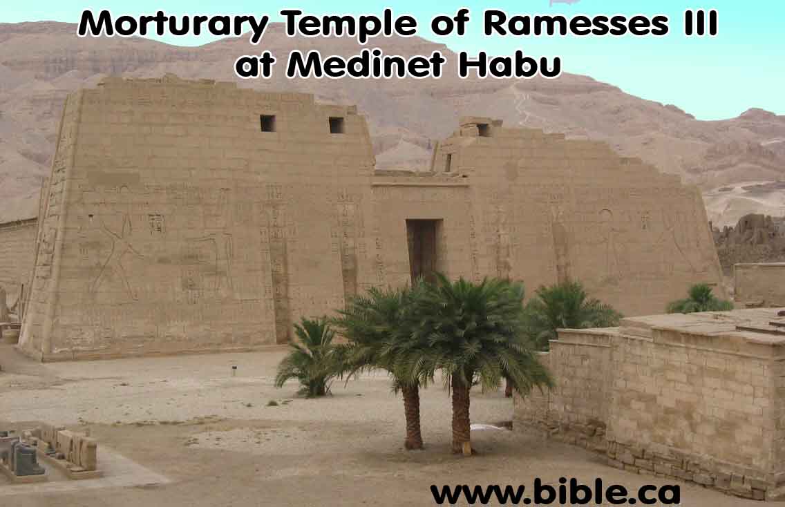
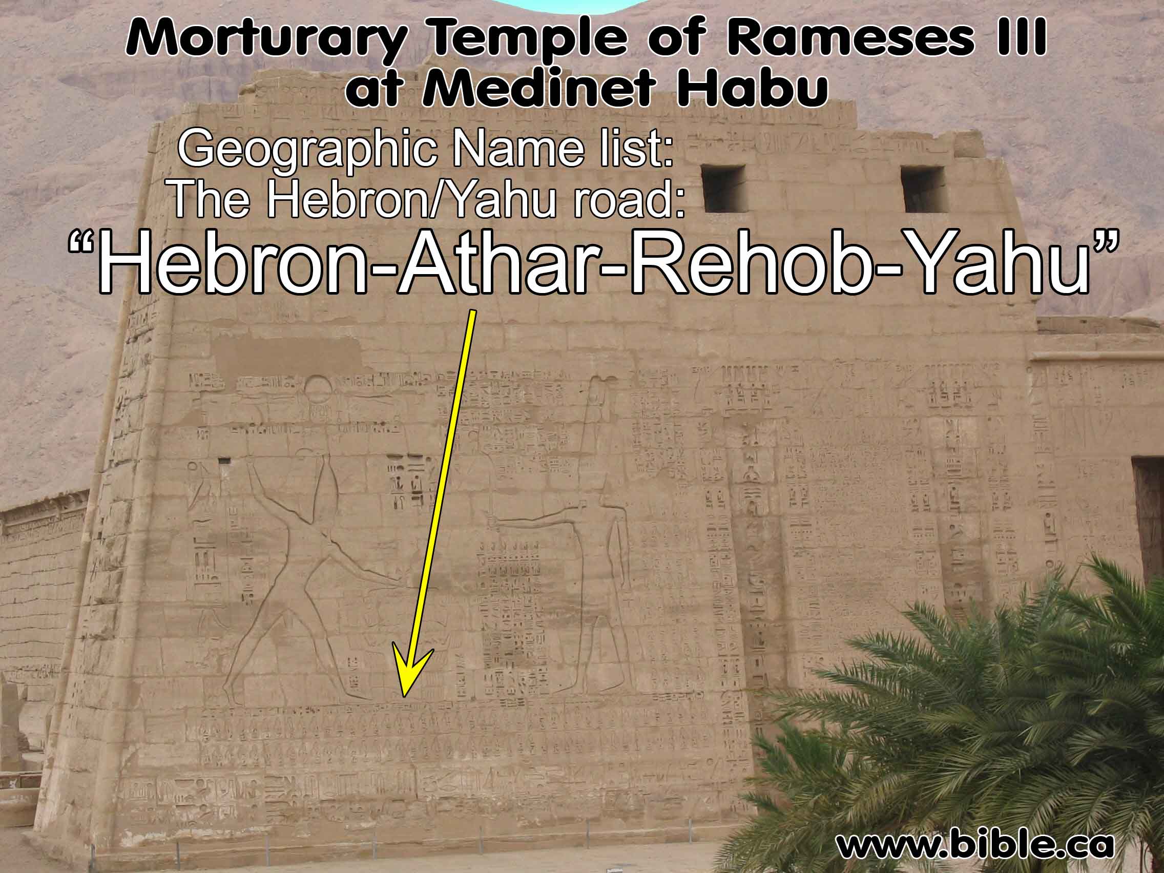
Topographical Lists Four Egyptian name/city topographical lists that perfectly confirm the exodus route and the conquest! 1. Thutmoses III List: Amon Temple at Karnak (1450 BC) 2. Amenophis III list: Temple in Soleb Nubia at ʿAmarah West (1387-1350 BC) 3. Ramesses II List: Amon Temple at Karnak (1279-1212 BC) 4. Ramesses III topographical list at Medinet Habu (1182-1151 BC) The Hebron/Yahu road: Hebron-Athar-Rehob-Yahu |
|
|
Archaeologists are digging up bible stories!!! |
||
|
Archaeology is an important science that confirms the historical accuracy of the Bible. Since the Bible refers to hundreds of cities, kings, and places, we would expect to find evidence from on-site excavations. And this is exactly what we have found. The Bible is the most historically accurate book of history on earth. Read the Bible daily! |
|
|

Introduction:
1. Egyptian Map "Name Lists" confirm the route of the Conquest of Numbers 33 and Joshua 15
a. Thutmoses III List: Amon Temple at Karnak (1450 BC)
b. Amenophis III list: Temple in Soleb Nubia at ʿAmarah West (1387-1350 BC)
c. Ramesses II List: Amon Temple at Karnak (1279-1212 BC)
d. Ramesses III topographical list at Medinet Habu (1182-1151 BC) The Hebron/Yahu road: Hebron-Athar-Rehob-Yahu
2. The Bible's Exodus itinerary is actually confirmed by Egyptian inscriptions and other Evidence.
a. Of the 12 of the 15 places referenced in three different Egyptian Sources are found in the Bible in the same exact order of travel.
b. We can even verify 10 of the 15 these places through archeology.
c. This creates a kind of map out of the name lists on the walls of various Egyptian name lists.
3. The Bible passages that mention cities also found in the 4 Egyptian sources:
a. “In the hill country: … Arab and Dumah and Eshan, and Janum and Beth-tappuah and Aphekah, and Humtah and Kiriath-arba (that is, Hebron), and Zior” (Joshua 15:53-54)
b. “Then Joshua and all Israel with him went up from Eglon to Hebron, and they fought against it.” (Joshua 10:36)
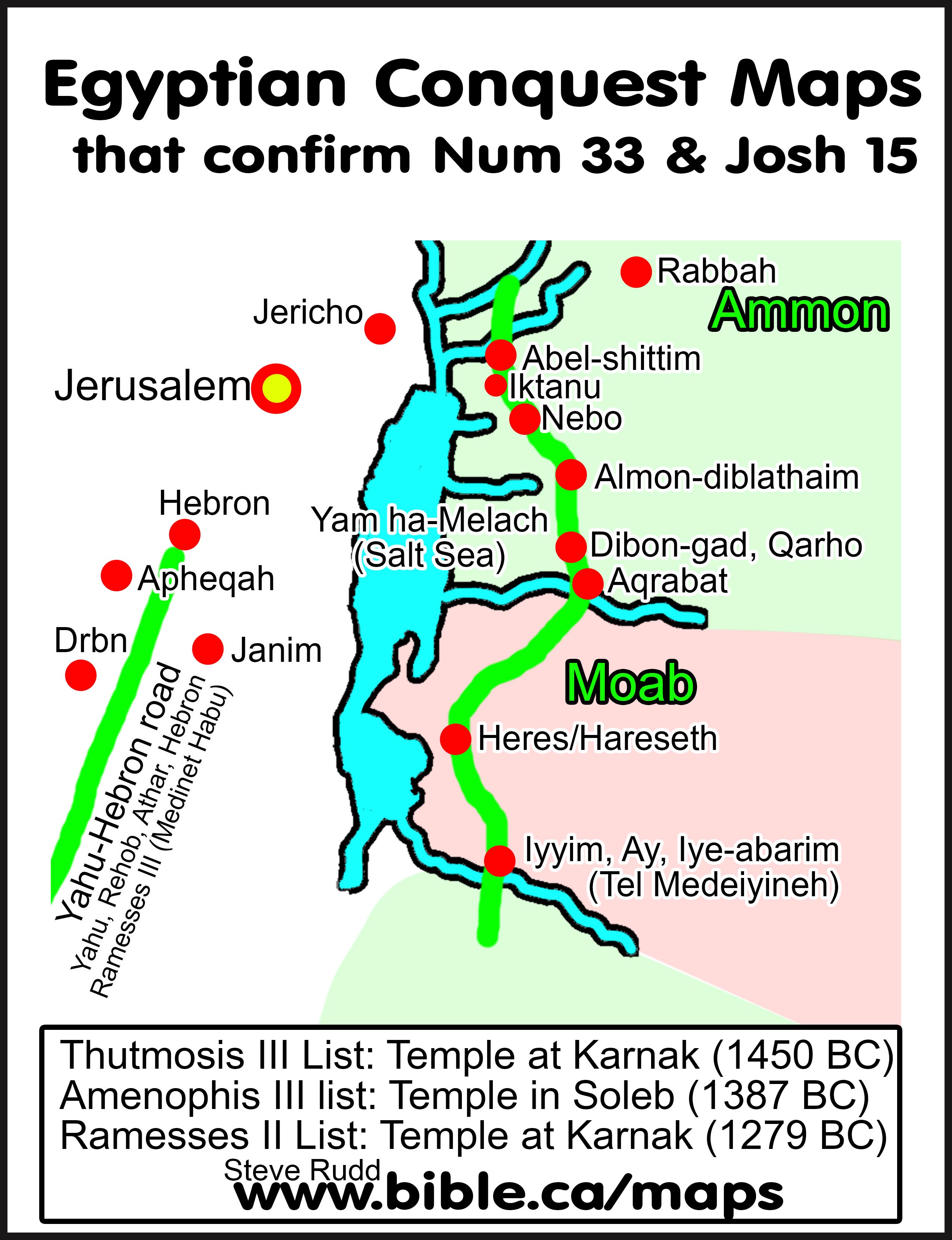
c. “They journeyed from Iyim and camped at Dibon-gad. They journeyed from Dibon-gad and camped at Almon-diblathaim. They journeyed from Almon-diblathaim and camped in the mountains of Abarim, before Nebo. They journeyed from the mountains of Abarim and camped in the plains of Moab by the Jordan opposite Jericho. They camped by the Jordan, from Beth-jeshimoth as far as Abel-shittim in the plains of Moab. Then the Lord spoke to Moses in the plains of Moab by the Jordan opposite Jericho, saying,” (Numbers 33:45–50)
I. Master summary table:
|
Bible |
Thutmoses
III List |
Amenophis
III list |
Ramesses II List |
Archeology Modern
name, |
|
Melah (Salt Sea) |
- |
(Yamm) ha-Melach |
- |
Yam ha-Melach |
|
Iyim, Iye-abarim: Num 33:44 (border of Moab) |
Iyyin |
- |
- |
Medeiyineh |
|
Heres/Hareseth |
- |
Hareseth |
Heres |
Kerak |
|
- |
- |
Aqrabat |
- |
al-Aqraba |
|
Dibon-gad: Num 33 |
Dibon |
- |
Qarho (Dibon) |
Dhiban |
|
Almon-diblathaim: Num 33 |
- |
- |
- |
- |
|
Nebo: Num 33 |
- |
- |
- |
- |
|
- |
- |
- |
Iktanu |
Tell Iktanu |
|
Abel-shittim: Num 33 |
Abel |
- |
Abel |
Tell Hammam |
|
Jordan: Num 33 |
Jordan |
- |
- |
Jordan River |
|
Hebron: Joshua 15:54 |
- |
- |
Hebron |
Hebron |
|
Janim: Josh 15:53 |
- |
- |
Janim |
- |
|
- |
- |
- |
Drbn |
- |
|
Aphekah: Josh 13:53 |
- |
- |
Apheqah |
Kh. Marajim |
|
King Jabin Judg 4-5 |
- |
- |
King Jabin |
- |
II. Photo gallery of geographic name lists:
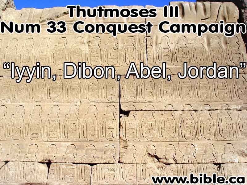
1. Thutmoses III topographical List (1450 BC) and Ramesses II List (1279-1212 BC): Amon Temple at Karnak:
a. The earliest (oldest) of the three maps comes from the reign of Thutmoses III (c. 1504–1450 B.C.E.), inscribed in the temple of Amon at Karnak as part of the so-called “Palestine List.” This is the greatest of the Egyptian topographical lists, containing 119 place-names associated with numerous routes in Palestine, Transjordan, Lebanon and Syria. The route of the Arabah to the Plains of Moab names, in order from south to north, four stations: Iyyin-Dibon-Abel-Jordan. It is not difficult to recognize this route in Numbers 33:45b–50. (Exodus Itinerary Confirmed by Egyptian Evidence, Charles R. Krahmalkov, BAR 20:05, Sep/Oct 1994 AD)
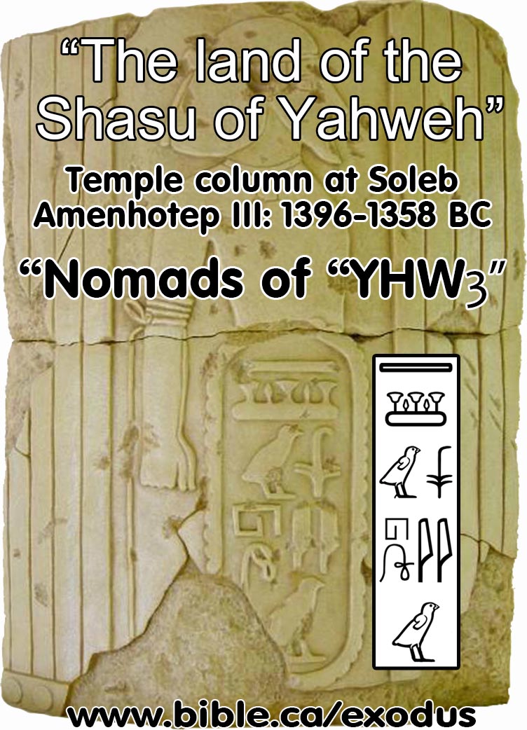
2. Amenophis III topographical list: Temple in Soleb Nubia at ʿAmarah West (1387-1350 BC)
a. "The second map dates to the reign of Amenophis III (c. 1387–1350 B.C.E.) and is inscribed in his mortuary temple at Soleb. It contains three stations listed in north-south direction: Aqrabat-Hareseth-Melach (the latter means Salt and refers to the Salt Sea, or the Dead Sea)." (Exodus Itinerary Confirmed by Egyptian Evidence, Charles R. Krahmalkov, BAR 20:05, Sep/Oct 1994 AD)
b. "Sets of Names inscribed around Lower Parts of Columns & Door-passages. This is most prominent in the runs of names around columns in the main hypostyle hall of the vast temple of Amenophis III at Soleb in Nubia. In Upper-Egyptian Abydos, two short lists (engraved as if on royal sphinx-bases) adorn the door-thicknesses of the King’s chapel of the Temple of Sethos I." (Egyptian New-Kingdom Topographical Lists, K.A. Kitchen, University of Liverpool)
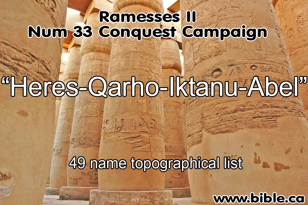
3. Ramesses II topographical list:
c. "The third and youngest of the three extant maps of this road dates to the reign of Ramesses II (c. 1279–1212 B.C.E.). It is part of a 49-name topographical list inscribed on the west side of the entrance to the great hall of the temple of Amon at Karnak. It lists four stations in a south-north direction: Heres-Qarho-Iktanu-Abel." (Exodus Itinerary Confirmed by Egyptian Evidence, Charles R. Krahmalkov, BAR 20:05, Sep/Oct 1994 AD)
4. Ramesses III topographical list at Medinet Habu (1182-1151 BC) The Hebron/Yahu road: Hebron-Athar-Rehob-Yahu
d. "We also have an Egyptian map that confirms the existence of a major road at this time from Hebron to North Central Sinai, again confirming the existence of Hebron at this time. The Egyptian road is described in a north-south direction in a brief topographical list of Ramesses III (1182-1151 BC) at Medinet Habu: Hebron-Athar-Rehob-Yahu." (Exodus Itinerary Confirmed by Egyptian Evidence, Charles R. Krahmalkov, BAR 20:05, Sep/Oct 1994 AD)
III. Discussion:
1. "In the Late Bronze Age, Egypt ruled Palestine and, in the course of its 300-year jurisdiction (Dynasties XVIII and XIX, c. 1560–1200 B.C.E.), Egypt mapped the region thoroughly. Included in these maps were all the main roads of Palestine, among them an important fixed route through Transjordan that linked the Arabah and the Plains of Moab. This road was in continuous use throughout the Late Bronze Age. During this entire period its course remained constant. It was scrupulously maintained by Egypt, not merely for access to its Transjordanian principalities but also for access to Palestine (Cisjordan) from the east. (Don’t confuse this road with the so-called “King’s Highway” through Transjordan that is also mentioned in the Bible. The King’s Highway was the great north-south road from Syria to northern Arabia; the Arabah to the Plains of Moab road, on the other hand, was a relatively short route serving a specific function-to get the traveller from the region immediately south of the Dead Sea to the Jordan River across from Jericho.) These ancient Egyptian maps have survived in list form. Each list contains the names of the cities along the road, transcribed from the original map in precise sequence. These were then combined with numerous similar “maps” into longer “topographical lists” inscribed on the walls of ancient Egyptian temples. Three such maps of the road from the Arabah to the Plains of Moab Road have come down to us. None is complete; that is, none contains all the stations along the road, but the individual maps complement one another. When the stations they list are collated, we get a fairly complete picture of the road all the way from the southern end of the Dead Sea to the Jordan River. The Thutmoses map dates to Late Bronze Age I (c. 1550–1400 B.C.E.), Two other Late Bronze Age Egyptian maps neatly complement the Thutmoses III map and date to Amenophis III of Late Bronze Age IIA (c. 1400–1300 B.C.E.) and to Ramesses II of Late Bronze IIB (c. 1300–1200 B.C.E.). Thus, this road is documented throughout the Late Bronze Age. We also have a map of the Hebron district in the time of Ramesses II. The resemblance to the list in Joshua 15:52–54 is quite remarkable. Not only was Hebron in existence, it was in a populated area, surrounded by precisely those cities given in Joshua 15." (Exodus Itinerary Confirmed by Egyptian Evidence, Charles R. Krahmalkov, BAR 20:05, Sep/Oct 1994 AD)
3. "This area was also the same as the Plains of Moab where the Israelites encamped before crossing the Jordan: Abel Shittim (הַשִּׁטִּים אָבֵל, hashshittim avel; = Acacias of Mourning; Num 33:49; today Tall el-Hammam is still surrounded by acacias). Most scholars identify TeH as Abel Shittim (Krahmalkov, “Exodus Itinerary,” 54–62). This identification is confirmed by 18th and 19th Dynasty Egyptian map-lists from the reigns of Tuthmosis III and Rameses II which represent the Transjordan road from Egypt by locations along the route (virtually identical to the same itinerary described in Num 33): Yam Ha’malach (south end of the Salt Sea), Iyyim (mod. Ay), Heres/Hareseth (mod. Kerak), Aqrabat (mod. el-Aqraba), Dibon/Qarho (mod. Dhiban), Iktanu (Tall Iktanu), Abel (Tall el-Hammam), and Jordan (the Jordan River) (Simons, Topographical Lists, 111–15, 157–59, 174; Kitchen, Ramesside Inscriptions, II, 260, 15n10–13; Krahmalkov, “Exodus Itinerary,” 54–62). Although uninhabited during the LBA, Abel (Tall el-Hammam) was the last major landmark before that road turned to intersect with the Jordan River. Once again, the visually powerful ritual landscape of Tall el-Hammam continued to carry its post-devastation name, Abel, Place of Mourning." (Sodom and the Cities of the Plain, The Lexham Bible Dictionary, 2012)
|
|
|
|
|
|
Egyptian
New-Kingdom Topographical Lists: K. A. Kitchen University of Liverpool Bill Murnane always showed a clear, incisive grasp of the various epigraphic and historical matters that he dealt with; in his published works, he left an invaluable deposit of useful studies and observations that will long be of service to us all. I have happy memories of our rare meetings long since. I hope that this brief tribute may be found fitting. Introduction Lists of foreign place-names (so-called topographical lists) have long been recognized as a potential resource for historical, geographical and archaeological purposes in the study of Syria-Palestine in the Late Bronze age, and less usefully (in southern lists) for the Nile Valley and adjoining terrain south of Egypt proper (from Aswan). However, the varying types (and hence, equally variable nature) of such lists is not well understood by most people attempting to use them, and this matter is deserving of clearer definition for the general benefit of all who wish to utilize such lists in their studies. Non-egyptologists in particular need to know that one cannot pick names indiscriminately out of these lists, to use as instant history-pegs for the study of any given place in the Near East or NE Africa. Classification A. Types of Record: Physically Defined. These lists were included in several different types of context. 1. In Triumph-Scenes. From the 1stDynasty to Roman times, the most persistent icon of pharaonic victory was that of the victorious king, striding forward with weapon upraised to bring it down on the heads of hapless, defeated foes half-kneeling confusedly before him. In New-Kingdom times, opposite the king, there stood a welcoming deity who (in Ramesside times) might hold forth the scimitar-sword of victory. He (or else a lesser deity) also held the ends of cords that ran along and bound the hands and heads of rows of foes behind the deity/ies and below the entire scene; each foe was but a head upon a vertical oval containing the appropriate place-name, with bound arms and hands hanging down behind. A rhetorical superscription runs along over the main full-width rows of names. On the twin towers of pylon-gateways, it was normal to feature northern foes (Syria-Palestine and beyond) and southern foes (Nubia and southward) and their lists respectively on one tower each (e. g. , Tuthmosis III, Pylons VI, VII, Karnak), especially if the gateway faced east/west, so that a northerners’ triumph-scene could be placed on the north tower, and a southerners’ scene on the matching south tower. It became standard Ramesside practice also to have two different introductory triumphal texts, one for each of the two matching scenes. One was created by using the triumph-hymn of Amenophis III from his memorial temple, plus a linking text, plus the triumph-hymn of Tuthmosis III at Karnak. The other was a fresh composition on related themes. But in some pairs of scenes (e. g. ,those of Sethos I and Ramesses II flanking the north and south side-doorways of the great hall at Karnak), even though northern wars were the cause of celebration, some southern names were also included in the lists, as a reflex of Pharaoh’s claim to universal dominion. Special cases of single triumphal reliefs are two by Merenptah (one, now destroyed) north of Pylon VII, and the unique one by Shoshenq I adjoining the Bubastite Gate, all three at Karnak. Triumphal scenes, however, were not the sole context for these lists as the following will show. 2. Similar Scenes & Lists in Lunettes of Major Stelae. On major stelae, such as those of the “Blessing of Ptah” of Ramesses II and III, a full triumph-scene occupies the uppermost part of the stela, along with name-ovals (as described above) behind the deity and at times below the full scene, just as on a temple pylon-tower or wall. On most others (like those of the viceroy Setau at Abu Simbel), lists are not included. 3. Row of Names along the Base-panels of Temple Walls. So, around all four interior walls of the hypostyle hall of Ramesses II at Amarah West temple in Nubia; above, on three sides, warfare and other scenes occupy the main areas; but matching triumph-scenes flank the rear doorway into the inner temple. At Abydos, in the Temple of Ramesses II, short lists appear on the south façade of the IIndPylon (below prisoners led to the king), and on the north and south end-walls of the forecourt portico (context above them, now lost). 4. Sets of Names inscribed around Lower Parts of Columns & Door-passages. This is most prominent in the runs of names around columns in the main hypostyle hall of the vast temple of Amenophis III at Soleb in Nubia. In Upper-Egyptian Abydos, two short lists (engraved as if on royal sphinx-bases) adorn the door-thicknesses of the King’s chapel of the Temple of Sethos I. 5. Lists inscribed around the Base-blocks of Royal Statues & Sphinxes. A far commoner usage than Nos. 2-5, attested (e. g. ) for Amenophis II and III, Haremhab, Sethos I, Ramesses II, Ramesses III and Taharqa. Such statues and sphinxes can occur just in isolated pairs, or else in a whole series, as in a temple court. 6. Brief “heraldic” lists. These are usually short, and set as decoration in royal contexts. So, in scenes in private tomb-chapels on the throne-base below the king; once, on a chariot, that of Tuthmosis IV from his tomb. Plus the two sets of labeled foreign chiefs high on the façade of the front ‘high gate’ of Ramesses III at Medinet Habu. To these may finally be added: 7. Series of place-names in non-list contexts,such as the six registers of captured towns in the reliefs of Year 8 of Ramesses II at the Ramesseum; and much earlier, the set of personified Syrian places on jambs of a gateway of Amenophis I at Karnak. 8. Series of place-names in sets of battle-reliefs,which are not lists in any sense, but do contain collocations of place-names in warfare contexts; so, for Sethos I, Ramesses II, Merenptah and Ramesses III. B. Types of Record: Textually Defined. The nature of each list (and type of list) has to be defined by inspection of the contents, and with the aid of such identifications with known places as are beyond doubt. Not all relate to wars, it should be emphasized. We may distinguish the following types: 1. Encyclopedic. Such lists can be long, and cover all manner of distant places that Egypt’s rulers knew about, even if contact might be more tenuous than real (e. g. ,as remote as Uruk in southern Babylonia); such lists are not limited to places under Egyptian control, but serve to illustrate the concept that Egypt’s gods held universal rule, and the pharaoh was their deputy as potentially lord of “all lands,” pantocrator. 2. Regional Lists. (a)Limited to either Nubia and the south, or to Western Asia and northern environs. (b)Mainly one region or the other, but including names from other regions, out of a sense of universalism, or to fill up the number of names required by the layout on the wall, base, or whatever. 3. Lesser Lists. (a)Abregés of longer listings; (b)‘heraldic’, often limited to traditional names (e. g. , Nine Bows) or to major entities beyond Egypt. Exemplification A. African/Southern Lists. We turn first to the lists for southern lands, because they show very clearly most phenomena found also in the more heavily used (and abused) lists for northern lands. For the New Kingdom, our ‘foundation documents’ are the three copies of basically 116 names (conventionally listed as “1-117,” with [accidentally!] no No. 6), plus a supplementary list of 152 additional names (“118-269”), left to us at Karnak by Tuthmosis III (mid-15th-century BC) on Pylons VI and VII in Karnak temple in Thebes. These great lists include seven regions over which the Egyptian Empire actually ruled (e. g. , Kush, names Nos. 1-10, Wawat, 24-47), or sought to control, but incompletely (e. g. , Irem, 11-23, Libya, 88-116), or probably notionally (e. g. ,Medja, 78-85, Kenset, 86-87; desert zones), or simply traded with, they being independent throughout (e. g. ,Punt, 48-77). Once Egypt’s rule was firmly established along the Nile from the 1stto the 4thCataract under Tuthmosis I and III, incorporating Wawat and Kush, subsequent wars were limited to the crushing of local revolts every two or three decades, or to attempts to cow marginal powers such as Irem, or fend off attacks from such quarters. As a result, later pharaohs requiring to celebrate their ascendancy in the south had few new places to boast of subduing - so, it was found convenient simply to recopy larger or lesser extracts from copies of the great Tuthmoside lists, with or without minor more current additions. So, the subsequent history of these lists sees them transformed (effectively and functionally) from historical into literary sources, for most of the rest of the New Kingdom. Examples will best illustrate this. Between the reigns of Tuthmosis III and Sethos I, the lesser lists of Amenophis II and Haremhab are mainly little more than brief extracts from such sources as the great lists of Tuthmosis III. Only with Amenophis III at Soleb and Kom el-Hettan do we again find longer lists of original content, but for the North rather than for Africa. Some African names survive at Soleb, but hardly so far at Kom el-Hettan. The major lists that accompany the triumph-scenes of Sethos I at Karnak (north wall of the Great Hypostyle Hall) are instructive in this regard. Originally, these lists were of a series of Asiatic names, complemented with a set of African names; subsequently, the second set of African names at the base of the scene was plastered over, and recut with Asiatic names, as the Chicago Epigraphic Survey was able to establish. 1The African names in the upper part of the scene were kept intact, such that the final lists continued heraldically to proclaim the universal dominion of the pharaoh over all lands, both northern and southern. For the southern/African names, as long known, the scribes made selections from the great lists of Tuthmosis III at Karnak. Thus the upper, clear section (after Upper Egypt) began with ‘Kush,’ i. e. , Upper Nubia (No. 2), and Nos. 3-10 (E Side list; 3-9, W Side, omitting E. 5), copying directly the Nos. 2-10 names that constituted ‘Kush’ in the original Tuthmosis III list. Then comes ‘Irem’ (No. E. 11/W. 10), the next territory, but here the scribes added only the first three places in the Irem list (E. 12-14/W. 11-13, from Tuthmoside Nos. 12-14), cutting it drastically short for their more limited purposes. In the second (overwritten) Nubian list, at the base of the twin scenes, the scribes chose to omit Wawat (Lower Nubia) entirely (Th. III, Nos. 24-47). Instead, they headed it with the far more prestigious ‘Punt’ (Th. III, No. 48), and included practically the entire Punt list (Th. III, Nos. 49-77), in proper order in Sethos I’s Eastern list (Nos. E. [40-41], 42-64, <65?>, then [66-68]), but in some disorder2and with further omissions in the Western version of the list. Thereafter, Medja is listed, with just one other name of its group (E. 69-70/W. 56, 65, from Th. III, Nos. 78, 84). Kenset and Tjehenu (Libya) were omitted entirely from this sequence. This gives us already an insight into scribal methods in editing existing lists for fresh use in a more limited context. They drew extensively upon the more prestigious Kush and not Wawat, but only in part, then from Irem, a smaller extract, then almost the whole of exotic and prestigious Punt, with a final glance at the desert Medja. Faithfully so, in the East Side scene, but with curious ‘scrambling’ of ordering of names in the West Side scene, probably partly as a result of editorial vacillation over what to include/not include. 1See Epigraphic Survey, The Battle Reliefs of King Sety I, RIK IV (Chicago: The Oriental Institute of the University of Chicago, 1986), pp. 49-50, 56-57. 2Existing sequence: W. 44-45, 50, 49, 37(!), 40(?), 41, 39, 38, (E. 49 omitted), 46, (E. 51 omitted), 47-48, 51-53; 55, 54, 58-59, 57, (E. 62-63 omitted), 63, 62, 64, 61, 60. 3K. A. Kitchen, Ramesside Inscriptions, Historical and BiographicalII (Oxford: Blackwell, 1979), pp. 218-220; idem, Ramesside Inscriptions, Translated and Annotated: TranslationsII (Oxford: Blackwell, 1996), pp. 76-77; and remarks, idem, Ramesside Inscriptions, Translated and Annotated: Notes and CommentsII (Cambridge, Massachusetts: Blackwell, 1999), p. 130. 4New publication, J. Leclant et al. , Soleb III (Cairo: Institut Français d’Archéologie Orientale, 2002), pp. 142ff; SolebV (Cairo: Institut Français d’Archéologie Orientale, 1998), pls. 236-239. Older sources, in SolebI (Firenze: Sansoni, 1965), pp. 64-102, passim. 5In their Historical Records of Ramses III(Chicago: University of Chicago Press, 1936), pp. 114-115. 6In “New Material for the Egyptian Syllabic Orthography,” Journal of Semitic Studies2 (1957), pp. 119-122, items (12)-(42e) passim, followed up by others since. 7For which see Kitchen, “An Egyptian Inscribed Fragment from Late Bronze Hazor,” IEJ53 (2003), pp. 20-28. 8M. C. Astour, “Mesopotamian and Transtigridian Place Names in the Medinet Habu List of Ramses III,” JAOS88 (1968), pp. 733-752 with map. Under Ramesses II, at Karnak (Great Hypostyle Hall, South Wall), almost all the emphasis in the lists there is on Western Asiatic names, in keeping with that theatre of war in the adjoining war-scenes. Only in the East Side list is there a brief concession to wider horizons. After Upper Egypt, as with Sethos I, we have the heading ‘Kush’ (at No. 2), but followed by only its first three toponyms (Nos. 3-5) rather than by its first eight as Sethos I had done. Then at No. 5 comes Irem on its own, then Tjehenu (Libya) as first of 7 out of the Nine Bows (Nos. 7-13), before continuing with Levantine toponyms. But in his Nubian temples, Ramesses II’s scribes had to provide Southern lists. Here the Aksha temple Nubian list is closely paralleled by the 1stNubian list at Amarah West. 3Both begin with a double heading: Kush and Irem (Nos. 1-2), followed by three toponyms from Kush (Nos. 3-5; Th. III, Nos. 2-4). Then Gurses (No. 6) is from Irem, Tywrrkmay also be from Irem (Th. III, No. 14?), but Srnykis back to Kush (Th. III, No. 8). This ties up with the remains of the set of Nubian toponyms on column-bases in the south wing of the hypostyle hall of the great temple of Amenophis III a4 However, as for the very strange lists not only of Th. III, Nos. 118-269, of Amenophis III passimwith Ramesses II at Aksha (Nubian), Nos. 10-27, and parallel at Amarah West, Nubian Lists I-II, Nos. 10-95, - these all remain mutually unparalleled (Th. III vs. Am. III/R. II) at present. In turn, the scribes of Ramesses III massively reused older sources in compiling the vast lists at his Medinet Habu temple. Nubian/African names are included in the North Tower list. Already, long since, Edgerton and Wilson pointed out the links between Ramesses III’s list and the great lists of Tuthmosis III. 5The order of names and in groups is erratic, and includes reduplications. Short runs of names recur, from the great list, including from the long second part (Nos. 118-269). It is needless to list all these scattered bits here; they can be well observed from Edgerton-Wilson. What was happening in the African lists is that we probably possess in the great lists of Tuthmosis III a conspectus of places gleaned from various sources for each region cited. Tax-lists for villages along the Nile in Wawat and Kush; places encountered in invading Irem; the many little villages and hamlets met with by Punt-expeditionaries going inland (as with Hatshepsut’s expedition) from the Red Sea coast deep westward to reach the aromatics terraces within the borderlands of Sudan, Eritrea/Ethiopia. The second, obscurer list (Nos. 118-169) may have drawn upon expeditions that went beyond normal limits in the south. And so on. Under Amenophis III, old names were kept, but new ones added; possibly in the wake of that king’s own expedition deep into southern regions by his claim, in Year 5. Haremhab, Sethos I and Ramesses II drew upon these lists (Th. III; Am. III) in abbreviated form. Interestingly, with emphasis on the more distant areas: Kush, which they ruled; Irem which they periodically fought with; Punt to which their trading expeditions went; and Medja as representing the great eastern deserts. And then Ramesses III’s scribes simply put extracts regarding all these places in existing sources pell-mell into his North pylon-tower list. What began as reflections of historical events and/or administrative records of these regions became (by recopying and editing) a “literary” and symbolic phenomenon, at first by copying and adding new data (Amenophis III), and then simply by recopying/editing/rearranging with nothing new added - except scribal errors in copying (often through misreading of hieratic copies used). B. Northern/Western Asiatic Lists. Here, we can utilize what we have begun to glean for a better-nuanced study of what happened to lists that reflect the northern arc of Egyptian interests. Here we have the advantages (i) of a good many well-established identifications of foreign lands, states and settlements, and (ii) of considerable knowledge of the local history and geography of a variety of such places, from their own (non-Egyptian) records. Here, Tuthmosis III’s superscription to the main part of his triply inscribed great list identifies the 119 places listed as those of the “330” chiefs besieged in Megiddo on his 1stcampaign (Years 22/23, 1458/57 BC). Significantly, in two copies, this prior list begins with Qadesh (No. 1) and Megiddo (No. 2). The superscription would thus imply that, aided by a large number of lesser Central and North Syrian rulers (as well as the local Palestinian ones), the ruler of Qadesh had headed the coalition and been based in Megiddo on the occasion - which is also clearly stated in the Annals (Urk IV, 649:5-6). In subsequent years, Tuthmosis III reached north, subdued Qadesh itself (6thcampaign, Year 30, 1450 BC), and then proceeded in his 33rdyear (1447) and 8thcampaign to invade as far north as Carchemish (Amenemhab’s text) and across the Euphrates into Mitanni itself. It is with these more northern raids that the second major list (Nos. 120-359) is concerned. With the publication of the archives from Alalakh, it became possible to identify in those texts over 30 place-names from this later phase of the pharaoh’s campaigning, as was long since established by Albright and Lambdin. 6The layout of these places on the map, however, cannot be systematically established, although some segments may be part of land routes in North Syria. However, it is improbable that such segments can all be joined-up to map the campaigns of Years 30, 33, as attempted by Helck; the results are too eccentric and bizarre to permit of this. Thus the historical/geographical realities behind the northern great lists should be accepted, but do not necessarily yield actual campaign-routes. Compare the narrative of the real march-route through Canaan to Megiddo in the Annals with a variety of places in the main great list - some of the same places can be found, but not necessarily in marching-order. When we come to the published Kom el-Hettan lists of Amenophis III (north half of the temple court only), what is striking is the wide variety of places touched upon. List A covers major powers and places from Assur, Sangara (Babylonia) and Naharin (Mitanni) in the east through Syrian Carchemish, Aleppo and Nuhasse to Anatolian Arzawa in the far west. List B is south-Syrian (Takhsi) to south-Palestinian areas. Lists C and F are too damaged to be useful. List D has Babylon (city), Assur again, and then Aram from more westerly zones. Finally, List E is strikingly a record of Aegean locations: Knossos, Lyktos, Amnisos, Phaistos in Crete; nearby Cythera, and mainland Nauplia, Mycenae, Messenia, Cydonia, plus Wilios (Troad) in NW Asia Minor. What we have in this combined group of lists is an encyclopedicrepresentation of the wide world over which the god Amun and his pharaoh were ideally considered to be in principle supreme. No way did Egypt rule politically over Mesopotamia, Asia Minor or the Aegean. Links here could only be through diplomacy and/or trade. Topographical lists are NOT exclusively lists of physical conquests, still less lists of places destroyed outright (though in some cases, some might be). Haremhab’s lists are more ‘heraldic’, being anthologies of places in the Syro-Palestinian realm deemed subject to Pharaoh. But already the move from active history to literary record is beginning to show. He includes Qatna in his ideological realm, as later do Sethos I and Ramesses II. But Qatna no longer existed as a viable entity so late as Haremhab. It was a great central-Syrian city-state down to Akhenaten’s time. But then, in battle with Mitanni over Syria, the Hittite armies of Suppiluliuma I destroyed it totally, and it never recovered its greatness again. The Karnak and Qurnah lists of Sethos I take us further down the road of the move from history to heraldry. At Karnak, in both triumph-scenes east and west of the north door of the Great Hypostyle Hall, the first set of northern places begins with the traditional Nine Bows series, then moves on to the great powers of Hatti, “Naharin” (Mitanni), and Sangara (Babylonia), before coming to Syria: “Wunum” is a scribal corruption of <T>uni“p” in both lists, Qatna had been destroyed half a century before and no longer existed, while Asy was a misunderstood form of (Al)asiy(a), probably Cyprus, picked up from texts of Tuthmosis III, the sole pharaoh to use Asy as a “live” entity. Mennus is an obscure traditional name from Middle-Kingdom times, while Iqptis obscure, Barna is corrupt for Barga, and Artun a similar error for Ardukka. In short, this pharaoh’s scribes were copying names already becoming ‘traditional’ from older hieratic copies and in places misreading them. The second part of the list (at the bottom of the scene) is more interesting. Here, traditional African names had been included, from the great list of Tuthmosis III, as noticed above. But then, new orders came to superimpose a set of Levantine names instead. And this time, they were contemporary. Pahil, Hammath, Beth-Shan, Yenoam (close together) had been involved in local troubles in Jezreel with Galilee in the opening years of Sethos I himself. So, their inclusion here marked his recapture and reoccupation of these places. (NOT their final destruction!) Even more so, inclusion here of Accho, Tyre and Uzu and Ullaza illustrated his renewed contact with Phoenicia, as shown by the scene of their hewing timber in the pharaoh’s relief-scenes. Hazor, too, was simply one more strongpoint, not a smoking ruin this early; it was still operative down to the last decades of Ramesses II, whose vizier [Prehotep] left a statue there. 7So, here, these names illustrate the sovereignty of Pharaoh, not his destructive force. His lists at Qurnah are similar. Again, there are “traditionalized” northern names (Ardukka, miswritten; but Tunip, correctly), and also the “contemporary” set; and both Asy and Alasiya, no longer known to be simply the same place. In the case of Ramesses II, we have twin lists at Karnak and another pair at Luxor, in paired triumph-scenes. Here, they accompany battle-scenes of wars in Syria (later than the Qadesh-conflict of Year 5). Names of places in the actual war-scenes recur solidly in the West list at Karnak; it is historical as the scenes are. But in the East list, for variety (so to speak), the Levantine component is taken from the ‘new’ part of the lists of his father Sethos I. Down at Luxor, the twin triumph-scenes (so far as preserved) again copy Sethos I, but add in one or two names from Ramesses II’s own wars, such as Dalat-Silul (“Door of the Locusts”). On the bases of colossi at Luxor, the S. lists are traditional Tuthmosis III, while the N. lists are a mix of traditional names, Sethos I names, and occasional new entries (such as Moab, from Ramesses II’s own wars). Thus, Ramesses II alternated lists in his temples, some of original data from his own wars, some using older material, especially taken from his father’s lists. This is halfway history, halfway to a “literary” tradition, as had long been the case with African names. Under Ramesses III, things go still further. The first 69 Asiatic names (S. tower) do not seem to appear in any other known list, while Nos. 70-78 include central Syrian items like Hernam (Hermel, S. of Qadesh), Qarmiyan from Ramesses II, Shabduna (ditto), and the commonly-attested Yenoam in or close to Galilee. Of Nos. 1-69, few have been universally identified except No. 2, certainly Pitru (biblical Pethor), at a crossing of the westernmost stretch of the Euphrates. Astour attempted to show that most of these names come from Upper Mesopotamia, from Pitru eastward to beyond the Tigris. 8This is tempting, but needs careful testing. After No. 78, Nos. 79-101 (with omissions), and 108-110 derive in reversed groups from the West Karnak-list of Ramesses II (or its tradition). A few more are unplaced. There is no reason to believe that Ramesses III actually reached Pitru, still less that he ever invaded Upper Mesopotamia. However, his scribes most likely ransacked copies of “encyclopaedic” lists from some previous reign, plus the more original list of Ramesses II as at Karnak. Significantly, noneof the data in the front Pylon lists has any connection with the king’s own wars, so far as we can determine currently. For that, one must go to the heraldic scenes of vanquished chiefs on the façades of the Eastern High Gate, with chiefs of Sea Peoples, etc. Thus, the big lists of Ramesses III have become a “literary” triumphal record, re-employing the historical detritus of former reigns. Wholly different is the final great list from Egyptian pharaonic history - that of Shoshenq I, engraved at Karnak c. 925 BC, some 250 years later than Ramesses III. While cast in the fully traditional heroic mold, this piece differs radically from all its predecessors in several respects. Firstly, in its triumphal text above the scene. In the Ramesside period, it was firmly customary to use here either a text made up from the triumph-hymns of Amenophis III plus Tuthmosis III (in that order), or else a pendant text; or one of each, in a pair of matching scenes. Not Shoshenq I; his text begins in triumphal form, reusing much good traditional phraseology, but NOT copies of the two texts used under the Ramessides; and in his case, triumph then passed over into a building-text - a wholly original and unparalleled development. Secondly in its list of place-names (so far as preserved), after the obligatory Nine Bows, we find a list (so far as extant) which is 90% original, corresponding to no previous list whatsoever. Thirdly in orthography. His scribes no longer stayed with the old ‘syllabic orthography’, but largely adopted their own version. Fourthly, his set of names certainly contains route-segments (of the kind found in P. Anastasi I), and from these, reasonable suggestions can be made as to the course of his campaign. Thus, this scene is a document of very great interest, and of considerable historical value. It is no mere pastiche. But it was the last of its kind. Taharqa’s brief list is mundane; the Graeco-Roman lists reflect only late priestly learning, and attempts to adapt old, largely-forgotten names to the conditions of their day. Conclusions We must now sum up. Egyptian topographical lists occur in various contexts (usually monumental), and show some change in nature through their history in the New Kingdom. There are short, ‘heraldic’ lists that merely symbolize the might of Pharaoh; these usually offer us nothing else, except names known at the time of inscription, whether derived from previous reigns or still current or new. But much more important, we have very extensive lists, commonly as part of triumph-scenes, but by no means always. Under Tuthmosis III, the great lists probably reflect the knowledge of his time, particularly in Western Asia; no other pharaoh had penetrated as far (or further) than he, except Tuthmosis I - of whose time, no such records have so far been recovered, and who reigned very closely before Tuthmosis III in any case. It is important to compare lists with war-narrations (annals, stelae, etc. ) and sets of war-scenes, as a form of control as to the contemporaneity and nature of other records and lists. Segments of routes as used by travellers (be it merchants, diplomats or armies) may be detectable - but this is not necessarily the same as actual campaign-records of routes used in particular wars. Route-marches would commonly have to go by recognized routes; but this has to be worked out separately. With time, as wars ebbed and flowed, it was not felt necessary to produce complete new up-to-the minute lists every time some temple needed heraldic triumph-scenes with lists. So, older material could simply be used to fill the need; new, current data could be used also if desired (so, Sethos I, Ramesses II). Particular sequences might be repeatedly reused/recopied, and scribal miscopying sometimes deform names (e. g. , Tunip > Wunum!) The appearance of town names in these lists (even highly original, up-to-date ones) does NOT necessarily imply that the places concerned had been wiped off the map by a warring pharaoh. That could happen on occasion; Tuthmosis III once mentions reducing settlements to ‘reddened mounds. ’ But normally, the astute pharaohs preferred to defeat foreign/hostile places, and leave them alive, more profitably to become tribute-paying vassals. To vanquish a foe or town does not automatically mean kill/destroy, unless explicitly stated. So, a place might indeed suffer damage, or partial destruction, then, be allowed to rebuild and get on with becoming Pharaoh’s profitable vassal. Thus, all of us, including archaeologists, need to be careful in interpreting Egyptian written data and site destruction levels alike. |
|
|
|
|
|
By Steve Rudd: Contact the author for comments, input or corrections.
