Translation of
Bible Cities of the Peutinger Map and the Exodus
(Tabula Peutingeriana Map)
330-381 AD original which was updated in 1265 AD
Notes on how to use map:
1. Use "Control F" to find a city or place on our map
2. Click on map for high resolution English translations of cities, towns and places.
3.
![]()
Click on map for high resolution English translations
Introduction:
1. The Peutinger Map is of interest to the Exodus route, in that it is the only early map that correctly draws the Gulf of Aqaba
a. Not surprisingly, Mt. Sinai is marked and located in the place Queen Helena wrongly guessed at St. Catherine's monastery at Mt. Musa in the Sinai Peninsula.
b. Petra
(Kadesh Barnea) is marked on the map.
![]()
2. The map we have in our hands was drawn around 1200 AD and it seems clear that it represents a work at the end of a long line of editorial updates and changes as opposed to a "photocopy" precision duplicate of a 4th century map. What did the original look like is impossible to know.
a. The Peutinger Map may have originally been a secular or religious map.
b. Most agree that there was some updating of the original ancient Roman map around 1200 AD but to what extent and exactly what was updated is unknown.
3. "Seldom are visitor to the Manuscript Collection of Austria's National Library in Vienna permitted to inspect its set of eleven parchment segments that together form an elongated, squat, and not quite complete map of the Roman world, the so-called Peutinger map. The bold manipulation of landmasses, the detailed plotting of land routes with names in Latin, and the vibrancy of the color on most of the segments are just three among the wealth of impressive features that at once strike the viewer. Here is a major map that in its reshaping of continents recalls the futuristic Atlantropa project devised by Herman Sorgel (1885-1952). Altogether, however, it is a map without close match in any period or culture worldwide. Not least because autopsy is inevitably such a rare privilege,' the primary purpose of this book is to render the map more widely accessible and more comprehensible with the support of up-to-date scholarship and technology. At the same time, the opportunity is taken to reconsider the map's design, purpose, history, and significance in the light of current ideas and methods. The book proceeds on the basis of the long-standing view that the map itself is not an original creation, but a copy at several removes of a lost Roman forerunner. Such copying is the typical means by which texts from antiquity have been preserved. Even so, a vast range of classical authors' works no longer survives. Of those that do, an alarmingly high number are preserved in just a single copy, and there is no manuscript of any classical text that survives from its author's own time, or even close to it. Roman production of maps (especially large ones) was never as prolific as that of texts. So it is hardly a surprise that a mere couple even remotely comparable to this one have survived, both of them as original stone monuments in fact (now fragmented), rather than through copying by scribes. In the present case, while any serious study has to consider the circumstances and context both of the original Roman map and of the successive copies now lost, it will bear in mind from the outset that all conclusions reached at the outset are mere conjecture." (Rome's World: The Peutinger Map Reconsidered, Richard. J. Talbert, p1, 2010 AD)
4. Date and Place of Production: Our copyist's writing reflects the transition from later Carolingian minuscule to Gothic script.45 In the course of this development, a constantly changing variety of traditional and new forms appear both in combination and in parallel, and care must be exercised not to draw rash conclusions from individual forms. A comprehensive study of the development is lacking; currently, the most detailed presentation is by Karin Schneider.° Although she limits her scope to German-language manuscripts, most of the characteristics she describes also occur in Latin ones. Moreover, the workmanlike style of many German manuscripts matches that of the map. Paleographical evaluation of the imp is hindered, however, by its lack of any long, continuous text and the absence of all hook decoration. On the basis of the scripts used, there is no cause to dispute the general consensus that our copy of the map was produced in the last quarter of the twelfth century or in the first quarter of the thirteenth The likeliest match for the map is script of the first quarter of the thirteenth century as presented by Schneider. In it there is a slight preponderance of early characteristics, so that a date around A.D. 1200 also seems reasonable. Unless the map can be linked to a specific center or at least to a particular region, a more precise conclusion about its date is not possible. (Rome's World: The Peutinger Map Reconsidered, Richard. J. Talbert, p83, 2010 AD)
5. "Drawn in 1265 by a monk from Colmar and made up of 11 parchments scrolls measuring approximately 34 cm high by 6,74 m. long when assembled, this document was discovered in 1494 by Konrad Meissel, alias Celtes, and given in 1507 to an Antiquarian of Augsburg, Konrad Peutinger. … This leads one to the conclusion that the Peutingerian Table, is the result of successive copies and overprints carried out at various times from one or several ancient originals. The oldest information probably goes back to before 79 AD since Pompeii is indicated. Other temporal indications can be drawn from Jerusalem which is named Aelia Capitolina, name given in 132 AD and from Constantinople, the name commonly used since the 5th century for Byzantium." (Christos Nussli, September 2007)
I. Date of the original map: After 330-381 AD
1. We can be certain that the original map is not earlier than Constantine in 330 AD
a. Constantine renamed the city of Byzantium to Constantinople in 330 AD
b. Constantine's mother, Queen Helena is the one who chose Mt. Sinai in the Sinai Peninsula through a vision and dream.
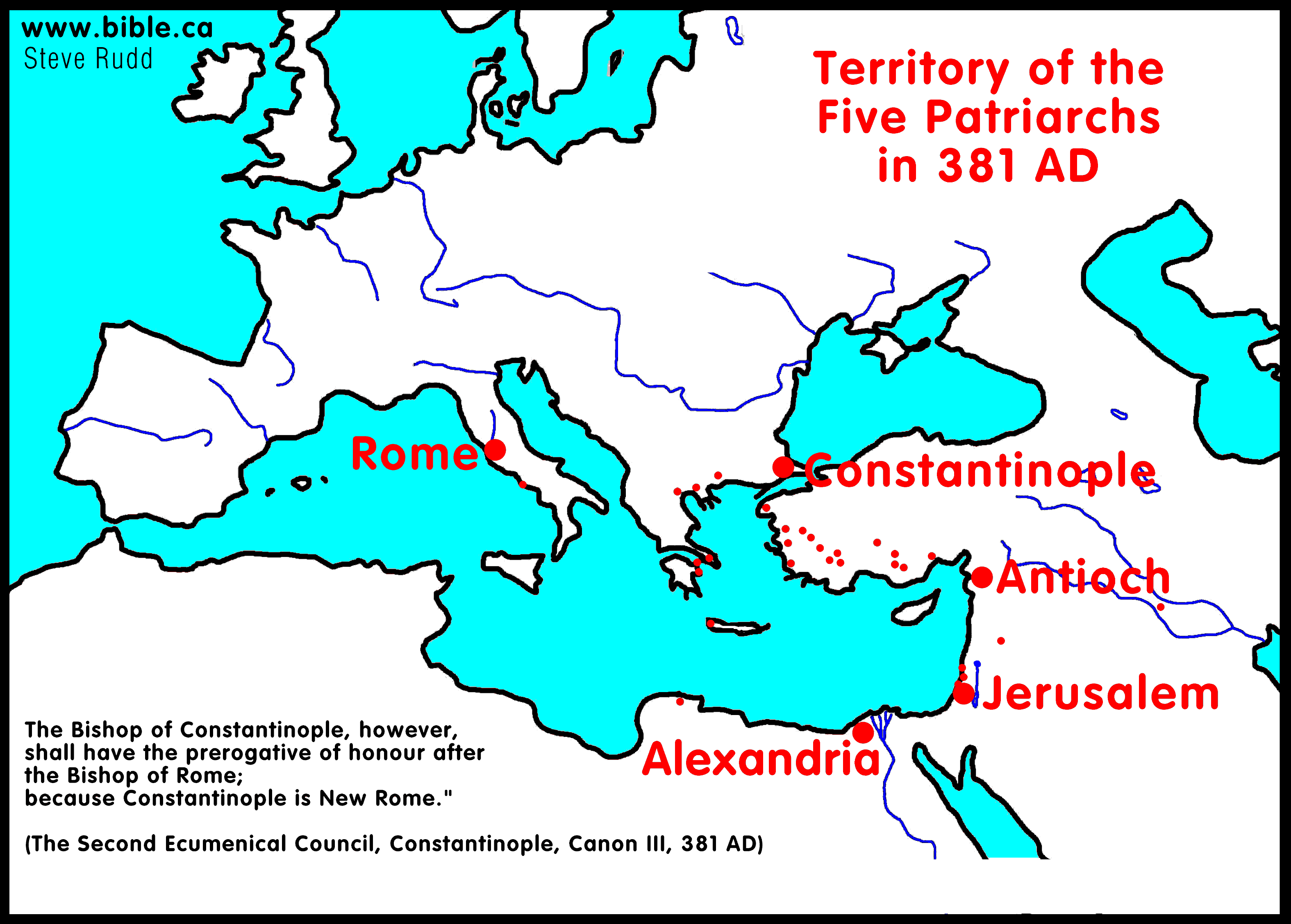
2. The world church Patriarchal system came into being in 381 AD (see below) and since two of the five are given no special position, it would seem the map was drafted before this period.
3. Red roofed buildings may be Roman outposts or Byzantine churches.
a. The Red roof is ceramic tiles.
b. Archeology has located Byzantine churches at all of the locations on the Peutinger map.
4. "Suggestions generally range from the first through the fourth or even early fifth centuries c.e. Those favoring the later end of the chronological spectrum generally point to the presence and prominence of the name “Constantinopolis,” a city built over the preexisting Byzantium and consecrated in 330 c.e. (Salway 2001, 44–47, fig. 3.3). At the same time, the map unexpectedly fails to include the principal fourth century route from Constantinople to Antioch via Asia Minor. Such discrepancies lead other scholars to view Constantinople as a post-original and rather clumsily executed insertion in the place of Byzantium (Talbert 2010, 109, 124, 133–36 with n. 11; Matthews 2006, 72). Even some who date the original map to the fourth century wisely recognize the likelihood that this rendition already represented the final of many evolutionary stages in which redactors repeatedly laid emergent details from the Roman Empire over an older map depicting much earlier times (Matthews 2006, 71–72; see Arnaud 1988, 309, for the view that the map’s wide range of apparent chronological indicators points to the diverse sources utilized by one cartographer, not to a series of individual redactors)." (THE TABULA PEUTINGERIANA: Its Roadmap to Borderland Settlements in Iudaea-Palestina, Ron E. Tappy, Near Eastern Archaeology, Vol. 75, No. 1, March, Footnote 12, 2012AD)
5. We conclude that the original map dates between 325-381 AD but there are many factors that can challenge this.
a. The original map may hundreds of years earlier or later than what we have concluded.
b. "In the lowlands between the coast and the highlands, the mapmaker recognized three important cities that lay east of the primary coastal artery: Luddis (Lydda), Amavante (Emmaus), and Betogabri (Beth Guvrin, Ptolemy’s βαιτογάβρα), from north to south. During the Severan rule (193–235 c.e.), these locations became Roman centers and received the names Diospolis, Nicopolis, and Eleutheropolis, respectively. As he did with Betogabri, the mapmaker identified Diospolis and Nicopolis only by their older names (as had Ptolemy in his earlier Geographia 5.16.5– 7). By the early third century c.e., on the other hand, the nonpictorial Itinerarium Antonini already employed the name “Diospolis” for Lydda and “Eleuteropoli” for Beth Guvrin (Cuntz 1990, 21, 150.3; 27, 199.3).11 In addition, while the TP cartographer drew a road between Lydda and Emmaus, he did not indicate its continuation along the borderlands to Beth Guvrin via the two Gaths, that is, the old Danite town of Gath-rimmon/Gittaim (twelve miles south of Lydda; Eusebius, Onom. 70.14–16, 71.15–17) and the larger center at Philistine Gath (ca. 5 five miles before reaching Eleutheropolis; Onom. 68.4–7; see Rainey and Notley 2006, 154–55). Collectively, these facts provide further clues to the pre-Severan date of the original map, and Roll (1983, 144) has observed that the road network presented here resembles closely the distribution of milestones dating to the year 162 c.e. That said, a clear date for the production of the original map remains impossible to determine.12 Broadly, the net result from numerous studies allows for the map's creation sometime between the reigns of Hadrian and Constantine, that is, from the mid-second century to the beginning of the fourth century c.e. (see nn. 8 and 12)." (THE TABULA PEUTINGERIANA: Its Roadmap to Borderland Settlements in Iudaea-Palestina, Ron E. Tappy, Near Eastern Archaeology, Vol. 75, No. 1, March, p46, 2012AD)
II. The Peutinger Map: secular or religious map?
1. The Peutinger Map has earmarks of both a secular and Religious map
2. Indications that the Peutinger Map is a secular, non-religious map for a number of reasons:
a. In 381 AD there were 5 patriarchs who governed the church worldwide within their allotted territories: Jerusalem, Alexandria, Antioch of Paul, Constantinople and Rome.
b. There is a large seated person on a throne at Rome, Constantinople and Antioch of Paul. Strangely Antioch is larger than Rome and Constantinople.
3. Even stranger is that Alexandria, second largest city in the empire, is not named but is represented by a badly faded symbol of the famous Lighthouse of Alexandria, which was one of the seven wonders of the ancient world. But the low status of Alexandria is a mystery.
a. "The mapmaker featured the fan of the Nile Delta (from Alexandria— identified only by its famous Pharos lighthouse and not by name—eastward to the Pelusiac Branch) and Antioch as the most prominent places in the eastern Mediterranean region (fig. 16). (Even though Constantinople appears on this map, the more impressive depiction of Antioch [see figs. 17a–c] may recall an earlier time when that locale represented the leading eastern city; see Matthews 2006, 72, 77–88; Dilke 1985, 116; also n. 8 above and n. 12 below; in any event, Talbert [2010, 124] understands the exceptional depiction of Antioch as a copyist’s later addition.) On the distorted map, however, the Delta lies not toward the eastern end of the Mediterranean but well out along its southern coast. The spatial allowance for Cyprus necessarily pushed Palestine and Sinai, along with the Delta, far to the west—so much so that the Dead Sea, Sinai Peninsula, and Egyptian Delta lie west of Rhodes, and, still farther west, Carthage sits almost directly south of Rome—just across a very narrow Mediterranean Sea." (THE TABULA PEUTINGERIANA: Its Roadmap to Borderland Settlements in Iudaea-Palestina, Ron E. Tappy, Near Eastern Archaeology, Vol. 75, No. 1, March, p45, 2012AD)
b.
Jerusalem is called, Aelia Capitolina, the anti-Jewish name given by
Hadrian in 135 AD. A religious map would never call Jerusalem this, given there
was a patriarch stationed there.
4. Are the Red roofed buildings Roman military/government outposts or Byzantine churches?
a. Archeology has excavated Byzantine churches at all the locations in Judea and Samara on the Peutinger Map so the buildings could clearly be churches!
b. I have personally have excavated a Byzantine church at Ai as well as hundreds of pieces of the ceramic Roman clay tiles that were put on the "Red" roofs of the buildings seen in the Peutinger map.
c. The shape of the Red roofed buildings on the Peutinger map are all square "pyramid" topped buildings like in standard modern house construction. There are no round red roofed buildings on the map.
d. Between town names are Roman Mile distances in block Roman Numerals. XVII = 17 Roman miles between towns. 1 roman mile = .92 standard miles and 1.5 km.
e.
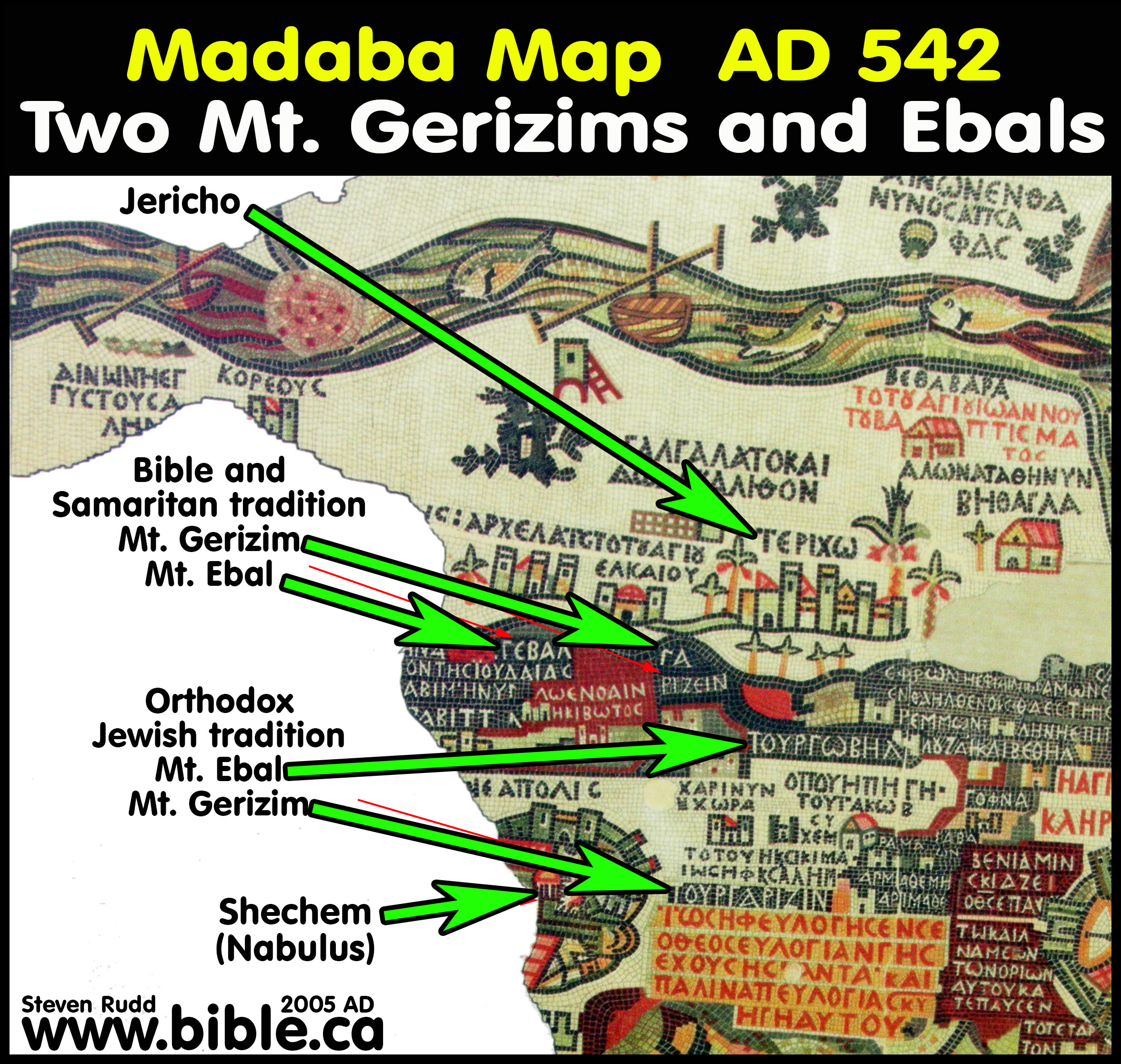
The Madaba
map (542 AD) is one of the oldest maps in the world on a mosaic floor in
the town of Madaba. It features rounded roofs for churches. On the
Peutinger map, all the roofs are double pyramid top shaped pitched roofs. It
makes it unlikely that they are churches but in fact are Roman towns, outposts
and fortresses. On the Madaba map below are round roofed churches at Shechem
and at EAKAIOY.
f. "The two terminus towns, Jerusalem and Ashkelon, both appear on the map with a pictorial symbol, or vignette: a pair of twin towers with a first-story door and a window in the gabled roof (see fig. 18). Nearly 78 percent (434 of 559) of all symbols utilized by the mapmaker represent some variation of this design (Talbert 2010, 118–19), and of the seven types of symbols that appear on the map (see Levi and Levi 1967, 65–66, 195–211, 225–32), this one seems to have indicated “places of administrative, commercial, military, or other well-known importance” (Talbert 2010, 121). Significantly, of the ten cities claiming some variant of this vignette in Cis- Jordan (from Tyre to Ashkelon), only Jerusalem and Ashkelon display an image in southern Palaestina (moreover, an identical image [Levi and Levi’s Type A.II.1] that distinguishes these two cities from all others in the region). Even the regional hub at Beth Guvrin appears without an icon of any kind, a fact that should raise no surprise if the original map predates the promotion of Bethogabri to Eleutheropolis around 200 c.e." (THE TABULA PEUTINGERIANA: Its Roadmap to Borderland Settlements in Iudaea-Palestina, Ron E. Tappy, Near Eastern Archaeology, Vol. 75, No. 1, March, p48, 2012AD)
5. Several Christian notations are made in the Sinai Peninsula:
a. The Red Sea and both Gulfs of Aqaba and Suez are on the map.
b. Mt. Sinai and the city of Aqaba is on the map.
c. There is even a notion that says: "The desert where the children of Israel who wandered for forty years guided by Moses"
6. Overall, however, the map smacks of secular with a small smattering of religious indicators.
a. "In any event, the map—like the nonpictorial Antonine Itinerary—awards no special prominence to the Holy Land or to the rising tide of Christian influence under Constantine (unless one takes the delineation in red [versus pale brown] of the name and physical location of the Mount of Olives as such an indicator [see n. 12 below], despite the fact that the iconic figures associated with Rome, Constantinople, and Antioch clearly exhibit non-Christian origins; see, e.g., figs. 17a–c). In any event, the PT predates the Madaba mosaic map (ca. mid sixth century c.e.) by more than two centuries." (THE TABULA PEUTINGERIANA: Its Roadmap to Borderland Settlements in Iudaea-Palestina, Ron E. Tappy, Near Eastern Archaeology, Vol. 75, No. 1, March, Footnote 8, 2012AD)
III. Exodus route of the Peutinger Map
1. Given the date of production between 330-381 AD during the era of Constantine, it is no surprise that the exodus route it noted.
2. Queen Helena (Constantine's mother) had a vision in a dream where the location of Mt. Sinai was pointed out to her by God… or so the story goes.
a. She chose the traditional location in the Sinai Peninsula at St. Catharine's monastery (Mt. Musa).
b. Almost no one today believes this is the correct location of Mt. Sinai.
3. Kadesh Barnea, although is not named, its original late bronze (1446 BC) location at the Nabatean city of Petra (100 BC), which was called Sela, during the monarchy (1000 BC).
a. What is interesting, is that Josephus and Eusebius both place Kadesh Barnea at Petra.
b. So while the location of Mt. Sinai was chosen by a dream, Kadesh Barnea was a known location through Josephus and Eusebius and his Onomasticon.
4. A fascinating historical feature is that during the period from about 600 -1762 AD very few knew the Gulf of Aqaba existed.
a. Carsten Niebuhr discovers the Gulf of Aqaba in 1762 AD and drew the first map with the Gulf of Aqaba.
b. It does not appear that any exodus route maps around the time of the discovery of the Peutinger Map (1500's AD) copied the shape of the Gulf of Aqaba.
c. Here
is a catalogue
of over 50 historic exodus route maps.
5. See details of the Exodus route of the Bible.

IV. MASTER CITY NAME LIST:
Translation list of Cities, churches, capitals and other notations of interest on the Peutinger Map:
|
|
Notes on how to use map: 1. Use "Control F" to find a city or place on our map in the list below. 2. Click on map for high resolution English translations of cities, towns and places. 3. For Google maps overlay: http://www.omnesviae.org/ |
A. Egypt and Exodus:
1. Lighthouse of Alexandria (faded image, Alexandria has a symbol only and is not named)
2. Tyconpoli (Asyūt)
3. Babylonia (Qasr esh-Sham ~ Al Qāhirah)
4. Pernicide portvm (Port Berenice, Egypt)
5. Pelvsio (Tell Al-Farama ~ El-Qantara)
6. Memphis (Menf ~ El Gïzeh)
7. Atribi (Athribis)
8. Havarra (Auara)
9. Psdio (Praesidio)
10. Ostracine (Ostrakine)
11. Notation on map: The desert where the children of Israel who wandered for forty years guided by Moses
12. Mount Sinai
13. Phara (Paran)
14. Haila (Aqaba: town on Gulf of Aqaba near elat)
15. Addianam (Timna?)
16. Cypsaria (Gypsaria)
17. Petris (Petra, Kadesh Barnea)
18. Thamaro (Tamara, Hazeva)
19. Lysa
20. Cypsaria (Gypsaria)
21. Oboda
22. Elvsa
23. Rhinocolura (Arish, Tharu)
B. Judea, Syria, Jordan:
1. Azoton (Ashdod, Azotus)
2. Ioppe (Joppa, Tel Aviv)
3. Ascalone (Ashkelon)
4. Betogabri (Beth Guvrin, Eleutheropolis) "By the early Severan period (199/200 c.e.), the city at Beth Guvrin/Beit Jibrin received the new name Eleutheropolis and became the most important center in the foothills of Judah." (THE TABULA PEUTINGERIANA: Its Roadmap to Borderland Settlements in Iudaea-Palestina, Ron E. Tappy, Near Eastern Archaeology, Vol. 75, No. 1, March, p46, 2012AD)
5. Helya Capitolina (Jerusalem)
6. Notation on map: Antea Dieta Herusalem (“previously called Jerusalem”)
7. Amavante (Emmaus)
8. Miletum
9. Luddis (Lod, Lydda)
10. Cofna (Gophna, Jifna, Ophni)
11. Arcelais (Archelaus)
12. Coabis
13. Thantia (Thainatha)
14. Rhose
15. Neapoli (Nablus, Shechem)
16. Fl Jordanis
17. Bostris
18. Herichonte (Jericho)
19. Cesarea (Caesarea)
20. Tyberias (Tiberias)
21. Thora (Nahsholim)
22. Ptolomaide (Acco)
23. Adammontem
24. Damaspo (Damascus)
25. Heldo (Libo)
26. Lavdicia Scabiosa (Laodicea ad Libanum)
27. Aenos
28. Cehere (Qara)
29. Danova
30. Nezala (Al Qaryatayn)
31. Ocvrvra (Otthara)
32. Heliaramia
33. Theleda
34. Chanata (Canatha, Kenath, Nobia Qanawat)
35. Mt. Hermon
36. Gadda (Az-Zarqa)
37. Hatita (Kh. es-Samra)
38. Adraha (Dar'a)
39. Capitoliade (Beit Ras)
40. Cadara (Gadara)
41. Abila (Wadi Barada)
42. Adarin (Atera)
43. Casama (an-Nabk)
44. Balbyblos
45. Botrvs (Batroun)
46. Caporcotani (Megiddo or Aruna? Same as Caparcotia of Ptolemy, the map says it is 28 roman miles (41km) from Beth Shean on the road to Caesarea, Megiddo is 30 km, Aruna is 40)
47. Philadelfia (Ammon)
48. Scyropolis (Beth Shean)
49. Tyro (Tyre)
50. Sydone (Sidon)
51. Berihto (Beirut, Berizto)
52. Biblo (Byblos)
53. Paphos
54. Nemesa (Homs)
55. Cesarea Paneas (Banyas, Caesarea Philippi)
56. Damaspo (Damascus)
57. Seleucia
58. Antioch (of Paul)
59. Eliopoli (Baalbek)
60. Raphanis (Raphia, Raphaneai)
61. Apamia (Kafat el-Mudîk)
62. Larissa (Shaizar)
63. Epifania (Hama)
64. Ortosias (Orthosia)
65. Tripoli
66. Palto (Paltos)
67. Gabala (Jablah)
68. Lavdiciae (Laodicea, Al Lathqiyah)
69. Seleucia (Samandağ)
70. Rosos (Rhosos)
C: Asia and Turkey:
1. Island of Cypress
2. Alexandria Catisson (Iskenderun)
3. Aregea (Yumurtalık)
4. Zimara
5. Polemonio (Bolaman)
6. Amasia (Amasya)
7. Gangaris (Çankırı)
8. Tavio (Büyüknefes)
9. Ancyra (Ankara)
10. Zela (Zile)
11. Comana Pontica (Gümenek)
12. Comana Capadocia
13. Mazaca Cesarea (Kayseri)
14. Neocesaria (Niksar)
15. Tyana (Kemerhisar ~ Niğde)
16. Lavdiciaca tacecavmeno (Ladik, Laodicea Combusta)
17. Pesinvnte (Ballıhisar ~ Sivrihisar)
18. Antiochia Pisidia (Yalvaç)
19. Pompeiopolis (Mersin)
20. Animvrio (Anamur)
21. Phaselis (Kemer)
22. Sida (Side ~ Manavgat)
23. Atalia
24. Selinvnte (Selinti ~ Gazipaşa)
25. Yconio (Konya)
26. Ivliopoli (Emremsultan)
27. Ephesvm (Ephesus)
28. Smyrna (zmir)
29. Pergamo (Pergamum, Bergama)
30. Tyatira (Thyratira, Akhisar)
31. Appollonia
32. Sardes (Salihli)
Conclusion:
1. The Peutinger Map was likely produced in the great expansion during Constantine the Great between 325-381 AD but factors could change this in hundreds of years either way.
2. The Peutinger Map may in fact be a primarily religious map that marks the locations of Byzantine churches.
3. The exodus Route information is likely authentic to the 4th century AD given the rise in interest after Helena chose Mt. Sinai in the Sinai Peninsula after being directed in a dream.
4. The Peutinger Map clearly and accurately draws (even with the distortion) the Gulf of Aqaba.
a. Cartographers from 1400 up to 1762 AD had no idea that the Gulf of Aqaba existed which reinforced the delusion that the Sinai Peninsula could be considered out of Egypt and in Arabia
b. Carsten Niebuhr discovers the Gulf of Aqaba in 1762 AD and drew the first map with the Gulf of Aqaba.
5. Here is a catalogue of over 30 historic exodus route maps that had no idea that the Gulf of Aqaba existed.
By Steve Rudd: Contact the author for comments, input or corrections.
