The Ascent of Akrabbim: (Ascent of Scorpions)
|
Akrabbim is the word for scorpion, so it is literally the "ascent of scorpions".
It was north of but near Petra (Sela) being a southern marker for the boundaries of the Amorites: Judges 1:36 |
|
Introduction:
1. It was a reference used to determine the southern border of Israel and was just north of Kadesh Barnea (Near Petra): Numbers 34:4; Joshua 15:3
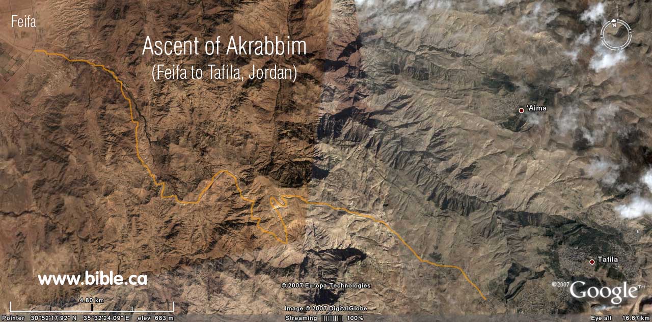
2. We feel the best candidate for the Ascent of Akrabbim is indicated by the blue #1 on the map below that starts at the dead sea and travels east from modern "Feifa" to "At Tafilah" in Jordan. Our close second choice, is blue #2 on the map below that starts from the Arabah valley and goes up the ravine to Dana, Jordan.
3. Traditionally, ascent of Akrabbim, has always been looked for on the western edge of the Arabah valley, but we feel this is wrong and that an easterly ascending path towards modern Jordan is the best choice. There are two reasons for this choice.
a. First, the Bible says that the Ascent of Akrabbim is north of, but not part of the wilderness of Zin. Joshua 15:3 (Kadesh Barnea was in the wilderness of Zin).
b. Second, Judges 1:36 defines the territory of the Amorites during the period of the judges at about 1340-1096 BC to be upward from both the ascent of Akrabbim and Petra. We know that the Amorites were transjordan at this time.
c. It makes better sense to use and easterly ascending path into the territory of the Amorites, rather than the traditional westerly route that ascends into the actual territory occupied by Judah at that time. Of the two candidate "easterly ascending: routes, only the northern one (blue #1 on map) fits all the Bible data perfectly.
4. A major discovery was made by looking at a single Bible verse: Judges 1:36. We can determine that the ascent of Akrabbim was on the east side of the Arabah valley because of Judges 1:36: "The border of the Amorites ran from the ascent of Akrabbim, from Sela [Petra] and upward." While some may argue that Sela does not refer to Petra, although we know it does, everyone agrees the territory of the Amorites is transjordan. So if the ascent of Akrabbim is being used as a boundary marker for the borders of the Amorites, then the ascent of Akrabbim must be tranjordan. It would make no sense to mark the boundary of the Amorites if the ascent of Akrabbim is on the western side of the Arabah because everyone knows the Amorites were located in what is Modern Jordan at the time of Joshua.
5. Another evidence that the ascent of Akrabbim travels east from the Arabah Valley up onto transjordan Jordan, and not west into the land of Judah, is the scant references to it in the rest of the Bible. If it was within the land of Judah, as is traditionally suggested (blue #3 on the map below) then we should find several references to it within the normal course of events. But we find this same pattern of lack of references to all the exodus route locations outside the boundaries Israel: ascent of Akrabbim, Kadesh, wilderness of Zin, wilderness of Paran, Mt. Sinai.
A. What the Bible says about the ascent of Akrabbim:
- "Then your border shall turn direction from the south to the ascent of Akrabbim and continue to Zin, and its termination shall be to the south of Kadesh-barnea; and it shall reach Hazaraddar and continue to Azmon." Numbers 34:4
- "Then it proceeded southward to the ascent of Akrabbim and continued to Zin, then went up by the south of Kadesh-barnea and continued to Hezron, and went up to Addar and turned about to Karka." Joshua 15:3
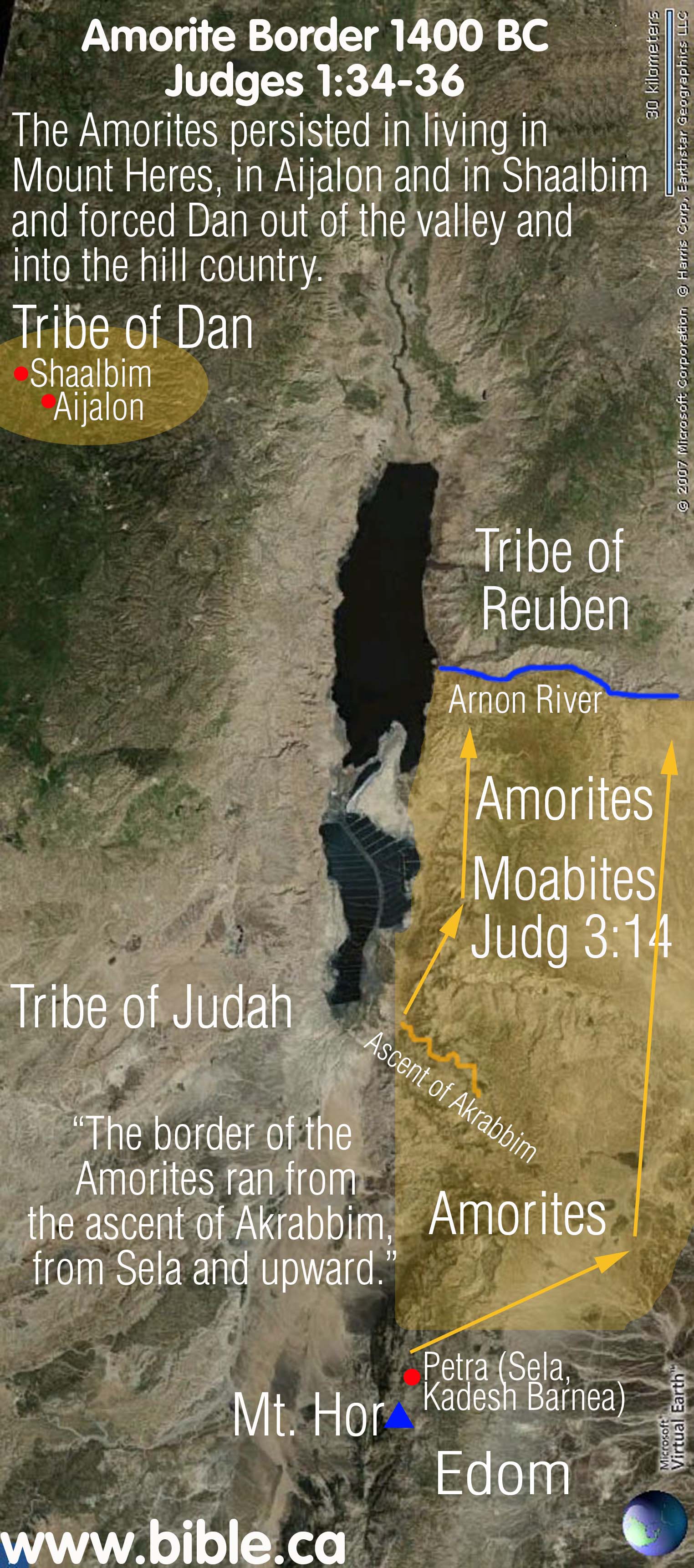
- "The border of the Amorites ran from the ascent of Akrabbim, from Sela [Petra] and upward." Judges 1:36
B. How to interpret Judges 1:34-36:
"Then the Amorites forced the sons of Dan into the hill country, for they did not allow them to come down to the valley; yet the Amorites persisted in living in Mount Heres, in Aijalon and in Shaalbim; but when the power of the house of Joseph grew strong, they became forced labor. The border of the Amorites ran from the ascent of Akrabbim, from Sela and upward." Judges 1:34-36
|
|
In 1406 BC, when the Israelites first came to the promised land, the Amorites controlled the transjordan from the Arnon River to Mt. Hermon and many key cities west of the Jordan including Jerusalem and Hebron. However, after defeating the Amorites, with God's help, they were displaced south of the Arnon River to Petra. But they retained one small stronghold west of the Jordan in the territory of Dan, where they occupied Mount Heres, Aijalon and Shaalbim. In a kind of domino effect, just as Reuben displaced the Amorites moved south and displaced the Moabites and the Edomites. The Edomites were in turn, displaced south to Mt. Seir, (just north east of the Red Sea). When Israel first crossed the Jordan with Joshua, the Amorites controlled both Hebron, Jerusalem and Engedi. They were defeated and driven transjordan between the time of Joshua to David. Of course under David and Solomon, they were completely driven east and south of the entire transjordan area for a time, until the Assyrian captivity in 722 BC. |
Discussion:
- Click here for a complete discussion on the Amorites
- Judges 1:34-36 recounts places where Israel failed to drive out the Amorites within the promised land. The narrative begins in the tribe of Dan, an area just north west of Jerusalem and how the Amorites occupied key areas within Dan's inheritance. It mentions two towns of Aijalon and Shaalbim whose location we can generally identify.
- Oddly, though, the narrative then gives the border of the Amorites starting from the "Arabah Valley and upward". Such a border definition would basically include 80% of the promised land. Its like saying, the territory of the Amorites is everything north of the southern end of the Dead Sea. So what shall we make of this?
- It is important to note a few things about the words in this verse. The word "upward" is common and non-specific. The word "border" is the common word for denoting territory or a border. But it is well known in the Bible that the expression "went up" or "went down" referred to elevation. For example: "Joseph went up from the Nazareth (350 meters above sea level) to Bethlehem (600 m)" Luke 2:4. And again: "Jesus went down (from Cana of Galilee 250 m) to Capernaum (-150 m), then Jesus went up to Jerusalem (750 m)." John 2:11-13. Therefore, the word, "upward" as it is used in Judges 1:36 likely refers to elevation.
- So when we apply this common Jewish usage of "upward" in Judges 1:36, we read the text: "The area occupied and controlled by the Amorites started in the valley of the Arabah (50 m) and went up in elevation into the promised land from there."
- The two lowest beginning points are the "ascent of Akrabbim" and "Sela" (or Petra). At the time of the failed conquest immediately after the spies came back and gave a bad report, it was the Amorites that repelled the disobedient Jews out of the Negev and back to Petra (Kadesh Barnea was located at or near Petra.)
- Now we need to discuss how this impacts our choice of where the "ascent of Akrabbim" is located. There are in fact, 5 possible choices of where this ascent is located. Can Judges 1:36 give us any clues as to which side of the Arabah valley the ascent of Akrabbim on? Since Sela (Petra), is a known location on the east side of the Arabah valley, it seems logical to expect that the ascent of Akrabbim would be located on the west side. If this were truly the case, then it would indicate that the Amorites occupied from the upward and westward ascent of Akrabbim and upward and eastward from Petra. This would make good sense, since Judges 1:34-36 starts with the Amorite occupation of the territory of Dan "upward and west" of the Arabah valley. But this may not be the case, as there are other options.
- If the ascent of Akrabbim is located on the eastern Arabah valley ascending upwards towards modern Jordan, as we believe it does, the text of Judges 1:34-36 also fits nicely. Since the Amorites were a very powerful nation, when Israel displaced them, they in turn displaced the Moabites and the Edomites out of their territory in 1406 BC. Remember, the Amorites had the territory north of the Arnon River and controlled Jerusalem, Hebron etc. The tribe of Reuben, Gad and Manassah possessed the territorial stronghold of the Amorites between the Arnon River and Mt. Hermon.
- Keeping this in mind when reading Judges 1:34-36, means that the Amorites moved south of the Arnon River, displaced the Moabites and Edomites down as far as the ascent of Akrabbim (east side of the Arabah at the base of the Dead Sea ascending into modern Jordan) and Petra. The one exception was a tiny stronghold in the tribe of Dan as Judges 1:34-36 indicates.
C. Locating the ascent of Akrabbim: (Five possible choices)
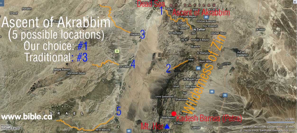
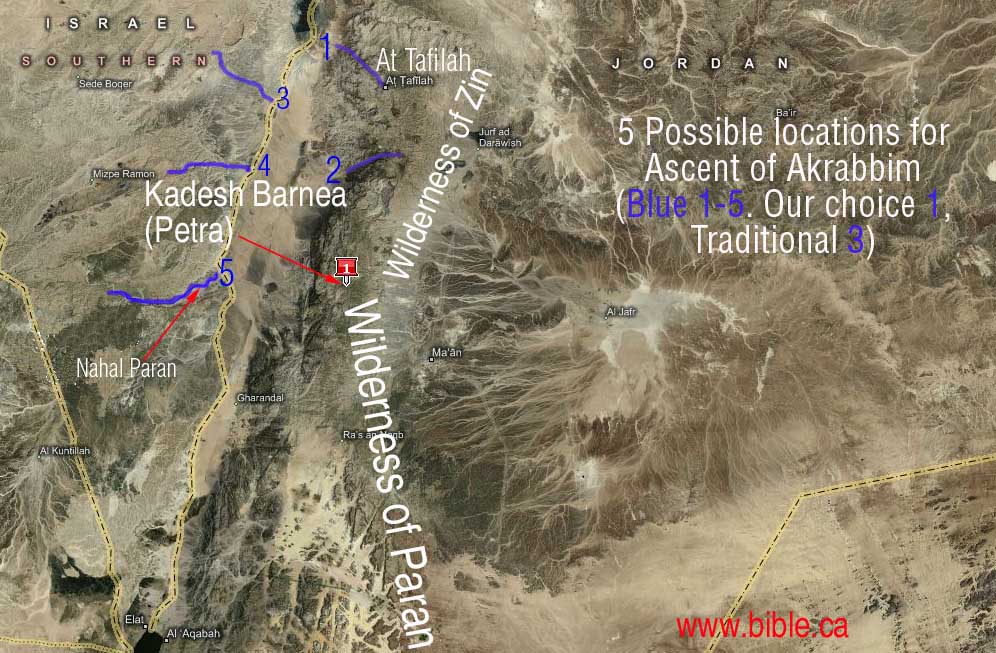
- (blue #1 on map) Our choice for the ascent of
Akrabbim is marked by the blue #1 on map. The
most likely easterly ascending route would follow Highway #60. The modern
highway attests to its ancient usage. This route starts immediately at the
bottom of the Dead Sea and moves up the ravine to the modern town of
"At Tafila". Today, this route is the only modern highway
(Highway #60) for cars between the Arabah Valley and the plateau in modern
Jordan between the Dead sea and the Gulf of Aqaba (Red Sea). Jordanian
Highway #60 starts at the town of Fifa in the Arabah Valley and passes
through At Tafila and continues east. Here at At Tafila, it intersects
with Highway #35. Highway #35 travels north to
Amman and south through Petra and all the way to the Gulf of Aqaba. (After
connecting with Highway #15). Highway #35 is the main route between the
Aqaba and Amman and #15 is the western-most highway in Jordan that traces
the high ridges on top of the Arabah Valley and is very scenic. Highway
#35 and 15 both run parallel with each other in a north-south direction. The
mountains on the eastern Arabah valley are very high (similar to the Rocky
Mountains in Canada) and form such a formidable barrier that there is no
way to get from the valley into the Jordan Plateau except at either end of
the range at the Dead Sea end via Highway 60 or Red Sea via Highway 35. This
is the territory of Edom. God told Edom "The
arrogance of your heart has deceived you, You who live in the clefts of
the rock, In the loftiness of your dwelling place, Who say in your heart,
'Who will bring me down to earth?' "Though you build high like the
eagle, Though you set your nest among the stars, From there I will bring
you down," declares the Lord." Obadiah 3-4 But for man it
was an untouchable fortress.
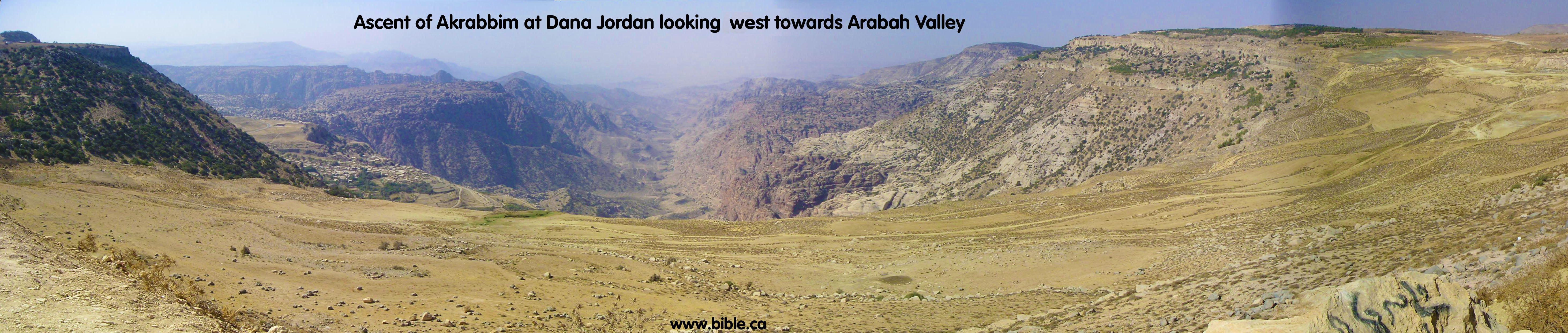
- (blue #2 on map) Our second choice for the ascent
of Akrabbim starts on the eastern edge of the Arabah valley and ascends
eastward into modern Jordan. Although there are two possible routes, the most
likely route starts 35 km south of the Dead Sea, due north of Petra, and
exactly opposite Nahal Paran and ascends into Modern Jordan. This route is
quite obvious since it follows a major geological valley canyon from the
Arabah valley east, onto the plateau in modern Jordan.
- (blue #3 on map) This is the modern choice of location of the ascent of Akrabbim. This route, although it is not the ascent of Akrabbim, does indeed travel along an ancient route from the Arabah valley, through one of Solomon's border fortresses he built at Ein Haseva and into the promised land. It matters not that we reject this as the location for the Ascent of Akrabbim, for the fact remains that this was an ancient route used from the time of Solomon. Although it is a possible location for the Ascent of Akrabbim, there is a better transjordan choice, on the east side of the Arabah valley. (blue #1)
- (blue #4 on map) This possible location for the Ascent of Akrabbim, is located half way between Nahal Paran and the Dead Sea on the west side of the Arabah valley, 35 km south of the Dead Sea. Although its path is not known for sure, it likely begins from the Arabah valley near the modern town of En Yahav and follows the wadi drainage path that leads to the south eastern end of Mizpe Ramon crater. If not towards the Mizpe Ramon crater, then it branches north along the same wadi onto the plateau.
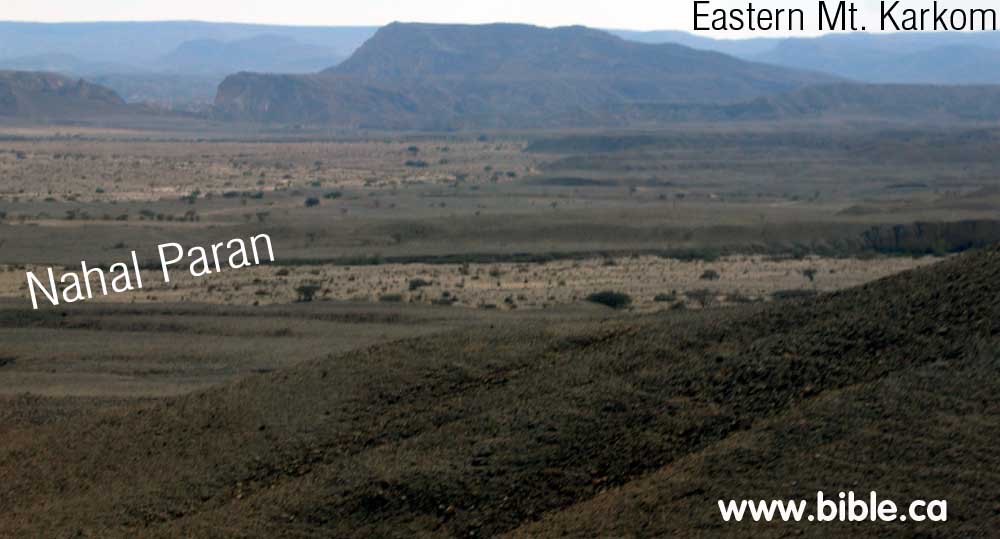
- (blue #5 on map) Another alternative, however is
that the Ascent of Akrabbim follows the Nahal Paran. This is 65 KM south
of the dead sea and is located on the east side of the Arabah valley
ascending westward towards the Wadi El Arish drainage system. This is
unlikely since it really is not much of an ascent, but a flat wide
drainage area. Below is a photo of the center of the Nahal Paran ditch
facing west towards Mt. Karkom ascending up the bank out of the valley on
highway #40 where Nahal Paran intersects Nahal Sira. As you can see, it is
not much of an ascent, more like a wide flood plain. It is not likely that
the Nahal Paran is the ascent of Akrabbim.
D. Photo gallery of the ascent of Akrabbim (blue number 1 on map)
(Click on photo for high resolution)
|
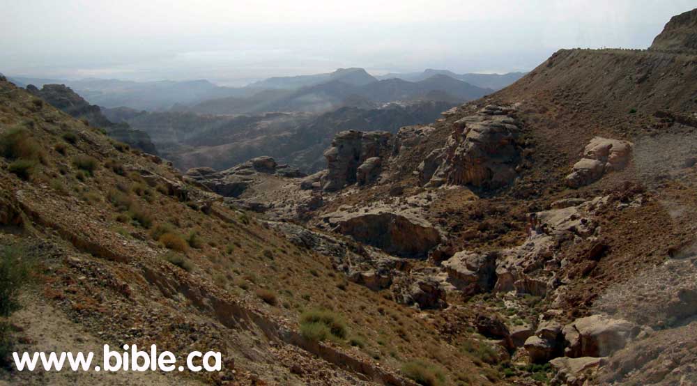
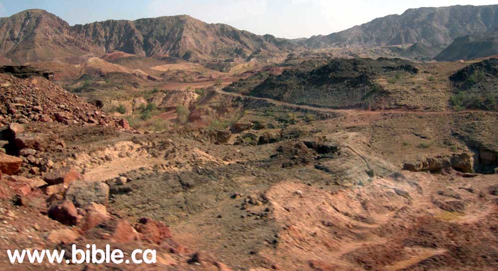
Travelling along Highway # 60 starting from the Arabah Valley very near the Dead sea looking south. |
|
|
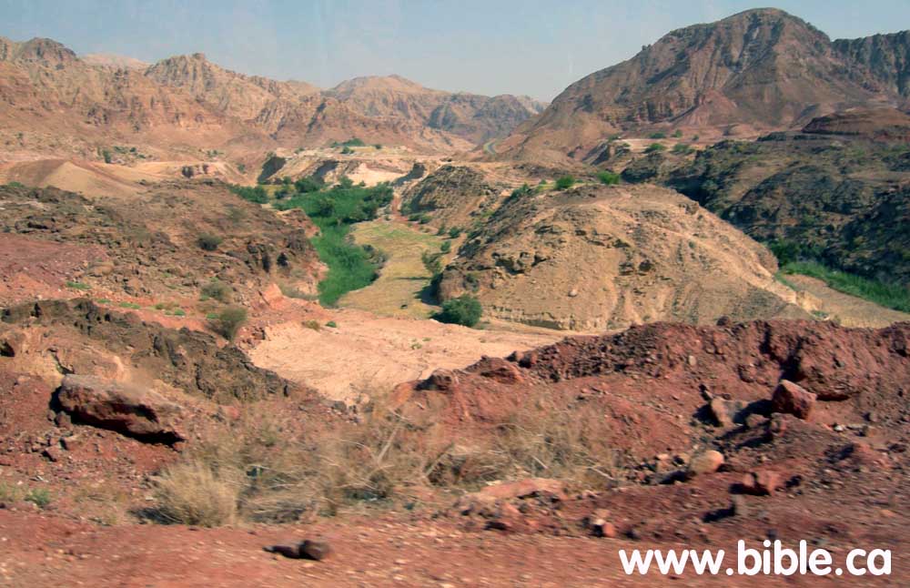
Travelling along Highway # 60 looking east up the wadi valley. You can see the local dirt road used by the Bedouin. |
|
|
Travelling along Highway # 60 looking east up the valley. |
|
|
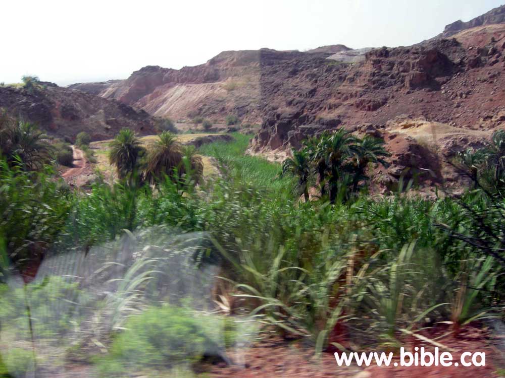
Travelling along Highway # 60 looking west and down an intersecting wadi with an oasis (running water) |
|
|
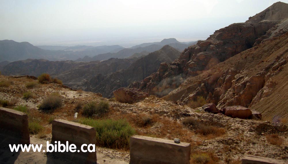
Travelling along Highway # 60 looking west from the top of the plateau to the Arabah Valley. |
|
|
Travelling along Highway # 60 looking west to the Arabah Valley. |
|
|
Travelling along Highway # 60 looking west to the small towns that dot the plateau. This is modern "At Tafila" in Jordan where it intersects with Highway #35. |
|
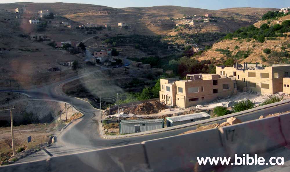
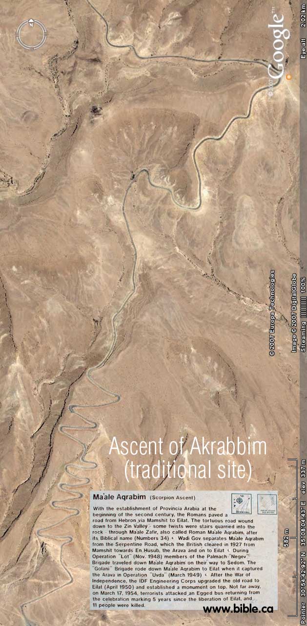
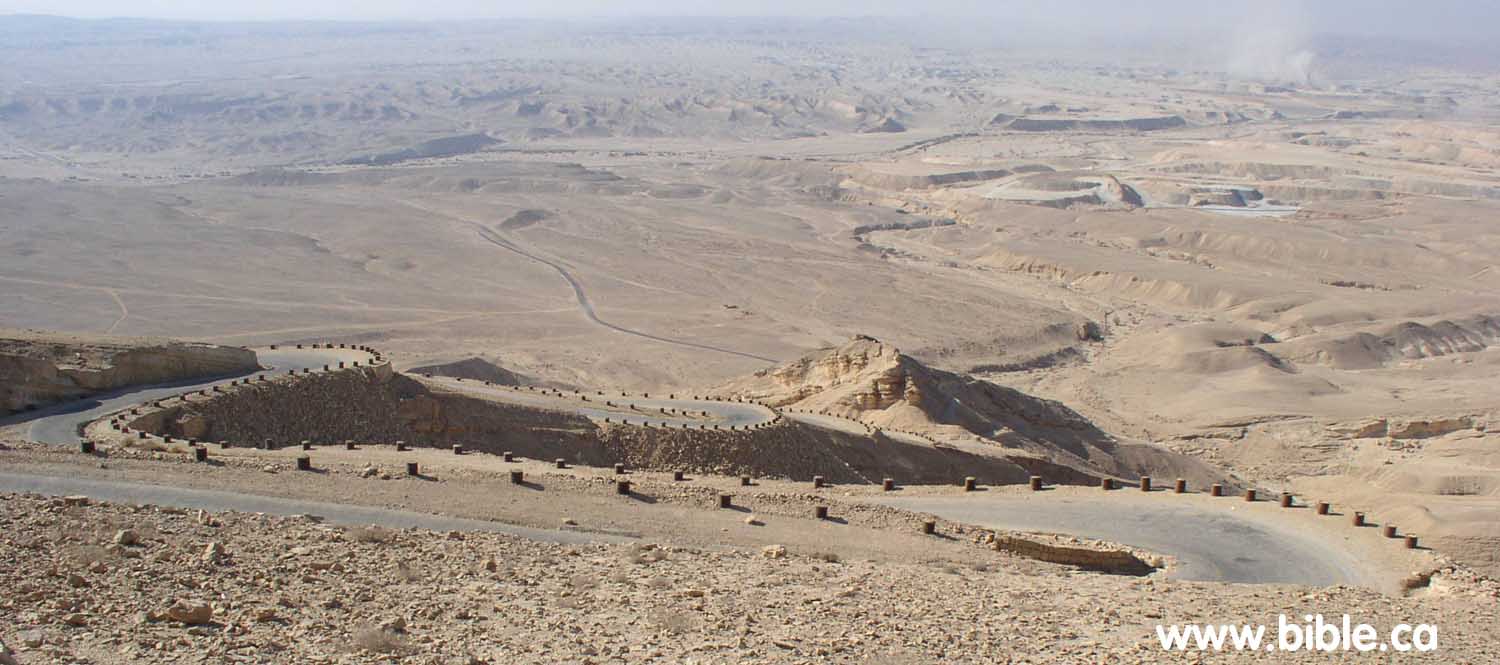
E. The traditional (wrong) location of the ascent of Akrabbim in Israel today:
|
|
|
|
|
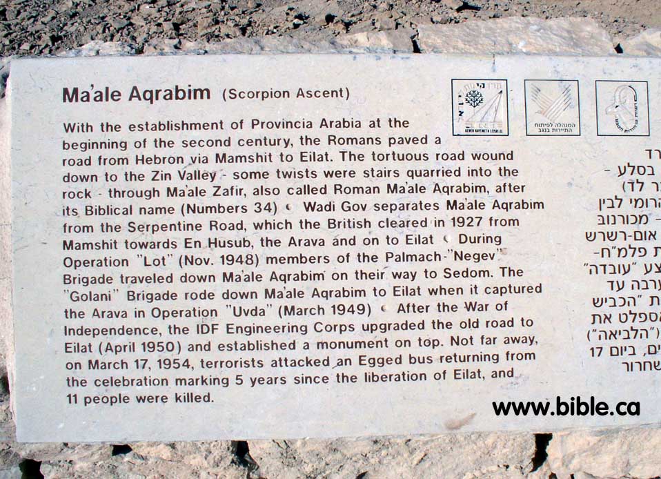
Ma'ale Aqrabim (Scorpion Ascent) With the establishment of Provincia Arabia at the beginning of the second century, the Romans paved a road from Hebron via Mamshit to Eilat. The tortuous road wound down to the Zin Valley - some twists were stairs quarried into the rock - through Ma'ale Zafir, also called Roman Ma'ale Aqrabim, after its Biblical name (Numbers 34) Wadi Gov separates Ma'ale Aqrabim from the Serpentine Road, |
|
which the British cleared in 1927 from Mamshit towards En Husub, the Arava and on to Eilat During Operation "Lot" (Nov. 1948) members of the Palmach-"Negev" Brigade traveled down Ma'ale Aqrabim on their way to Sedom. The "Golani" Brigade rode down Ma'ale Aqrabim to Eilat when it captured the Arava in Operation "Uvda" (March 1949) After the War of Independence, the IDF Engineering Corps upgraded the old road to Eilat (April 1950) and established a monument on top. Not far away, on March 17, 1954, terrorists attacked an Egged bus returning from the celebration marking 5 years since the liberation of Eilat, and 11 people were killed." (highway inscription) |
|
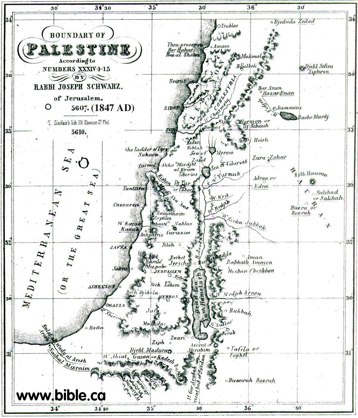
F. In 1847 AD the ascent of Akrabbim was located near Ma'ale Aqrabim:
Rabbi Joseph Schwarz may in fact be the one who is responsible for misleading the search for Kadesh Barnea in the first place. He wrongly places Kadesh south of Gaza based upon similarity of names between several languages.
|
Descriptive
Geography and Brief Historical Sketch of Palestine. Map by Rabbi Joseph Schwarz in 1847 of promised land 1847 AD The Ascent of Akrabbim ???? ?????? Means literally the ascent of Scorpions, so to say, a most dangerous hill. The celebrated Saadia renders it, in his Arabic translation of the Scriptures, Ali Akbah Akrabin, i.e. or the country of Akbah Akrabin. The Arabs call the eastern bay of the Red Sea, Bachr Akabah; also the entire valley, from the Dead to the red Sea, they call ???? Araba, Al Gor, also Akabah (see father down, art. Kikkar Hayarden ??? ????? ). It is therefore to be presumed that this ascent of Akrabbim must be sought for in this valley. And, in truth, westward from the village Chansiri, on the edge of Al Gor, not far from the Wady Kurahy, there is a fearfully high and precipitous rocky acclivity, which to pass is extremely dangerous; and I suppose this is to be the Ascent of Akrabbim, here mentioned. [footnote: I explain Judges 1:36, ????? ????? ????? ?????? ????? ????? "And the coast of the Amorite was from the going up of Akrabbim, from the rock and upward," to refer to the city Selah, mentioned in 2 Kings 14:7, which was also called Joktheel, and at a later period Petra, and which is also found in this Al Gor; and this leads us to place the ascent of Akrabbim northward of Selah or Petra.] Kadesh-Barnea. ??? ???? No geographer or traveller has hitherto succeeded to discover a trace of this place, But I believe that, through means of our own literary treasures, I shall be able to throw some light on this obscure name, so that it will be possible to fix its position with some degree of certainty. Our commentators Onkelos, Jonathan, and the Targum Yerushalmi, all translate Kadesh-Barnea with ??? ???? Rekam Gaya. In this connexion I have also discovered that the Wady al Arish (see farther down, under Nachal Mitzrayim ??? ?????), united eastwardly with another Wady, which the Arabs call Wady Abiat (White Valley), or Wady Gaian. Another Wady, called by them Wady Bierin, is connected on the southeast with the Wady Gaian. I have scarcely any doubt but that the name of Gaian is derived from the ancient Rekam Gaya, and that Bierin is derived from the ancient Barnea; although the Arabs believe that this name is applied to the Wady because there are found in it several wells. I therefore believe that the true position of Kadesh-Barnea is to be found at the point where the Wadys Gaian and Bierin unite; and this is about 45 English miles south of Gaza |
G. Here are photos of a scorpion taken near the ascent of Akrabbim in Israel:


By Steve Rudd: Contact the author for comments, input or corrections.
