Agatharchides 169 BC: Petra and the Wilderness of Shur
Arabia as being confined to modern Saudi Arabia to the exclusion of the modern Sinai Peninsula
(Greek historian and geographer)
Agatharchides of Cnidus, On the Erythraean Sea 169 BC, translated by Stanley M. Burstein, 1989
|
|
On the Erythraean Sea by Agatharchides of Cnidus, 169 BC Agatharchides is unique in that he is one of the few geographers of his day that understood the Gulf of Aqaba, which he calls "Laeanites Gulf". He restricts "Arabia" to south and east of the Gulf of Aqaba. Agatharchides did not sail down the Laeanites Gulf, but says the Arabs live on the east shore, not the left and that at the end of the Gulf, is Petra! As he sails down the Red Sea towards the Indian Ocean, he describes all the various tribes of Arabians. No Arabians lived in the modern Sinai Peninsula. |
Dictionary of Ancient Place names:
1. Arabia Nabataea = Arabia Petra located inside Arabia Felix
2. Elanite/Ælanitic/Aelanites/Laeanite gulf = Gulf of Aqaba
3. Erythræan Sea = Red Sea
4. Eudaimon Arabia = Arabia Felix
5. Happy Arabia = Arabia Felix
6. Heroopolite gulf = Gulf of Suez
7. Idumeans = Idoumaia = Edomite Jewish proselytes living in the Judean Negev.
8. Nabatea = Nabatæa = Nabatean Kingdom = one of many Arab tribes in Arabia Felix
9. Petra = capital city of the Nabatean Kingdom in the district of Arabia Felix.
Introduction:
1. Agatharchides, was a Greek historian and geographer who lived in Cnidus about 169 BC, wrote a book called "On the Erythraean Sea." (Red Sea).
a. In this book, Agatharchides describes Arabia as being confined to modern Saudi Arabia to the exclusion of the modern Sinai Peninsula in 169 BC.
2. The words of Agatharchides have been reconstructed from three other ancient authors: Diodorus (49 BC), Strabo (15 AD), Photius (897 AD).
a. There are several extant copies of each of the sections labeled XXa, XXb, XXc etc.
b. The original script of Agatharchides, often has three readings or "fragments", much like the synoptic gospels.
c. For example, the text runs with the following fragments: 87a, 87b, 88, 89a, 89b, 89c.This means there are two versions (fragments) of section 87, only one version (fragment) of section 88 and three versions (fragments) of section 89.
3. Arabia was in Saudi Arabia not the Sinai Peninsula:
a. The southern Sinai Peninsula, which was only beginning to attract the economic interests of the Romans at this time, mattered little to Alexandrians.
b. Agatharchides make no description of any kind of the modern Sinai Peninsula, like many other geographers in the ancient world, he just ignores it.
c. The Arabian Peninsula mattered greatly: “The merchants, dock workers and shopkeepers of Alexandria profited nicely from the massive trade that passed through their city to and from southern Arabia and India. For them, "Arabia" meant the Arabian Peninsula. Precisely the same usage is found in the works of Alexandrian intellectuals such as the geographers Eratosthenes and Agatharchides.” (Mt. Sinai in Arabia?, Allen Kerkeslager, Bible Review, BR 16:02, Apr 2000)
d. It is clear that Agatharchides restricted the Arabs and Arabia to modern Saudi Arabia. He did not place the Arabs and Arabia anywhere in modern Sinai Peninsula.
4. As Agatharchides' narrative continues, he moves down the east coast of the Red Sea to the Arabian Sea or the Erythraean Sea as he calls it.
a. This is significant, for in the chapter before, Agatharchides discusses the western coast of the Red sea and there he starts in Egypt.
b. This proves that Agatharchides defined Arabia, starting at the Straits of Tiran and the east shore of the Gulf of Aqaba.
5. Erythraean Sea is the Arabian gulf including the Gulf of Suez:
a. To the ancient geographers, the "Erythraean Sea" was defined in a wide variety of ways which often broadly included the Red Sea, the Arabian Sea and the Persian Gulf. Agatharchides seems to follow this definition.
b. Agatharchides makes no distinction between the Gulf of Suez and the main section of the Red Sea. He sees the Red Sea as one continuous finger of water and he calls the Red Sea, the "Arabian Gulf".
6. Elanite/Ælanitic/Aelanites/Laeanite gulf is the Gulf of Aqaba:
a. Agatharchides distinguish the Gulf of Aqaba from the Arabian Gulf (Red Sea) calling it the "Laeanites Gulf".
b. Agatharchides calls the Gulf of Aqaba the "Laeanites Gulf" and the remaining straight section of the Red Sea that extends from the Persian Gulf to Egypt, the "Arabian Gulf".
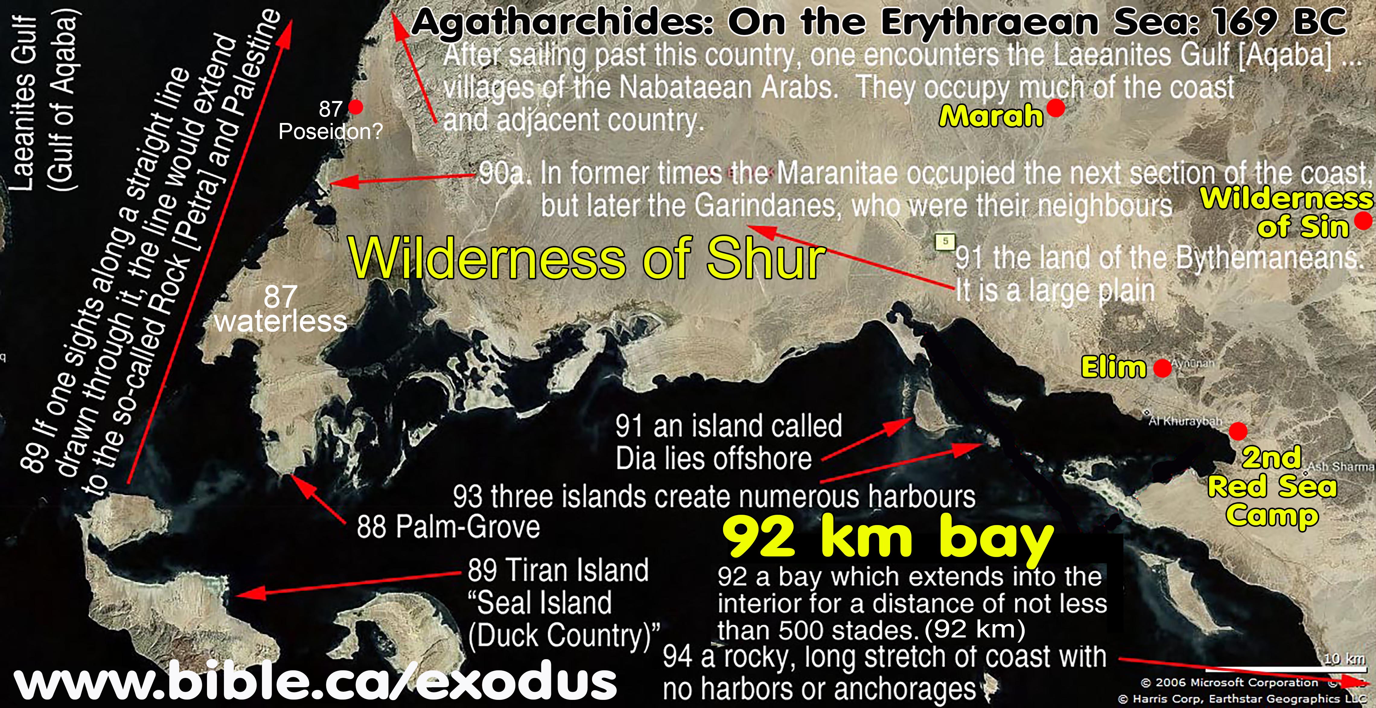
c. Unlike other geographers before him, he was aware of the Gulf of Aqaba (he called it Laeanites Gulf) but interesting, his voyage and narrative do not take him to the end of this gulf. While he describes the east coast of the Red Sea down to the Arabian sea in great detail, but has almost no description of the Gulf of Aqaba except that the Nabataeans live along the east coast and that Petra is at the end of the Gulf. It is clear he did not sail this section, but was aware of its basic geography.
7. Straits of Tiran and Seal Island = Tiran Island, then south to modern Mecca:
a. “Seal Island is the Island of Tiran” (Agatharchides of Cnidus, On the Erythraean Sea 169 BC, Stanley M. Burstein, p148, 1989 AD)
b. Tiran Island during the Exodus in 1446 BC is called Baalzephon or temple of Baal. Notice that three nearby islands are each temples of pagan gods. This shows a pattern in the region of islands being sacred places of worship: “Offshore from the territory just mentioned lie three islands which create numerous harbours. The first of these islands is named the Shrine of Isis, the second Soukabya and the third Salydo.” (93a)
c. His narrative begins at the Straits of Tiran, then move south to the Arabian Sea (Red Sea) towards modern Mecca.
d. He discusses Poseidon and then Palm Grove, which are obviously very near the Straits of Tiran.
8. Translator Stanley M. Burstein, makes an error in equating Poseideion with a location at the north end of the Gulf of Suez and locating Palm Grove with El Tor in the modern Sinai Peninsula.
a. Josephus says the Midianites are the Troglodytes: Josephus Antiquities 2.259. Agatharchides references the Troglodytes in sections 73a and 87b.
b. A careful reading proves that Agatharchides began his narration at the "inner recesses"(fragment 87a) at the Straits of Tiran. Just as Agatharchides did not travel up the Gulf of Aqaba, his narration for the Arabian side of the Red sea, began at the Straits of Tiran. We can prove that Poseidon is located at the straits of Tiran because Agatharchides says, "Immediately after the innermost recess (where Poseidon is located) is Palm-Grove. Burstein equates Palm Grove with El Tor, but this contradicts the pattern of Agatharchides since it is 210 km from where Burstein says Poseidon is located at the north end of the Suez Canal. The final proof is that fragment 87b says "Adjacent to Poseidon is a Palm Grove". So Poseidon and Palm Grove are beside each other, not 210 km apart. Clearly both Poseidon and Palm Grove are at the Straits of Tiran. Palm Grove is Tiran Island on the Arabian side (east side) of the Red Sea and Poseidon is likely located near Maqnah on the Gulf of Aqaba, west of Al Bad.
9. Petra (Kadesh Barnea):
a. In fragment 89a, Agatharchides makes a very interesting observation. He says that if you draw a straight line from Tiran Island up the coastline, you will hit Petra.
b. He says that the Nabataean Arabs inhabit the east coast of the gulf of Aqaba and that they control Petra.
10. Al Bad: Midian, Nabateans and Troglodytes: Josephus Antiquities 2.259
a. Josephus says that when Moses met his wife in Midian it was in the land of the Troglodytes: “These virgins, who took care of their (Jethro) father’s flocks, which sort of work it was customary and very familiar for women to do in the country of the Troglodytes (Midian), they came first of all, and drew water out of the well in a quantity sufficient for their flocks, into troughs which were made for the reception of that water” (Josephus Antiquities 2.259)
b. Fragment 90 says, "After sailing past this country [The Garindanes], one encounters the Laeanites Gulf [Gulf of Aqaba] around which there are many villages (Al Bad = Midian) of the so-called Nabataean Arabs." So now Agatharchides' narration takes us into the Gulf of Aqaba for the first time. For the entire east shore he says it is occupied by the Nabataean Arabs. “one encounters the Laeanites Gulf [Gulf of Aqaba] around which there are many villages of the so-called Nabataean Arabs. They occupy much of the coast and not a little of the adjacent country which extends into the interior and contains a population that is unspeakably great as well as herds of animals that are unbelievably numerous” (90)
c. Fragment 90 says, "the next section of the coast ... The Garindanes ... a festival that was celebrated every four years in the Palm Grove" This proves that Palm Grove is in Saudi Arabia, since the section of coast occupied by the Garindanes was also in Saudi Arabia. In other words, they are going to celebrate the feast on the same side of the coast being directly connected with it.
d. Archaeological excavations show that the Nabatean Arabs built structures and tomb systems all around Mt. Lawz (Mt. Sinai) and at Al Bad.
11. Wilderness of Shur after the Red Sea crossing at the straits of Tiran:
a. The entire inner coastline wraps around and is described as 500 stadium, which is 92 km which is very close to the actual measurement of the shoreline today inside the cove.
b. It is described as:
i. Immediately adjacent to the Straits of Tiran: “lacks springs and is fiery hot because of its southern orientation” (87) “rocky peaks of various heights” are visible in the distance (88)
ii. Central plain: “is a large plain, all of which is well watered” (91)
iii. Inner curved coastline on the southern boundary of the Wilderness of Shur: “For it narrows to a point [near Tiran] as it penetrates into the heart of the country. In length it extends for five hundred stadium (98km) and is bounded on all sides by cliffs of amazing size [in the distance towards Lawz] (92)
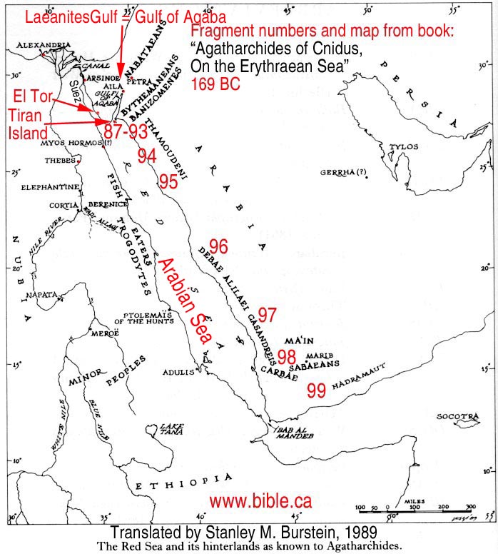
I. Map: Agatharchides of Cnidus, On the Erythraean Sea 169 BC
(Translated by Stanley M. Burstein, 1989 AD)
Note: The red numbers (87 - 99) in the map to the left, are from Burnstein's book and correspond to specific sections of text written by Agatharchides.
II. Ancient text of “On the Erythraean Sea” written in 169 BC
A. Entries of historic interest: the “camelopard” (Giraffe) and seaweed fisherman houses
1. 73a. In the country of the Trogodytes (Western coast of Arabian coast beside Egypt and Ethopia and possibly Midian – see Josephus Antiquities 2.259) there is also found the animal Greeks call ‘camelopard’ (Giraffe), an animal that, like its name, has in a certain sense a composite nature.' For it has the spotted coat of a leopard and is the size of a camel and very fast, and its neck is so long that it obtains its food from the tops of trees. (Agatharchides of Cnidus, On the Erythraean Sea 169 BC, translated by Stanley M. Burstein, 1989, book 5, fragment 73a. Photius 897 AD, Cod. 250.72, 455b)
2. 44a. The fourth group of Fish-eaters has dwellings of the following type. A huge mound of seaweed like a mountain has been built up from all eternity, and this whole pile has been solidly compacted by the constant heavy pounding of the waves so that it does not slide at all, since its mass is uniform and of one nature because of the mixing and blending with the sand. They excavate chambers the height of a man for themselves. The section at the top of the mound they leave undisturbed to serve as a sturdy roof, but below they make long tunnels which everywhere intersect. They make a small opening for light on the windward side and live quietly in the galleries. But when the tide comes in, they prepare for the hunt in the manner already described. (Agatharchides of Cnidus, On the Erythraean Sea 169 BC, translated by Stanley M. Burstein, 1989, book 5, fragment 44a. Photius 897 AD, Cod. 250.44, 450b)
B. Straits of Tiran, Tiran Island, El Bad/Midian, Nabateans, Petra, Wilderness of Shur, second Red Sea crossing camp:
1. Immediately adjacent to the Straits of Tiran: Entry 87: Fragments a,b
a. 87a. But we shall take up the remaining portion, the opposite shore which joins Arabia (south of Gulf of Aqaba in Midian), and describe it, beginning again from the innermost recess. This is named Poseideion (near Midian on Gulf of Aqaba) and was founded by Ariston, who was dispatched by Ptolemy to explore Arabia as far as the ocean and established there an altar dedicated to Poseidon Pelagaeus. Immediately after the innermost recess is a place by the sea which is exceptionally highly regarded by the natives because of the benefit derived from it. The place is named Palm-Grove, and it contains an abundance of this kind of tree which is extraordinarily fruitful and particularly conducive to pleasure and luxury. All the nearby surrounding country, however, lacks springs and is fiery hot because of its southern orientation. For this reason the barbarians rightly designated as sacred the place that supports trees and that, although situated in the midst of the most desolate regions, supplied their food. For not a few springs and streams emerge in it that are not inferior in their coldness to snow. These make the land on either side of them green and pleasant in every way. There is also an ancient altar that is made of hard stone and bears an inscription in lettering that is archaic and unintelligible. The sanctuary is cared for by a man and a woman who occupy their sacred office for life. The inhabitants of this place are long-lived and make their beds in the trees because of their fear of wild animals. (Agatharchides of Cnidus, On the Erythraean Sea 169 BC, translated by Stanley M. Burstein, 1989, book 5, fragment 87a. Diodorus 49 BC, 3.42.1-4)
b. Note: Strabo quotes Artemidorus of Ephesus in 100 BC, who in turn had quoted Agatharchides of Cnidus.
c. 87b. After saying these things about the Trogodytes (Egyptian/Ethiopian side of Arabian Gulf) and the neighbouring Aithiopians, Artemidorus [of Ephesus – 100 BC] turns to the Arabs, and describes first the Arabs who border on the Arabian gulf and are located opposite the Trogodytes (Egyptian/Ethiopian side of Arabian Gulf), beginning from Poseidion [in Midian]. He says that this place is located further in than the Aelanites Gulf [of Aqaba]. Adjacent to Poseidion is a palm grove that is well-watered and is highly valued because the whole surrounding area is fiery hot, waterless and shadeless, but the fertility of the palms there is remarkable. A man and woman watch over the grove. They are appointed on a hereditary basis, wear skins and derive their sustenance from the palms. They build huts in the trees and sleep in them because of the numerous wild animals. (Agatharchides of Cnidus, On the Erythraean Sea 169 BC, translated by Stanley M. Burstein, 1989, book 5, fragment 87b. Strabo 15 AD, 16.4.18, C776)
d. “Having given this account of the Troglodytæ and of the neighbouring Ethiopians, Artemidorus returns to the Arabians. Beginning from Poseidium, he first describes those who border upon the Arabian Gulf, and are opposite to the Troglodytæ. He says that Poseidium is situated within the bay of Heroopolis [Gulf of Suez], and that contiguous to Poseidium is a grove of palm trees, well supplied with water, which is highly valued, because all the district around is burnt up and is without water or shade. But there the fertility of the palm is prodigious. A man and a woman are appointed by hereditary right to the guardianship of the grove. They wear skins, and live on dates. They sleep in huts built on trees, the place being infested with multitudes of wild beasts.” (Strabo Geography 16.4.18, translated by H. C. Hamilton, 1903 AD)
e. While normally the Troglodytes are described as inhabiting the Egyptian and Ethiopian western shores of the Arabian Gulf, Josephus said that Midian was where the Troglodytes lived: “For that country having but little water, the shepherds used to seize on the wells before others came, lest their flocks should want water and lest it should be spent by others before they came. There were now come, therefore, to this well seven sisters that were virgins, the daughters of Raguel, a priest, and one thought worthy by the people of the country of great honor. (259) These virgins, who took care of their father’s flocks, which sort of work it was customary and very familiar for women to do in the country of the Troglodytes, they came first of all, and drew water out of the well in a quantity sufficient for their flocks, into troughs which were made for the reception of that water; (260) but when the shepherds came upon the maidens, and drove them away, that they might have the command of the water themselves, Moses, thinking it would be a terrible reproach upon him if he overlooked the young women under unjust oppression.” (Josephus Antiquities 2.258–260)
2. 88. The portion of the interior that is visible from the Palm-Grove is filled with rocky peaks of various heights, but the part that extends towards the sea is narrow and long. (Agatharchides of Cnidus, On the Erythraean Sea 169 BC, translated by Stanley M. Burstein, 1989, book 5, fragment 88. Photius 897 AD, Cod. 250.86, 457a)
3. Entry 89, fragments a,b,c
a. 89a. Adjacent to the coast just mentioned is a region people have named Duck Country because of the abundance of these creatures. Duck Country [Island of Tiran] itself lies near a very thickly wooded promontory [peninsula]. If one sights along a straight line drawn through it, the line would extend to the so-called Rock [Petra] and Palestine to which the Gerrhaeans, Minaeans and all the Arabs, whose settlements are nearby, bring frankincense, as is the report, together with cargoes of incense from the upper country. (Agatharchides of Cnidus, On the Erythraean Sea 169 BC, translated by Stanley M. Burstein, 1989, book 5, fragment 89a. Photius 897 AD, Cod. 250.87, 457a-457b)
b. 89b. After sailing past the Palm-Grove one encounters near a promontory of the mainland an island which has been named Seal Island [Tiran Island] from the animals that live on it. For so great a number of these animals frequent these places that observers were amazed. The promontory [peninsula], which is situated in front of the [Tiran] island, lies below [south] the area called the Rock [Petra] and Palestine. It is to this region that the Gerrhaeans and Minaeans bring, as is the report, frankincense and other aromatic products from what is called upper Arabia. (Agatharchides of Cnidus, On the Erythraean Sea 169 BC, translated by Stanley M. Burstein, 1989, book 5, fragment 89b. Diodorus 49 BC, 3.42.5)
c. 89c. Next in order is Seal Island [Tiran Island] which is named from the abundance of these animals. Near this island is a promontory which stretches towards the Rock [Petra] of the Arabs called Nabataeans and the country of Palestine. To this region the Minaeans, Gerrhaeans and all their neighbours bring cargoes of aromatic substances. (Agatharchides of Cnidus, On the Erythraean Sea 169 BC, translated by Stanley M. Burstein, 1989, book 5, fragment 89c. Strabo 15 AD, 16.4.18, C776)
4. Entry 90, fragments a,b
a. 90a. In former times the Maranitae occupied the next section of the coast, but later the Garindanes, who were their neighbours. The Garindanes gained control of the country in the following manner. During a festival that was celebrated every four years in the Palm Grove, which was described earlier, the neighbouring peoples would come from every direction to sacrifice in the sanctuary hecatombs of finely reared camels to the gods and, in addition, also to bring back to their homelands some of the water from it because of a tradition that a drink of it brings good health to those who make use of it. When, therefore, the Maranitae had gone to the festival for these reasons, the Garindanes slaughtered those who had been left behind in the country and then ambushed and wiped out those who were returning from the festival. Having thus emptied the country of its inhabitants, they divided up the plains which were fertile and produced rich pasturage for their flocks. This coast has few harbours and is broken up by numerous large mountains which, as they have a variety of colours, furnish an amazing sight to those sailing by it. After sailing past this country, one encounters the Laeanites Gulf [Gulf of Aqaba] around which there are many villages [Al-Bad/Midian] of the so-called Nabataean Arabs. They occupy much of the coast and not a little of the adjacent country which extends into the interior and contains a population that is unspeakably great as well as herds of animals that are unbelievably numerous. In ancient times they led a just life and were satisfied with the livelihood provided by their flocks, but later, after the kings in Alexandria had made the gulf [of Aqaba] navigable for merchants, they attacked those who suffered shipwreck. They also built pirate vessels and plundered sailors, imitating the ferocity and lawlessness of the Tauri in the Pontus. But later they were caught at sea by quadriremes and properly punished. (Agatharchides of Cnidus, On the Erythraean Sea 169 BC, translated by Stanley M. Burstein, 1989, book 5, fragment 90a. Diodorus 49 BC, 3.43.1-5)
b. 90b. Then there is another stretch of coast, formerly called the land of the Maranitae, some of whom were farmers and some tent-dwellers, but now that of the Garindanes who destroyed the former people by treachery. For they attacked and killed some of them while they were conducting a certain festival that was celebrated every four years. They also set on and utterly destroyed the rest of the people. Then there is the Aelanites Gulf [Aqaba] and Nabataea, a land that is populous and rich in pasturage. These people also inhabit the nearby offshore islands. Formerly, they were peaceful, but later they began to use rafts to plunder those sailing from Egypt. They paid the penalty for this, however, since a fleet attacked and ravaged their country. (Agatharchides of Cnidus, On the Erythraean Sea 169 BC, translated by Stanley M. Burstein, 1989, book 5, fragment 90b. Strabo 15 AD, 16.4.18, C777)
5. Wilderness of Shur: Entry 91, fragments a,b,c
a. 91a. After what is called the Laeanites Gulf [of Aqaba], around which Arabs live, is the land of the Bythemaneans. It is a large plain, all of which is well watered and lush with vegetation, albeit only dog's tooth grass, lucerne and lotus as tall as a man. All crops are restricted to this, and people cultivate nothing else. For this reason there are many wild camels in the plain and numerous herds of antelope and gazelles, many flocks of sheep and untold numbers of onagers and cattle. Joined to these advantages, however, is a countervailing evil since the region abounds with lions, wolves and leopards so that the natural bounty of the land is the cause of misfortune for its inhabitants. (Agatharchides of Cnidus, On the Erythraean Sea 169 BC, translated by Stanley M. Burstein, 1989, book 5, fragment 91a. Photius 897 AD, Cod. 250.89, 457b)
c. 91c. Next there is a plain that is well-wooded, copiously supplied with water and full of grazing animals of all sorts including onagers. Wild camels, deer and gazelles also abound in it together with numerous lions, leopards and jackals. Further, an island called Dia lies offshore. (Agatharchides of Cnidus, On the Erythraean Sea 169 BC, translated by Stanley M. Burstein, 1989, book 5, fragment 91c. Strabo 15 AD, 16.4.18, C777)
6. Entry 92, fragments a,b,c
a. 92a.Next after this section of the coast is a bay which extends into the interior of the country for a distance of not less than five hundred stades. Those who inhabit the territory within the gulf are called Batmizomaneis and are hunters of land animals. (Agatharchides of Cnidus, On the Erythraean Sea 169 BC, translated by Stanley M. Burstein, 1989, book 5, fragment 92a. Photius 897 AD, Cod. 250.90, 457b)
b. 92b. Sailing past these plains one encounters a bay which is of a paradoxical character. For it narrows to a point as it penetrates into the heart of the country. In length it extends for five hundred stades and is bounded on all sides by cliffs of amazing size. Its mouth is twisting and difficult of egress for a rock, which juts out to sea, blocks the entrance and make it impossible to sail in or out of the gulf. Further, when the current increases and the winds change, waves crash on the rocky shore and create eddies everywhere around the projecting rock. The people who inhabit the country beside the gulf, who are named the Banizomenes, support them-selves by hunting and eating the flesh of land animals. A very sacred temple has been established there which is highly revered by all the Arabs. (Agatharchides of Cnidus, On the Erythraean Sea 169 BC, translated by Stanley M. Burstein, 1989, book 5, fragment 92b. Diodorus 49 BC, 3.44.1-2)
c. 92c. Then there is a bay, about five hundred stades in extent, encircled by mountains and with an entrance that is difficult to penetrate. Men who hunt wild land animals live around it. (Agatharchides of Cnidus, On the Erythraean Sea 169 BC, translated by Stanley M. Burstein, 1989, book 5, fragment 92c. Strabo 15 AD, 16.4.18, C777)
7. Entry 93, fragments a,b,c
a. 93a. Off shore from the territory just mentioned lie three islands which create numerous harbours. The first of these islands is named the Shrine of Isis, the second Soukabya and the third Salydo. All are uninhabited and densely covered with olive trees, not, however, the kind that grows in our countries but that native to these places. (Agatharchides of Cnidus, On the Erythraean Sea 169 BC, translated by Stanley M. Burstein, 1989, book 5, fragment 93a. Photius 897 AD, Cod. 250.91, 457b)
b. 93b. Immediately after the stretch of coast just described are three offshore islands which provide numerous harbours. Historians record that the first of these is sacred to Isis. It is deserted but there are found on it stone foundations of ancient houses and steles inscribed with barbarian characters. The other islands are likewise also deserted, but they all are overgrown with olive trees that differ from those found in our countries. (Agatharchides of Cnidus, On the Erythraean Sea 169 BC, translated by Stanley M. Burstein, 1989, book 5, fragment 93b. Diodorus 49 BC, 3.44.3)
c. 93c. Then there are three uninhabited islands that are full of olive trees, not those found in our countries but a local variety which we call Aithiopian, the gum of which, moreover, has medicinal power. (Agatharchides of Cnidus, On the Erythraean Sea 169 BC, translated by Stanley M. Burstein, 1989, book 5, fragment 93c. Strabo 15 AD, 16.4.18, C777)
C. Arabian east coast of Red Sea:
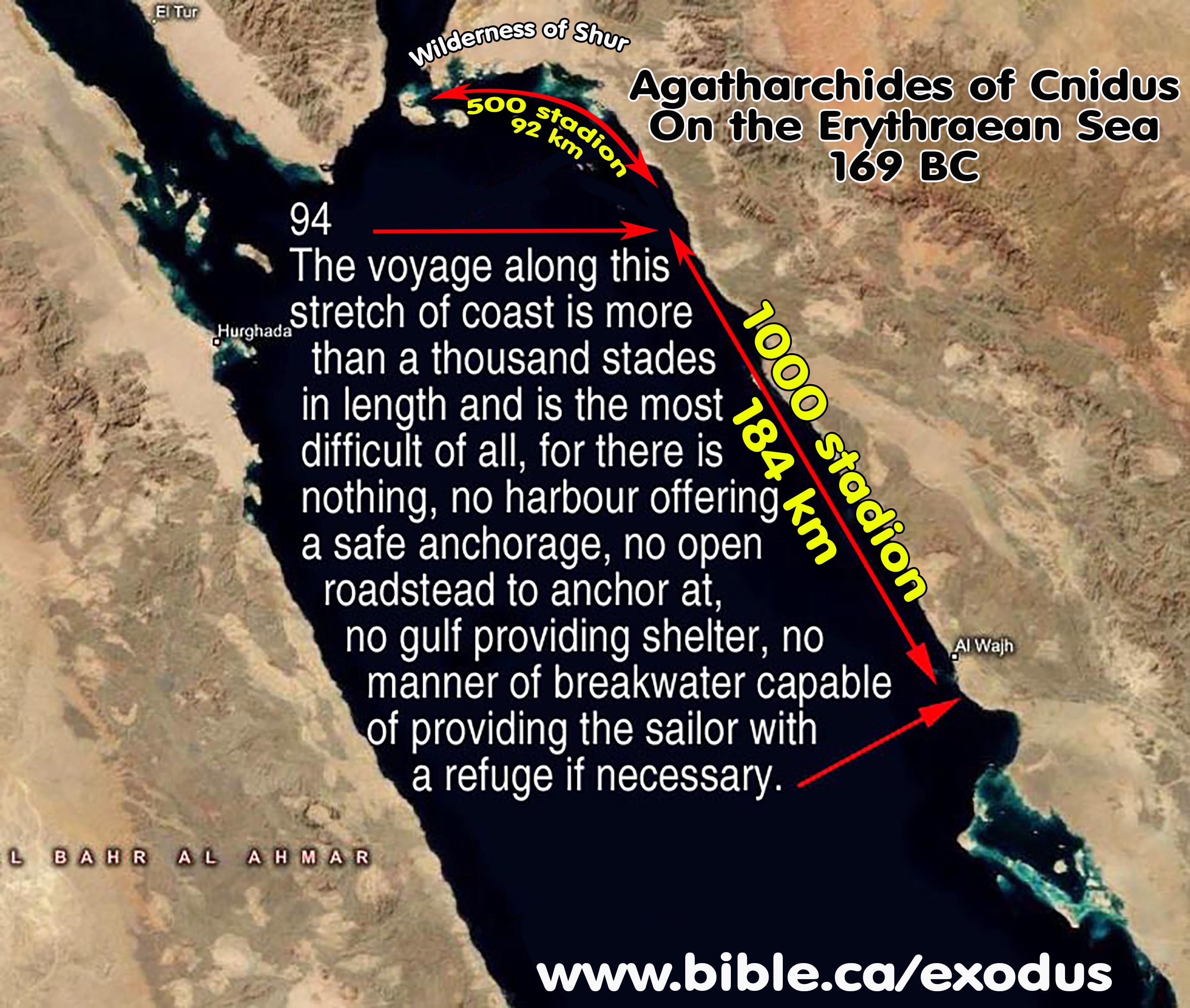
1. Entry 94, fragments a,b,c
a. 94a. After these offshore islands one can see a rocky and long stretch of coast. It is the territory of the Thamoudeni Arabs. The voyage along this stretch of coast is more than a thousand stades in length and is the most difficult of all, for there is nothing, no harbour offering a safe anchorage, no open roadstead to anchor at, no gulf providing shelter, no manner of breakwater capable of providing the sailor with a refuge if necessary. (Agatharchides of Cnidus, On the Erythraean Sea 169 BC, translated by Stanley M. Burstein, 1989, book 5, fragment 94a. Photius 897 AD, Cod. 250.92, 457b)
b. 94b. After these islands the shore is full of sheer cliffs and difficult to sail along for a thousand stades. For there exists neither harbour nor roadstead for ships to anchor at and no breakwater to furnish needed shelter to sailors in distress. (Agatharchides of Cnidus, On the Erythraean Sea 169 BC, translated by Stanley M. Burstein, 1989, book 5, fragment 94b. Diodorus 49 BC, 3.44.4)
c. 94c. Next is a rocky shore and after it a section of coast extending for about a thousand stades that lacks harbours and anchorages and is rough and difficult to sail along. For a rugged and high mountain stretches along it. Then rocky cliffs reach the sea and present a danger for which there is no recourse, especially at the time of the etesian winds and the storms that occur at that time. (Agatharchides of Cnidus, On the Erythraean Sea 169 BC, translated by Stanley M. Burstein, 1989, book 5, fragment 94c. Strabo 15 AD, 16.4.18, C777)
D. Arabian eastern Coast of Red Sea: Seaport
1. Entry 95, fragments a,b,c
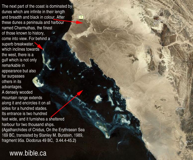
a. 95a. A mountain range with sheer and frighteningly high rocks on its summits runs along this coast. At its base there are numerous sharp rocks in the sea, and behind them are ravines which have been eaten away from below and are twisted in shape. As these are interconnected and the sea is deep, the tide when it comes in and when it rushes back gives off a sound like a great thunder clap. The surf crashing in on the enormous rocks rises on high and produces an amazing amount of foam. Again when the tide is swallowed up in the hollows, it agitates the water so terrifyingly that those who unwillingly approach these spots almost suffer a premature death because of their terror. This coast, then, is occupied by the Arabs called Thamoundeni. A good sized gulf occupies much of the next segment of the coast. Scattered islands lie off it which are in appearance similar to the Echinades. The next part of the coast is dominated by dunes which are infinite in their length and breadth and black in colour. After these dunes a peninsula and harbour named Charmuthas, the finest of those known to history, come into view. For behind a superb breakwater, which inclines towards the west, there is a gulf which is not only remarkable in appearance but also far surpasses others in its advantages. A densely wooded mountain range extends along it and encircles it on all sides for a hundred stades. Its entrance is two hundred feet wide, and it furnishes a sheltered harbour for two thousand ships. In addition to these advantages it has an extremely good supply of fresh water since a large river flows into it. Also in the middle of the gulf there is an island which has a good supply of fresh water and is able to support gardens. In general it is very similar to the harbour at Carthage which is called Cothon. A multitude of fish from the sea congregate in it because of its calmness and the sweetness of the waters that flow into it. After sailing past these places five mountains, separate from one another, rise on high. Their peaks narrow to rocky knolls, producing an appearance similar to the pyramids in Egypt. Next is a circular gulf which is enclosed by large promontories. A trapezoidal shaped hill lies midway along a diagonal line drawn through the gulf. On the hill three temples, remarkable for their height, have been built for gods which are unknown to the Greeks but highly honoured by the natives. (Agatharchides of Cnidus, On the Erythraean Sea 169 BC, translated by Stanley M. Burstein, 1989, book 5, fragment 95a. Diodorus 49 BC, 3.44.4-45.2)
b. 95b. Next is a gulf with scattered islands and in succession three extremely high dunes of black sand. After these is the harbour of Charmothas which is a hundred stades in circumference and has an entrance that is narrow and dangerous for all kinds of craft. A river also flows into it, and in the middle is an island that is well-wooded and suitable for cultivation. (Agatharchides of Cnidus, On the Erythraean Sea 169 BC, translated by Stanley M. Burstein, 1989, book 5, fragment 95b. Strabo 15 AD, 16.4.18, C777)
E. Arabian eastern Coast of Red Sea: Modern Mecca

1. Entry 96, fragments a,b
a. 96a. MECCA AREA: After this segment of coast, not, however, immediately after it but some distance beyond, is an extremely well-watered stretch of coast and the mountain that is called Laemus. Its perimeter is indescribably great in extent, and it is covered over with trees of all kinds. (Agatharchides of Cnidus, On the Erythraean Sea 169 BC, translated by Stanley M. Burstein, 1989, book 5, fragment 96a. Photius 897 AD, Cod. 250.94, 457b)
b. 96b. MECCA AREA: After these places is a damp stretch of coast that it is intersected by streams of sweet water that flow from springs. In this section of the coast there is a mountain called Chabinus which is overgrown with thickets of all kinds. (Agatharchides of Cnidus, On the Erythraean Sea 169 BC, translated by Stanley M. Burstein, 1989, book 5, fragment 96b. Diodorus 49 BC, 3.45.3)
2. Entry 97, fragments a,b,c
a. 97a. The Debae inhabit the region that borders on the mountainous district. Some are nomads and some are farmers. Through the middle of their country flows a river that is tripartite in nature. It carries down gold nuggets that are so obviously abundant that the mud that is deposited at its mouths gleams from afar. The inhabitants of this region are unskilled in working this sort of metal. They are extremely hospitable to strangers, not, however, to all men but to those who come to them from the Peloponnesus and Boeotia because of some mythical tale about Heracles. (Agatharchides of Cnidus, On the Erythraean Sea 169 BC, translated by Stanley M. Burstein, 1989, book 5, fragment 97a. Photius 897 AD, Cod. 250.95, 457b-458a)
b. 97b. The land bordering the mountainous area is inhabited by Arabs who are called Debae. They are camel raisers who rely on this beast for all the most important necessities of life. They fight against their enemies from these animals, and they easily accomplish all their business by transporting their wares loaded on their backs. They live by drinking their milk, and they roam their whole country on racing camels, A river runs through the middle of their country which carries down so many nuggets of gold that the silt which is deposited at its mouths gleams. The natives are completely without experience in the working of gold, but they are hospitable to strangers, not to all visitors, however, but only to those from Boeotia and the Peloponnesus because of some ancient bond of kinship derived from Heracles with this people, which they say has been handed down in mythical form from their ancestors. (Agatharchides of Cnidus, On the Erythraean Sea 169 BC, translated by Stanley M. Burstein, 1989, book 5, fragment 97b. Diodorus 49 BC, 3.45.3-5)
c. 97c. Then, there is a rugged stretch of coast, and after it some gulfs and the territory of nomads, who base their way of life on camels. For they conduct war from these animals, travel on them and are nourished with their milk and eat their flesh. A river flows through their country that brings down particles of gold, but they do not know how to refine gold. They are called Debae, some of them are nomads and some farmers. (Agatharchides of Cnidus, On the Erythraean Sea 169 BC, translated by Stanley M. Burstein, 1989, book 5, fragment 97c. Strabo 15 AD, 16.4.18, C777)
3. Entry 98, fragments a,b,c
a. 98a. The Alilaei and Casandreisi are neighbours of these people, and they possess a country that is not at all similar to those just described. For the air is neither cool nor dry nor fiery hot but is characterized by soft and thick clouds from which come even in summer rain storms and gentle showers. 2 Most of the land is very fertile, but not all of it is cultivated since the people are comparatively inexperienced. They do, however, mine gold in the land's underground strata and discover a great amount, not the sort that must be smelted from ore with knowledge and skill but the kind that occurs naturally and is called `unfired' by Greeks because of this fact. The smallest nugget of this kind of gold is the size of an olive pit, the mid-sized nugget that of the stone of a medlar and the largest is comparable to a walnut. They wear around their wrists and necks bands consisting of perforated gold nuggets alternating with transparent stones. They bring these to their neighbours and sell them cheaply, for they exchange bronze for three times its weight in gold and iron for twice its weight in gold. Silver is worth ten parts of gold since value is deter-mined by abundance and scarcity.' In such matters all life considers not nature but need. (Agatharchides of Cnidus, On the Erythraean Sea 169 BC, translated by Stanley M. Burstein, 1989, book 5, fragment 98a. Photius 897 AD, Cod. 250.96, 458a)
b. 98b. The next region is inhabited by the Alilaei and Gasandi Arabs. It is not fiery hot like the nearby countries but is often covered with soft and dense clouds. From these come rains and gentle showers that make the summer season temperate. The land is extremely fertile and of exceptional quality, but it is not cultivated to its potential be-cause of the inexperience of the people. But they do find gold in natural galleries under the earth and collect a great amount of it, not the sort which is fused together from melted gold dust but native gold, and because of this circumstance it is called `unfired' As for the size of the nuggets, the smallest is found to approximate a fruit pit and the largest is not much smaller than a walnut. On their wrists and around their necks they wear this sort of gold, having bored a hole through it and strung it in alternation with transparent stones. As this kind of gold is abundant in their country and bronze and iron are rare, they exchange these goods with merchants on an equal basis. (Agatharchides of Cnidus, On the Erythraean Sea 169 BC, translated by Stanley M. Burstein, 1989, book 5, fragment 98b. Diodorus 49 BC, 3.45.6-8)
c. 98c. Next is a people, who are more civilized people than the Debae and inhabit a country with a more temperate climate since it is both well-supplied with water and receives adequate rainfall. Gold is mined in their country, not particles, but gold nuggets requiring little refining, the smallest of which is the size of a fruit pit, the middle sized ones that of a medlar and the largest that of a walnut. They perforate them and make collars by stringing them on thread in alternation with transparent stones, and wear these around their necks and wrists. They also sell their gold to their neighbours cheaply, exchanging it at a rate of three to one for copper and two to one for silver both because of their inexperience in the working of gold and the scarcity of the metals for which it is exchanged, the need for which in their life is more pressing. (Agatharchides of Cnidus, On the Erythraean Sea 169 BC, translated by Stanley M. Burstein, 1989, book 5, fragment 98c. Strabo 15 AD, 16.4.18, C777-778)
4. Entry 99, fragments a,b,c
a. 99a. The Carbae occupy the region immediately after these people. Then follows a deep water harbour into which empty several springs. Immediately adjacent is the tribe of the Sabaeans, the greatest of the peoples in Arabia and the possessors of every sort of good fortune... (Agatharchides of Cnidus, On the Erythraean Sea 169 BC, translated by Stanley M. Burstein, 1989, book 5, fragment 99a. Photius 897 AD, Cod. 250.97, 458a-458b)
b. 99b. After these peoples are those called Carbae and after them the Sabaeans who are the most populous of the Arab peoples. They inhabit the region called Eudaemon Arabia which bears most of the products considered valuable by us. It also supports herds of animals of all kinds in untold abundance... (Agatharchides of Cnidus, On the Erythraean Sea 169 BC, translated by Stanley M. Burstein, 1989, book 5, fragment 99b. Diodorus 49 BC, 3.46.1-5)
c. 99c. Immediately adjacent is the very fertile country of the Sabaeans, a very large tribe, in whose territory are found myrrh, frankincense and cinnamon. On the coast there is also found balsam and a certain other very fragrant herb, the odour of which, however, quickly fades. (Agatharchides of Cnidus, On the Erythraean Sea 169 BC, translated by Stanley M. Burstein, 1989, book 5, fragment 99c. Strabo 15 AD, 16.4.19, C778)
By Steve Rudd: Contact the author for comments, input or corrections.
