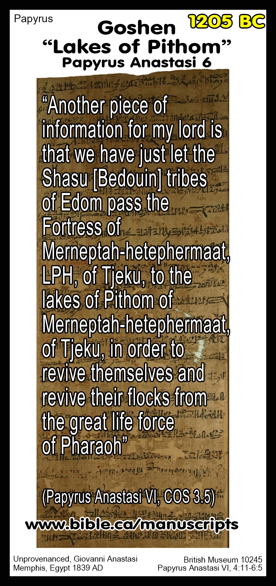
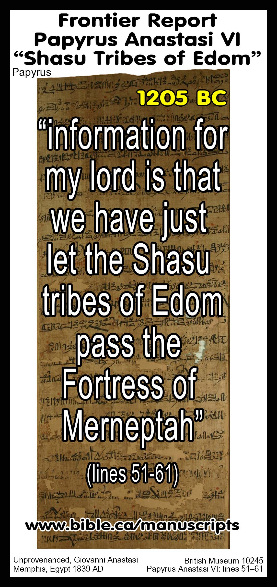
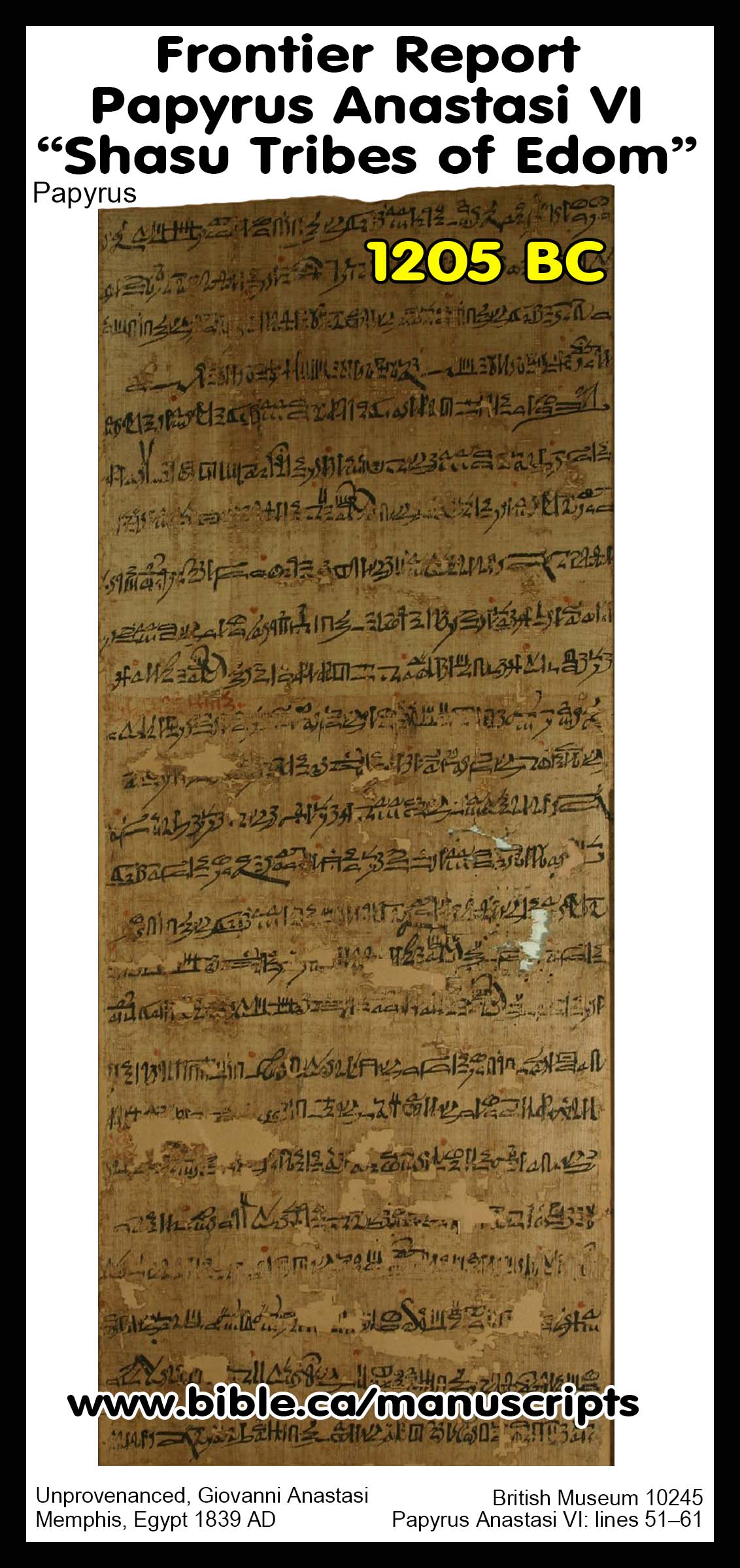
Papyrus Anastasi VI mentions the “Lakes of Pithom” and "Bedouin tribes of Edom"
|
Lakes of Pithom in Goshen:
Translation of Papyrus Anastasi 6:
“Another piece of information for my lord is that we have just let the Shasu [Bedouin] tribes of Edom pass the Fortress of Merneptah-hetephermaat, LPH, of Tjeku, to the lakes of Pithom of Merneptah-hetephermaat, of Tjeku, in order to revive themselves and revive their flocks from the great life force of Pharaoh” (Papyrus Anastasi VI, COS 3.5) |
|
|
Digging up Bible stories!
“Lakes of Pithom” in Goshen
"We have finished letting the Bedouin tribes of Edom pass the Fortress."
Detailed outline on Edom.
|

Introduction:
- The Papyrus Anastasi VI dates to 1205 BC (the 8th year of Merneptah) and is one of several manuscripts purchased around 1839 AD from an Armenian antiquity dealer named Giovanni Anastasi (1765-1860).
- Lakes of Pithom not pools of Pools at Goshen:
![]()
- There are two ancient literary sources that describe the lakes of Goshen at Pithom in the Wadi Tumilat: Papyrus Anastasi 4 and Papyrus Anastasi 6.
- Papyrus Anastasi 6: “The modern translation influenced by Hebrew בְּרֵכוֹת “pools” or “water reservoirs” must be assumed wrong, not only because of the paleoenvironment explained above. In the onomastic Papyrus Golenischeff 1.9–10 the b-r-k-A-w.t are associated with and directly follow the expression nwy “wave” (Wo¨rterbuch, lemma no. 56570, DZA 22.903.660). What is more, the Demotic Fayum Papyrus (Papyruszettel 7 or 7a) mentions a toponym b-r-g-t with the compound classifiers of a channel signifying a stretch of water and the town. It has been pinpointed as a habitat of the crocodile and is most probably the precursor of the Birket Qarun in the Fayum (DZA 22.903.700). A pool is significant neither for making distinct waves nor as a habitat for crocodiles. I would venture to translate this loanword, as in the Arabic “birka,” as a lake, and thus a larger body of water, as paleogeographic studies have shown for the western portion of Wadi Tumilat.” (On the Historicity of the Exodus: What Egyptology Today Can Contribute to Assessing the Biblical Account of the Sojourn in Egypt, Manfred Bietak, Israel's Exodus in Transdisciplinary Perspective, Editor-Thomas E. Levy, p21, fn 14, 2015 AD)
- Papyrus Anastasi 4: Uses the toponym “GSM lake” which is equated with “Goshen Lake” in the Wadi Tumilat.
- It has been suggestion that "Tjeku" be equated with Biblical Goshen.
- The fanciful notion that this is part of a collection of training letters for school boys is highly questionable and speculative and the letter should be taken at face value as a genuine field report.
- Papyrus manuscripts of this quality are exceedingly rare and to find an entire collection of school curriculum used to train children, is like winning two lottery tickets at the same time.
- The fact that there are four different letters on a single papyrus sheet is better explained as genuine field reports or first generation copies produced to assist in organizing the Royal archive in a kind of "paperwork reduction" exercise.
- These are real letters founded in real historical events and should be taken seriously as such as a window into the past on the same scale as Josephus or the Babylonian Chronicles of Nebuchadnezzar.
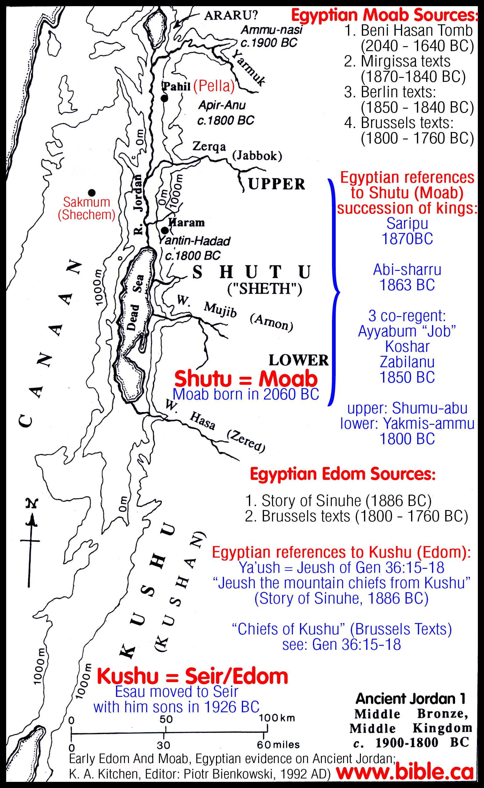
- Map of ancient Edom: (Detailed outline
on Edom)
I. Translation of Papyrus Manuscript Anastasi VI:
|
|
Translation #1 of Papyrus Anastasi 6: "Scribe Inena informing his lord, treasury scribe Kagab […] in LPH. It is word sent to let my lord know. Another information for my lord that I am doing every mission assigned me well and firm as brass. I am not being lax. Another information for my lord that we have just let the Shasu [Bedouin] tribes of Edom pass the Fortress of Merneptah-hetephermaat, LPH, of Tjeku, to the pool [lakes] of Pithom of Merneptah-hetephermaat, of Tjeku, in order to revive themselves and revive their flocks from the great life force of Pharaoh, LPH, the perfect Sun of every land, in Regnal Year 8, third epagomenal day, the birth of Seth. (5.2) I have sent them in a copy of report to where my lord is, together with the other names of days on which the Fortress of Merneptah-hetephermaat, LPH, of Tjeku, was passed […]. It is word sent to let my lord know." (A Report of Bedouin, COS 3.5, Papyrus Anastasi VI, James P. Allen, lines 4.11-5.2/51–61, 2003 AD) |
|
|
Translation #2 of Papyrus Anastasi 6:
"Some 60 or more years later, in the eighth year of Merenptah, c. 1206 BC, the term Edom appears for the first time. Papyrus Anastasi VI contains the following well-known report (lines 51-61):
"We have finished with allowing the Shasu clansfolk of Edom to pass the fort of Merenptah that is in Succoth ['Tjeku'], to the pools (brkt = lakes) of Pi-Atum [Pithom] of Merenptah that (is/are) in Succoth, to keep them alive and to keep alive their livestock, by the will of Pharaoh, LPH, the good Sun of Egypt, along with the names from the other days on which the fort of Merenptah that is in Succoth was passed [by such people...] (text, Gardiner 1937:76-77; translations, e.g. ANET:259; with notes, Caminos 1954:293)." (Early Edom And Moab, Egyptian evidence on Ancient Jordan; K. A. Kitchen, Editor: Piotr Bienkowski, 1992 AD) |
Translation #3 of Papyrus Anastasi 6:
"The Scribe Inena communicating to his lord, the Scribe of the Treasury Qa-g[abu], …:—In life, prosperity, health! This is a letter [to] let [my lord] know: An [other communication to] my lord, to wit: [I] have carried out every commission laid upon me, in good shape and strong as metal. I have not been lax. Another communication to my [lord], to [wit: We] have finished letting the Bedouin tribes of Edom pass the Fortress [of] Mer-ne-Ptah Hotep-hir-Maat—life, prosperity, health!—which is (in) Tjeku,3 (56) to the pools [lakes] of Per-Atum [Pithom] [of] Mer-[ne]-Ptah Hotep-hir-Maat, which are (in) Tjeku, to keep them alive and to keep their cattle alive, through the great ka of Pharaoh—life, prosperity, health!—the good sun of every land, in the year 8, 5 [intercalary] days, [the Birth of] Seth. I have had them brought in a copy of the report to the [place where] my lord is, as well as the other names of days when the Fortress of Mer-ne-Ptah Hotep-hir-Maat—life, prosperity, health!—which is (in) [Tj]ek[u], may be passed." (Papyrus Anastasi VI, British Museum 10245, lines 51–61, = iv ii–v 5, late Nineteenth Dynasty, end of the 13th century BC, and presumably from Memphis, ANET, p. 259)
III. Papyrus Manuscript Anastasi VI: Lakes of Pithom in Goshen:
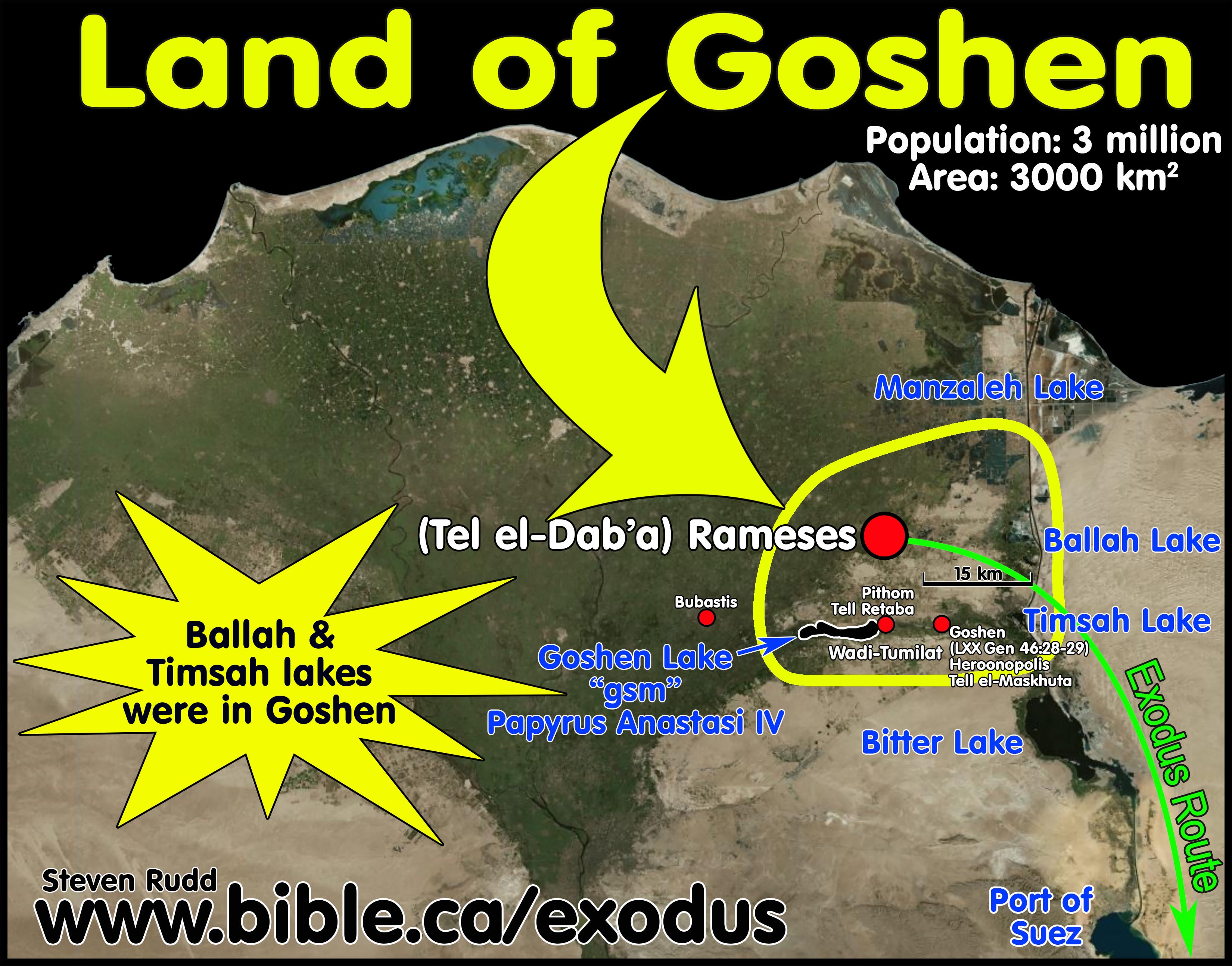
1. Goshen included Wadi Tumilat and lake Timsah:
a. “But even more conclusive than this is the situation in Goshen during the reign of Thutmose III as compared to that which existed under Rameses II. In the time of Rameses, some of his main building activity was right in the region of Wadi Tumilat, or Goshen, and this meant that Egyptians must have been living all around this region and in the midst of it as well. But the details of the plagues of flies, of hail, and of darkness (Ex. 8:22; 9:25–26; 10:23) make it clear enough that Goshen was at the time of the Exodus inhabited almost exclusively by the Hebrews, and plagues which befell the rest of Egypt made no appearance at all in Goshen. So far as we can tell from the archaeological evidence presently at hand, there were no Egyptians living there during the reign of Thutmose.” (A Survey of Old Testament Introduction, Gleason Archer, p246, 1994 AD)
b. “Leaving the Negeb at Beer-sheba (Gen. 46:1), Jacob and his sons journeyed across the Sinai entering Egypt near Succoth in the Wadi Tumilat. Asiatic shepherds and merchants coming from southern Canaan and Transjordan used this route extensively. The family entered the “land of Goshen” (Gen. 46:28; 47:6), once anachronistically called the “land of Rameses” (Gen. 47:11), located in the northeastern Delta of Egypt. Some scholars have identified Goshen more specifically with the Wadi Tumilat, a fertile finger of the Delta jutting out into the Sinai Desert.” (Holman Bible Atlas, p50, 1998 AD)
c. “The Septuagint clearly identified the land of Goshen and the route of the Exodus with the Wadi Tumilat. … Another interpretation of the Exodus route in the Septuagint (Exod. 1:11)—originally most likely to be a gloss that found its way into the main text—seems to lead from Heliopolis, thought to be Pithom (Pi-Atum), to the Gulf of Suez and the Red Sea.” (On the Historicity of the Exodus: What Egyptology Today Can Contribute to Assessing the Biblical Account of the Sojourn in Egypt, Manfred Bietak, Israel's Exodus in Transdisciplinary Perspective, Editor-Thomas E. Levy, p21, 2015 AD)
d. “During prehistoric times (before 3200 BC), the Nile’s easternmost branch once passed through the Wadi Tumilat. Stretching 31 mi (52 km) from just west of modern Zagazig (ancient Bubastis) to Ismailiya (on Lake Timsah), it created a portion of the eastern edge of the Nile delta. While the course of this delta branch disappeared in historic times, and the present eastern branch is significantly further to the west, both historical and archaeological evidence indicate that ancient canals were cut from the Nile River eastward through the Wadi Tumilat. This ancient watercourse apparently continued to flood periodically throughout history with the overflow of the Nile’s annual flooding. Thus, the Wadi Tumilat may have been one of the reasons that the Isthmus of Suez became known for its marshy fresh water lakes and associated “reeds” (twf). The Wadi Tumilat was no doubt part of the Biblical Land of Goshen.” (New Evidence From Egypt on the Location of the Exodus Sea Crossing, Gary Byers, Bible and Spade, p19, 2006 AD)
e. “There are areas at the eastern borders of Egypt that had Semitic toponyms used even by Egyptian scribes. This situation can only be reasonably explained by assuming that Semitic-speaking people inhabited such areas during the New Kingdom. One has to mention particularly in this respect Wadi Tumilat, which would fulfill in every respect the model of the land of Goshen (or the land of Ramses) in the Bible.” (On the Historicity of the Exodus: What Egyptology Today Can Contribute to Assessing the Biblical Account of the Sojourn in Egypt, Manfred Bietak, Israel's Exodus in Transdisciplinary Perspective, Editor-Thomas E. Levy, p30, 2015 AD)
2. Goshen was centered at “Lake Goshen” or the “Lakes of Pithom” in the Wadi Ṭumilât:
a. “One wonders if under such evidence Wadi Tumilat could not be deemed, with all due reservation, a paradigm for the biblical scenario of the land of Goshen (Gen. 45:10; 46:28–29, 34; 47:1, 4, 6, 27; 50:8; Exod. 8:18; 9:26). Indeed, Sarah I. Groll cautiously postulated the identification of a possible Egyptian rendering of the biblical toponym Goshen in Papyrus Anastasi IV (1b:1–2) referring to a stormy lake by the name of gsm in association with waves. This name gsm seems to have been used as a toponym and is considered to have been most probably a Semitic loanword. It is in this connection that it is most important to note that, in the Septuagint translation of the Pentateuch into Greek, this name seems to be retained as Γεσεμ (Gesem). The lake must have been a wide stretch of water. This would fit in perfectly with the western part of Wadi Tumilat with its large overflow lake.” (On the Historicity of the Exodus: What Egyptology Today Can Contribute to Assessing the Biblical Account of the Sojourn in Egypt, Manfred Bietak, Israel's Exodus in Transdisciplinary Perspective, Editor-Thomas E. Levy, p21, 2015 AD)
b. “The Israelites were settled in the Land of Goshen, in a region which perhaps extended further northward, but which certainly comprehended the Wadi Tumilât, wherein was situate the city of Pithom, where, according to the Septuagint, Jacob and Joseph met when the Patriarch came to Egypt.” (The Store-City of Pithom and the Route of the Exodus, Edouard Naville, p23, 1885 AD)
3. Papyrus Anastasi 6:4.11–6.5:
a. “We have allowed the tribes of the Shasu of the land of Atuma to pass the stronghold of King Menephtah of the land of Succoth, towards the lakes of Pithom of King Menepthah of the land of Succoth, in order to feed their cattle in the great farm of Pharaoh,” (Papyrus Anastasi vi. 4)
b. “More in keeping with the biblical tradition is the oft-discussed event described in Papyrus Anastasi VI (4.11–6.5) in which a group of Shosu Bedouins from Edom is granted permission by the Egyptian authorities to pass the border stronghold in the region of Tjeku in what is today the Wadi Tumilat and to proceed with their livestock to the Lakes of Pithom to keep their flocks alive (Gardiner 1937: 76–77; Caminos 1954: 293–295; Giveon 1971: 131–134). This papyrus dates back to the end of the thirteenth century BC, more precisely to the fifth year of Sethos (Seti) II (ca. 1209 BC). These people should not be taken as Edomites, but as Shosu from Edom. As Yahweh is said to have risen in Seı¨r in Edom (Deut. 33:2; Ju. 5:4; see also Habakuk 3:3) these pastoralists appear at the right time and from the right corner to be considered the gene pool of Midianites or Proto- Israelites.17 Nevertheless the incident described in this papyrus can only be seen as a symptomatic event, recorded and preserved by accident as a template record for apprentice scribes. However, one has to wonder in this context why the toponym the “Lakes of Pithom” is referred to by Egyptian scribes with the Semitic loanword b-r-k-w.t in syllabic writing and not with its Egyptian name. This is indeed remarkable. We gain the suspicion that this word had become something of a toponym in a region inhabited long enough by a Semitics peaking population to supplant the original Egyptian name with an idiomatic expression of their own. In support of this proposition, the point needs to be made that, in the Onomasticon Amenope (Amenemopet), word no. 33 b-r-k-t is followed by no. 34 hnty(w) “borderland,” “frontier”— which would be a meaningful association. Furthermore another Semitic expression s-g-r is used for an enclosure or a fortification of a fortress in the same region (papyri Anastasi V.19, 7). Even Tjeku, the name of the region of Wadi Tumilat, is regarded by many as an Egyptian rendering of the biblical Sukkot. All of this could be viewed as some evidence that this borderland had been settled by a Semitic-speaking population.” (On the Historicity of the Exodus: What Egyptology Today Can Contribute to Assessing the Biblical Account of the Sojourn in Egypt, Manfred Bietak, Israel's Exodus in Transdisciplinary Perspective, Editor-Thomas E. Levy, p20, 2015 AD)
c. “During an investigation of the paleogeography of the Eastern Delta (Bietak 1975: 88–90) it was discovered in topographic contour maps that the western part of Wadi Tumilat, just west of Tell el-Retaba was in antiquity the basin of a large natural overflow lake of 18 km length and 1.8 km width. It must have been a stretch of water that was suitable for fishing. Only now does it become understandable why this lake was eponymous and had given its name to this region as “Eastern Harpoon Nome” (for the nomes, see Helck 1974: 172–4) from the time of the Old Kingdom onwards. This lake was fed by a side branch of the easternmost Nile branch. In late Ramesside times it seems, according to information from Papyrus Anastasi VI: 4:11–6:5, that the lake had ramified into several smaller lakes (plural b-r-k-A-w.t), most likely owing to a reduced water intake or sedimentation. The contours of the Wadi basin indeed show a separation of the lake into subunits by accumulation of ridges of sediments. The description of those waters is written with a Semitic loanword in syllabic writing: b-r-k- A-w.t. The modern translation influenced by Hebrew בְּרֵכוֹת “pools” or “water reservoirs” must be assumed wrong, not only because of the paleoenvironment explained above. In the onomastic Papyrus Golenischeff 1.9–10 the b-r-k-A-w.t are associated with and directly follow the expression nwy “wave” (Wo¨rterbuch, lemma no. 56570, DZA 22.903.660). What is more, the Demotic Fayum Papyrus (Papyruszettel 7 or 7a) mentions a toponym b-r-g-t with the compound classifiers of a channel signifying a stretch of water and the town. It has been pinpointed as a habitat of the crocodile and is most probably the precursor of the Birket Qarun in the Fayum (DZA 22.903.700). A pool is significant neither for making distinct waves nor as a habitat for crocodiles. I would venture to translate this loanword, as in the Arabic “birka,” as a lake, and thus a larger body of water, as paleogeographic studies have shown for the western portion of Wadi Tumilat. I am grateful to Orly Goldwasser from the Hebrew University in Jerusalem for helping me with the research into this loanword.” (On the Historicity of the Exodus: What Egyptology Today Can Contribute to Assessing the Biblical Account of the Sojourn in Egypt, Manfred Bietak, Israel's Exodus in Transdisciplinary Perspective, Editor-Thomas E. Levy, p21, fn 14, 2015 AD)
4.
Papyrus Anastasi 4:1b:1–2:
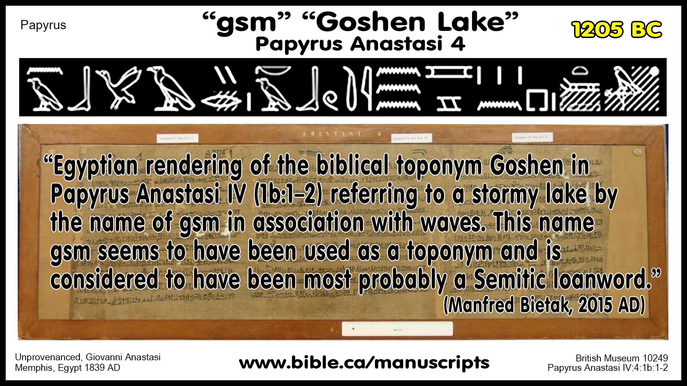
a. “One wonders if under such evidence Wadi Tumilat could not be deemed, with all due reservation, a paradigm for the biblical scenario of the land of Goshen (Gen. 45:10; 46:28–29, 34; 47:1, 4, 6, 27; 50:8; Exod. 8:18; 9:26). Indeed, Sarah I. Groll cautiously postulated the identification of a possible Egyptian rendering of the biblical toponym Goshen in Papyrus Anastasi IV (1b:1–2) referring to a stormy lake by the name of gsm in association with waves. This name gsm seems to have been used as a toponym and is considered to have been most probably a Semitic loanword. It is in this connection that it is most important to note that, in the Septuagint translation of the Pentateuch into Greek, this name seems to be retained as Γεσεμ (Gesem). The lake must have been a wide stretch of water. This would fit in perfectly with the western part of Wadi Tumilat with its large overflow lake.” (On the Historicity of the Exodus: What Egyptology Today Can Contribute to Assessing the Biblical Account of the Sojourn in Egypt, Manfred Bietak, Israel's Exodus in Transdisciplinary Perspective, Editor-Thomas E. Levy, p21, 2015 AD)
b. see also: Groll Sarah, Israelit. 1998. The Egyptian Background of the Exodus and the Crossing of the Reed Sea: A New Reading of Papyrus Anastasi VIII. In Jerusalem Studies in Egyptology, A¨ AT, vol. 40, ed. I. Shirun- Grumach, 173–192. Wiesbaden: O. Harrassowitz.
IV. Other authorities on Papyrus Manuscript Anastasi VI:
- "The earliest reference to Edom comes from Egypt, where Papyrus Anastasi VI preserves the report of an official from the reign of Merneptah (c. 1220 BC). He noted that the Bedouin tribes of Edom were trying to pass an Egyptian fortress to “the pools of Per-Atum” to keep themselves and their cattle alive. It is possible that the Semitic place name was in use as early as the fifteenth century BC, if Edom is identified with one of the place names (’i-d-má) from the list of Thutmose III (1490–1436 BC). (The Baker Illustrated Bible Dictionary, Edom, 2013 AD)
- "A reference to the Shasu in Papyrus Anastasi VI, dating to the reign of Pharaoh Merneptah (1213–1203 bc), includes a reference to place called ’A-du-ma, which Giveon interpreted as a reference to biblical Edom (Giveon, Les Bédouins, 132). The passage states: “We have completed the transfer of the Shasu tribes of ’A-du-ma (Edom?) past the fortress ‘Merneptah-hotep-her-Ma‘at, life, prosperity, and health,’ which is in Tjeku to the pools of Per-Atum of ‘Merneptah-hotep-her-Ma‘at,’ which are in Tjeku, in order to keep them alive and in order to keep their cattle alive” (Papyrus Anastasi VI, lines 51–57; Giveon, Les Bédouins, 130–34; translation adapted from Rainey and Notley, /Sacred Bridge 103)." (LBD, Shasu, 2015 AD)
- "The Papyrus Anastasi VI: 51–61, dated to the eighth year of Merneptah’s reign (1213–1203), located the shasu in Edom—the first Egyptian mention of this land. In this text, shasu clans from Edom gained permission to pass by a fortress in eastern Egypt in order to water their livestock (Weippert 1979:27; Bartlett 1989:77–79; MacDonald 1994:231–33)." (Near Eastern Archaeology, Volume 62, Nos. 1–4, p 105, 1999 AD)
- "In a group of letters which served as models for schoolboys [unlikely, see note above], one communication presents the form in which an official on the eastern frontier of Egypt might report the passage of Asiatic tribes into the better pasturage of the Delta." (Papyrus Anastasi VI, British Museum 10245, ANET 259)
- "This model letter is one of four unique scribal exercises [unlikely, see note above] compiled in a single papyrus, now in the British Museum (EA 10245). The opening protocol of the papyrus is dated to the reign of Seti II, but the regnal year mentioned in the letter translated here is probably that of his predecessor, Merneptah. The letter refers to the arrival of bedouin and their flocks from the northern Sinai desert at one of the Egyptian border fortresses erected during the Ramesside period. As such it reflects the careful control that Egypt exercised during this period on traffic in and out of the eastern Delta." (A Report of Bedouin, COS 3.5, Papyrus Anastasi VI, James P. Allen, 2003 AD)
Conclusion:
- We find evidence of the Exodus in the Hebrew toponym borrowed by the Egyptians for Lake Goshen at Wadi Tumilat.
- 150 years ago, bible scoffers chortled that Edom as a nation was "Just another Bible myth but once again the Bible is proven as a record of real history.
- What we read in the book, we find in the ground, or in this case in a papyrus manuscript that dates to 1205 BC.
By Steve Rudd: Contact the author for comments, input or corrections.
