Jerusalem Temple Mount:
The Charles Wilson and Charles Warren map collection with notes: 1864 AD
Ordinance Survey of Jerusalem by Captain Charles W. Wilson, R. E., 1886
|
|
|
|
|
Use this map as Key to Wilson and Warren's notes |
High detail map by Wilson and Warren |
3D map based upon Wilson and Warren. Numbers do not correspond to Wilson and Warren's notes. |
Actual field notes made between 1864-1871 by Charles Wilson and Charles Warren:
Key to maps: (How text corresponds to maps)
- Blue Text: is from Charles Wilson's 1864 AD "Ordnance Survey of Jerusalem".
- Black text: is Charles Warren's 1871 AD "Recovery of Jerusalem".
- In 1871 AD Charles Warren checked Charles Wilson's measurements from 7 years earlier and added his own notes which he put in his "Recovery of Jerusalem".
- Wilson used Roman Numbers (ei. Cistern No. I) correspond to the (1) on Temple Mount Map of 1864 AD which does not use roman Numerals.
- Warren's notes below Wilson's note on Cistern No. I say "Rock 2427 feet above Mediterranean". This means that the rock at Cistern No. I is 2427 feet of elevation above the Mediterranean sea.
Cistern No. I, under platform to north of the "Dome of the Rock," descended; 40 feet deep, 1 foot 6 inches of water, rectangular in shape; the southern end is raised 4 feet 6 inches above the main body of the cistern ; there are two openings in use, and one closed; no trace could be seen of any conduit entering, except the surface gutters; the roof is of masonry, and is a plain semicircular vault.
Rock 2427 feet above Mediterranean, and 12 feet below surface of Dome of the Rock platform. This tank is a tunnel about 130 feet long and 24 feet wide, cut in rock for 18 feet from bottom to springing of arch, which is segmental. Signor Pierotti describes a passage connecting this tank with a chamber under the Sakhra; and I have to suggest that this Sakhra cave is the gate Nitsots, from whence there was a passage through the tunnel to the gate Tadi.
Cistern No. II, under platform to north-east of the "Dome of the Rock," 47 feet 6 inches deep, 5 feet 8 inches of water; not visited, but apparently of large size.
Rock 2429; 6 feet from surface. This is a large tank cut in rock, but there was too much water in it for us to measure it. Length about 60 feet; breadth about 50 feet. The sheikh of the Mosque said it communicated with No. 34 hard by; but it does not appear to do so.
Cistern No. III, under platform to north-west of the "Dome of the Rock," 32 feet deep, 1 foot of water but deeper in western chamber, which could not be explored. The main cistern is divided by a wall of barely built masonry, of which a good deal of the cement has fallen, and through which there is a communication between the two chambers by a low-arched doorway; there are two openings in use, at the south-west corner a channel cut in the rock as noticed coming into the cistern, but it could not be reached; the roof of the southern portion is of rock, but the northern chambers are covered with elliptical, almost pointed, vaults.
Rock 2426 feet; 9 feet from surface. A channel cut in the rock, leading into this tank, was examined November, 1867; it runs north and south, and conducts into the tank surface water from small ducts which run east and west. There are three chambers in this tank, which are separated by piers, through which there are low-arched doorways. I have to suggest that this may have been the House of Baptism, communicating with the room of Beth Mokad and the gate Tadi.
It is to be noticed that the tanks Nos. 1 and 3 would, if produced north, meet together at the northern edge of the platform, where there is a hollow-sounding piece of ground. Under this may still be the gate Tadi, opening out through the scarped rock, one portion of which was found somewhat to the east at Souterrain 29.
Cistern No. IV, under platform to the west of the "Dome of the Rock," 37 feet deep ; descended through a long narrow shaft not large enough to receive a ladder; at the bottom one of the small retort-shaped cisterns was found.
No. 4. A small retort-shaped cistern; rock 2417 feet; 18 feet below surface. At 11 feet below surface is a more ancient entrance-mouth to this tank, somewhat above the general level of the Sanctuary.
Cistern No. V, under platform to the south-east of the "Dome of the Rock," descended; 48 feet deep, 2 feet water. This cistern has a curious cruciform shape; at the eastern end a low doorway cut in the rock leads to a flight of steps, which after ascending some distance in a southerly direction, turns sharp off to the east, and communicates with a subterranean passage; the passage is covered by a semicircular vault, and at its entrance to the cistern are the remains of a doorway; on the floor there was a thick slimy deposit, and a few yards beyond the doorway the opening was blocked up by earth; there are two openings to the cistern in use and one closed, below one of the former a rough basin has been made to collect the water from the different branches. No conduit could be seen entering the cistern; the roof of the south-eastern branch is of rock, but there was not sufficient light to see what that of the other portion was made of.
At north-west entrance rock is 2425 feet; 10 feet below platform; at south-east entrance rock at 2408 feet, 8 feet below surface of sanctuary; and at 20 feet below surface a conduit for water opens into the cistern.
It is over the north-western end of this tank that I have to suggest was the position of the Altar of Burnt-offerings.
It is extremely interesting to find the following in Mejir ed Din, as it possibly refers to an older legend, which some readers may have heard of ("Mines d'Orient," p. 94) : --
"The Dome of the Roll. This is on the platform of the Sakhra on the south-west. I have been told that it is so called because one of the ancient kings, on a visit to Jerusalem, having ascended the Mount of Olives, threw a roll which fell here; which gave occasion to the building of the Dome and to its name. Men have invented divers accounts of the matter; God only knows the truth. "
This Dome of the Roll would have stood over cistern 5, very near where it is suggested the altar stood; and the legend appears likely to be older than the Moslem era. It is evident that Mejir ed Din relates only one account of many that he knew. The Jews at the present day affirm that the volume of the Sacred Law is buried somewhere in the Sanctuary, for which reason it is forbidden to them to enter; and there is a legend given in one of the works of Jerusalem stating how this volume was found.
Cistern No. VI, south of the platform and near the fountain Al-Kas, descended; 41 feet deep, 1 foot 4 inches water. This cistern has a branch on its southern side 25 feet long, and raised 4 feet 8 inches above the floor line; its shape is peculiar, being that of a hollow truncated pyramid; no conduit was seen entering; the roof was partly of rock and partly of large flat stones.
Rock 2410 feet 6 inches; at 5 feet 6 inches from surface.
Cistern No. VII, east of the Great Sea, descended; 62 feet deep, 2 feet 6 inches water. The construction of this cistern is very curious, at one side there is a lofty chamber having two entrances and raised 6 feet above the general level, and in the south-eastern branch four steps lead up to a small flat platform, as to the altar of a church; on descending, the entrance of a rock-cut water conduit was seen, and this was afterwards found to communicate with the general system in this part of the area; there are two mouths, close together, with an opening between them, now roofed with fragments of marble columns; the roofing is of rock. On the cement a number of white hands were painted, probably as a charm against evil spirits.
Rock 2411 feet; at 5 feet from surface.
Cistern No. VIII., north of AI-Aksa, commonly known as "the Great Sea," descended; 43 feet 2 inches deep, from 3 to 6 inches of water; the entrance to this is by a flight of steps leading down from a hole on the northern side of the workshops east of Al-Aksa; it is the largest of the series of cisterns, and the roof is partly supported by stone pillars left for the purpose when the excavation was made; the shape is peculiar, especially a small circular chamber in the north-west corner, the floor is uneven, and was partly dry when the cistern was visited; a conduit cut in the rook was seen coming in from the east, but it could not be reached; there have been a great many mouths, but only three are now in use; the roof is principally of rock, but part is of large flat stones and part vaulted.
Rock generally 2411; at 5 feet below surface. This is called the Great Sea. The rock was viewed at the entrances and at the steps.
Cistern No. IX, under Al-Aksa, known as the "Well of the Leaf," descended; 42 feet deep, 3 feet 6 inches water at northern end; at southern, deeper; on the north side there is a curious branch or arm, and near the centre a pillar has been left to assist in sustaining the roof. Whilst proceeding towards the south, a sudden fall into deep water extinguished the light, not however before the southern boundary was seen ; the measurements were lost, but the plan was made from memory immediately after ascending; the conduit seen in the "double passage" was noticed entering the shaft; the roof is of rock.
Rock appeared to be about 2400 feet, but not for certain. This is called the Well of the Leaf.
Cistern No. X, descended; 30 feet deep, no water; the entrance to this is by a hole in the most western of the passages leading from the "Triple Gateway"; it has one mouth nearly closed, and is roofed with rock.
Rock 2387 feet; at 31 feet below surface. This tank communicates with Solomon's Stables and the canal under the Triple Gate.
Cistern No. XI, east of Al-Aksa; 62 feet 6 inches deep, 8 feet of water; not visited, apparently very large.
Examined 11th November, 1867. Situate on east of Mosque of Aksa. Rock 2397; at 19 feet below surface; bottom 61 feet 6 inches below surface of ground. It consists of three tanks, each about 26 feet by 40 feet, lying east and west, connected by a passage 14 feet wide, running north and south; it is capable of holding 700,000 gallons of water. The roof is cut in rock, in the form of arches. Steps cut in the rock run up along the west side, and issue close to the mouth of the cistern. There is the foundation of a massive wall on the rock to west of steps.
The vaulted passage from the Triple Gate runs over the cistern.
Cistern No. XII, southernmost of the three cisterns to south-west of Golden gateway, descended; 44 feet deep, no water; no conduit seen coming in; roofed with a plain semicircular vault.
Rock, partially on surface, 2406 feet.
Cistern No. XIII, middle of three cisterns near the Golden Gate, not visited; 40 feet deep, dry; apparently small, and roofed with masonry.
Rock on surface 2409 feet; of an irregular shape, about 30 feet square; sides perpendicular, roof partially domes in rock, ribs of rock springing from angles. A conduit for surface-water comes in from the east; it comes from a receiving tank 250 feet father to the north, between Nos. 15 and 18. It is built close in under the surface of the Sanctuary.
Cistern No. XIV, northern of the three cisterns south-west of Golden Gateway, descended; 29 feet deep, dry; there are two chambers, connected by an opening, which appear to be, in part, natural caverns; the cisterns are covered by a plain semicircular vault.
Rock 2409 feet; on surface.
Signor Pierotti, Plate XI., shows the cistern Nos. 12, 13, and 14, as communicating one with another. They have no connection with each other at present, neither is there any sign of the conduit running in from Nos. 1 to 13., which he shows on his plate.
Cistern No. XV, near Golden Gateway, not visited; 35 feet deep, dry.
Cistern near the Golden Gate, nearly circular; about 18 feet in diameter, and cut and roofed in rock.
Rock about 2393 feet; about 15 feet below surface.
Cistern No. XVI, near Pool of Bethesda, not visited; 23 feet deep, dry.
Cistern No. XVII; near Pool of Bethesda, not visited; 29 feet deep; dry.
(16 and 17; near Birket Israil) No rock found. See letter of February 1st, 1869.
Substructure in the Sanctuary, near Bab Hytta (extract).—" At the northern end of the Sanctuary east of Bab Hytta are two tank mouths, 16 and 17, which were not examined by Captain Wilson. They are closed by heavy stones. To the west of these is a private garden which projects out into and forms part of the Sanctuary; in this garden are two other tank mouths. I examined one of these some months ago, but was unable to get down the other on account of the small size of the opening. On Monday last I went again to this garden to have another try at these cisterns, and first examined that to the west, which is simply a tank about 8 feet by 15 feet, with a semicircular arch over it and no appearance of rock about it. I then went to the other, situate at the south-east angle of the little garden, which at this point is elevated about 10 feet above the Sanctuary at mouth of 17 (the mouth 17 appears to be at an elevation of 2413 feet). On sounding I found it 42 feet down to the water. I tried to descend, but to no purpose, until I had nearly stripped to the skin, and even then in my contortions I managed to slip the rope over one arm. The narrow passage was only 3 feet, and 10 feet from the surface I came on the floor of a little chamber about 6 feet square, apparently on a level with Sanctuary. The shaft down to the cistern continues through the floor of this chamber, and is a moderate-sized opening. On getting down to the water I found it only 3 feet deep, and concluding from the size of the cistern that help would be required in measuring, I signaled for Sergeant Birtles to come down.
"On lighting up the magnesium ire and looking about me, I was astonished, my first impression being that I had got into a church similar to that of the cathedral (formerly a mosque) at Cordova. I could see arch upon arch to north and east, apparently rows of them.
"After floundering about some little distance, however, I could see that there was a limit to these substructures at no great distance to north and east. In the mean time Sergeant Birtles was making great efforts above with very little result; do what he would he could not get past the narrow opening to the cistern, and at last had to give up the trial and go and get leave from the owner to pull down the upper mouth of the shaft, and then he very soon appeared at the bottom, his shoulders considerably injured in his exertions. In the mean time the excitement of our "find" had begun to ear off, and the water felt cold. I was just giving the sergeant some sage advice as to how he could direct his steps to the best advantage, when I stumbled over a large stone and fell into the water flat on my face. As just as present the weather is frosty, and the rain is generally accompanied by sleet or hail, a bath in one's clothes is anything but pleasant. I found the stones on which I stumbled to be about six in number: they average 7 feet in length, and 3 feet in depth and width. I could see no inscriptions on them; they appear to have fallen in by accident.
"The substructure, now used as a tank, is 63 feet from north to south, and 57 feet from east to west, thus being nearly square; it northern wall is 23 feet 6 inches form the south side of the Birket Israil. It consists of nine rectangular bays, formed by four piers, cruciform on plan, equidistant from each other and from the walls, from which spring arche3s. The arches between the piers, and between the two northern piers and walls are stilted and pointed; those from the two southern piers to the walls appear to be flying buttresses, unless the remainder of these arches are concealed behind the east, west, and south walls of the substructure. The dimensions of arches and piers all vary somewhat, which may arise form the thick coast of plaster which exists up to the tops of these arches, that is, to about 14 feet above the floor of the tank. These arches support nothing, they merely strengthen the piers and resist any lateral thrust against the side walls.
"The whole of the substructure is covered in by vaults intersecting in groins over the bays. Surface-ribs (of cut stone) are thrown over from the piers to the sides, the remainder of the arches being composed of rag-work; the vaults are pointed. The springing of the vault surfaced-ribs is 14 feet above the floor of the substructure, and the cement does not reach higher than the point. The vaults from springing to crown are also about 14 feet in height, giving a total of 28 feet from floor to crown.
"In the south wall is a staircase leading up to the surface of Sanctuary, which I understand has been open within the memory of man. Near the bottom of the steps is a shaft leading up to entrance No. 17, and in the centre bay is an opening leading up to entrance No. 16. There is no appearance of an open continuation of these vaults in any direction. There is an opening on the northern side about 2 feet in height and 1 foot wide, on a level with the top of the cement, which lets in light; and on examining the pool Birket Israil I find a grating in the south wall (2 feet square) exactly opposite the opening in the substructure, and which undoubtedly communicates with it, but whether directly through the thickness of the wall, or whether through another chamber in the wall, has yet to be determined; through this opening any superfluous water in the substructure would flow into the Birket Israil.
"These vaults are unlike any known tanks in Jerusalem, and so very different from the substructures at the south-east angle Haram Area. I do not think that such a structure as this was built merely for a tank; and if it was simply to support the present surface of the Haram, then there is probably more of it to be found to south and east.
"We were altogether three hours in the water measuring, and I took everything I could get at, and have put the most important measurements on the 10 feet to an inch plan.
"The vaults look small when compared to the Birket Israil in section, but then the Birket is really an enormous reservoir, nearly 100 feet deep.
"The large stones I found huddled together at the bottom in the water, are, I think evidence of the roof having one fallen in and been replaced."
Cistern No. XVIII, near Saral; 37 feet 6 inches deep, 6 inches water.
Near the Serai. Tock 2414 feet; 4 feet from surface: a small tank 7 feet by 10 feet and 38 feet deep.
Cistern No. XIX, in south-west corner of Haram; 44 feet deep, 8 inches water.
Cistern No. XX, in south-west corner of Haram; 30 feet deep, 4 inches water.
In the two last cisterns the mouths and shafts were too small to descend; as far as could be judged from the surface they were of no great size.
(19 and 20) These are described in the Appendix to Captain Wilson's O.S. notes. In No. 19 there is no appearance of rock 2374 feet.
No. 21. South of Birket Israil, 21 feet deep, 24 feet by 12 feet of masonry; no appearance of rock.
No. 22. Near the gate of the Inspector. A large cistern of the type found down by Beit Jebrin and Deir Dubân. It is cut and roofed in rock, domed. A flight of rock-cut steps runs round the curved wall: there are two openings into it from above, now closed up. Tock 2416 feet; 4 feet below surface.
No. 23. Rock 2429 feet, on surface; tank retort-shaped, about 8 feet in diameter and 35 feet deep: situated at north-west angle of platform.
No. 24. Rock 2425 feet; 9 feet below surface of platform. The rock is here exposed under the vault of a building; it falls at an angle of about 30° to west; this is probably referred to by Mejir ed Din ("Mines d'Orient," p. 91): "On the west side of the Mesjid are rocks said to be of the time of David. It is evident they are natural rocks rooted in the ground and never removed."
No. 25. Rock 2416 feet; 20 feet from surface: a small tank about 12 feet in diameter and 37 feet deep; situate a few feet south of No. 24.
No. 26. In garden east of Nos. 16 and 17: a small tank; no rock seen.
No. 27. In garden at north-west angle of Sanctuary; it is cut in the scarped rock.
No. 28. Rock 2412 feet; 3 feet from surface; situate at north-east angle of platform; it is cut in the rock, and is about 20 feet in diameter. Its position is of importance, as it shows that the scarped rock found in No. 29, along northern edge of platform, did not extend so far east at this point.
No. 30 is the cistern which pierces the Sanctuary wall, south of the gate of the Bath; it is described in Captain Wilson's notes; rock was not found there.
No. 32 is a small tank in the Aksa (place of women): it apparently leads from the Well of the Leaf.
No. 33 is a small tank north of the Aksa, under the stairs going down to the double passage rock.
Double passage below the Aksa. —Search was made on all sides of this passage. The "Well of the Leaf" was examined, and at the bottom was found a curious arch of tiles (like Malaga bricks): it has the appearance of having acted as an outlet to some subterranean flow of water. In examining the aqueduct which leads through the double passage to the well, a blocked-up passage was found, and, on removing the rubbish, it was found to lead into several ducts, which the plan (*Lithograph, No. 9.) will best describe: they are about 5 feet below the present Haram surface, and are similar to those beneath the Sakhra platform: on eof them is rendered with a very curious plaster of broken pebbles, and somewhere in its length it is possible there may be the shaft to a tank beneath, as the inclination of the ducts appears to be towards this passage.
At the north end of the double passage, to the east, there is a vestibule or vaulted chamber 17 feet square: its arch is similar in construction to that o the northern part of the double passage. It may perhaps have been built to serve as a guard-room or porter's lodge to the gate.
Entrance to the "Tomb of Aaron's Sons, " at south end of double passage below the Aksa. —" Within the gate I have removed the stones and examined the passage through the wall; it is about 10 feet 6 inches thick, and very rough on the inside. It is backed up with earth. I don not see any signs of the continuation of vaults or buildings to the west of this passage: this is an important negative discovery."
"Standing-place of Elias" in the Aksa. —" The end of the passage or doorway here was broken through; it is about 1 foot 6 inches thick. Behind it is a mass of loose rubbish, and after removing about a ton of it I was able to get through, but could see nothing to lead me to suppose that there is anything beyond but made earth.
"The conclusion I have come to after making these excavations is that the "Double Passage " is a tunnel built through the made earth of the Haram Area, and quite unconnected with any vaults on either side. I can only account for the ducts I have found to the west of it by supposing that at one time the passage only extended for 190 feet from the south wall of the enclosure (at which time the Aksa mosque could not have been in existence), and that the ducts were used for collecting the surface water. When the Aksa was built, it appears that the passage was extended to its present length (260 feet), but on the east side only, as a heavy mass of masonry supporting a considerable portion of the Mosque rests just where the western passage should come; also, it appears that in order to prevent the arch of this extended passage cropping up above the Haram surface, it was necessary to cut down the old ramp to a gentle slope, and by that means to cut through the duct leading to the Well of the Leaf. I find there is a break in the arch of the eastern passage just where the western terminates, and the ramp at that point also changes its inclination.
"No. 34 is close to No. 2, at north-east angle of platform; it was examined, but not measured; it is of an irregular shape, cut in the rock, and perhaps 60 feet in diameter: at the north-east angle is a passage cut in the rock which appears to terminate after about 10 feet. Rock 2431."
The cisterns were visited in December and January, before the fall of the later rains; the measurements were made with a rule when alone, with a tape when in company, and the bearings taken with a prismatic or pocket compass; neither can be considered very exact, as it is no easy matter to work with a candle in one hand and up to the knees in water; it was very difficult in some cases to determine the character of the roof, and be certain that no conduits existed, as candles gave but a poor light in such large chambers, and before any magnesium wire could be obtained from England the winter rains had fallen and stopped further exploration.
Three men were employed in visiting the cisterns, an interpreter and two porters ; most of the descents were made with a rope ladder, but in some of the smaller cisterns the shaft was not large enough for this, and a rope tied round the breast was used, the arms being held well above the head to diminish the width of the shoulders as much as possible; when the ladder was lowered one of the porters passed his body through a rung, whilst the other held on to the spare rope to prevent the first from being carried across the mouth of the opening; the interpreter saw that all was right above ground and lowered candles, etc., by a line kept for the purpose; some of the descents were made with Dr. Chaplin, who was ever ready to give assistance, and others alone; the only trouble was in ascending, as the ladder, which often hung free in the air for 40 feet, swayed and twisted in a very disagreeable manner, and the wet clothes sticking to the legs prevented free climbing action.
In connexion with the Haram are several schools, where Arabic and Turkish are taught; the instruction seems confined to learning the Koran by heart, the masters reciting a portion and the pupils repeating it after them; indeed the Koran is almost all that a Moslem requires, for it at once combines both the civil and religious law, no amendment of which is allowed.
A little beyond the north-west corner of the Haram area is a very remarkable remain, first discovered when excavating for the foundations of the convent of the Sisters of Zion ; it consists of a broad vaulted passage abutting at either end on an escarpment of rock, the entrance is from a narrow side street to the north of the "Via Dolorosa," and through the kitchen building of the convent, a descent of some distance down a flight of modern stairs leads to a chamber in which is the reputed spring, and from this a low doorway, made by those who built the convent, opens
to the passage. At the southern end there is a narrow passage cut in the rock, and leading towards the Haram, but the depth of drainage would not admit of its being explored; near this, in the western wall is a flight of steps leading upwards, which could not be traced far on account of the rough foundations of some later building which completely filled the passage; this doorway and flight of steps is of the same date as the arch covering the large passage; at the northern end there is also an old flight of steps leading up to a well-built doorway in the cross wall, and beneath this an arched opening, apparently for the passage of water; the cross wall would seem to have been part of the original structure, and the doorway the old entrance from
the north, without passing through the northern chamber, as at present. The passage is covered by a semi-circular arch of excellent workmanship and built of plain chiseled stones; in one place the arch has been broken and repaired with a pointed arch, and in another place can be seen the point where the work, which appears to have been built from each end at the same time, met a little out of the straight line. In the sides of the passage are some curious holes, evidently part of the original construction, and possibly made for purposes of defence. A great many holes have been broken through the crown of the arch, and as the rubbish accumulated above rough shafts carried up from them they arc now all closed, and appear to have been so for some time, but they show that at one time a good supply of water existed at this place. The passage is so full of rubbish and drainage that it cannot be properly explored, to do which it will be necessary to pump out the water, etc. As far as could be judged from what was seen, the passage was constructed to protect troops whilst crossing a ditch in the rock, and probably at the same time cover and conceal from an enemy the course of an aqueduct running down to the Haram area from the north.
Here are more detailed notes:
Excerpts from the
Ordinance Survey of Jerusalem
by Captain Charles W. Wilson, R. E., 1886
PREFACE
The Survey of Jerusalem was undertaken with the sanction of the Right Hon. Earl de Grey and Ripon, Secretary of State for War, in compliance with the request of the Very Rev. Dean Stanley; who, on the part of a Committee interested in endeavouring to improve the sanitary state of the city, requested his Lordship to allow a survey of it to be made under my direction, with all the accuracy and detail of the Ordnance Survey of this country, the Committee undertaking at the same time to pay the entire cost of the proposed survey, which was estimated at about 500 pounds.
I consequently drew up minute instructions for making the survey; and selected Capt. Charles W. Wilson, R.E., and the following party of Royal Engineers from the Ordnance Survey, to execute the work, viz., Serj. James McDonald, Lance-Corp. Francis Ferris, Lance-Corp. John McKeith, Sapper John Davison, Sapper Thomas Wishart; and they left England on the 12th September 1864, arrived in Jerusalem on the 3rd October, and immediately proceeded to the work of selecting and measuring base lines, and establishing the triangulation for the survey of the city and the neighbourhood, which is represented on Plate I.
In addition to the requirements of the Committee, I sent out a Photographic Apparatus to enable Serj. McDonald, who is both a very good surveyor and a very good photographer, to take photographs of the most interesting places in and about Jerusalem; and I instructed Capt. Wilson to examine the geological structure of the country, and to bring home specimens of all the rocks, with their fossils.
I also made application through the Foreign Office for a letter to be sent to the Turkish Government, requesting that instructions might be sent to the Governor of Jerusalem to afford Capt. Wilson and the party every assistance and protection in the execution of their work; and our thanks are due to his Excellency Izzet Pasha, for the cordial manner in which, under his orders, they were enabled to enter the Mosque of Omar, the Church of the Holy Sepulchre, the Citadel, and other public buildings, and to make minute surveys of them.
To Noel T. Moore, Esq., Her Majesty's Consul, to the Consuls of other nations, and to the principal residents, our thanks are also due, as well as to Sir Moses Montefiore, who was so obliging as to send out letters of introduction for Capt. Wilson to the Hatram Banhi and principal resident Jews in the city.
Our thanks are also due to the Directors of the Peninsular and Oriental Company for their liberality in allowing the party to go in their steamers to and from Alexandria at a reduced rate, and thus contributing towards the cost of the Survey.
LEVELLING FROM THE MEDITERRANEAN TO THE DEAD SEA
Soon after the party bad arrived at Jerusalem my late lamented friend Dr. Faleoner brought under the consideration of the Royal Society, and of the Royal Geographical Society; the great importance of availing themselves of the opportunity of our having a party of Ordnance Surveyors in Palestine to get the difference of level between the Mediterranean and the Dead Sea accurately determined, and these Societies were pleased each to place 100 pounds. towards the cost of this work at my disposal. I consequently sent out instructions for this work being done, and subsequently for the levelling from Jerusalem to the Pools of Solomon, which, in consequence of the great discrepancy between the levels given by different civil engineers, the Syrian Improvement Committee were anxious to have determined, and observations made on the ancient and present water supply to the city. The sum of 50 pounds. was placed, through their Honorary Secretary, the 'Rev. Herman Schmettat', at my disposal for this purpose.
The party completed its labours, and embarked at Jaffa on the 16th June, and returned to England on the 10th July 1865, without any casualty and without having suffered much from sickness...
The Lords Commissioners of Her Majesty's Treasury have on my recommendation sanctioned the engraving and publication of the results of the survey, and they are now given to the public.
Since the completion of this survey a Society has been formed under the patronage of Her Majesty the Queen, which is called the "Palestine Exploration Fund," the first meeting of which was held on the 22nd June 1865, his Grace the Archbishop of York in the chair, and I am much gratified to state that, from the very satisfactory manner in which Capt. Wilson carried out my instructions for the survey of Jerusalem, the levelling to the Dead Sea, etc., he has been selected to go out as the chief director of the explorations to be made by the new society which has been formed; but. although I am deeply interested in the success of this new expedition, in my official capacity have nothing whatever to do with it...
TOPOGRAPHY:JERUSALEM
With this preliminary sketch of the geological structure of the country, we are prepared to under-stand the peculiar character of the topography of the country in and about Jerusalem.
The effect of denudation has been to remove all the nummulitic limestone, with the exception of that which occupies the summit of the high ground extending from Mount Scopus to the Mount of Olives and the Mount of Offence, and that which occupies the summit of the Mount of Evil Council.
The city itself is built on the formation called " Missie," but denudation has exposed the " Malaki and the "Santa Croce" formations, as previously described.
The Santa Croce formation is largely exposed to the west of the city, in the neighbourhood of the Convent of the Cross; and it is from the quarries in this quarter that the marble easing of the Holy Sepulchre, the shafts of the beautiful Corinthian columns in the Mosque-el-Aksa, and the greater part of the ornamental stones used in the ancient and modern buildings were obtained.
The ground occupied by the city is bounded on the west and south by the valley of Hinnom, and on the east by the valley of Jehoshaphat or of the Kedron; these unite at the fountain of Joab, about half a mile to the south of the city, and from thence the valley with its water-course, under the name of the Kedron, descends to the Dead Sea. The promontory, thus surrounded by deep valleys on the west, south, and east, is divided by a smaller valley, intersecting the city from north to south, turning from the Damascus gate by the pool of Siloam to the valley of the Kedron, and called the Tyropean valley, or valley of the a branch from which ran westward to the citadel. Another small valley to the north of the Harem-es-Sherif entered the valley of the Kedron from the NW at St. Stephen's gate.
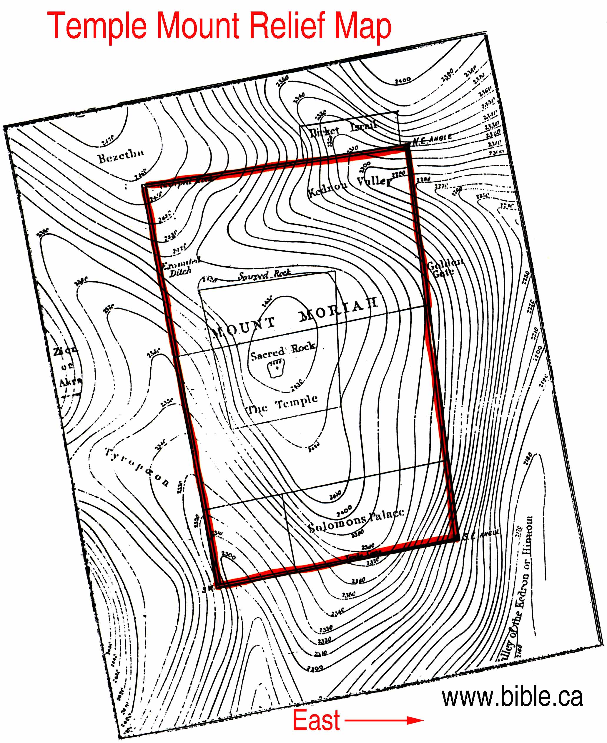
The ground is thus formed into two spurs, which run out from the higher ground on the north-west of the city, the western and highest of which is the Mount Zion of the Bible, and the "Upper "city" of Josephus; whilst the eastern is Mount Moriah, upon which the Temple formerly stood, and the Mosque of Omar, or Dome of the Rock, at present stands.
MOUNT ZION
The citadel occupies the narrow neck of ground between the valley of Hinnom and the Tyropean valley, and barred the only level approach to the ancient city (for that part of the city which lies to the north of the citadel is, comparatively speaking, a modern addition), and which, being surrounded by valleys on every other side, and being 110 feet higher than Mount Moriah, must have been a very strong commanding position for a small city.
There can, therefore, be no doubt but that this hill is Mount Zion, for it has been so called in all subsequent histories, and is so called at present.
MOUNT MORIAH
From the 21st chapter of the 1st Chronicles we learn that David bought the threshing floor of Ornan the Jebusite, and "built there an altar unto the Lord."
No one has ever questioned that the Temple formerly stood within the Haram-es-Sherif; and therefore there can be no doubt but that the hill on which the Haram stands has been properly named Mount Moriah.
Now, although on the sketches of the ground the contours and the levels indicate the hills and valleys which have been described, these features are defined with less of that sharpness and distinctness which they must have had in former times. We learn from history and from actual exploration underground that the Tyropean valley has been nearly filled up, and that there is a vast accumulation of ruins in most parts of the city.
Thus, for example, it has been found, by descending a well to the south of the central entrance of the Haram, that there is an accumulation of ruins and rubbish to the extension of 84 feet; and that originally there was a spring there, with steps down to it, cut in the solid rock.
Now, if we examine the photograph of the rocks and houses to the west of the valley, we see that the side of the valley was there nearly precipitous (see Photograph No. 31.a.), and that the ground southward was also very steep, if not also precipitous.
So again, if we refer to the photograph of the stairs, No. 37.b., cut in the solid rock in the English cemetery, we know that this was covered up with about 40 feet of rubbish; and there can be little doubt but the scarped rocks visible in the cemetery itself extend to a great depth below, and probably formed the southern boundary of the ancient city.
Again it was found that there was not less than 40 feet of rubbish in the branch of the valley of the Cheesemongers near the citadel; there is also a large accumulation in that small valley which has been described as joining the valley of the Kedron at St. Stephen's gate.
In fact, we know that it was part of the settled policy of the conquerors of the city to oblite-rate, as far as possible, those features on which the strength of the upper city and the Temple mainly depended. The natural accumulation of rubbish for the last 3,000 years has further contributed to obliterate to a great extent the natural features of the ground within the city.
PLAN OF THE CITY
Having described the ground upon which the city stands, we may now give a brief description of the city itself.
The form of the city may be described as that of an irregular rhomb or lozenge, the longest diagonal of which runs from NE to SW, and is 4,795 feet, or less than a mile long.
The northern side is 3,930 feet long, the eastern 2,754 feet, the southern 3,245 feet, and the western 2,086 feet long, as measured straight from point to point.
The total area of the city within the walls is 209.5 acres, or one-third of a square mile, but in addition to the large area of the Haram-es-Sherif, which is 35 acres, there are many open places about the city walls which are not built upon.
It is consequently only equal in extent to a very small English town, but the population is very dense, the houses being piled upon one another, even in many places across the streets, and in the year 1865 was estimated at about 16,000, but at Easter time the number of pilgrims and travellers increase the population to about 30,000.
The whole city occupies no larger a space than the block of the City of London included between Oxford Street and Piccadilly, and between Park Lane and Bond Street.
There are five gates to the city, the Damascus gate in the centre of the northern side, St. Stephen's gate on the east side, a little to the north of the Haram enclosure. In the south side there are two, the Water or Dung gate in the Tyropean valley, and the Zion gate on the hill of that name.
Jaffa gate is in the centre of the west side, and immediately under the walls of the northern front of the citadel.
The photographs, Nos. 32, 33, represent the Damascus gate, and portions of the wall to the west of it, with the scarped rocks upon which the wall is built. No. 34 represents the Zion gate.
The city is intersected from north to south by its principal street, which is three-fifths of a mile long, and runs from the Damascus gate to Zion gate. It is about the length of the street running from St. James's Palace along Pall Mall to St. Martin's Church. From this principal street, the others, with the exception of that from the Damascus gate to the Tyropean valley, generally run east and west, at right angles to it; amongst these is the Via Dolorosa along the north of the Haram, in which is the Roman archway, called Ecce Homo. See Phot. No. 27 b.
THE QUARTERS OF THE CITY
The city is divided into quarters, which are occupied by the different religious sects. The boundaries of these quarters are defined by the intersection of the principal street, and that which crosses it at right angles from the Jaffa gate to the gate of the Haram, called Bab as Silsile, or gate of the Chain.
The Christians occupy the western half of the city, the northern portion of which is called the Christian quarter, and contains the Church of the Holy Sepulchre; the southern portion is the Armenian quarter, having the Citadel at its northwest angle.
The Mahometan quarter occupies the north-east portion of the city, and includes the Haram-es-Sherif. The Jewish quarter is on the south, between the Armenian quarter and the Haram.
WATER SUPPLY
The city is at present supplied with water principally from the numerous cisterns under the houses in the city, in which the rain water is collected, but as even the water which, during the rains from December to March, runs through the filthy streets is also collected in some of these cisterns, the quality of the water may be well imagined, and can only be drunk with safety after it is filtered and freed from the numerous worms and insects which are bred in it. A supply is also obtained from Joab's Well, from whence it is brought in goat skins on donkeys, sold to the inhabitants; but this is also very impure.
Of the drainage of the city it is sufficient to say, that there is none in our acceptation of the word, for there are no drains of any kind from the city, and the accumulation of filth of every description in the streets is most disgraceful to the authorities.
ANCIENT SUPPLY
But when we come to examine the ancient systems for supplying the city with abundance of pure water, we are struck with admiration for we see the remains of works which, for boldness in design and skill in execution, rival even the most approved system of modern engineers, and which might, under a more enlightened government, be again brought into use.
From the three Pools of Solomon, as they are called, water was led by a conduit from the lower pool along the contour of the ground into the city, the distance being about 13 miles, and the fall 538 feet but the pools were supplied not only from the "sealed fountain" immediately above them, but from a conduit which has been traced for several miles along the Wady Urtas, but not to the source from which the water was obtained. (This has since been traced by Capt. Wilson in a fine fountain in the Wady Aroob, and the Pacha of Jerusalem has repaired the conduit from Solomon's Pools to Jerusalem, which is now supplied from Ain Etan and the "sealed fountain" above the upper pool).
Josephus tells us that " Pilate, the procurator of Judea, undertook to bring a current of water to Jerusalem, and did it with the sacred money, and derived the origin of the stream from the distance of 200 furlongs" (Antiquities of the Jews, Book XVIII, Chap. III. par. 2); and it is quite possible that this is the work referred to.
In constructing this conduit, tunnels were cut through a hill near Bethlehem, and through another hill on its way to the valley of Hinnom, crossing which, above the Lower Pool of Gihon, it was led round the southern end of Mount Zion, and entered the city at the altitude of 2,420 feet on the west side of the Tyropean valley.
The conduit was not traced beyond this; but by reference to the levels within the city, it is evident that it might have been carried as far up the Tyropean valley as the spot on which the Austrian Hospice now stands, the level on the front of which is 2,418 feet, but this is much above the original level of the ground. It might also have been led to any of the cisterns within the Haram enclosure, the height of the surface ground being only 2,418 feet at the northern gates. The Pool of Bethesda might also have been filled from it, the height of the bottom of which is 2344 feet.
The two beautiful fountains in the street El Wad, and that near the court-house, of which photographs are given (see Frontispiece and No. 28 a.), might also have been supplied with water brought in at the level of this conduit, these are supposed to be of the sixteenth century, (Moryson, who was at Jerusalem in 1596, says, when describing this part of the city, " Here I did see pleasant fountains of waters.")
But there is a second conduit, which is still more remarkable, and which we have distinguished by the name of the high-level conduit. This comes front the south, down the Wady Byar, in which it is probable a reservoir was formerly constructed; a tunnel through a hill led round the Upper Pool of Solomon at an elevation of 2,616 feet, and preserving its elevation by following the contour of the ground, till it crosses the ridge of the hill to the west of Bethlehem; it is carried by a syphon across a hollow which lies in its course, near Rachael's tomb, the lowest part of the syphon being over 100 feet below its mouths.
This syphon is made of blocks of stone with collar and socket joints, and covered with rough rubble in cement to strengthen and protect it, as shown in the sketch. The internal diameter of the syphon is 15 inches.
His Royal Highness Prince Arthur examined a stone syphon of a similar kind at Patara, in Lysia, at the south-west angle of Asia Minor, the internal diameter of which was nine inches.
This high level conduit then crosses the plain of Rephaim towards Jerusalem, and most probably passed round the Upper Pool of Gihon and entered the city through the citadel; the fall from above the Pools of Solomon to the Jaffa gate being 88 feet.
It will thus be seen that the water by these conduits was brought from different sources; and that by the high level one the upper city could be fully supplied with water, and that means were provided for running the water of the upper into the lower both at the Pools of Solomon and at the Pools of Gihon. This arrangement seems to prove that the city was supplied at one and the same time from two principal sources, as well as from the sealed fountain above the Pools of Solomon.
As regards the tradition that the city was supplied from springs within its walls, the geological and physical structure of the ground, taken in connexion with these great works to supply the city from distant sources, renders it extremely improbable that any spring of importance ever existed within the city walls. The valleys surrounding the city are dry water-courses, such as may be seen in the chalk districts of this country; and it is only during the heavy rains that the surface water is in part carried off by them. The spring in the Tyropean valley, with steps cut down to it, must necessarily have given only a very insignificant quantity of water; and the quality and quantity of water found at the Pool of Siloam, although described by Josephus as being sweet and in great plenty, is now very impure and insignificant in quantity...
HOLY SEPULCHRE
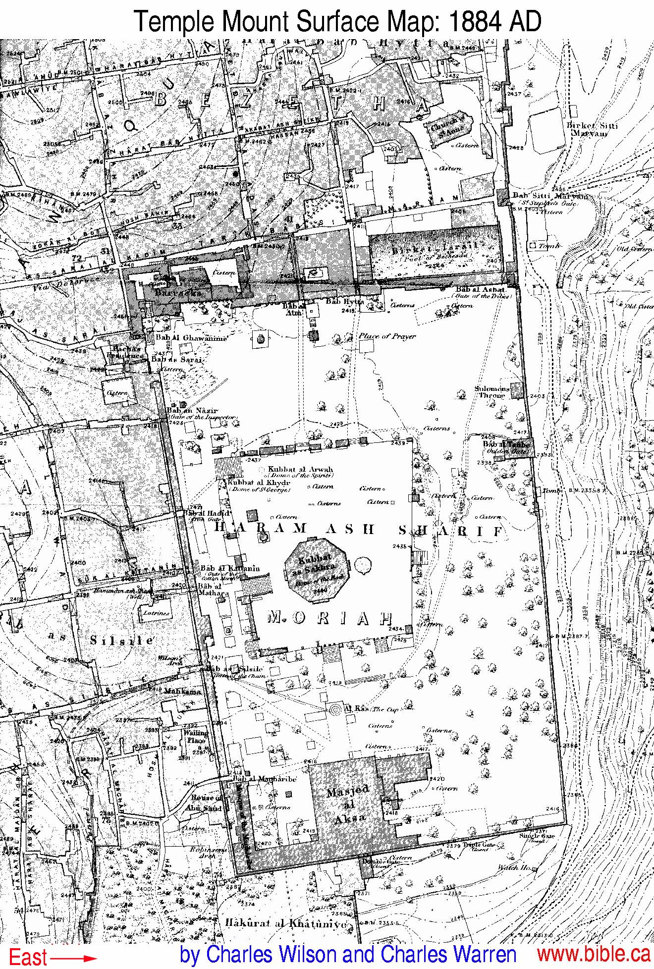
...The Haram-es-Sherif is a large quadrilateral enclosure of 35 acres, and nearly one mile in circuit,
The northern side being 1,042 feet long,
the eastern, 1,530 feet,
the southern 922 feet,
the western 1,601 feet long.
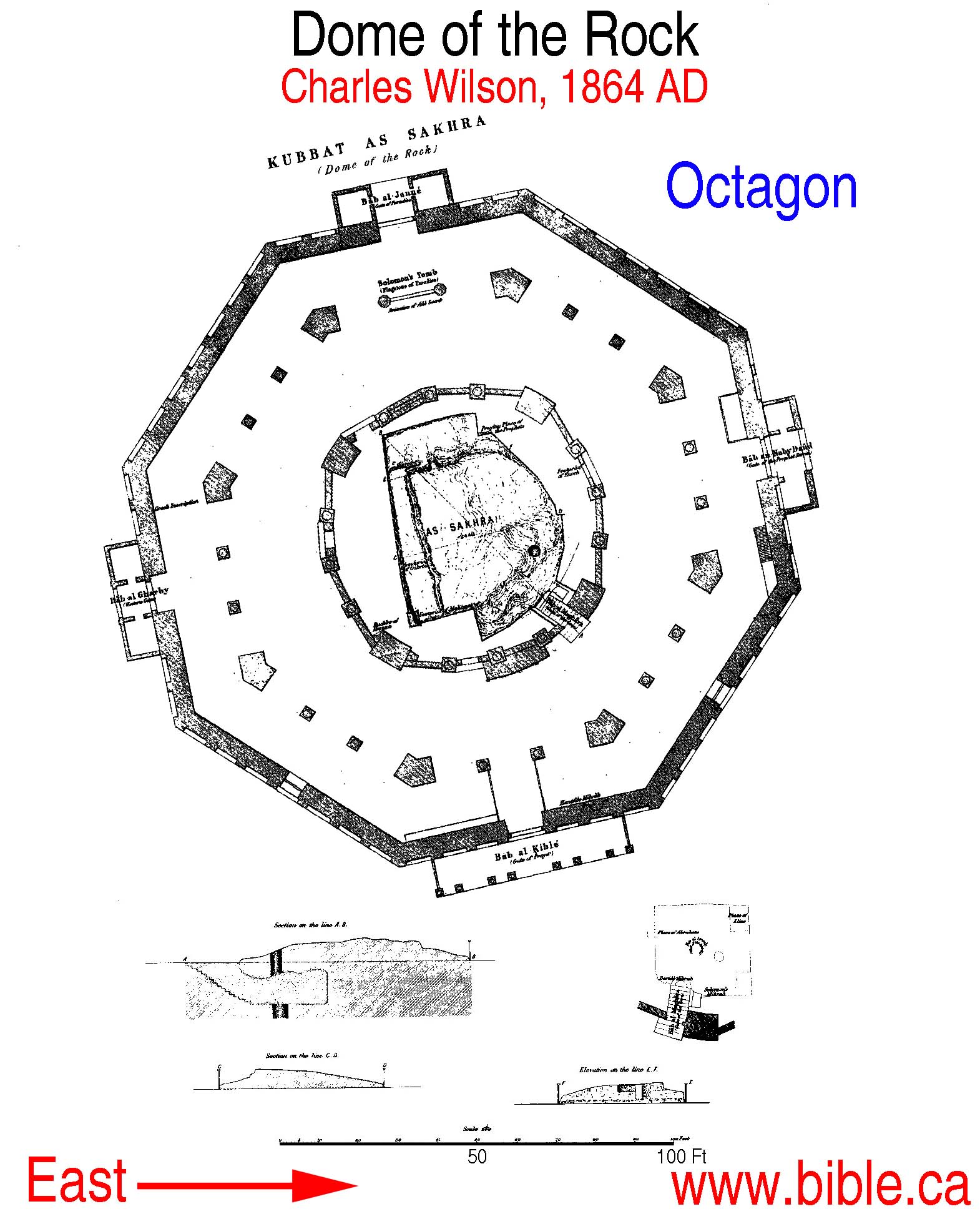
The Mosque of Omar, or Dome of the Rock, stands on a platform a little to the west of the centre of the enclosure. The Dome of the Chain, or Tribunal of the Prophet David, is as near as possible in the centre of the enclosure.
The Dome of the Rock is a magnificent building, erected over and around the Sakhra. The Sakhra is a portion of the natural rock, the summit of Mount Moriah; its highest point stands 4 feet 9.5 inches above the marble floor of the Mosque, and is 2,440 feet above the level of the sea.
Beneath the Sakhra there is a cave, which is entered by descending some steps on the south-east side. The cave itself is about 9 feet high in the highest part, and 22 feet 6 inches square; a hole has been cut through from the upper surface of the rock into the chamber beneath, and there is a corresponding hole immediately under it, which leads to a drain down to the valley of the Kedron. This hole is supposed to have been made for the purpose of carrying off the blood of the animals sacrificed on the rock when it was the altar of burnt offerings to the Temple.
The Mahometans venerate this rock as the spot from which, according to their belief, their prophet ascended to heaven.
The Dome of the Rock, as we see it at present, is a restoration by Soliman the Magnificent, iii the middle of the sixteenth century, of the building originally erected over the Sakhra by Abd-el- Melik-Ibn-Menvan in AD 688 to 691.
The Crusaders took Jerusalem in AD 1099, and called the Dome of the Rock the "Temple of the Lord," and the mosque El Aksa the "Palace of Solomon;" and it was here that King Baldwin founded the celebrated order of Knights Templars.
After the expulsion of the Christians these buildings were again converted to the purposes for which they were originally designed.
ENCLOSURE OF THE TEMPLE BY HEROD
As regards the question as to whether the present area of the Haram-es-Sherif corresponds with the area of the enclosure of the Temple, as it was built by Herod, we are informed by Josephus that in the time of Herod "the fortified places about the city were two, the one belonging to the city itself, the other belonging to the Temple; and those who could get them into their hands had the whole nation under their power, for without the command of them it was not possible to offer the sacrifices;" and again, "Herod had now the city fortified by the palace in which he lived, and by the Temple, which had a strong fortress by it called Antonia, and was rebuilt by himself." The similarity of the commanding positions selected for these two fortresses, the citadel and the tower of Antonia, and of the ground forming the two hills, is very striking.
The fortress rebuilt by Herod was that formerly built on the same spot and called Baris.
This fortress, Josephus goes on to say, "was erected on a great precipice," and " stood at the junction of the northern and western cloisters, that is, on the north-west angle of the enclosure of the Temple;" and that "it had passages down to both cloisters, through which the guard (for there always lay in the tower a Roman legion) went several ways among the cloisters with their arms on the Jewish festivals, in order to watch the people."
Josephus, in his description of the siege of the Temple by Pompey, BC 63, says that the Roman Commander found it impossible to attack it on any other quarter than the north, on account of the frightful ravines on every other side; and that even on this side he had to fill up "the fosse and "the whole of the ravine, which lay on the north quarter of the Temple;" and in the description of the siege of the Temple by Herod, BC 38, 37, he says, that Herod made the attacks in the same manner as did Pompey, that is, from the north side of it.
When he comes to the description of the siege by Titus, AD 70, the Temple with its enclosure, and the tower of Antonia at the north-west angle of the enclosure, having been entirely rebuilt by Herod, BC 17, Josephus says that the design of Titus was "to take the Temple at the tower of Antonia;" and that for this purpose he raised great banks; one of which was at the tower of Antonia, and the other at about 20 cubits from it; and that for the purpose of obtaining materials for filling up the immense fosse and ravine to the north of the Temple, he had to bring them from a great distance; and that the country all round for a distance of 19 or 12 miles was made perfectly bare in consequence.
After a protracted siege the tower was at length taken possession of by the Romans, and from it Titus directed the further operations of the siege against the inner enclosures of the Temple itself; during which "the Romans burnt down the northern cloister entirely, as far as the east cloister, "whose common angle joined to the valley that was called Kedron, and was built over it; on which account the depth was frightful."
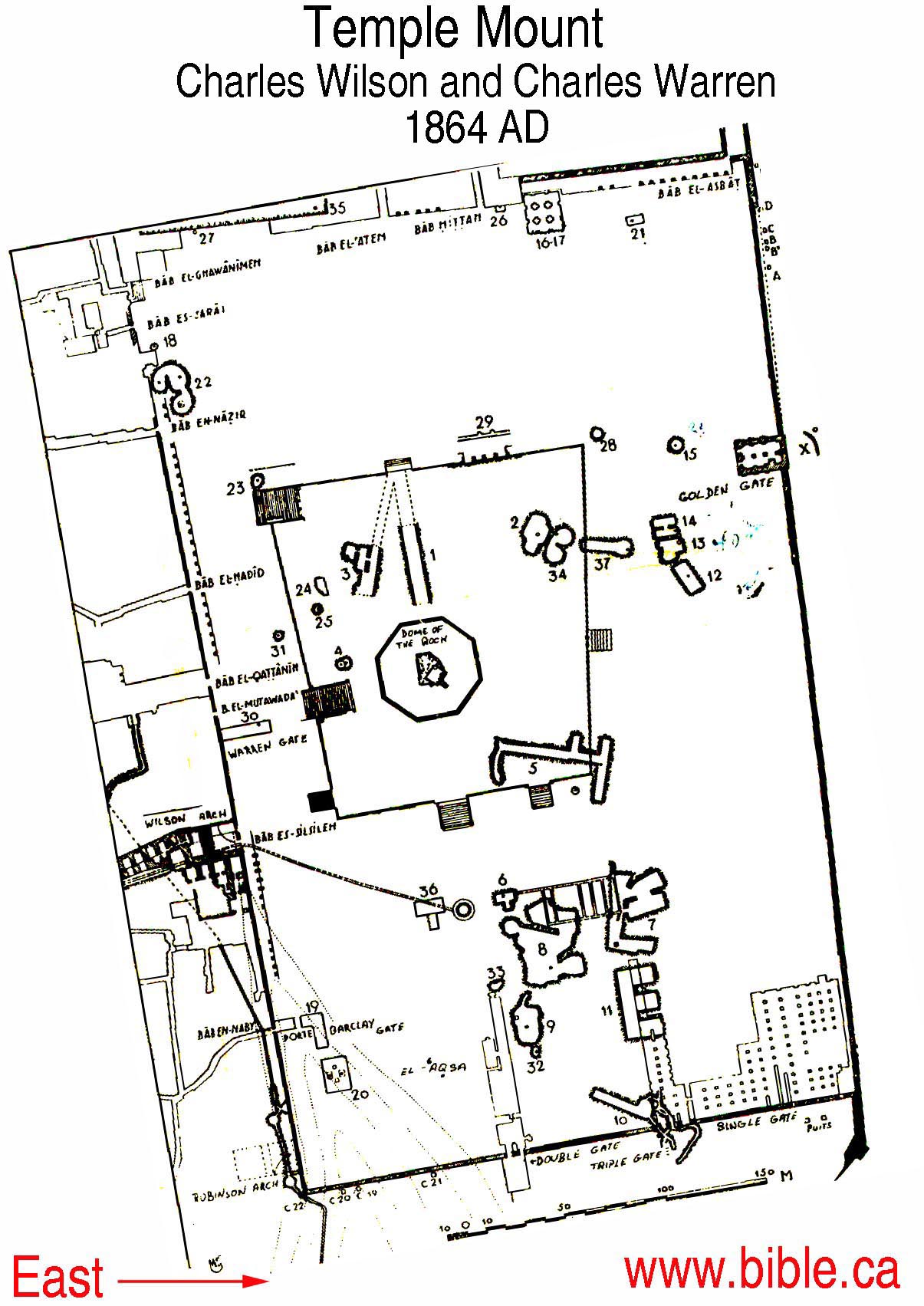
Now, on referring to the plans and photographs of the Haram enclosure, No. 7, we see that there is a high rock on its north-western angle, the precipice upon which the tower of Antonia formerly stood, and upon which the barracks for the Turkish guard now stands; we see also that this rock has been in part cut away to make the enclosure square, as Josephus tells us it was.
We see also that the northern side of the enclosure extends to the edge of the valley of Kedron, and that outside there is an immense fosse, now called the Pool of Bethesda, No. 16, and also the ravine which has been described as being on the northern quarter of the Temple.
It would seem, therefore, to be impossible to resist the conclusion, that the northern front of the Haram is identical in position with that of the northern front of the enclosure of the Temple, as it was built by Herod, for the description would apply to no other position for it.
In the description of the enclosure of the Temple, Josephus tells us that "both the largeness of the square edifice and its altitude were immense, and that the vastness of the stones in the front was plainly visible;" and that "the wall was of itself the most prodigious work that was ever heard of by man."
By means of the photographs and actual measurements we can judge how far this description is applicable to the lowest, and therefore oldest, courses of masonry, which can be traced at intervals nearly all round the enclosure of the Haram.
In examining the photographs, Nos. 17 and 18, of the north-east angle, we find that the lower courses of the masonry are composed of immense stones, one of which is no less than 23 feet 8 inches long and 4 feet deep; and that there is a wide "marginal draft," 5.25 inches wide to these stones, giving the masonry a very bold, and at the same time a very peculiar character, which should be specially noted.
The "batter," or slope of the wall, is obtained by setting back each course of stones 4 or 5 inches, which also gives a peculiar character to the masonry.
From the north-east angle we trace this peculiar masonry down to, and for 51 feet beyond, the Golden Gate; and again in great perfection for about 250 feet before arriving at the south-east angle, No. 11, where we see the same peculiar marginal draft to the stones and batter to the wall as at the north-east angle; one of the stones here is 39 feet 8 inches long. Turning the south-east angle, we trace the same peculiar masonry nearly all along the southern side of the enclosure to the south-west angle, Nos. 12, 13, where again this grand old masonry is seen in great perfection, one of the stones at this angle measuring no less than 38 feet 9 inches in length, 19 feet deep, and 4 feet thick.
Thirty-nine feet north of the corner we meet with the springing of a great arch, called Robinson's arch, No. 14. This arch was 50 feet wide, and must have had a span of about 45 feet.
Proceeding northward, we trace this old masonry at one of the ancient gates of the city, the whole of the lintel over which could not be measured, but the part exposed measured 20 feet 1 inch in length, and was 6 feet 10 inches in depth. Immediately north of this gate is the Wailing Place of the Jews, in which the old masonry is again seen in great perfection, Nos. 14, 15.
From this the old wall is traced to the pool or cistern " El Burak," under the entrance gate (Bab-as-Silsile) to the Haram, the northern portion of which is covered by a semicircular arch, having a span of 42 feet and a width of 43 feet. This arch was discovered by Captain Wilson; it abuts against the old wall, and, as in Robinson's arch, the springing stones form part of the old wall itself.
The western wall of the enclosure is perfectly straight throughout its length, but from Wilson's arch northwards the Haram wall can nowhere be seen below the level of the enclosure. There is an accumulation here of rubbish to the depth of 72 feet, on which the modern Moslem houses arc built too close together to admit of explorations under ground, and which, if it were possible, would not be permitted by the Turkish Effendis, the tombs of whose families are placed as close as possible to the sacred enclosure.
We see, however, that all round the enclosure, where it is possible to examine the wall, we have the same grand old masonry; and as there can be no doubt but that Robinson's arch is part of the bridge which Herod built across the Tyropean valley, and led to the royal cloister, which he also built along the south side of the enclosure of the Temple, it necessarily follows that the present Haram enclosure is identical with the enclosure of the Temple of Herod.
We are further confirmed in this view of the subject from the description which Josephus has given of the south side of the enclosure, " which reached in length from the east valley unto that on the west, for it was impossible it should reach any further;" and we see how this side extends, as described, to the very edge of the valley on each side, and this description would not apply to any other supposed position or extent of the south side.
So again, if we examine the substructures on this side, we see that in making the foundations some of the inner parts, as Josephus says, were included and joined together as part of the hill itself to the very top of it, when " he (Herod) wrought it all into one outward surface, and filled up the hollow places which were about the wall, and made it level on the external upper surface."
In the south-east angle we find that the present level surface of the ground is supported by a great number of arched vaults, and although the existing vaults may be of a much more recent date than those constructed by Herod. it is difficult to resist the conclusion that the supporting pillars are on the exact lines of the ancient supports, the distances between them corresponding so nearly with the dimensions given by Josephus, viz., 45 feet for the central walk, and 30 feet for the two others.
After a careful consideration of what has been written about the sites of the Holy Places, I feel convinced that the traditional sites are the true sites of Mount Zion and the Holy Sepulchre, and of Mount Moriah and the Temple.
Ordnance
Survey Office,
Southampton, 29th March 1866.
HENRY
JAMES,
Colonel Royal Engineers
III. HARAM-ES-SHERIF
Haram-es-Sherif is the name now commonly applied to the sacred enclosure of the Moslems at Jerusalem, which, besides containing the buildings of the Dome of the Rock and Aksa, has always been supposed to include within its area the site of the Jewish Temple. Mejr-ed-din, as quoted by Williams, gives Mesjid-el-Aksa as the correct name of the enclosure, but this is now exclusively applied to the mosque proper.
The masonry of the wall which encloses the Haram is of varied character, due to the numerous reconstructions which have taken place during the present era. The lowest courses, and therefore the oldest, are built of what have been generally called " beveled" stones, a term which has led to much confusion, the style being in reality almost identical with that of the granite work in the forts now building in England, cache stone having a "draft" from one-quarter to three-eighths of an inch deep, and two to five inches broad, chiseled round its margin, with the face left rough, finely picked, or even chiseled, according to the taste of the time or labour that could be spared upon it; of the rough work, some portions of the wall near the south-east angle show the best specimens; of the finer, the Wailing Place is a well-known and favourable example. The annexed sketch shows the detail from stones at the Wailing Place; from local indications the fine dressing appears to have been given to the faces after the stones were set. Above these stones, and often mixed with them, are those and during the first reconstruction, large blocks scarcely inferior in size to the older ones, but having plain chiseled faces without a marginal draft ; this gradually changes into another style, similar in workmanship, but with a very marked difference in the size of the stone, and above comes the later work, of the same date as the great rebuilding of the walls by Suleiman the Magnificent. At the south-west corner another species of masonry is found, which, from other remains of the same kind in the city, appears to be of the Saracenic period, prior to the Crusades; the stones are small, and have a deeply-chiseled draft round their margins, so as to leave the faces projecting roughly two or three inches. The mode of obtaining the necessary batter or slope to the wall has been in each style of building by setting the courses back from half an inch to an inch) as seen in sketch.
It is extremely difficult to tell what portion of the old masonry of the Haram wall is really "in situ;" it may be urged that the stones are so large that they could not easily have been over-thrown, and that wherever they are found in masses they must necessarily be in their original position, but a strong argument against this is the badness of the actual building, for it seems hardly conceivable that men who went to such great expense and labour in tooling the beds and sides of their stones should afterwards disfigure their work by leaving wide open joints, as is here usually the case; some of this defect is due to weathering, but the part thus destroyed can easily be seen, and at Hebron and Baalbek, where the masonry has been less disturbed than at Jerusalem, the joints are so close that it is difficult to insert a knife. Great want of judgment has been shown in the choice of material, and no care has been taken to place the stones on their quarry beds, which has made the progress of decay much more rapid than it would otherwise have been. To the north of Jerusalem, between the Tombs of the Judges and the village of Shafat, there is a very curious tomb, having in its vestibule a representation of the old mural masonry cut on the solid rock, and if this is a copy, as it probably is, of the style in use when the tomb was made, there is certainly nothing now "in situ" in the Haram wall, except perhaps the south-west corner and a portion of the wall under the Mahkama. A glance at the accompanying sketch will show the beautiful regularity of the work at the tomb, having, in elevation, the appearance of Flemish bond in brickwork, the marginal drafts of the blocks being chiseled and the faces finely picked. Though, however, much of the masonry now visible may not be " in situ," the present wall has probably been built on the foundations of the older one, and the same stones re-used without that regard to neatness of workmanship which would be shown in a time of great national prosperity.
The material used in the older portions of the wall is from the "missae" and "malaki" beds of stone, in the later Turkish additions from the "cakooli." The "missae," if well chosen, is extremely hard and good, and may be readily recognized in the wall by the sharpness of its angles, which are often as clean and perfect as when they left the mason's hands, even the marks of the toothed chisel being seen on many of the marginal drafts; this stone, however, varies in. different beds, and little care has been shown in selecting the best, many of the fine blocks being ruined by the rain or moisture which has found its way into the faults or veins which run through them. The "malaki" is good if it can be kept from the rain, and stone free from flaws is used; most of that in the wall has suffered severe]y from the weather. The "cakooli" is soft; and inferior as a building material.
A fuller description of the lower or oldest portion of the wall, as seen from. the outside, may now be given, commencing with the north-east angle, where, in the so-called Castle of Antonia, we find five perfect courses of large stones with marginal drafts, and above these at the northern end portions of six others; the draft is here 5.5 inches wide, and the faces of the stones are better worked than near the south-east angle; the courses vary from three to four feet in height, and some of the blocks are of great length, one being 23 feet 8 inches. The straight joint left between this mass of masonry and the city wall running north, with the sudden termination of the large stones, shows it to have been in existence long before the latter was built, and the appearance of the southern end, where the stones are properly bonded and the draft completed round the corner, would seem to indicate that the four lowest courses were "in situ," if it were not for the irregularity and coarseness of the jointing. Between this tower and the Golden gateway, one, two, three, and occasionally four courses of large stones are visible, the lowest of which projects beyond the others, and seems never to have had the dressing of its face completed. Several of the stones in this part of the wall are the remains of door jambs and lintels.
The piers of the Golden gateway are built of stones having plain chiseled faces; the northern one is not so well built as the southern, and stones taken from other buildings seem to have been made use of, if we may judge from one or two which have reveals or notches cut in them. The piers are flanked by buttresses of more modern date, which were built to sustain the mass of masonry placed above the gateway when it was turned into one of the flanking towers of the wall, and the entrance was probably closed at the same period; to gain the necessary slope or batter the buttresses were pitched forward four inches, and to take away the unsightliness of the projection the inner edges were chamfered, as seen in sketch annexed.
From the Golden gateway to the "so-called" postern, a distance of 51 feet, there are three courses of large stones, with marginal drafts three to six inches wide, and extremely rough faces, projecting in many cases as much as nine inches. Over the doorway there is a sort of lintel, but there are no regular jambs, and the whole has more the appearance of a hole broken through the masonry and afterwards roughly filled up, than that of a postern in a city wall, still it probably marks the site of Mejr-ed-din's gate of Burak. To the left or south of this there is a curious stone, hollowed into the shape of a basin, which on three sides is perforated by a round hole, and attached to the one at the back is a portion of an earthenware pipe, which was probably at one time in connexion with the water system of the Haram, and supplied a fountain at this place.
Southwards from the postern the stones have all plain chiseled faces, and portions of several broken marble columns have been built transversely into the wall, with their ends left projecting several inches, but shortly after passing "Mahomet's pillar" the marginal draft is again met with, and the ground falling rapidly towards the south-east angle, exposes 14 courses at that point. Shortly before reaching the offset which mark the position of the corner tower, two stones, forming the springing of an arch, and extending over a length of 18 feet, are seen, and immediately above them there has been at some period a window to admit light to the vaults within, which is now closed with modern masonry, leaving a small chamber in the thickness of the wall. The annexed sketch shows the arrangement of the stones, which do not appear to be "in situ," and have nothing in their appearance to justify the belief that they formed part of the arch of a bridge over the Kedron valley; it seems more probable that they came from the ruins of the tower close by, part of the original vaulting of which, made of large stones, may still be seen in the "Cradle of Jesus."
The stones at the south-east angle form a species of ashlar facing to a mass of coarse rubble work (seen in the vaults), and from this and the fact that the offset at the north end is sometimes formed by notching out the stone, the draft being continued on both tower and wall, it seems probable that they are in their original position. The courses vary in height from 3 feet 6 inches to 4 feet 4 inches, and are set back from half to three-quarters of an inch as they rise; the upper portion of the wall is sadly out of repair, and looks as if the least touch would bring it down; from its summit the wavy, irregular course of the eastern boundary of the Haram can easily be distinguished by the eye.
Turning the corner and proceeding along the southern wall, the 14 courses of large stones break down rapidly, and the ground rises so as to allow only one course to be seen at the "single gateway," a closed entrance to the vaults, which has a pointed arch.
Between the "single" and "triple gateways" there is one course of stones with the marginal draft, with a few scattered blocks above. The " triple gateway" is closed with small masonry, its arches are semicircular, with a span of 13 feet, and the stones in both piers and arches have plain chiseled faces. In front of the gateway are some large fiat slabs of stone, which appear to have formed part of a flight of steps leading up to it; an excavation was made here, and three passages discovered by Monsr. De Saulcy explored, a description of which will be given in another place. To the west of the gateway there are two courses of stones with the draft, and one of these can be traced to the " double gateway," where it abruptly terminates; this course is of some height, 5 feet 5 inches being seen above ground, and the blocks are finely finished with plain picked faces, and 3.25 inch draft chiseled round the margins; one of these stones, which forms part of the left jamb of the western entrance of the "triple gateway," has a moulding worked on it, which seems to have been intended as a sort of architrave, and to have been worked at the time the gateway was built, certainly after the stone was set; on its face the characters shown in Sketch 4, Plate XI can be traced.
At the "double gateway," a portion only (5 feet 8 inches) of which is seen, further progress is stopped by a wall running southwards; but, entering the city, part of the ornamental arch over the western door is found in a vault of the Khatuniyeh, and thence the southern boundary of the Haram may be traced to the south-west angle. The construction of the "double gateway" will be better examined from the interior; but here it may be noticed that adjoining the relieving arch over the lintel of the eastern door is the Antonine inscription built into the wall upside down, most of the letters still retain their sharpness, and with the aid of a magnifying glass may be read from the photograph; they are shown in Sketch 5, Plate XI.
In the portion of Haram wall seen within the vaults of the Khatuniyeh plain chiseled stones and those with a marginal draft are mixed up together, but from thence to 50 feet east of the corner the former only are found; at this point, by forcing a way through the thick growth of cactus, the junction of the two styles of masonry may be seen, and as this takes place near the ground line, it shows how complete must have been the destruction of this part of the retaining wall at the period of reconstruction. The south-west angle, and 50 feet on either side of it, is the finest and best preserved piece of old masonry in the wall, and the stones have more the appearance of being "in situ" here than at other places; one of the blocks is 38 feet 9 inches long, nearly 4 feet thick, and 10 feet deep, and there are others of little less size; the bonding of the stones has been carefully attended to, and the workmanship is admirable; unfortunately the accumulation of rubbish and cactus against the sides of the wall prevent its being seen to such advantage as the south-east angle, which) however, is greatly its inferior in construction and finish. The southern boundary of the Haram is a straight line, the south-west corner a right angle, and the south-east corner an angle of 92 degrees 50 minutes; some trouble was experienced in getting the exact line of the southern wall, on account of the buildings which are clustered against it beneath the Mesjid-el-Aksa.
Thirty-nine feet north of the corner is the springing of an old arch, first brought to notice by Dr. Robinson, and now known by his name; portions of the three lower courses still remain, and from the appearance and position of the stones there can be no doubt about their having formed part of the original wall; the breadth of the arch is exactly 50 feet, and its span must have been about 45 feet, but from the upper stones having slightly slipped, and their surface being a good deal weather-worn, it was not possible to determine the exact curve; indeed, in several of the stones the line of the curve is no longer to be distinguished, as they have been taken from the "malaki" bed, which is soft and easily acted upon by. the weather. An excavation was carried to a depth of 37 feet, in search of one of the piers, without much result, except to impress still more on the mind the magnificent effect which must have been produced by a solid mass of masonry rising sharply from the valley to a height of probably not less than 80 or 90 feet, and crowned by the cloisters of the Temple. The line of springing of the arch is on a level or nearly so with the present surface of the ground, and an offset of 1 foot 3 inches, forming the top of the eastern pier or buttress, can just be seen.
From the arch to Abu Seud's house, and in his house as far as could be seen, there is a mixture of plain chiseled stones and those with a marginal draft, but just beyond this, in a small yard to the south of the Wailing Place, the older masonry is again found in the shape of an enormous lintel which S covers a doorway, now closed, leading into the small mosque dedicated to El Burak, the mysterious charger of Mahomet. The masonry is here of good, well-chosen material, and apparently "in situ;" the whole of the lintel could not be seen, its measured parts were 20 feet 1 inch in length by '6 feet 10 inches in height.
At Abu Seud's house is the Bab-al-Magharibe, or Gate of the Western Africans, so called from its proximity to the mosque of the same name; the approach to it is by a steep ascent from the valley, and it enters the Haram on a level with the area; there is nothing of great antiquity in its character.
Immediately north of the lintel is the Wailing Place, which has always been considered as part of the original sustaining wall of the Temple area, but the carelessness of the building, and the frequent occurrence of coarse open joints makes it doubtful whether the stones really are "in situ." The chiseled draft is here from 2 to 4 inches broad, and from one-quarter to three-eighths of an inch deep, and the faces are all finely worked. Many of the stones are a good deal worn by the weather, the decay being hastened by their not being placed on their quarry bed, or by their softness; indeed the material used is of very different quality, some being of the best "missae," as the whole of the second course from the bottom; which is admirably finished and in a good state of preservation, but above and below this, besides a few blocks of "malaki," a great deal of the upper " missae" has been used; this stratum, which may be almost called "cakooli," contains. a number of small nodules, which become loosened by moisture, and commence the work of destruction. The photograph, "Detail of Masonry at Wailing Place," shows the different kinds of stone used, and a few of the blocks set on edge. Several holes cut in the surface of the wall were rather puzzling, till their use was discovered, whilst exploring the vaults under the Mahkama, where they receive the groin point of the arches, so that a series of similar vaults must at one time have covered a great portion of the Walling Place wall.
Entering a small garden at the north end of the Wailing Place, a continuation of the same style of masonry is seen, and can be traced at intervals in the vaults under the Mahkama till the edge of the pool or cistern of " El Burak" is reached.
From this garden the face of the Mahkama, or court house, also built of stones with marginal drafts, can be examined; it is evidently constructed from old material, and at a much later date than the Haram wall, yet some of it has more the appearance of being " in situ" than many of the other remains in the city. The double series of vaults which support the court house seem of different ages, from the mixture of segmental and pointed arches; in those next the Haram, the skewbacks of the arches, and where requisite, the seat of the groin, has been cut out of the wall itself.
Descending into the pool of "El Burak," we find a fine portion of the Haram wall exposed, for a length of 36 feet, and then reach the springing of a large arch covering the pool. This arch is semi-circular, has a width of 43 feet and a span of 42 feet, abutting, westwards, on a solid mass of masonry' of the same style as the Haram wall There are 23 courses in the arch of equal thickness, which gives an almost painful appearance of regularity; and the stones, as far as could be judged from the bottom, ranged from 7 to 13 feet in length, not equal in size to those near the south-west angle, but from their perfect state of preservation forming the most remarkable remain in Jerusalem. Here, as at the south-west angle, the stones at the springing and for two courses above form part of the Haram wall, and whatever date is given to the masonry of the Wailing Place must be ascribed to this, whether it be the Herodian period or that of the first reconstruction after the taking of the city by Titus; if of the former, its perfect preservation may be easily understood, by its forming the best and readiest means of communication for troops passing from one hill to the other, and, as such, of the greatest importance to the Roman garrison.
Immediately north of this arch is another, which covers the remainder of the pool; it is of a perfectly different character, being made of rubble work of small stones, and not having such a large span; it appears also to be slightly pointed, but this cannot be very well seen from the bottom of the pool. At this point also there is an offset of five feet forming the abutment of the later arch, and built of rubble, which conceals the true line of the Haram wall. The north end of the pool is closed, and there is a flight of steps leading up to a door in it filled with loose masonry; an attempt was made to break through this and get down to the Haram wall 6n the other side, but unfortunately without success. Within the pool the joints of the large stones are covered with cement, and the sides of the later masonry at the south end are completely coated, but it is of bad quality, and beginning to peel off. The floor is formed of two thick layers of good cement eighteen inches apart, the space between being filled with rubbish, and the lower layer resting on a bed of small rubbish levelled to receive it. Through one of the arch stones a hole has been broken to draw water, but the pool seems to have been dry for some years. This is probably "the bridge" mentioned in the Norman Chronicle as quoted by Williams, at which time there appears to have been a free passage beneath to the "Dung Gate."
The principal entrance to the Haram area passes over the arch and enters on a level with the ground within through a double gateway; the one on the right is called the Bab-as-Silsile (Gate of the Chain), and the one on the left the Bab-as-Salam (Gate of Peace); at the bottom of the left jamb of the latter there is a massive stone with marginal draft, the north end of which corresponds with the end of the arch over the pool below. The decoration of the exterior face of the gateway is very handsome, and some of the twisted columns have been used in its construction.
From this point to the north-west angle the Haram wall can nowhere be seen below the present level of the area, attempts were made to get at it underground through every opening that could be found, but they were all unsuccessful; there is, however, one place which was not noticed till the winter rains had set in and stopped exploration, where something might be discovered; viz., a large cistern, near the Bab-an-Nazir, in the court yard round which the houses of poor Moslem pilgrims are ranged. North of the. Bab-as-Salam the rubbish along the western wall rises nearly to the level of the Haram area, and close to the Bab-al-Kattaanin has a depth of 72 feet; on this, and closely clinging to the western cloisters of the enclosure, are the modern Moslem houses, built too closely together to allow of exploration or excavation, if this were not already prevented by the numerous tombs of Turkish effendis placed as near as possible to the sacred enclosure, and reverenced by the present generation as of equal if not greater sanctity than the area itself.
There are six gates on the western side north of the Bab-as-Salam, known as the Bab-al-Matbara (Gate of the Bath), the Bab-al-Kattanin (Gate of the Cotton Sellers), the Bab-al-Hadid (Iron Gate), the Bab-an -Nazir or Nadhir (Gate of the Inspector), also known amongst Moslems as the Bab Ali-ad-din-al-Bosri, the Bab-as-Sarai (Gate of the Seraglio), and the Bab-al-Ghawanime, or Ghawrine, called also the Bab-al-Dawidar (Gate of the Secretary). The first of these is a small gate formerly leading to the Hammam-es-Shefa but now to the latrines attached to the Haram; the second is a handsome Saracenic doorway opening into an arcade, along the sides of which are ranged a series of vaulted chambers, once the Cotton Bazaar, now the receptacle of all the filth of the neighbourhood which is carelessly thrown in and walled lip when a chamber becomes full to overflowing. In the court yard of an effendi's house between the Bab-al-Hadid and Bab-an-Nazir, a portion of the exterior face of the Haram wall can be seen; its direction is in the exact prolongation of the hue of the Wailing Place, and the wall is composed of large blocks (with plain chiseled faces), backed with coarse rubble, one or two of the stones have the marginal draft, but the style of the work is that of the middle portion of the Wailing Place wall, and it is apparently of the same date. Great hopes were entertained of finding a lower portion of the wall in a cistern at this place, but on descending, the cistern turned out to be a small modern one built in the rubbish and not reaching as far as the wall; the effendi said that in sinking for the foundations of his house, he went down between 30 and 40 feet, and then finding no bottom built on the rubbish, and so great was his fear of it falling down from any disturbance of the ground in the neighbourhood, that not even the offer of a large bakhshish could induce him to allow a small excavation in front of the Haram wall so as to determine the character of the lower masonry. The Bab-as-Sarai leads to the official residence of the Pacha of Jerusalem, and is the gate by which Frank visitors generally enter the Mosque grounds. The Bab-al-Ghawanime is near the north-west angle, and is partly formed by cutting through the natural rock which here rises to the surface. The boundary of the Haram at the north-west angle is formed by houses built on the rock, which has been scarped on the side facing the area.
Turning the corner and proceeding along the northern side, the Barracks form the boundary for some distance; they are built on the rock, somewhat in the manner shown in the annexed sketch, the main building, which is entered by a flight of steps, being above the natural level of the ground; the escarpment on the south side is in places 23 feet high, and can be seen from the interior of the Haram , that on the north side is found in a chamber entered from the Tarik Bab Sitti Maryam (Via Dolorosa), by a door near the Barrack steps; the scarped face is 10 feet in from the street, and rises to a height of 8 feet, how far it continues below the made-up floor of the vault cannot he seen without excavation. Between this and the Birket Israel (Pool of Bethesda) the ground is so covered with buildings standing on a level with the Haram area, that neither rock nor wall can be traced, but in the pool the northern retaining wall is exposed to some depth below the Haram level; it is quite different in character from any other portion of the wall, and its construction is that ordinarily adopted in the pools round Jerusalem ; viz., large stones set widely apart, the joints being packed with small angular stones, to give the cement a better hold. In places large fragments of cement still adhere to the wall, but the pool is useless as a reservoir; it now receives the drainage of the neighbourhood, and the bottom is covered by a large accumulation of rubbish which conceals the original depth and makes exploration neither easy nor pleasant. At the west end there are two parallel passages covered with slightly pointed arches and of considerable size but now nearly choked up with filth, the drainage and refuse from the houses above being discharged into them by holes broken through the crowns of the arches ; near the pool there is a communication between the two passages by a low arched opening, but the most curious feature is that both passages are cemented as if they had been at one time used as water channels or additional reservoirs, the southern one, which runs along the Haram wall, was traced for 100 feet when the rubbish rose to the crown of the arch and prevented further progress; the cement and rubbish unfortunately concealed the character of the wall. The Birket Israel lies at the end of the shallow valley, which running down from the north-west passes between the Church of St. Anne and Al-Mamuniye, but it is difficult to say what was the original character of the ground, and what portion of the pool is cut out of the rock which is visible neither in the pool itself nor in the Haram behind it. The eastern end is closed by a dam formed, of the roadway leading into the Haram, and the city wall, but here again there is nothing to indicate the date or mode of construction, and without excavation no one can be certain whether the dam was built wholly or only in part at the time of the reconstruction of the walls, or whether it is wholly artificial closing up the end of the valley mentioned above, or partly rock and partly masonry. The annexed section through the pool and wall shows the present nature of the ground which deserves a more perfect examination. There are three entrances to the Haram on the north side, the Bab-al-'Atm. (Gate of Obscurity), the Bab Hytta (Gate of Pardon), which, according to Mejir-ed-din, derives its name from. the command given by God to the Israelites to say "pardon" as they entered it; and the Bab-al-Asbat (Gate of the Tribes [of Israel]), which is close to the north-east angle, and so-called Castle of Antonia; the stones in the north face of the castle have the marginal draft, and some of them appear to be "in situ," but the greater portion is a reconstruction most probably of the same date as the towers at the Damascus Gate; it is, however, much older than the wall running northwards which joins on to it with a straight joint.
The area of the Haram is a curious mixture of rock, made ground, and rubbish; in the north-west angle the rock forms the surface over a considerable extent of ground, and at the Bab-al-Ghawanime and under the Barracks there is an escarpment which rises in one place to a height of 23 feet; a portion of the passage leading out from the Bab-al-Ghawanime is cut out of the rock, and from this point the bare rock is seen sloping gradually down to the north-west corner of the platform, on which the Kubbat-as-Sakhra stands, where it again rises to nearly the height of the platform pavement. The ground has been lowered by cutting down perpendicularly at the north-west angle, and then removing the overlying strata as far as the platform, so that the surface of the rock, where seen, is at its natural slope or dip. Some very curious cuttings in the rock, which had the appearance of small water channels, for supplying a fountain, were noticed here but their arrangement and object could not be clearly traced. The strata that have been removed are the upper thin beds of "missae" and are exposed in section under the Barracks; they have a dip of 100 towards the east in the direction of the north wall, and of 150 towards the south in the direction of the west wail. In the north-east corner and between the Birket Israel and Golden Gate, there has been an immense amount of filling in to bring this portion up to the general level of the area, and it appears to have been done at a period long after the erection of the Golden Gate, the north side of which is nearly hidden by an accumulation of rubbish rising 26 feet above the sill of the western doorway. Immediately in front (west) of the Golden Gate there is a deep hollow, the descent to the entrance being over a sloping heap of rubbish, which, on excavation, would probably be found to cover a flight of steps leading up to the higher level; the southern side is not so completely covered as the northern, but even here the rubbish is 9 feet above the western door sill, and soon rises to the general level. A little to the south-west of the Golden Gate the rock is again found on the surface, having a dip of 100 due cast, and here only one layer of "missae" covers the "malaki," in which the cisterns are excavated ; nearly opposite this a portion of rock "missae" is seen in the wall of the platform. The south-east corner of the area is supported by an extensive system of vaulting, a detailed account of which will be given in another place. Over the space covered by the Masjed-al-Aksa and between it and the platform there is much less rubbish than has generally been supposed; the irregularity of the ground seems to have been levelled by building up the southern part with massive masonry and filling in the inequalities; at one point only, near the south-east corner of the platform, the natural rock is seen, rising about 9 inches above the ground, and having its surface chiseled so as to be horizontal, and near this there are a number of large flat stones, probably the remains of some ancient pavement. Along the whole western side of the area nothing can be seen sufficient to decide the original character of the ground; the Mosque "Al-Burak" near the Magharibe Gate, lies at a low level, but there seems no reason to suppose that there are any more vaults in connexion with it, spite of the Moslem tradition, which is here probably as groundless as it was proved to be in other places. In the south-west corner are two or three cisterns, which, as far as could be judged from the surface, appeared to be small and cut in the rock; if so, it would go far to prove the non-existence of a system of vaults similar to that at the south-east corner. There is nothing ancient in the appearance of the masonry of the platform, and the covering arches of the vaults on the west side and at the south-west corner are pointed; the chambers were so covered with plaster that no rock could be seen, they appeared to have been built to overcome the irregularity of the surface. At the north-west corner the rock rises nearly to the level of the platform, and wherever it can be seen in cisterns it is not far below the surface. The principal interest of the platform centres in the rock covered by the Mosque, which gives it an air of mystery and a prominence which, were the ground restored to its original shape, it would not possess; in forming the platform, there is no doubt that the rock was cut away in many places, and every possible means taken to give a complete and conspicuous isolation to the central point.
The "Kubbat-as-Sakhra" (Dome of the Rock), has been so frequently repaired and covered by various decorations, that it is difficult to say what belongs to the original building, however, westerly gales outside and Turkish carelessness within are rapidly reducing the Mosque to its original state; no attempt has been made of late years to carry out any repairs, and each succeeding winter sees the fall of larger portions of marble, fayence, and mosaic work, which are carefully collected and locked up till Allah shall send money to put them in their place again, or what is more probable till they disappear through bolts and locks by the mysterious agency of western "bakhshish." The rock is covered by a very elegantly shaped dome, supported on four piers, standing in the circumference of a circle of 75 feet diameter; between each of the piers are three columns from the capitals of which spring slightly elliptical arches which assist in carrying the tambour of the dome. This circle is surrounded by an octagonal screen containing eight piers and sixteen columns which carry an entablature above which are discharging arches slightly elliptical in shape. There is a peculiar feature in the entablature of the screen, that over the intercolumnar spaces the architrave is entirely omitted, and over the columns is represented by a square block cased with marble. A slab from one of the blocks had fallen, but on getting up to it nothing could be seen except the mortar backing against which the slab had rested, and any disturbance of this the Mosque attendants would not allow. The columns, averaging 5 feet 11 inches in circumference for the screen, and 7 feet 10 inches for the inner circle, are of various coloured marbles, and serpentine; they may have been taken from the remains of former buildings, but this can hardly be the case with the capitals, which are all identical in character and very similar to those in the basilica at Bethlehem, the details of capital and entablature are well given by De Vogue, in "Le Temple de Jerusalem," but after close examination no trace could be found of the cross shown in his engraving, many of the monograms or bosses are quite perfect, and have nothing of the cross about them, and in those destroyed the obliteration is so complete that it requires a very vivid imagination to make anything out of them.
Outside the screen is the main building, also octagonal, composed of the best "malaki" stone, finely chiseled, with close beds and joints, and-having on each side seven recessed spices or bays with plain semicircular heads. There are four entrances to the Mosque, the Bab-al-Tanne (Gate of Paradise), the Bab-al-Gharby (Western Gate), the Bab al-Kible (Gate of the Kible, that is "the gate on the side towards which they turn when praying," the Mecca side), and the Bab-an-Neby-Daud (Gate of the Prophet David); each appears formerly to have had an open porch of columns which with the exception of the one at the Bab-al-Kible have been closed in and cased with marble, leaving just room enough to enter by the doors, the side portions being turned into rooms for the attendants of the Mosque.
As far as can be judged, the oldest portion of the Mosque consists of the main building, screen, inner circle, and discharging arches, in fact, everything below the tambour of the dome stripped of its marble casing, ornament and roof, and this from the regularity of its construction, and the perfect agreement of its details, must have formed part of the original building.
The exterior of the Mosque is richly decorated with marble and fayence. The casing of various colored marble reaches from the ground to nearly the foot of the windows some little of it may be original, but the greater portion is a patchwork, in which old material has been used up, not, however, without some attention being paid to the design which is generally chaste and simple. The slabs are fastened to the stone by metal cramps, run in with lead, a good even bed of mortar having been prepared to receive them as shown in annexed plan and section. At the foot of the casing on the eastern side of the Mosque and built without any regularity of design are some curiously sculptured marble slabs evidently taken from some other building, as they have been cut down to fit the height of the base or plinth of the Dome of the Rock, one of these slabs was found forming part of the decoration of the Mihrab of John and Zechariah, in Al-Aksa, and another, the most interesting, with a Greek inscription partly cut off; built into the lower part of the casing within the Dome of the Rock and close to the Bab-al-Gharby. The inscription is given below, the latter portion of it seems to be "soterias Marias" in the face of the slab is a simple wreath, similar to the one on Sketch 4, Plate XIII, but without the intersecting squares in the centre. It seems very probable that all these slabs were taken from some Byzantine Church, and that the inscriptions were cut off when the material was re-appropriated; nothing like them was found in any other part of the city. Above the marble casing the original appearance of the Mosque has been altered by building new windows with pointed heads into the old ones, and so badly has this been done, without bond or tie of any kind, that some have completely fallen out, and all those on the western sides are rapidly approaching the same fate, leaving the semicircular arches behind plainly exposed to view. The whole of this portion as well as the outside of the tambour was covered with fayence, the eastern sides are perfect, and afford a good specimen of this style of decoration, but in consequence of the prevailing westerly winds and rain the sides facing that quarter are sadly out of repair. Three periods of workmanship can be traced, of which the first and oldest is far superior to the others both in elegance of design and quality of manufacture; the second is also very good, and specimens of it may be seen in two or three places in the city, where, in the Armenian church of St. James, it shows to better advantage than when beside the finer work on the Mosque; the third period is that of the later repairs which have been made in bad taste and with worse material. Each piece of fayence is 9.5 inches square, and was bedded firmly in strong mortar, a thick coating of which was spread over the whole exterior surface of the building. The interior face of the external wall is covered with a marble casing in which the use of old material is perhaps more apparent than in the work outside; the piers of the screen and inner circle are ornamented in the same way, and the soffits of the discharging arches under the dome are covered with alternate slabs of black and white marble. The capitals are gilded and the entablature painted with bright colors to bring out the salient points in the architecture; the bottom of the enablature is covered with a beautiful representation in bronze of vines with clusters of grapes. The pavement of the mosque between the external wall and screen is a confused mass of old material, amongst which there are many portions of sculptured slabs like those seen outside, one of which, a little to the north of the western gate is nearly perfect; between the screen and inner circle the paving has been better cared for, and round the rock itself the workmanship leaves nothing to be wished for.
The space between the external wall and inner circle is covered by a flat roof with a paneled wooden ceiling, very well finished, and similar to, though in a much better state of preservation than, the ceilings in some of the old mosques at Cairo. The whole internal surface of the dome and tambour is covered with arabesques in mosaic, which, though in some places peeling off; in others retain much of the original freshness of coloring. The discharging arches of the screen are covered with mosaic of an older date, with arabesque patterns and a Cufic inscription, which runs round the Mosque. The windows of the Mosque are remarkable for the beauty of their tracery, no less than for the brilliancy of the coloring, and the admirable way in which the different colors are blended, producing perfect harmony in the whole; one window near the western door is of especial beauty, but to be seen to advantage they should have the full blaze of a Syrian sun streaming through them, which unfortunately cannot be obtained on eight sides at once. The light is admitted through three mediums; first, there is on the outside, as seen in Photog. b, page 3, a thick coating of plaster or mortar, covered with fayence of an open net work pattern, which allows the light to pass to a second window of stone with white glass, and through this to reach the inner window which gives the design and coloring.
The rock stands 4 feet 9.5 inches above the marble pavement at its highest point, and 1 foot at its lowest; it is one of the "missae" strata, and has a dip of 12 degrees in a direction 85 degrees east of north. The surface of the rock bears the marks of hard treatment and rough chiseling; on the western side it is cut down in three steps, and on the northern side in an irregular shape, the object of which could not be discovered. Near and a little to the east of the door leading to the chamber below are a number of small rectangular holes cut in the rock, as if to receive the foot of a railing or screen, and at the same place is a circular opening, communicating with the cave, which may either have been the mouth of a cistern, or the ventilator of a tomb, for similar openings were found in the vestibules of most of the large tombs round Jerusalem, either for light and ventilation or to facilitate the excavation. The entrance to the cave is by a flight of steps on the south-east, passing under a doorway with a pointed arch, which looks like an addition of the Crusaders; the chamber is not very large, with an average height of six feet; its sides are so covered with plaster and whitewash that it is impossible to see any chisel marks, but the surface appears to be rough and irregular; on tapping the sides a hollow sound is produced, which the Moslems bring forward as a proof of their legend that the rock is suspended in the air, but after careful examination and trying places where no hollow could exist, it was found to arise from defective plastering, the plaster having become separated from the rock in much the same way as two coats do in careless and bad plasterers' work in England, where the defect is discovered by the wall producing the same sort of hollow sound. There may be a small opening in the side, but certainly no large one, unless it is blocked up with masonry. The floor of the cave is paved with marble, and produces a hollow sound when stamped upon, not merely over the mouth of the supposed well, but over nearly the whole surface.
The Mosque contains several objects held in great reverence by the Moslems; entering by the northern gate (Bab-al-Tanne), we find under our feet the Kabr Suleiman (Sepulchre of Solomon), and just beyond this a dwarf screen called Taklid-saif'-Ali (the imitation of Ali's sword), on which pilgrims to the Mosque usually hang shreds from their garments. Over the tomb of Solomon, a small piece of marble, called Balatat-al-Tanne (the flagstone of Paradise), is let into the pavement, this according to tradition, was formerly studded with nails, which, at uncertain intervals, drop through to the tomb below. At present three remain perfect, and one has sunk some depth; when these disappear, Mahomet will come to judge the faithful. It was not a little curious to see the careful way in which Moslem pilgrims approached the spot, and to hear the grave caution of the attendant, "Take care how you tread, lest you shake a nail through and hasten the day of judgment." At the south-west corner of the rock is shown the Kadam Mohammed (Footprint of Mahomet), where the prophet's foot last touched earth on his heavenward journey, and hard by on the west is the Kaff Sayidna Gabrail (Handprint of our Lord Gabriel), where the angel seized the rock and held it down by main force, as it was rising with Mahomet, who it seems could not shake off earthly dust from his feet without some assistance. Over the "footprint" is a rude shrine covered with the little worsted shreds of pilgrims' garments, and containing, carefully screened from vulgar eyes. an object of deepest veneration, a single hair of the prophet's head; close to this, on the east and within the rough wooden railing which surrounds the rock, are the Sarj-al-Burak (Saddles of Burak) the mysterious charger of Mahomet, and the pomegranates of the prophet David, said to have been made by his own hand; here also is a really interesting relic, if true, the banners of Omar, carried before him when he conquered Jerusalem, they are now covered with cases which seem not to have been removed for years. Opposite the handprint of Gabriel is preserved the buckler of Hamza the uncle of Mahomet, and on the eastern side of the rock is shown the Kadam Sayidna Idris (Footprint of our Lord Idris [Enoch]), a slight hollow in the marble pavement; at the north-east corner a small recess cut in the rock receives the title of Kiblat-al-Anbia (the Standing [prayer] Place of the Prophets). Entering the cavern by the Bab-al-Maghara (Gate of the Grotto), a projecting portion of rock in front is known as Lissan-as-Sakhra (Tongue of the Rock), and here is seen the slender shaft of a column which is supposed to uphold the rock; within on the right is the Mihrab Suleiman (Solomon's Mihrab), and close by, the impression of Mahomet's head, a small cavity in the roof where on the prophet's standing up the rock is said to have yielded like wax to his head: the height from the floor, and therefore of the prophet is 6 feet 7 inches. In the northern corner is the Makam-al-Khidr (Place of Elias), and opposite to this the Mihrab Daud (David's Mihrab), with the Makam-al-Khalil (Place of the Friend [Abraham]) between them, a niche in the wall with a step before it. The hollow beneath the floor is called the Bir-al-Arwah (Well of Spirits), of which several legends are told, and through the circular opening in the roof Mahomet is said to have ascended.
Near the southern gate is a large Mihrab known as the Mihrab-al-Hanifi (Mihrab of the Hanefites), of which it may be remarked that it does not take that prominent position in the architectural design that Mihrabs do in other mosques, and is supplemented by another smaller one, of rough construction in front of the southern door.
The platform on which the Mosque stands is paved with the stone of the country, and carries several smaller buildings, of which the Mahkamat-an-Naby-Daud (Tribunal of the Prophet David) or Dome of the Chain is the most beautiful, the columns and capitals have been taken from some older building, the latter are of various kinds, and have lost all that simplicity of design which is so characteristic of those in the Dome of the Rock. The fayence in the small dome is in excellent preservation, and produces a good effect. Besides this there is the Kubbat-al-Arwah (Dome of the Spirits), called "Chapel of the Angel Gabriel " in Catherwood, the Kubbat-al-Khydr (Dome of Elias or St. George), and Kubbat-an-Naby-Mohammed (Dome of the Prophet Mahomet), the "Fatima Chapel" of Catherwood, the two buildings shown on Catherwood's plan as the "Throne of Mahomet" and "Gabriel's Throne" appeared to have no particular name, and are used as sleeping places for pilgrims during Bairam. In the wall of an old magazine at the south-west corner are three twisted columns of beautiful workmanship, and near the flight of steps leading to Al-Aksa is a very handsome pulpit, rapidly falling to decay, known as the Minbar-as-Saif (the Summer Pulpit). At the head of each of the flights of steps leading up from the area to the platform is a screen, to which the name "Mawazin" (balance) is given by the Mahometans, perhaps in allusion to the weighing of good and bad actions at the day of judgment, which will take place there. The screens consist of four or five columns carrying pointed arches, and having capitals of various ages, many of them have been covered with plaster and whitewash in the most approved churchwarden style.
On the eastern side of the Haram area is the Bab-al-Taube (Gate of Conversion or Penitence), or as it is sometimes called Bab-ad-Dahartye (Gate of the Eternal) or Bab-ad-Dahariye, more commonly known to Franks as the Golden Gateway. Descending a steep slope formed by the accumulation of rubbish, access is obtained by a small doorway to the hall or vestibule, the ends of which are closed with modern masonry; the roof is of comparatively late construction, but the body of the work is in a good state of preservation, the finer parts having been preserved by the plaster put on at some time to conceal it. The jambs and lintels of the eastern entrance are very fine, in the latter the sockets for the door posts are still visible, and in one of the former (that on the south) are some markings as if to allow a bolt to be pushed back. On the south side is a small doorway near which on the outside are the remains of an arch, which seems to indicate that at some period there were other buildings in connexion with the gateway. The style of decoration of the cornice and part of the frieze is identical with that seen in the decorated arch over the double gateway, and with the portion of old Roman cornice built into the facade of the Church of the Holy Sepulchre; a very pretty variation in style is seen in the capital of the pilaster, at the north-east corner, where a stone cord has been used to loop up the acanthus leaves; the details are well given by De Vogue (Temple de Jerusalem, Plates 7 to 12). No trace of a drafted margin could be found on any of, the stones which are plain chiseled; the material has been principally taken form the "malaki" bed, and so badly chosen that much of the decorated portion, exposed to the air, has crumbled away. The two columns, 10 feet 1 inch and 10 feet 2 inches in circumference, supporting the roof are, by a Mussulman tradition, said to have been brought on her shoulders by the Queen of Sheba as a present to King Solomon; through the gateway itself, at the last day, the good will pass on their way to the Houris of Paradise, after having safely crossed the Kedron on that bridge which is sharper than the sharpest sword; and their legend says that the Christian Prince who retakes Jerusalem will here make his and that their tenure is drawing to a close, seems widely spread amongst the Moslems in the country.
From the top of the Golden Gateway a good general view of the mosques is obtained, and of the wavy course eastern wall. The height of the wall, on the outside, is here 42 feet 3 inches.
North of the Golden Gateway is a building called "Solomon's Chair," to which peculiar sanctity seems to be attached, as none of the party were allowed to enter it; but the windows were opened wide enough to obtain a good view of the interior. The building is small and of modern date; it contains a sort of mausoleum covered with carpets and cloths like the Tomb of David, and appears to be visited only once a year, at Bairam, by the Moslems themselves.
At the south-east corner of the area a flight of steps leads down to a small mosque, in which is shown the Sarir Sayidna 'Aisa (the couch or cradle of our Lord Jesus), an old Roman niche placed on its back and covered by a sort of shrine; to the right of this is the Mihrab Maryam (Mihrab of [the Virgin] Mary), and two recesses in the eastern wall are shown respectively as the Makam al-Hawariyin (Place of the Disciples), and the Makam Yahya wa Zakariya (Place of John and Zachariah). The mosque is built on a mass of rubble masonry, and most of it is of comparatively recent date, but on the eastern side, in the interior, the springing of a large heavy arch can be plainly seen. The masonry is now so thickly covered with plaster and whitewash that its character cannot be determined, but it is probably of the same date as that of the wall outside (south-east angle), and formed part of the covering arch of a chamber in the tower. From a small window on the right-hand side going down the steps, a good view of the vaults may be obtained by those not able to accomplish the descent. The height of the wall from the ground is here about 80 feet, the upper part is in a very unsafe state.
The entrance to the subterranean vaults called "Solomon's stables" by Franks, and Al Masjed-al- adim (the old mosque) by Moslems, is through a hole, broken in the crown of one of the arches, near the south wall of the Haram between the Aksa Mosque and the Cradle of Jesus. The piers of that portion of the vaulting east of the Triple Gateway, are a reconstruction with old material, which is much worn as if it had been exposed to the weather for some time; all of the stones have drafted margins: in some cases the draft was found on all four sides, in others on two, but in most on only one. One of the piers is made of a huge lintel or door jamb, the reveal of which is filled up with small stones as shown in sketch ; the bottom of the lintel was covered with rubbish, its measured height was 12 feet 6 inches, but if it extended to the level of the floor it would be from 8 to 10 feet more. In the masonry of the piers may still be seen the holes by which the Crusaders fastened their horses when the place was used as a stable. The level of the floor of the vaults is 38 feet 3 inches below that of the Haram above. The arches are semicircular 11 feet 5 inches span, 5 feet 9 inches rise, and neatly finished with plain chiseled stones. The divergence of the eastern wall which makes an obtuse angle with the southern one, has necessitated a slight splay in the aisles, each of which opens out towards the north, thus avoiding the unpleasant appearance which would be caused by the extra width being made up in one aisle. In the south east angle are the remains of some very coarse rubble work; the large blocks seem to have been thrown irregularly together, and the interstices then packed with smaller stones and mortar. The whole block appears to have formed the foundation of a tower, of which the fine portion of masonry seen outside was the facing, there is nothing by which it can be determined whether there was a similar facing inside, but from the isolated position of the ruin it is probable there would have been. The lower part of the eastern wall of the Haram as seen from the inside, is built of large stones with their faces left undressed, and much as taken from the quarry; the material is of varied quality. A little to the north of the tower a small opening admits light through the eastern wall, and here there is a chamber in the thickness of the wall formed by closing up both ends of what appears once to have been a window, but one made on the reconstruction of the wall. Just below this is a large stone half covered with rubbish, which may either be part of a window sill or of an engaged column for the jamb of a gateway, in its side there is a hole to lift the stone by, similar to those now made in the granite quarries of Cornwall. There is a great deal of rubbish in the vaults and a large accumulation of small stones, from a habit the Moslems have of making a pile of stones in a sacred place when they make a vow. The remaining part of the substructure is made up of the three vaulted passages leading from the "Triple Gateway," these appear to have been built at the same time as the other vaults; but having been intended as an entrance, the eastern boundary is of solid masonry, through which there is an entrance from the other substructures, by a slightly elliptical doorway, the arch having a span of 5 feet 9 inches, and rise of 3 feet 4 inches. There is a large accumulation of rubbish in the passages, especially the two eastern ones, which cannot be traced far.
The jambs of the "Triple Gateway" seen from the inside, are made out of old material, the one on the west has a portion of an engaged column, similar to those at the Golden Gate, built into it at the bottom, but there was too much rubbish to see whether this was a portion of an older building "in situ," or merely a stone taken from some other gateway; it may be mentioned that several of these stones are found lying about and built in, in the immediate neighbourhood. On examining the western wall or boundary of these passages, the pilasters were found to be cut out of the solid masonry of an older building, so as to correspond with the piers supporting the vaults. Not far from the gateway a hole in the ground opens into a short passage which, passing beneath the western wall, leads to a cistern (No. X.); the first part of the passage is through rubbish, and is roofed with large flat stones, but the latter part is cut in the solid rock; higher up there is a hole on the right-hand side, partly excavated in the rock, and beyond this on the left there is, in the side of the wall, either a large stone or a portion of the natural rock which looks very like the lintel of an old doorway. The surface of the rubbish rises to the under side of this, but a stick between three and four feet long could be pushed in horizontally, and the ground beneath appeared to be soft; the distance between the vertical joints was 18 feet 2 inches. A little higher up the passage are the remains of a water pipe (partly embedded in a groove cut in the wall), for conducting surface drainage into the cisterns ; from this point to the end of the passage, the western wall is formed of the natural rock scarped down. Some of the arches near the gateway have been supported by columns placed under their centres, and others look as if they would soon need it, the roots of trees having in several places forced their way through.
The entrance to the subterranean passages leading to the Double Gateway is at the foot of a flight of steps immediately in front of the Masjed-al-Aksa, and is called by the Moslems Bab-al-Aksa-al-Kadim (the Gate of the old Aksa). At the end of the passage next the gateway is a vestibule which appears to have undergone several changes at different periods. The two entrances of the Double Gateway are separated by a pier on which rest the ends of the two large lintels which cover the openings; above the lintels are relieving arches and over these a cornice ; each lintel is further supported by two columns, the height of which being too short for the purpose has been increased by placing blocks of stone on the gateway, and immediately under the lintels, are two ornamented arches, forming no part of the wall, but simply fastened on to it with metal cramps; it is a very clumsy piece of work and now almost falling; the style of decoration of the arch and cornice is the same as that of the Golden Gateway. In Photog. a; page 13, the construction of the eastern entrance can be seen. The western entrance is open and leads into the vaults of the Khatuniyeh; but the eastern one is closed by a wall, through a mall window in which light is admitted to the vestibule. It seems very probable that the gateway at first was covered only by the lintels, and perhaps relieving arches, that at a later period the cornice and ornamented arch were added, and that afterwards when the Aksa was built its great weight cracked the lintels, to support which it was found necessary to introduce the columns mentioned above. The stones at the south end of the pier between the two gates have chiseled drafts round their margins. The sides of the vestibule were originally built of stones having the marginal draft, but at some period of reconstruction the walls were cut away in order to give relief to four pilasters opposite the monoliths which support the roof and the draft thus disappeared ; the work was however either left unfinished, or the floor was at a higher level, for at the foot of the pilasters the junction of the old and new work may be seen left in a rough state. There is a curious piece of unsymmetrical workmanship in the roofing of the vestibule which has an unpleasing effect, it is that the most northern of the arches carrying the small domes does not spring from the pilasters but from the wall and rests on the engaged column, instead of the pier, as shown in sketch. The material used in making the domes has been taken from other buildings. No trace of joints could be found in the monolithic columns, they, as well as the pier in the gateway, are of "malaki" stone, and have suffered considerably from time and weather. The columns, capitals, and sides of the vestibule are covered with thick whitewash.
In the western wall of the vestibule there is a recess, said by the Mosque attendant to be the entrance to the tomb of Aaron's sons, shown in Al-Aksa; it appears more like a hole broken into a solid mass of masonry, than an original gateway, but is so covered with plaster and whitewash that an opening closed with masonry would escape notice. In the western wall of the vestibule there is an old doorway leading into a small chamber, called the "Place of Elias" the door is covered by a lintel and small relieving arch, and on the jambs are seen holes for the bolts used in closing it; at the back of the little chamber there is apparently another door, now walled up, the head of which is covered by a very primitive style of arch. Leaving the vestibule by a flight of steps which leads up to the western passage, the end of the eastern one being a wall of solid masonry formed of stones with drafted margins, both passages are found to have a slight ascent towards the steps which lead up to the Haram area. At a distance of 17 feet 5 inches from the head of the steps there appears to be a small closed doorway in the western wall, the masonry of the sides of the two passages from the steps to opposite the third pier from the engaged column seems to be "in situ," but from thence to the entrance it is of a mixed character; the batter is obtained here by setting the courses back 4 inches as shown in sketch. The covering arches are semicircular and well built. The ascent from the double gateway to the Haram level must have originally been much more rapid, as in examining the water supply it was found that the conduit connecting the "Well of the Leaf" with the other cisterns and so with the aqueduct from the Pools of Solomon, bad been cut through when the ground was lowered to form the present passage; the two opposite ends of the conduit are seen in the east and west walls, close to the Mihrab near the entrance. No water runs from the pools at present, but a shallow drain under the floor of the passage carries some of the surface drainage of the area into the cistern; this conduit is covered with large flat stones and runs into the shaft of the "Well of the Leaf." No trace of steps having once been built into either eastern or western walls could be found.
Passing from the "Dome of the Rock" to the Mosque or Masjed Al-Aksa, the eye is at once struck by the inferior workmanship shown in the latter and the mixture of styles and material used in its construction. The porch in front, from two niches for statues still remaining in it, would appear to be the work of the Templars when they occupied the building. In the interior, four styles of capitals were noticed, those on the thick stunted columns forming the centre aisle, which are heavy and of bad design those on the columns under the dome which are of the Corinthian order and similar to the ones in the Dome of the Rock" ; those on the pillars forming the western boundary to the women's mosque, which are of the same character as the heavy basket-shaped capitals seen in the Chapel of Helena; and those on the columns to the east and west of the dome which are of the basket-shape, but smaller and better proportioned than the others. One of the small basket capitals was broken, and on examination proved to be made of plaster, the others of the same series seemed to be of similar construction, whilst thee Corinthian ones were all of white marble. The large heavy columns of the centre aisle have a circumference of 9 feet 3 inches, to a height of 16 feet 5 inches, of which the capital takes up 3 feet 4 inches ; on most of the capitals there is a monogram as in sketch. The smaller columns at the southern end of the mosque have a circumference of from 4 feet 11 inches to 5 feet 3 inches, to the same height 16 feet 5 inches) the piers of the eastern and western aisles are of solid masonry. Some of the building inside is very bad, in several places rough piers of masonry have been built up by the side of the columns to gain sufficient support for the piers above (as in sketch), and at the Mosque of the Forty Martyrs, the broad elliptical arch over the entrance has been propped up by a pillar placed under its centre. At the south end of the mosque is a large Mihrab, which must have formed part of the original design of the present building; it is called the Mihbar-al-Imam-al-Shafi (Mihrab of the Shafiaite Imam). In the Mosque of Zachariah one of the sculptured slabs was found built into the wall, similar to No. 1. of the Dome of the Rock series, without the squares in the centre. The floor is roughly paved with old material, and the spaces between the stones filled with coarse mosaic work. The portion of the mosque allotted to the women is surrounded by a wall, and within this is the mouth of a cistern, through which it was hoped an entrance might be obtained to the traditionary vaults below, but on examination the cistern proved to be a small one cut in the solid rock; the depth was 25 feet, and the rock was seen 10 feet below the floor of the mosque. In the north-east corner of the mosque is one of the mouths of the cistern known as the "Well of the Leaf," which always has a good supply of water. The columns and piers in the mosque are connected by a rude architrave, which consists of beams of roughly squared timber enclosed in a casing of one inch stuff, on which the decoration, such as it is, is made; the beams are much decayed, and appear older than the easing. All the arches are pointed. Some of the windows in Al-Aksa are very good but hardly equal to those in the "Dome of the Rock," with the exception of one in the northern portion of the tambour of the dome; this, which is only seen immediately on entering the mosque, is of a delicate blue colour; of the other windows that in the Mosque of Zechariah is perhaps the best, but the pattern is too decided, and the colours are not so effectively blended as in the "Dome of the Rock.
A great part of the Mosque Al-Aksa is covered with whitewash, which gives a glaring, unpleasant effect, but. the interior of the dome and the portion immediately under it is richly decorated with mosaic work and marble casing, arabesques of the mosaic tile similar in character, though of different design to those in the "Dome of the Rock"; during the restorations made in the present century, some paintings of a very poor order were introduced. On the exterior the mosque is covered with plaster 6n which traces still remain of the favourite Moslem decoration, broad red stripes to represent the joints of masonry. Through the south wall of the Aksa, a door leads into the buildings called Khatuniyeh, from whence the relieving arches over the double gateway, and the Antonino inscription can be examined; this south wall thins off towards the east, which at first led to the supposition that there was a small offset in the southern boundary of the Haram, but after some trouble this was found to be a straight line, the irregularity being due to the unequal thickness of the later. masonry above. The peculiar objects of reverence in the mosque are, the Kubur Aulad Harun, (the Tombs of the Sons of Aaron) which is near the main entrance, and is a stone slab cracked down the middle, and protected by an iron railing; the entrance to the tomb is shown in the double passage; near the large Mihrab at the south end is the Minbar Omar, a magnificent pulpit made at Damascus, by order of Noureddin, and brought to Jerusalem by Sala-eddin; it is entirely of wood, with small raised panels, the intricate arabesques on which are very finely worked; near this on the west is the Mihrab Musa (Mihrab of Moses), next to which in another small Mihrab is shown the Kadam 'Aisa (Footprint of Jesus), and a little further westward is the place where "the faithful" try their chance of seeing the Houris in Paradise, by passing between two columns which stand close together, one of these is chipped, so that there are few who cannot stand the test. On the eastern side of the mosque is the Jamia-al-Arbain (Mosque of the Forty [Martyrs]), and the Mihrab Yahya wa Zakariya (Mihrab of John and Zachariah); and near this is the gate leading out towards the "Cradle of Jesus"; it is called Babal-Khidr (the Gate of Elias). Let into the north wall of the mosque beneath the porch, is a black slab, which is connected with another proof of fitness for Paradise, those who wish to try their chance of finally reaching the wished for goal, place their backs against one of the pillars of the facade, shut their eyes, and walk with outstretched hand towards the slab; if they are fortunate enough to plant their hand in the centre they will be saved, if not they are doomed. Many of the fellaheen or peasantry were observed going through this ordeal with varied success.
East of AI-Aksa and adjoining it are some buildings now used as storehouses for the pieces of fayence, marble and tesserae, which are continually falling down from the decoration of the "Dome of the Rock." The buildings appear to be of comparatively late date, and all the arches are pointed; in one corner is a second opening to the "Well of the Leaf."
At the south-east corner of the Mosque AI-Aksa, an open doorway leads into the Jamia Omar (Mosque of Omar), a long low building with pointed arches, in its southern wail between two of the twisted columns stands the Mihrab of Omar, which according to the present tradition marks the place where Omar first prayed when he entered Jerusalem. A great deal of confusion has arisen from the name of this mosque having been applied to the large one on the platform, which has no other name than Jamia or Kubbat-as-Sakhra (Mosque or Dome of the Rock).
To the west of AI-Aksa is the building called by Catherwood and others, the Mosque of Abu-Bekr, but the Sheikh of the Haram knew nothing of this name, nor did any of the educated Moslems living at Jerusalem, they invariably called it 'Al-Bakaat-al-Baidha (the white corner or place) sometimes adding "of Solomon"; it is a low building with groined roof and pointed arches, and runs nearly to the western wall of the Haram; its exterior wall is faced with small stones, having a deeply chiseled draft round their margins, and their faces left rough.
The Jamia-al-Magharibe (Mosque of the Maghribe), is a similar building at right angles to the last, and is used more particularly by the Maghribe or Mogrebbin Moslems, that is, those who come from the west (African). Between this and the western wall of the Haram is a courtyard belonging to the family of Abu Seud, whose house stands without the wall; there is nothing worthy of notice here except it be an old sarcophagus found in the neighbourhood of the city.
Near the Bab-al-Maghribee is the Mosque of Al Burak, situated some distance, 23 feet, below the level of the Haram; access is obtained to it by a flight of steps leading down from the eastern cloisters of the area, and within is shown the ring to which Mahomet fastened his steed Al Burak, during his famous night journey, but something far more interesting may be seen here, in the interior elevation of the old doorway described at page 27; the opening is on this side, covered by a flat arch of stone, forming a facing to the large lintel which lies immediately behind it. The western portion of the Mosque is covered by a solid segmental arch, of fine workmanship, having a simple moulding round its eastern face, the eastern by an elliptical arch built with smaller stones, but of greater height and span than the segmental one; the level of the floor is here 1 foot 4 inches below that of the western half. The walls are covered with plaster, and on being knocked with a hammer give out a hollow sound, which may arise from bad plastering or chambers beyond, probably the former. The three arches have been built at different periods, the flat arch first, then the segmental one, and last the elliptical. The ascent from this doorway to the Haram level must always have been by steps, but no trace of the original ones remain, the present are certainly modern, and in forming some of the upper ones a portion of the crown of the segmental arch has been cut away. The old entrance is called by some writers, the "Gate of Mahomet," but the Sheikh of the Haram knew nothing of this name.
The western and northern sides of the Haram area are lined by cloisters, but there is nothing remarkable in their construction or appearance, and over the portion of the area near these are scattered a number of praying places and small buildings; the former are simply blocks of stone pavement, open to the air, and provided with a Mihrab to point the direction of Mecca; the only one of the small buildings which is of interest is a fine fountain near the Bab-al-Kattanin, sometimes called "Saladin's Fountain," but more properly the fountain of Quait Bai, by whom it was built (De Vogue, "Temple de Jerusalem," pages 105, 106.) The same style of decoration was noticed in several places at Cairo.
Access was obtained to the water conduits through a hole in one of them in front of AI-Aksa, and they were traced as far as possible, but the rubbish has fallen in in many places, and with the exception of two or three the branch ducts are too small to admit of the passage of a man. From the number of openings seen, there must be a perfect net-work of small subterranean channels in this part of the area, but without excavation they could not be traced. It is very difficult to judge of the age of these conduits, but where cut in the rock they have been probably made at the same period as the cisterns, as the one which enters the large cistern east of the "Great Sea,' and this was found to be in connexion with another conduit leading down to the "Well of the Leaf" and one running up in the direction of the Fountain Al-Kas (the cup); the connecting branches were in part cut out of the rock, in part made of masonry and roofed with large stones. Besides these conduits which appear to have been in connexion with the aqueduct from the Pools of Solomon, there are number of others apparently of more modern construction for collecting the surface drainage into the cisterns: No regular system of water channels could be found in the northern part of the area, except those of very modern date, but it is not improbable that such may exist.
The cisterns in the Haram are all cut out of the "malaki" stratum, and may be divided into three classes; the small retort-shaped ones, those roofed with rock, and those roofed with masonry. The first generally have long square shafts lined with large blocks of hewn stone, and often not broad enough to admit the passage of a man's shoulder; they are supplied by surface drainage, and the percolation of water through the "malaki," which acts as a capital collector. The second class are of evidently of modern date than either of the others and are not found in the southern portion of the area. A detailed description of the cisterns may be of use.
Cistern No. I, under platform to north of the "Dome of the Rock," descended; 40 feet deep, 1 foot 6 inches of water, rectangular in shape; the southern end is raised 4 feet 6 inches above the main body of the cistern ; there are two openings in use, and one closed; no trace could be seen of any conduit entering, except the surface gutters; the roof is of masonry, and is a plain semicircular vault.
Cistern No. II, under platform to north-east of the "Dome of the Rock," 47 feet 6 inches deep, 5 feet 8 inches of water; not visited, but apparently of large size.
Cistern No. III, under platform to north-west of the "Dome of the Rock," 32 feet deep, 1 foot of water but deeper in western chamber, which could not be explored. The main cistern is divided by a wall of barely built masonry, of which a good deal of the cement has fallen, and through which there is a communication between the two chambers by a low-arched doorway; there are two openings in use, at the south-west corner a channel cut in the rock as noticed coming into the cistern, but it could not be reached; the roof of the southern portion is of rock, but the northern chambers are covered with elliptical, almost pointed, vaults.
Cistern No. IV, under platform to the west of the "Dome of the Rock," 37 feet deep ; descended through a long narrow shaft not large enough to receive a ladder; at the bottom one of the small retort-shaped cisterns was found.
Cistern No. V, under platform to the south-east of the "Dome of the Rock," descended; 48 feet deep, 2 feet water. This cistern has a curious cruciform shape; at the eastern end a low doorway cut in the rock leads to a flight of steps, which after ascending some distance in a southerly direction, turns sharp off to the east, and communicates with a subterranean passage; the passage is covered by a semicircular vault, and at its entrance to the cistern are the remains of a doorway; on the floor there was a thick slimy deposit, and a few yards beyond the doorway the opening was blocked up by earth; there are two openings to the cistern in use and one closed, below one of the former a rough basin has been made to collect the water from the different branches. No conduit could be seen entering the cistern; the roof of the south-eastern branch is of rock, but there was not sufficient light to see what that of the other portion was made of.
Cistern No. VI, south of the platform and near the fountain Al-Kas, descended; 41 feet deep, 1 foot 4 inches water. This cistern has a branch on its southern side 25 feet long, and raised 4 feet 8 inches above the floor line; its shape is peculiar, being that of a hollow truncated pyramid; no conduit was seen entering; the roof was partly of rock and partly of large flat stones.
Cistern No. VII, east of the Great Sea, descended; 62 feet deep, 2 feet 6 inches water. The construction of this cistern is very curious, at one side there is a lofty chamber having two entrances and raised 6 feet above the general level, and in the south-eastern branch four steps lead up to a small flat platform, as to the altar of a church; on descending, the entrance of a rock-cut water conduit was seen, and this was afterwards found to communicate with the general system in this part of the area; there are two mouths, close together, with an opening between them, now roofed with fragments of marble columns; the roofing is of rock. On the cement a number of white hands were painted, probably as a charm against evil spirits.
Cistern No. VIII., north of AI-Aksa, commonly known as "the Great Sea," descended; 43 feet 2 inches deep, from 3 to 6 inches of water; the entrance to this is by a flight of steps leading down from a hole on the northern side of the workshops east of Al-Aksa; it is the largest of the series of cisterns, and the roof is partly supported by stone pillars left for the purpose when the excavation was made; the shape is peculiar, especially a small circular chamber in the north-west corner, the floor is uneven, and was partly dry when the cistern was visited; a conduit cut in the rook was seen coming in from the east, but it could not be reached; there have been a great many mouths, but only three are now in use; the roof is principally of rock, but part is of large flat stones and part vaulted.
Cistern No. IX, under Al-Aksa, known as the "Well of the Leaf," descended; 42 feet deep, 3 feet 6 inches water at northern end; at southern, deeper; on the north side there is a curious branch or arm, and near the centre a pillar has been left to assist in sustaining the roof. Whilst proceeding towards the south, a sudden fall into deep water extinguished the light, not however before the southern boundary was seen ; the measurements were lost, but the plan was made from memory immediately after ascending; the conduit seen in the "double passage" was noticed entering the shaft; the roof is of rock.
Cistern No. X, descended; 30 feet deep, no water; the entrance to this is by a hole in the most western of the passages leading from the "Triple Gateway"; it has one mouth nearly closed, and is roofed with rock.
Cistern No. XI, east of Al-Aksa; 62 feet 6 inches deep, 8 feet of water; not visited, apparently very large.
Cistern No. XII, southernmost of the three cisterns to south-west of Golden Gateway, descended; 44 feet deep, no water; no conduit seen coming in; roofed with a plain semicircular vault.
Cistern No. XIII, middle of three cisterns near the Golden Gate, not visited; 40 feet deep, dry; apparently small, and roofed with masonry.
Cistern No. XIV, northern of the three cisterns south-west of Golden Gateway, descended; 29 feet deep, dry; there are two chambers, connected by an opening, which appear to be, in part, natural caverns; the cisterns are covered by a plain semicircular vault.
Cistern No. XV, near Golden Gateway, not visited; 35 feet deep, dry.
Cistern No. XVI, near Pool of Bethesda, not visited; 23 feet deep, dry.
Cistern No. XVII; near Pool of Bethesda, not visited; 29 feet deep; dry.
Cistern No. XVIII, near Saral; 37 feet 6 inches deep, 6 inches water.
Cistern No. XIX, in south-west corner of Haram; 44 feet deep, 8 inches water.
Cistern No. XX, in south-west corner of Haram; 30 feet deep, 4 inches water.
In the two last cisterns the mouths and shafts were too small to descend; as far as could be judged from the surface they were of no great size.
The cisterns were visited in December and January, before the fall of the later rains; the measurements were made with a rule when alone, with a tape when in company, and the bearings taken with a prismatic or pocket compass; neither can be considered very exact, as it is no easy matter to work with a candle in one hand and up to the knees in water; it was very difficult in some cases to determine the character of the roof, and be certain that no conduits existed, as candles gave but a poor light in such large chambers, and before any magnesium wire could be obtained from England the winter rains had fallen and stopped further exploration. Three men were employed in visiting the cisterns, an interpreter and two porters ; most of the descents were made with a rope ladder, but in some of the smaller cisterns the shaft was not large enough for this, and a rope tied round the breast was used, the arms being held well above the head to diminish the width of the shoulders as much as possible; when the ladder was lowered one of the porters passed his body through a rung, whilst the other held on to the spare rope to prevent the first from being carried across the mouth of the opening; the interpreter saw that all was right above ground and lowered candles, etc., by a line kept for the purpose; some of the descents were made with Dr. Chaplin, who was ever ready to give assistance, and others alone; the only trouble was in ascending, as the ladder, which often hung free in the air for 40 feet, swayed and twisted in a very disagreeable manner, and the wet clothes sticking to the legs prevented free climbing action.
In connexion with the Haram are several schools, where Arabic and Turkish are taught; the instruction seems confined to learning the Koran by heart, the masters reciting a portion and the pupils repeating it after them; indeed the Koran is almost all that a Moslem requires, for it at once combines both the civil and religious law, no amendment of which is allowed.
A little beyond the north-west corner of the Haram area is a very remarkable remain, first discovered when excavating for the foundations of the convent of the Sisters of Zion ; it consists of a broad vaulted passage abutting at either end on an escarpment of rock, the entrance is from a narrow side street to the north of the "Via Dolorosa," and through the kitchen building of the convent, a descent of some distance down a flight of modern stairs leads to a chamber in which is the reputed spring, and from this a low doorway, made by those who built the convent, opens to the passage. At the southern end there is a narrow passage cut in the rock, and leading towards the Haram, but the depth of drainage would not admit of its being explored; near this, in the western wall is a flight of steps leading upwards, which could not be traced far on account of the rough foundations of some later building which completely filled the passage; this doorway and flight of steps is of the same date as the arch covering the large passage; at the northern end there is also an old flight of steps leading up to a well-built doorway in the cross wall, and beneath this an arched opening, apparently for the passage of water; the cross wall would seem to have been part of the original structure, and the doorway the old entrance from the north, without passing through the northern chamber, as at present. The passage is covered by a semi-circular arch of excellent workmanship and built of plain chiseled stones; in one place the arch has been broken and repaired with a pointed arch, and in another place can be seen the point where the work, which appears to have been built from each end at the same time, met a little out of the straight line. In the sides of the passage are some curious holes, evidently part of the original construction, and possibly made for purposes of defence. A great many holes have been broken through the crown of the arch, and as the rubbish accumulated above rough shafts carried up from them they arc now all closed, and appear to have been so for some time, but they show that at one time a good supply of water existed at this place. The passage is so full of rubbish and drainage that it cannot be properly explored, to do which it will be necessary to pump out the water, etc. As far as could be judged from what was seen, the passage was constructed to protect troops whilst crossing a ditch in the rock, and probably at the same time cover and conceal from an enemy the course of an aqueduct running down to the Haram area from the north.
To the west of this passage and just below the "Ecco Homo" arch, is an escarpment in the rock running east and west, though what can be seen is at a higher level, may be connected in some way with the cutting...
(A facsimile, bound, reproduction of this report and set of maps is available from Ariel Publishing House, Jerusalem).
By Steve Rudd: Contact the author for comments, input or corrections.
