The Exodus Route: Red Sea Camp at the Straits of Tiran

Buy “Exodus Route Restored” from Amazon by Steven Rudd
Buy Discounted copy: Email Steven Rudd to order: Order discounted copy direct from author by email
|
In AD 2005, using the Bible only, Steven Rudd noticed 42 keys to decoding the Exodus Route that indicated the Red Sea crossing was at the Straits of Tiran, Mt. Sinai was in Saudi Arabia and Kadesh Barnea was at modern Petra.
ISBN: 9798619062717
As featured in Tim Mahoney’s Patterns of Evidence “The Red Sea Miracle”
|
|


![]() Miracles
of the Exodus and Red Sea Crossing
Miracles
of the Exodus and Red Sea Crossing
![]() Travel
times, distances, days of the week
Travel
times, distances, days of the week
![]() Excluding
various exodus routes: Bitter lakes, Gulf of Suez, Mt. Musa, Ein el-Qudeirat.
Excluding
various exodus routes: Bitter lakes, Gulf of Suez, Mt. Musa, Ein el-Qudeirat.
|
|
|
|
|


Introduction:
1. The Red Sea crossing was on day 25 from Goshen: (Iyar 9)
a. The author noticed an important fact that the Bible begins counting days after crossing the Red Sea but not before. For the first time in the route itinerary, Moses indicates Israel travelled 3 days to Marah in the Wilderness of Shur. There are only two stops to reach the hard calendar marker of day 31 at the Wilderness of Sin.
b. Israel travelled three days in the Wilderness of Shur (days 26-28) and arrived at Marah. They travelled one day and arrived at Elim on day 29. They travelled another day and arrived at 2nd Red Sea camp on day 30. Finally, on day six after crossing the Red Sea, the entire 3 million Hebrews arrived at the Wilderness of Sin on day 31 which was Iyar 15 (Ex 16:1). Scripture tells us they travelled “3 days” from the Red Sea to Marah and that Moses arrived on day 31.
c. This is a total of six travel days after crossing the Red Sea to reach the Wilderness of Sin on day 31 from Goshen.
d. Counting six travel days back from day 31 (Iyar 15) we can be certain the Red Sea crossing was on day 25 (Iyar 9).
e. A Red Sea crossing at the Straits of Tiran on day 25 is a perfect fit for the timing and topography. No other candidate Red Sea crossing location is a perfect fit for a day 25 Red Sea crossing.
2. Overview of times and distances and depths:
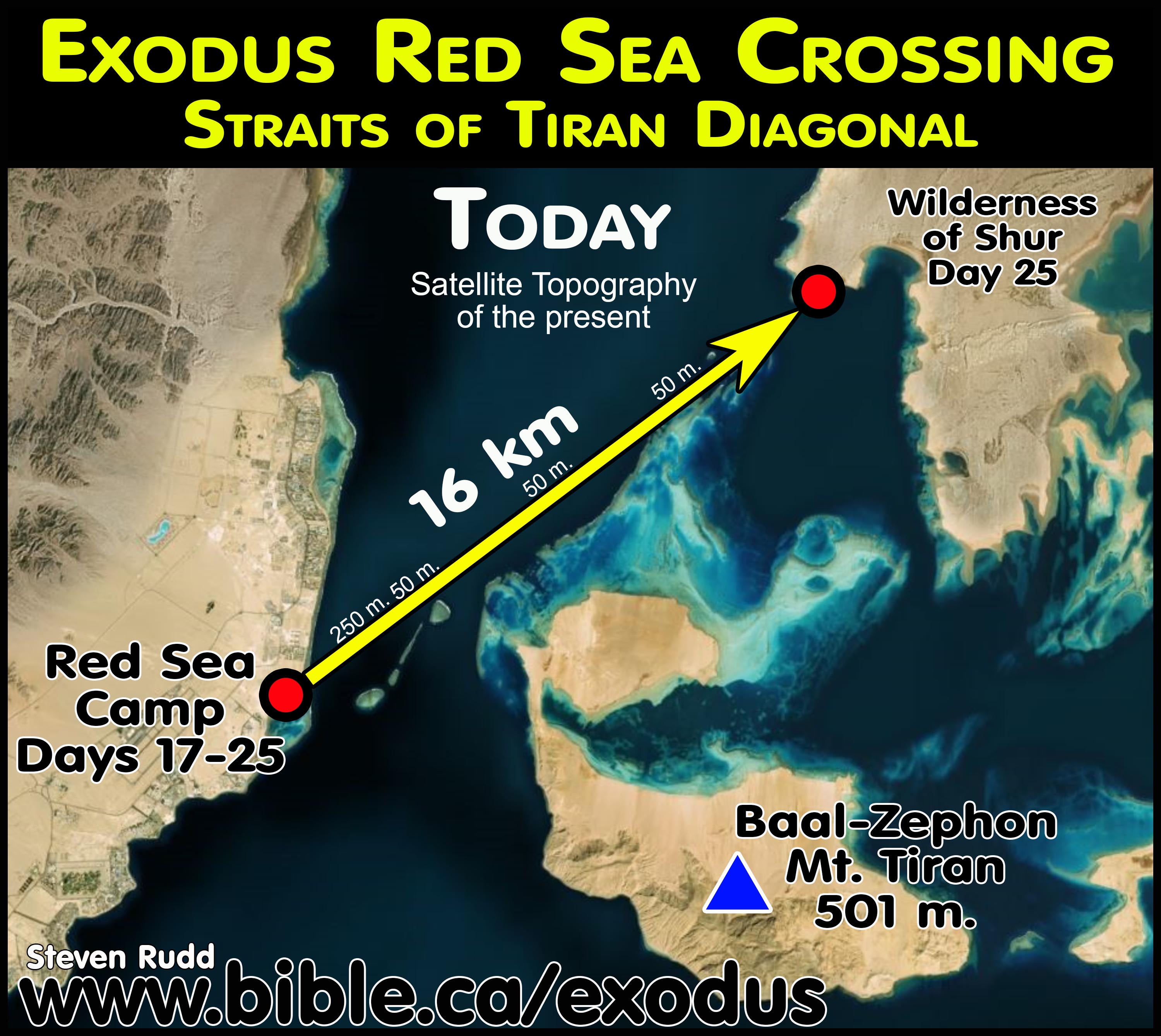
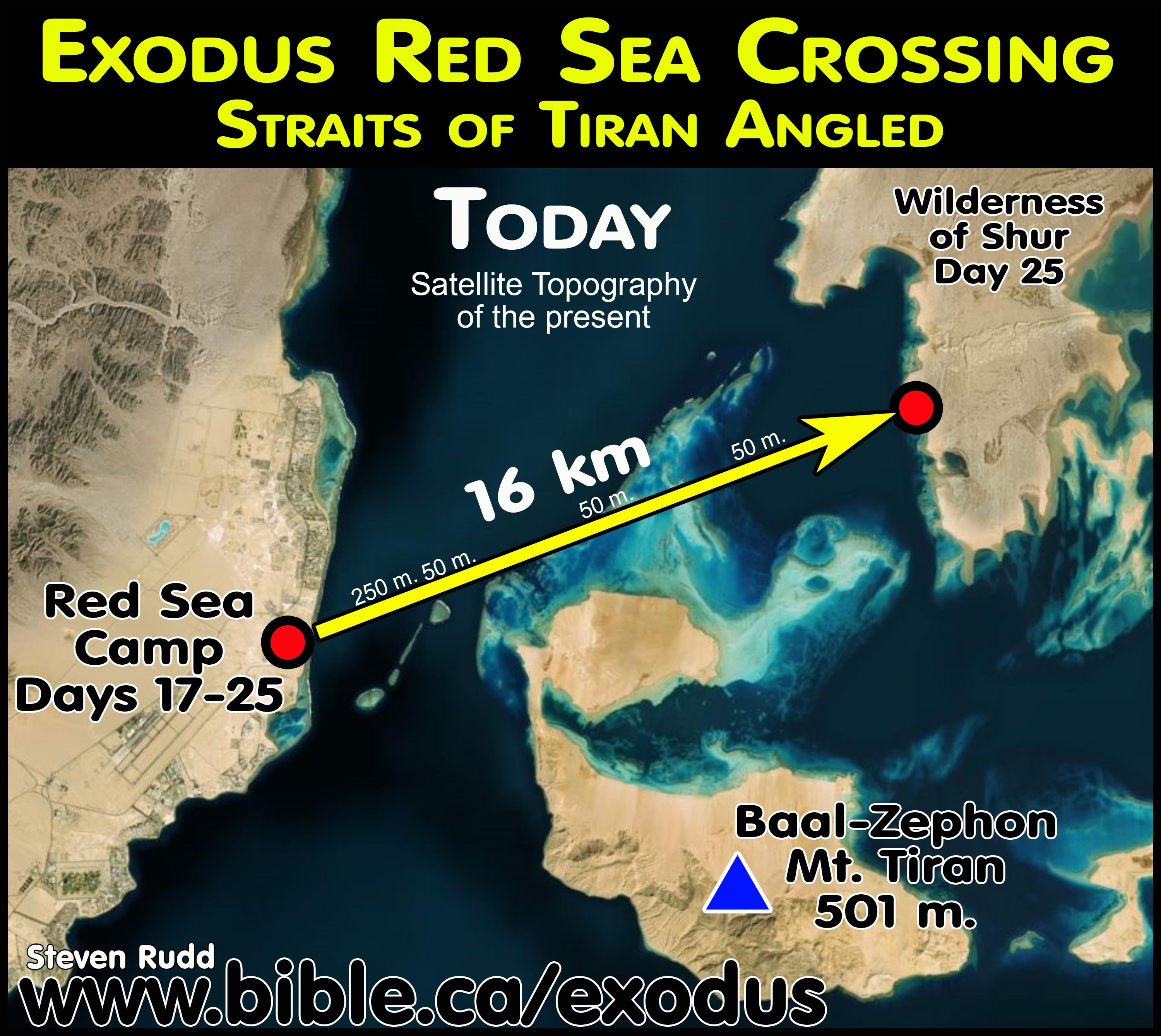
- It is 500 km from Goshen to the far side of the Straits of Tiran including the Etham backtrack. From Goshen to the Etham backtrack is 436 km. It is 24 km from Etham to the final Red Sea Camp and the crossing is 16 km.
- Israel arrived at the Red Sea Camp on day 17 and waited 7 more days for Pharaoh to arrive by horse with his chariots on day 24. 17 travel days produces an average daily distance of 29 km per day for the full 500 km trip. Israel traveled day and night and had supernatural help from God so they would not stumble at any time: Isaiah 63:11-14.
- Pharaoh made the 400 km trip from Egypt in 7 days and arrives on day 24 but the angel keeps the Egyptian army at bay until after Israel crossed the Red sea.
- All night of day 24 God parts the sea and uses the wind to dry the seafloor.
- On the morning of Sunday Day 25 Israel begins the 16 km crossing of the Red Sea
- The first 2 km of crossing the Red sea the depth reaches 250 meters, after that for the next 14 km the depth is only 50 meters.
- On day 25, with a 1 km wide track travelling 4 km per hour, it would take one person 4 hours to make the 16 km crossing.
- In 1446 BC, in the afternoon of day 25, the waters “backtracked” (same word used at Etham) and pharaoh’s army was drowned.
- Thutmoses III never entered the Red Sea and died in 1441 BC. Thutmoses III had conducted a series of 17 annual military campaigns up to 1446 BC and then they STOPPED.
3. The positioning of the camp of Israel:
|
Geographic reference |
Israelite Camp: Exodus 14:2,9 |
Israelite Camp: Num 33:7 |
|
Pi-hahiroth "mouth of water" |
before Pi-hahiroth |
turn back to Pi-hahiroth |
|
Migdol "watchtower" |
between Migdol and the sea |
camped before between Migdol |
|
Baal-zephon (idol Baal) |
camp in front of Baal-zephon, opposite it |
Pi-hahiroth faces Baal-zephon |
a. Exodus 14:2: "Tell the sons of Israel to turn back and camp before Pi-hahiroth, between Migdol and the sea; you shall camp in front of Baal-zephon, opposite it, by the sea.
b. Numbers 33:7: They journeyed from Etham and turned back to Pi-hahiroth, which faces Baal-zephon, and they camped before Migdol.
c. Pi-hahiroth means a "mouth of water" in Hebrew. Notice that "Pi-hahiroth faces Baal-zephon" in Num 33:7. If you look at the "mouth" it indeed faces Baal-zephon!
- Understanding the Etham Backtrack:
- The Hebrews came down the 18 km wide coastal flatlands (“The Exodus Highway) and passed the Egyptian military "Migdol" tower that served as a three-way lookout point for the Gulfs of Aqaba, Suez and Arabia. With the Egyptian lookouts watching, Israel passed right by them travelling towards Etham where they stopped because of the high mountain range.
- On way to Etham, Israel passes directly over the spot of the final Red Sea camp, but must first camp at Etham, then be told by God to “backtrack”.
- Scripture says that Israel came to a dead end at Etham, then God told them to “backtrack” and retrace their steps and camp directly beside the "Migdol" in order for Pharaoh to say, "Now the Lord spoke to Moses, saying, "Tell the sons of Israel to turn back and camp before Pi-hahiroth, between Migdol and the sea; you shall camp in front of Baal-zephon, opposite it, by the sea. "For Pharaoh will say of the sons of Israel, 'They are wandering aimlessly in the land; the wilderness has shut them in.' "Thus I will harden Pharaoh's heart, and he will chase after them; and I will be honored through Pharaoh and all his army, and the Egyptians will know that I am the Lord." And they did so." Exodus 14:1-4
- As Israel started coming back towards the Migdol, the Egyptians in the watchtower sent a message to Pharaoh by messenger pigeon which arrived in 4 hours. Pharaoh assembles his 600 choice chariots and started pursuing Israel.
- Meanwhile, the Hebrews camped directly under the Migdol watchtower for about 8 days.
- When Pharaoh arrived, the pillar of fire came between Israel and the Army.
5. Two miracles were involved in parting the Red Sea. First, God’s miraculous power to keep the waters parted before and during the crossing. Second, the wind miracle to rapidly dry the sea floor.
a.
The waters parted almost instantly through God’s unspeakable power, but it
took over night for the wind to dry to seafloor. Once the ground was dry the
wind stopped blowing and Israel crossed the Red Sea in quiet tranquility. Once
the lack of wind lured the Egyptians into the Red Sea, God once again created a
wind storm, withdrew the supernatural forces holding the walls of water up and
the Egyptians sank 1300 meters to the bottom of the Red Sea on either side of
the Straits of Tiran. This refutes the naturalistic wind theory of Carl Drews
in his Red Sea crossing at Menzaleh/Tanis Lake (Carl Drews)
b. Exodus 14:21-22 has led some to wrongly conclude the wind was the primary and only force that divided the water. Those who say wind was the only force God used to hold the walls of water up need to try walking through a tornado or in a category 5 hurricane.
c. If Ex 14:21-22 teaches the sea was parted by supernatural wind alone, then Ex 14:16 teaches Moses’ staff alone parted the Sea and Exodus 14:26-27 teaches Moses’ staff alone caused the sea to return. Wind was the primary drying agent but not the primary water dividing agent of the Red Sea crossing. The wind force accompanied the primary forces that divided the sea. There could not be any wind blowing when Israel crossed the Red Sea through the two walls of water that were likely 300 meters high.
d. Notice in Ex 15:10 that the wind began to blow again as the water returned and drowned the Egyptians which indicates it had stopped blowing during the crossing. Through the night, there was a violent windstorm that stopped while Israel crossed then another windstorm began to drown the Egyptians. If wind were the force holding up the wall of water, God would stop the wind to make the waters return through the law of gravity. The proof wind was not holding up the water is the fact that God started up the wind after Israel crossed to destroy the Egyptian army when the water walls collapsed. It was the cessation of supernatural forces that made the waters return to normal and no wind was needed.
e. God’s power divided the sea, partly through wind but mainly through unspeakably complex forces to maintain two perfectly parallel walls of water 300 meter. It is impossible for hurricane force winds, energized by God, to part the sea without a secondary supernatural force to prevent human bodies from being blown away. Everyone therefore must agree at double miracle was involved to create the wall of water and have Israel walk through such a wind tunnel. Those who say wind alone was the force to divide the sea require a second miracle to shield the wind from the children and transportation carts. Just imagine small children walking inside such a wind tunnel.
f. Wind is a measurable and predicable natural force and as it moves it creates pressure on one side (to part the sea) and a vacuum on the other. Both the pressure forces and vacuum forces of wind would greatly exceed any possible way for the 3 million Hebrews to walk through the Red Sea without another miracle that kept them from literally being blown away. The laws of physics require a wind force vectored directly towards both the walls of water and perpendicular to the path of travel of the Hebrews as they crossed.
g. Such high wind forces would create a huge water spray that would soak the dry ground. The water spray from Victoria Falls in Zimbabwe or Niagara Falls in Canada from 500 meters away would be dwarfed by the spray from the Red Sea crossing if wind was the primary force to part the waters. It would be like walking through an automatic car wash.
h. If the wind blows parallel to the walls of water, the full length of the 16 km crossing in one direction, it would not provide the required perpendicular forces to hold water up. Wind was how God dried the ground, not how he kept the waters parted. Wind speeds greatly exceeding a tornado would be required to keep water displaced and would send human bodies airborne.
6. The miracle of parting the Red Sea was a huge miracle demonstrating the eternal nature of God:
a. "The waters saw You, O God; The waters saw You, they were in anguish; The deeps also trembled. The clouds poured out water; The skies gave forth a sound; Your arrows flashed here and there. The sound of Your thunder was in the whirlwind; The lightnings lit up the world; The earth trembled and shook. Your way was in the sea And Your paths in the mighty waters, And Your footprints may not be known. You led Your people like a flock By the hand of Moses and Aaron." (Psalm 77:16–20)
b. "He divided the sea and caused them to pass through, And He made the waters stand up like a heap." (Psalm 78:13)
c. “You divided the sea before them, So they passed through the midst of the sea on dry ground; And their pursuers You hurled into the depths, Like a stone into raging waters." (Nehemiah 9:11)
d. "To Him who divided the Red Sea asunder, For His lovingkindness is everlasting," (Psalm 136:13)
e. "You divided the sea by Your strength; You broke the heads of the sea monsters in the waters." (Psalm 74:13)
f. "Was it not You who dried up the sea, The waters of the great deep; Who made the depths of the sea a pathway For the redeemed to cross over?" (Isaiah 51:10)
g. “For the Lord your God dried up the waters of the Jordan before you until you had crossed, just as the Lord your God had done to the Red Sea, which He dried up before us until we had crossed;" (Joshua 4:23)
h. “At the blast of Your nostrils the waters were piled up, The flowing waters stood up like a heap; The deeps were congealed in the heart of the sea." (Exodus 15:8)
i. "So when the people set out from their tents to cross the Jordan with the priests carrying the ark of the covenant before the people, and when those who carried the ark came into the Jordan, and the feet of the priests carrying the ark were dipped in the edge of the water (for the Jordan overflows all its banks all the days of harvest), the waters which were flowing down from above stood and rose up in one heap, a great distance away at Adam, the city that is beside Zarethan; and those which were flowing down toward the sea of the Arabah, the Salt Sea, were completely cut off. So the people crossed opposite Jericho. And the priests who carried the ark of the covenant of the Lord stood firm on dry ground in the middle of the Jordan while all Israel crossed on dry ground, until all the nation had finished crossing the Jordan." (Joshua 3:14–17)
j. "Come and see the works of God, Who is awesome in His deeds toward the sons of men. He turned the sea into dry land; They passed through the river on foot; There let us rejoice in Him!" (Psalm 66:5–6)
k. "When Israel went forth from Egypt, The house of Jacob from a people of strange language, Judah became His sanctuary, Israel, His dominion. The sea looked and fled; The Jordan turned back. The mountains skipped like rams, The hills, like lambs. What ails you, O sea, that you flee? O Jordan, that you turn back? O mountains, that you skip like rams? O hills, like lambs? Tremble, O earth, before the Lord, Before the God of Jacob, Who turned the rock into a pool of water, The flint into a fountain of water." (Psalm 114:1–8)
7. Pharaoh's army sank to the bottom like a stone in deep, mighty, raging waters! Exodus 15:5, 10
a. The Bible says that Pharaoh's army sank to the bottom of the sea like a stone, and later washed up on shore. "They went down into the depths like a stone. ... They sank like lead in the mighty waters. " Exodus 15:5, 10 "You hurled into the depths, Like a stone into raging waters." Nehemiah 9:11.
b. As God released the water, the surge would be like a 40-foot tsunami (wave) that would easily sweep the entire army off the 800-meter-wide land bridge into 1300-1450-meter-deep water immediately on either side. Pharaoh's army sank to the bottom like a stone in very deep, mighty, raging waters! It was a bad day for heavy body armor.
A. The Red Sea crossing is a type of water baptism by full immersion for salvation:
1. Water
baptism is essential to salvation. It is how we contact the blood of Christ and
are born again.

a. “He who has believed and has been baptized shall be saved; but he who has disbelieved shall be condemned." (Mark 16:16)
b. "Peter said to them, “Repent, and each of you be baptized in the name of Jesus Christ for the forgiveness of your sins; and you will receive the gift of the Holy Spirit." (Acts 2:38)
c. "‘Now why do you delay? Get up and be baptized, and wash away your sins, calling on His name.’" (Acts 22:16)
d. "Corresponding to that, baptism now saves you—not the removal of dirt from the flesh, but an appeal to God for a good conscience—through the resurrection of Jesus Christ," (1 Peter 3:21)
e. "Jesus answered and said to him, “Truly, truly, I say to you, unless one is born again he cannot see the kingdom of God.” Nicodemus said to Him, “How can a man be born when he is old? He cannot enter a second time into his mother’s womb and be born, can he?” Jesus answered, “Truly, truly, I say to you, unless one is born of water and the Spirit he cannot enter into the kingdom of God." (John 3:3–5)
2. The Red Sea crossing proves that Christian water baptism is by full immersion not sprinkling: 1 Cor 10:1-4
a. Israel started to cross the Red Sea with a wall of water on both sides and a vapour cloud over head.
b. This symbolized water baptism as full immersion.
3. Water
baptism is a reenactment ritual of the Red Sea crossing:

a. Just as the Red Sea saved Israel from the slavery of Egyptian bondage, water baptism saves us from the slavery of our sins.
b. When Israel is standing in the wilderness of Shur, Pharaoh’s army pursued Israel through the sea and God drowns the army by washing them into the 1450-meter-deep water on either side of the Straits of Tiran.
c. Israel rejoices knowing they are fully secure and safe.
d. When we confess that Jesus Christ is the risen saviour and we repent of our sins and then are immersed in water we too can rejoice in our salvation!
e. To rejoice in your salvation before being water baptized is like Israel rejoicing before they had crossed the Red Sea!
4. Baptized
into Moses and Baptized into Christ prove the essentiality of water baptism:

a. "For I do not want you to be unaware, brethren, that our fathers were all under the cloud and all passed through the sea; and all were baptized into Moses in the cloud and in the sea; and all ate the same spiritual food; and all drank the same spiritual drink, for they were drinking from a spiritual rock which followed them; and the rock was Christ." (1 Corinthians 10:1–4)
b. "For all of you who were baptized into Christ have clothed yourselves with Christ." (Galatians 3:27)
c. "Or do you not know that all of us who have been baptized into Christ Jesus have been baptized into His death?" (Romans 6:3)
d. "For by one Spirit we were all baptized into one body, whether Jews or Greeks, whether slaves or free, and we were all made to drink of one Spirit." (1 Corinthians 12:13)
B. The geology, topography, watershed and bathymetric data of the Gulf of Aqaba:
1. There are six “deeps” in the Gulf of Aqaba: (listed north to south)
a. Elat Deep: 950 meters
b. Aragonese Deep: 1800 meters
c. Arnona Deep: 1500 meters
d. Dakar Deep: 1300 meters
e. Tiran Deep: 1300 meters
f. Hume Deep: 1450 meters
2. Sixteen sedimentary beach fans:
a. There are at least 16 different sedimentary “beach fans” that have formed since the flood in 3298 BC on the west coast of the Gulf of Aqaba.
b. During rainfall, the watershed feeds a wadi system which washes sediment into the gulf forming “beach fans” that are continually increasing in size over time.
c. The largest of these “sediment fans” is the Nuweiba Beach. The large watershed area that exits through the Wadi Watir to Nuweiba has eroded massive amounts of sediment into the Gulf of Aqaba. Not only did this eroded sediment form the entire Nuweiba Beach fan area, it also created the natural “underwater land bridge” favored by some as a Red Sea crossing point. On the Saudi side of the Nuweiba Beach another series of wadis have infilled the Gulf as well.
d. Etham at Tiran sits on a sedimentary beach fan which, at the time of Moses, would be half the width we see today. Even so, the area was still large enough in 1446 BC to camp all 3 million Hebrews before they were told by God to “backtrack” to the final Red Sea camp where they waited 7 days for pharaoh to arrive.
3.
Natural underwater land bridge at Tiran is at 250-300 meters below sea
level.

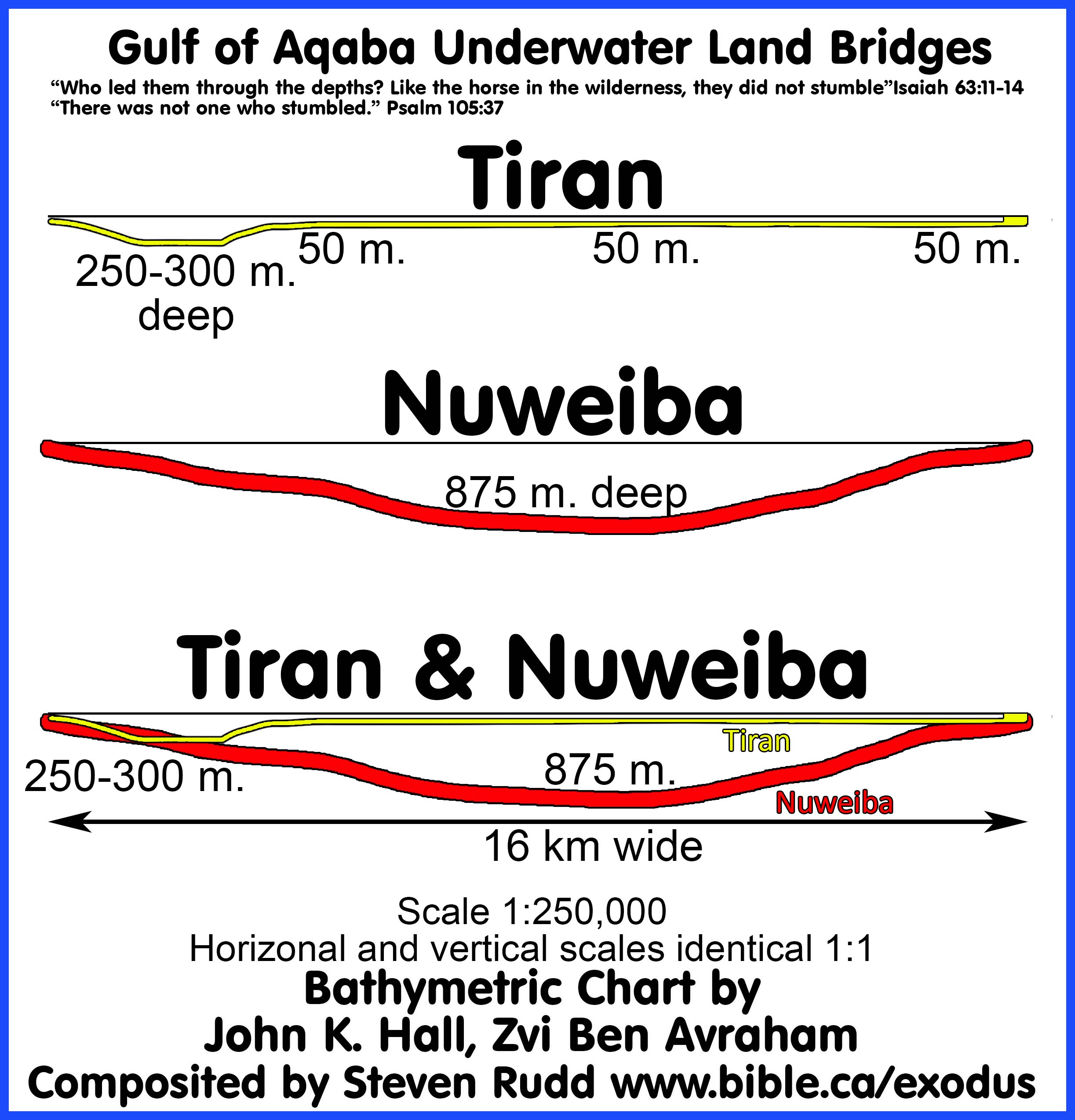
a. Today, the depth at Tiran is about 250 meters (800 feet) below sea level. Depths in this area range from 205 -300 meters deep.
b. As it exists today, the Tiran crossing point provides a gentle slope that dips to 250 meters the first 2 km, them back up to 50 meters for the remaining 12 km over a total distance of 16 km.
c. Three million Hebrews would have no problem crossing at Tiran in a lane that is up to 1 km wide for the first 4 km, then the lane widens to 3 km for the remaining 12 km as a single unit in less than 8 hours.
d. 3400 years ago, the topography and bathymetric slopes were certainly much different than what we see today. At the time of Moses, the coral reef between the Grafton and Enterprise shipping lanes probably didn’t exist. Tiran Island was likely connected with the mainland of Saudi Arabia but after millennia of erosion created the Island we see today. The Egyptian beach at Tiran was likely smaller in places where wadis flowed into the Gulf. All this would change the location and direction of the Red Sea crossing. The actual crossing at Tiran may have only been 5 km directly across to Tiran Island. It is very possible that the distances between the shorelines were only 5 km at the time of Moses. 3400 years ago, the distances, depths and slopes were likely different than what we see today in such a way to facilitate an easier crossing at the time of Moses.
e. Today however, our proposed crossing that dips to 250 meters below sea level is the equivalent of a 80-story building. Each person would have to climb down 80 flights of stairs for 2 km, then back up 80 flights of stairs another 2 km. This would make the crossing easy through the 250-meter walls of water on both sides for the first 4 km.
f. The slopes and distances of a Red Sea crossing at the straits of Tiran are perfect and offer no known problem.
g. God would have miraculously shaped the seafloor to fix any deficiencies in slopes or depths at the Tiran crossing.
4.
Natural underwater land bridge Nuweiba is at 875 meters below sea level.
a. Today, the depth at Nuweiba is about 875 meters (2900 feet) below sea level.
b. As it exists today, the Nuweiba crossing point provides a gentle slope that dips to 875 meters in the center of a 16 km total distance.
c. Three million Hebrews would have no problem crossing at Nuweiba in a lane that is up to 5 km wide for the full 16 km distance as a single unit in less than 6 hours.
d. 3400 years ago, the depths were certainly much greater and slopes much steeper than what we see today. There is impossible to shorten the distance between shorelines and the sediment washed into the Gulf from the wadi Watir over time would certainly mean the depths were greater at the time of Moses.
e. Today however, the 875 meters is the equivalent of a 290-story building. The CN Tower was once the tallest building in the world at 530 meters. Each person would have to climb down 290 flights of stairs for a distance of 8 km, then back up 290 flights of stairs another 8 km. While the slopes are not prohibitive at Nuweiba, this is a huge amount of energy for man, beast and cargo.
f. Today, the slope and terrain of the underwater land bridge at Nuweiba is entirely possible although other factors rule it out as the location of Red Sea crossing.
g. God would have miraculously shaped the seafloor to fix any deficiencies in slopes or depths at the Nuweiba crossing.
5.
Comparing Tiran vs. Nuweiba as candidate Red Sea crossing points:
a. Both Tiran and Nuweiba have comparable, gentle slopes.
b. Both Tiran and Nuweiba are a 16 km walk from one shore to the other.
c. Nuweiba is more than 3 times deeper than Tiran requiring 3 times the human energy. Tiran drops to only 250 meters below sea level and Nuweiba drops down to 850 meters.
d. At the time of Moses, the Tiran crossing may have only been 5 km long to if Tiran Island was connected to the mainland or if the landmass of the isthmus of Shur extended towards Tiran Island more than it does today. There are no ways to shorten the 16 km at the Nuweiba crossing.
6.
The Tiran crossing proposed by Rudd has three possible tracks because
the seabed and topography have certainly changed in 3400 years. There are
several optional crossing tracts, all of which have similar slope profiles and
are all 16 km long. A straight diagonal that starts on the Tiran beach just
north of the Enterprise pass to the shore of Saudi Arabia. This diagonal track
reduces the slope of the Enterprise pass and never rises above 50 meters below
sea level the entire crossing. The straight-line track may also have been
angled differently. A curved track also works well. Tiran Island may have
connected with the mainland at the time of Moses. Geologists, geographers, and
oceanographers all know that shorelines can look very different 3400 years ago.
If we remove the coral reef and connect Tiran Island to the Saudi Arabian shore
it creates a short 5 km Red Sea crossing that Israel could make in a few hours
walking 5 km per hour. We have shown several possible routing options of how
the Wilderness of Shur may have connected with Tiran Island. While this is
speculative it is not unrealistic. We simply do not know the exact crossing
track today but there are many options that are perfect fits.
7. Another possible route is directly across the Enterprise Passage across the coral reef then to mainland Saudi Arabia as we see it today. On either side of the reef there are two deeper sections known as the "Enterprise" and "Grafton" passages. The coral reefs are only 20 meters deep and is about 14 km long. These are one-way shipping lanes around the coral reef to access the Gulf of Aqaba. From modern nautical charts, we can see that the eastern "Enterprise Passage" is 205 meters deep and 800 meters wide and the western "Grafton Passage" is only 70 meters deep and 800 meters wide. A diver need go only 13 meters at deepest point on top of Jackson's Reef from the surface. From what we see today, a Red Sea crossing point was likely north of these two coral reefs.
|
|
|


8.
High resolution map of the Gulf of Aqaba with the Tiran and Nuweiba
crossings. The author first saw this map on the wall of Tel-Aviv university and
photographed it while dropping off feral bones excavated at Shiloh to be
examined by a professor who wrote us a Feral Bone report. This is the
high-resolution digital version of the AD 1978 Bathymetric map of the Gulf of
Aqaba by John K. Hall and Zvi Ben Avraham. Click on the map to view details.
C. Wooden Chariots and their wheels float, and contained no metal:

1. Movies often depict the cinematic fiction of chariot wheels slowly singing to the bottom immediately after the waters drowned the Egyptian army. Since chariots were made of wood they would simply float away. Chariots in the 18th Egyptian dynasty were not overlaid with metals except for ceremonial constructions never taken into war. In the exodus Egyptian army, the only possible chariot that contained any gold overlay, would have been of Thutmoses III, but he never entered the Red Sea with his chariot.
2. War chariots were made from 100% hardwood Tamarisk wood and chariot wheels contained no metal. Even the axle pins were wooden as witnessed in the chariot of King Tut.
3. Tamarisk is a dense wood that takes months to become waterlogged and sing to the bottom. This means that chariot wheels would immediately float to the surface and drift hundreds of kilometers before washing to shore or sinking to the bottom far away from the Red Sea crossing site.
4. 18th dynasty chariots were made of Tamarisk wood and floated quite well. Tamarisk is also called, salt-cedar, and tamarix. The chariots from King Tut’s tombs seen in museums are made entirely of wood and rawhide and contained no metal. Later period chariots used a few small metal pins to hold wooden parts together but even these chariots floated on top of the water and did not sink.
5. When 250-meter-high walls of water at the Red Sea at Tiran “backtracked” upon the Egyptian army on dry ground, the forces were likely sufficient to splinter the chariots into toothpicks and all the wheels would float to the surface. The leather harnesses that tethered the chariot to the horses would likely break and the entire chariot would float to the surface. If the chariot remained connected to the horse after drowning, the buoyancy of the chariot might keep the dead horse at the surface. If both chariot and horse sank to the bottom, the body of the dead horse would float to the surface through bacterial decay in about two weeks. Looking for remnants of pharaoh’s chariot wheels anywhere, including the shallow waters at Nuweiba, is absurd given they would float hundreds of kilometers.
6. The dense grain of hardwood slows down water logging. If they had any pitch coating (buoyancy neutral) that would slow down waterlogging even more. The waterlogged chariot wheel eventually sank far from the original location after months of drifting. Looking in the shallow waters of Nuweiba for chariot wheels is misguided.
7. Wood in water decays rapidly unless it is in a deep-water, cold, oxygen-depleted environment. While the Gulf of Aqaba has several deep zones up to 1450 meters beside the Straits of Tiran, it is still very unlikely that floating chariot wheels would become water-logged and sink in that location. Even if chariot wheels did sink in one of these “deeps” it would be buried under several meters of sediment after 3400 years. It is also absurd to suggest that shallow water coral formations photographed today, which vaguely look like a chariot wheel, had originally formed around the wooden chariot wheel which has long since decayed leaving a coral outline. Coral is a living animal that constantly changes shape over time with growth rates of 2-10 cm per year. Coral formations today will look quite different even 10 years in the future.
8. Both wheels and the connecting axle of a chariot were 100% made of wood and contained no metal parts at the time of the exodus. Unicorn Internet Archaeologists (UIA) who show pictures of coral formations in shallow water as proof of the Nuweiba Red Sea crossing must be ignored as fake news. None of these coral formations were ever brought to the surface. In the few short years since these coral formations were photographed, they have changed and are now broken up by natural processes so that they no longer look the way they originally did. The underwater photos of random coral formations used by these UIA’s are no more scientific than photographing random clouds in the shape chariot wheels. Using this fake evidence of chariot wheel shaped coral formations at the Nuweiba beach brings well deserved ridicule and scorn from the professional world upon Christians in general and are a disservice to the cause of Jesus Christ.
9. Sources:
a. “The Egyptian chariots were of light and simple construction, the material employed being wood, as is proved by sculptures representing the manufacture of chariots. The axle was set far back, and the bottom of the car, which rested on this and on the pole, was sometimes formed of a frame interlaced with a network of thongs or ropes.” (Dictionary of the Bible, James Hastings, Chariot)
b. “Pictorial evidence from numerous reliefs plus several actual chariots from Egyptian tombs present a reasonably clear picture of how these war machines were made. In contrast to wheeled wagons used earlier and heavier chariots used later in parts of the ancient Near East, most chariots during this period were light vehicles built to carry two men. They were made mostly of bent hardwood and leather, with a few metal parts and wrappings of birch bark to repel moisture. … The Egyptians made their chariots from elm and tamarisk wood.” (Warfare in the Old Testament, Boyd Seevers, p129, 2013 AD)
c. “Professor Yigael Yadin maintains that during the earlier part of the 18th Dynasty, the Egyptian chariot was "exactly like the Canaanite chariot" both were constructed of light flexible wood, with leather straps wrapped around the wood to strengthen it, and both utilized wheels with four spokes. In Yadin's eyes the four-spoked wheel is diagnostic for dating purposes; it is restricted to the early period of the 18th Dynasty. It remained in vogue, he says, until the reign of Thutmose IV, when "the Egyptian chariot begins to shake off its Canaanite influence and undergo considerable change." Yadin believes that the eight-spoked wheel, which is seen on the body of Thutmose IV's chariot,8 was an experiment by the Egyptian wheelwrights, who, when it proved unsuccessful, settled thereafter for the six-spoked wheel. In short, "So widespread and meticulous is the delineation of the number of wheel spokes on chariots depicted on Egyptian monuments that they can be used as a criterion for determining whether the monument is earlier or later than 1400 B.C. … A chariot scene from the tomb of Ken-Amun (dated to the reign of Amenhotep II) shows a partially obliterated chariot. Four-spoked wheels are invariably depicted with the spokes in a 12, 6, 3, and 9 o'clock position, but in this scene the two visible spokes point toward 12 and 4 o'clock; this indicates a six-spoked wheel." (Observations on the Evolving Chariot Wheel in the 18th Dynasty, James K. Hoffmeier, Journal of the American Research Center in Egypt, Vol. 13, p43, 1976 AD)
d. “According to the evidence presented here, the six-spoked wheel is regularly portrayed in the chariots used by monarchs after Thutmose IV, the sole exception being the talatat scene from the Amarna period mentioned above. However, contrary to Yadin's position, the six-spoked wheel is found before 1400 B.C. But he is basically correct in stating that the six-spoked wheel is consistently shown on chariots after 1400 B.C. Yadin's explanation for the shift in the number of wheel spokes is hardly convincing. The Egyptians were certainly jingoistic, but it is stretching the point to believe that they would alter the number of wheel spokes merely to "shake off Canaanite influences," and thereby assert their nationalistic identity. They were eminently practical, and we must seek a practical reason for the change. The six-spoked wheel from the reign of Amenhotep II suggests that the shift must have begun even earlier. Thutmose III, Amenhotep IFs predecessor, launched at least military campaigns into Syria-Palestine; one might surmise that in these circumstances the Egyptian chariot would undergo certain changes in order to achieve maximum performance. Unfortunately we have no battle scenes with chariots in action until the time of Tutankhamun. Before this, chariots are limited to hunting, domestic, and procession scene.” (Observations on the Evolving Chariot Wheel in the 18th Dynasty, James K. Hoffmeier, Journal of the American Research Center in Egypt, Vol. 13, p44, 1976 AD)
e. "chariots also contained a few metal parts, usually bronze pins to fasten various assemblies. Metal was kept to a minimum to reduce weight" Seevers, p. 64.
10. See also:
a. Chariots and Related Equipment from the Tomb of Tutankhamun, M. A Littauer, p92-94,102, 1985 AD
b. Wheeled Vehicles and Ridden Animals in the Ancient Near East, M. A. Littauer, J. H. Crouwel, p81, 1979 AD
D. Glen Fritz distorts and misrepresents the slope and transect of the Straits of Tiran crossing:
1.
Just you thought the misinformation on the underwater land bridge
transect slopes at Nuweiba could not get any worse with Ron Wyatt’s distorted
depth charts, Glen Fritz, with a PhD in geography, outdoes Ron Wyatt by
publishing his own set of distorted depth charts for both Nuweiba and the
Straits of Tiran. Fritz’s PhD 2006 AD dissertation was called “The Lost Sea of
the Exodus”. He turned his PhD dissertation into a book of the same title in
2007 AD, then published the second edition of in 2016 AD. The distorted slope
transect chart discussed here comes from Glen Fritz, “The Lost Sea of the
Exodus”, p274, 2016 AD and he used this same graphic in the Red Sea Miracle II
movie series directed by Tim Mahony in 2020 AD. Fritz presented the graphic in
the movie as an optical comparison of the slopes even though he said directly
below the graphic in his book, “The depths and distances in these graphs are
not drawn to scale” (Lost Sea, p274). Steve Rudd even told Glen Fritz 4 months
before the movie came out, that the image was seriously distorted to no avail.
Glen Fritz mislead his movie viewers who would wrongly conclude, based directly
upon his misleading visual graphic, that the Tiran slopes appear to be a serious
problem and the Nuweiba slopes are clearly superior. Fritz compounds the
confusion generated by Ron Wyatt surrounding the two underwater land bridges on
the Gulf of Aqaba rather than clarify the actual facts. Red depths [-125 m] and horizontal lines [_____]
and distances [16 km] are not part of the
original charts but were added by Rudd to assist in clarity.
![]()
2. Distortions, errors and omissions in Glen Fritz slope transects:
a. The slopes of the underwater land bridges at Nuweiba and Tiran present no impediment to the Red Sea crossing. Both slopes are very similar. The difference is that the Nuweiba is over 3 times deeper than Tiran requiring 3 times the human effort.
b. Bottom levels are not indicated in either chart for Nuweiba (875m.) or Tiran (250m.) creating an illusion that Nuweiba is slightly deeper that 750 meters, when it is actually greater than 850 meters.
c. The graphic for the Nuweiba transect slope uses different vertical and horizontal scales than in the Tiran graphic even though they are presented side by side as apples to apples comparisons. Fritz’ vertical sea level depth scale for Nuweiba is 0 to -875 but for Tiran the bottom level is about 275 meters. The horizontal scale for Nuweiba is 19 km but for Tiran it is only 8 km even though they are presented side by side as apples to apples comparisons. Fritz presents a transect chart for Tiran but never specifies exactly where the data is drawn from, leaving it again, to the reader to guess. He describes the Tiran crossing in the movie as a “roller coaster” route, which clearly does not describe Rudd’s route at all.
d.
Fritz did not use a 1:1 horizontal to vertical scale which introduces
distortion and changes the slope of the bottom level. Fritz used a
horizontal/vertical scale of 1:2 for Nuweiba and 1:7 for Tiran. That makes the Tiran crossing look 7 times steeper than it
really is. It also makes the Nuweiba crossing look twice as steep as it
really is. Correcting his two charts onto the same 1:1 scale, his slopes are
almost a perfect match to what Rudd calculated for both Nuweiba and Tiran.
Fritz’ problem was not in his data, but his misleading presentation of the data
with conflicting and distorted scales for visual presentation to the general
public. He needs to put out a disclaimer now before the Unicorn Internet
Archaeologists (UIA) start misusing his materials in showing how superior the
slope of the Nuweiba crossing is compared to the Tiran crossing.
e.
Fritz misreads the bathymetric chart by Hall and Ben-Avraham and
miscalculated the distance of his own Nuweiba crossing at 19 km when in fact
the shows it is only 16 km. This distance is confirmed in Google Earth pro. To
correct his defective graphic, it must be compressed horizontally from 19 km to
16 km which has the effect of making the slopes steeper than he represented.
Strangely, in other places Fritz contradicts himself by saying the crossing is
16 km, but on the chart he used in the movie, he confused his audience again by
labelling the distance as 19 km. The Nuweiba and Tiran crossing are both 16 km.
f.
Fritz’ 8 km track starts from the Tiran beach, passes through the
Enterprise pass, over top of the coral reefs which are 50 meters above sea
level, then through the Grafton pass and ends at Tiran Island. The Tiran
crossing proposed by Rudd has three possible tracks because the seabed and
topography have certainly changed in 3400 years. There are several optional
crossing tracts, all of which have similar slope profiles and are all 16 km
long. A straight diagonal that starts on the Tiran beach just north of the
Enterprise pass to the shore of Saudi Arabia. This diagonal track reduces the
slope of the Enterprise pass and never rises above 50 meters below sea level
the entire crossing. The straight-line track may also have been angled
differently. A curved track also works well. Tiran Island may have connected
with the mainland at the time of Moses. We simply do not know the exact
crossing track today but there are many options that are perfect fits.
g. The Glen Fritz marks sea level for Tiran at -50 meters. A water depth chart must mark sea level at zero. Apparently, Fritz marked the zero meters (sea level) at the top of the coral reef which he suggests towers 50 meters above sea level. When he marks sea level at -50 meters and doesn’t label the bottom level, it is impossible to know just how deep he considers the Tiran transect.
h. The two slope charts Glen Fritz used in his book and the Red Sea Miracle II movie are so riddled with errors that they are worthless. In “APPENDIX 6: GULF OF AQABA BATHYMETRY” Fritz goes into great detail to explain how he created his two defective maps (Lost Sea, p272). It all looks so professional and convincing in print and the silver screen, until you examine the details and gasp.
i.
British admiralty nautical depth chart 12 is older and shows the depths to
be around 765 meters but is included here for historical purposes.

j.
Ron Wyatt’s famous slope chart of Nuweiba which was distorted in the
horizontal to vertical scales in the ration of 10:1 which means the vertical
scale was 10 times the size of the horizontal scale. His horizontal scale was 1
km, but his vertical scale was 100 meters. Wyatt’s chart is from "The
Exodus Case" p190, by Lennart Moller and "The exodus Conspiracy"
movie. Glen Fritz follows in Wyatt’s footsteps by publishing equally distorted
slope charts for both Nuweiba and Tiran. Instead of mopping up Wyatt’s mess,
Fritz further muddies the water.

E. Daily calendar of events from Goshen to the Red Sea crossing: Days 1-25
See also: Travel times, distances, days of the week
|
Mon |
Tue |
Wed |
Thurs |
Fri |
Sat |
|
|
- |
- |
- |
Nisan 14: Passover lambs killed before sunset and eaten on Nisan 15 Wed evening. |
Day 1 Nisan 15: Departed in Daylight Num 33:3 |
2 |
3 Start counting 7 Sabbaths for Pentecost |
|
4 |
5 |
6 |
7 |
8 |
9 Succoth Overnight camp |
10 day 8 of Pentecost Nisan 24 |
|
11 |
12 |
13 |
14 |
15 Migdol |
16 Etham: Nisan 30 |
17 Iyar 1 |
|
18 camped at Red Sea |
19 Iyar 3 at Red Sea |
20 camped at Red Sea |
21 camped at Red Sea |
22 camped at Red Sea |
23 camped at Red Sea |
24 camped at Red Sea |
|
Iyar 9, saved and Shadow of First Fruits Lev 23:10-12 |
Day 1 after crossing |
28 Marah Day 3 after crossing |
29 Elim |
30 Iyar 14 Day 5 from Red Sea Crossing |
Wilderness of Sin. Ex 16:1. Day 6 from Red Sea Crossing |
F. Travel Itinerary, distances, and speeds from Goshen to Red Sea:
See also: Travel times, distances, days of the week
1. Itinerary from Goshen to the Straits of Tiran
|
Itinerary from Goshen to Red Sea Crossing at Tiran |
||||
|
Bible texts |
Day # from Red Sea |
Weekday |
distance from last stop |
|
|
Goshen to Succoth |
Exodus 12:37; 13:20; Numbers 33:5-6 |
1-9 |
Thursday- Friday |
240 km |
|
Etham: 460 km. (Passes Red Sea Camp at 436 km then 24 km to Etham) |
Exodus 14:1-4: 13:20; Numbers 33:6-8 |
10-16 |
Saturday – Friday |
220 km |
|
Red Sea Camp: 484 km |
Exodus 14:1-4 |
17-24 |
Saturday-Saturday |
24 km |
|
Cross Red sea: 500 km |
Exodus 14:13-31 |
25 |
Sunday |
16 km |
|
|
|
|
Total |
|
2. Daily rates of travel from Goshen to Tiran:
|
Calculating rates of travel from Goshen to Tiran |
|||||
|
Trip |
Distance |
Total days |
Camp days |
Travel days |
Daily rate of travel |
|
Goshen to Red Sea (including
Etham backtrack and Red Sea crossing) |
500 km |
24 |
7 |
17 |
29 km/day 18 miles/day |
|
Etham backtrack distance from the camp by the Red Sea at the crossing point to Etham and back again (24 km x 2) |
48 km |
- |
- |
- |
- |
|
Red Sea Crossing at Tiran (16 km included in Goshen to Red Sea 500 km) |
16 km |
1 |
- |
1 |
16 km/day 10 miles/day |
|
Red Sea to Sinai |
200 km |
22 |
11 |
11 |
18 km/day 11 miles/day |
|
Goshen to Sinai (including Etham backtrack 44 km and Red Sea crossing 16 km) |
700 km |
47 |
18 |
29 |
24 km/day 14 miles/day |
|
On day 17 when Israel backtracks from Etham, a message from Pharaoh's military "Migdol" to Egypt by homing pigeon at 80 km/hour (average speed is 100 km/hour): "They are moving aimlessly and the wilderness at Etham has shut them in." |
400 km |
5 hours
4 hours |
- |
- |
80 km/hr. 48 miles/hr.
100 km/hr. 62 miles/hr. |
|
On day 18 Pharaoh's army begin pursued Israel with horses and 600 choice chariots (and other standard chariots for a total perhaps of 2000) from Egypt to where the angel stopped them. (Ex 14:6-9) |
400 km |
7 |
0 |
7 |
57 km/day 34 miles/day |
|
Herodotus (450 BC): Mediterranean to Gulf of Suez |
150 km |
4 |
- |
- |
38 km/day |
G. Maps and photos
|
Aerial view |
|
|
Pi-Hahiroth looking towards the Migdol |
|
|
Pi-Hahiroth looking towards Etham |
|
|
looking from Baal-Zephon, the pagan cult mountain that was a center for Baal worship |
|
|
After they crossed the Red Sea they entered the wilderness of Shur |
|
|
How the mountains of the wilderness "shut them in" Ex 14:2 |
|
|
British admiralty nautical depth chart-12
(Click on photo for high resolution) |
|
|
British admiralty nautical depth chart 801 (inset) (Click on photo for high resolution) |
|
|
Depths of the crossing according to British admiralty nautical depth chart 801 |
|
|
Photos of the reefs |
|
|
Shipwreck on coral reef in the Straits of Tiran at low tide. |
|
|
View from the shore where Israel camped for 8 days. |
|


Learn More:
![]() Miracles
of the Exodus and Red Sea Crossing
Miracles
of the Exodus and Red Sea Crossing
![]() Travel
times, distances, days of the week
Travel
times, distances, days of the week
![]() Excluding
various exodus routes, Red Sea crossing point candidates and choices for Kadesh
Barnea
Excluding
various exodus routes, Red Sea crossing point candidates and choices for Kadesh
Barnea
By Steve Rudd: Contact the author for comments, input or corrections.
