Strabo 15 AD (Greek geographer)
Introduction:
- Strabo was a Greek geographer who lived from 64 BC to 24 AD. Maps have been constructed from his writings, "Geography" and like all his predecessors, Eratosthenes, Herodotus, Hesiod and Hecataeus.
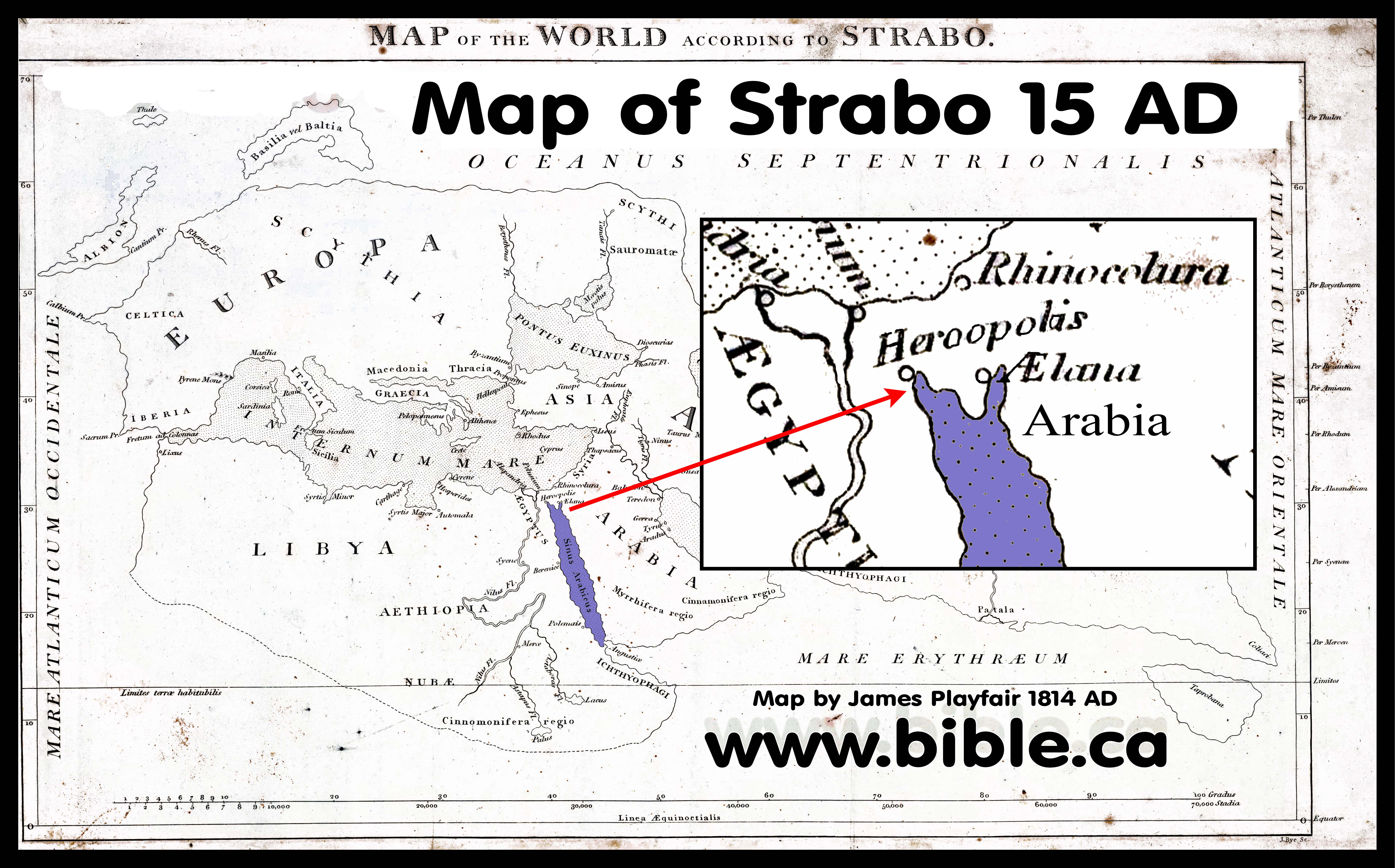
- Strabo (15 AD) is one of the few ancient cartographers who understood the gulf of Aqaba and gives us great insight into how Apostle Paul and Josephus viewed the Sinai Peninsula as NOT part of Arabia: "There is said to be a passage thence across, of 1260 stadia, to the city Aila (Aelana) [Elat], situated on the innermost recess of the Arabian Gulf [Red Sea]. This recess has two branches, one, in the direction of Arabia [south of Gulf of Aqaba] and Gaza [north of Gulf of Aqaba], is called Ailanites [Gulf of Aqaba], from the city upon it; the other is in the direction of Egypt [Gulf of Suez], towards Hereopolis, to which from Pelusium is the shortest road (between the two seas). (Strabo, Geogr. 16.2.30)
- In the mind of Strabo, Josephus and Paul, Arabia was north Saudi Arabia and never the Sinai Peninsula. Notice Strabo locates Arabia SOUTH of the gulf of Aqaba. Strabo clearly differentiates between "Arabia proper" located in north Saudi Arabia east to Babylon and even differentiates Arabia with "Arabia Felix" (the southwestern coast of the Arabian Peninsula)
- Strabo defines Arabia proper as being Transjordan: "Above [ie to the east: East-up map] Judæa and Cœle-Syria, as far as Babylonia and the river tract, along the banks of the Euphrates towards the south, lies the whole of Arabia" (Strabo, Geography 16.3.1)
- Strabo says Arabia begins from Babylon and goes west through the Arabian desert. "ARABIA commences [begins] on the side of Babylonia with Mæcene. In front of this district, on one side lies the desert of the Arabians, on the other are the marshes opposite to the Chaldæans, formed by the overflowing of the Euphrates, and in another direction is the Sea of Persia." (Strabo, Geography 16.4.1)
- Strabo defines "Arabia" as being Transjordan in distinction to "Arabia Felix": "I return to the opinions of Eratosthenes, which he next delivers respecting Arabia. He is speaking of the northern and desert part, lying between Arabia Felix, Cœle-Syria, and Judæa, to the recess of the Arabian Gulf." (Strabo, Geography 16.4.2)
- Strabo defines Arabia proper as being Transjordan between the main southern section of the Red Sea south of the Straits of Tiran and the Persian gulf: "When we were describing Arabia, we included in the description the gulfs which compress and make it a peninsula, namely the Gulfs of Arabia [section below the tri-intersection of the Gulfs of Suez, Aqaba and Arabian] and of Persis [Persian gulf near Babylon]. (Strabo, Geography 17.1.1)
- This provides insight into Josephus' and Paul's use of Arabia in the time they lived. The location of Arabia proper really hasn't ever changed, even with the annex of the Sinai Peninsula in 106 BC where it was formally labelled Arabia by the Romans: "It was not until 106 ad that the Romans officially annexed Nabatea and the “area around Petra” (Millar, Roman Near East, 94). Eventually, Rome extended their territory as far as Meda’in Saleh—300 miles south of Petra. Rome designated three sub-regions within Arabia: Arabia Petraea (Sinai and the old territory of Nabatea), Arabia Felix (the southwestern coast of the Arabian Peninsula), and Arabia Deserta (roughly the rest of Arabia). The Romans would control Arabia until the rise of the Islamic Arabian Empires of the seventh century." (Lexham Bible Dictionary, Arabia, 2016 AD)
- Strabo does have a good working knowledge of Israel. He is the first geographer to give Israel mention.
- When you read Strabo's "Geography" it is clear that we had before him all the maps and notes of his predecessors. In fact, without Strabo, who quotes Eratosthenes, Hesiod, Herodotus, Hecataeus, we might never have known what they wrote! Strabo repeats the errors of Eratosthenes, Herodotus, Hesiod and Hecataeus by making Goshen the boundary of Egypt and Arabia.
A. What Strabo said about the world map:
- After Mesopotamia come the countries this side of the Euphrates. These are: the whole of Arabia Felix (which is bounded by the whole extent of the Arabian Gulf and by the Persian Gulf), and all the country occupied by the Tent-Dwellers and by the Sheikh-governed tribes (which reaches to the Euphrates and Syria). Then come the peoples who live on the other side of the Arabian Gulf and as far as the Nile, namely, the Ethiopians and the Arabs, and the Egyptians who live next to them, and the Syrians, and the Cilicians (including the so called "Trachiotae"), and finally the Pamphylians. (Strabo, Geography 2:5:32)
- "Above Judaea and Coelê-Syria [east of Dead Sea] , as far as Babylonia and the river-country of the Euphrates towards the south, lies the whole of Arabia, with the exception of the Scenitae in Mesopotamia. Now I have already spoken of Mesopotamia and the tribes that occupy it; but as for the parts on the far side of the Euphrates, those near its outlets are occupied by Babylonians and the tribe of the Chaldaeans, of whom I have already spoken; and of those parts that follow after Mesopotamia as far as Coelê-Syria [east of Dead Sea] , the part that lies near the river, as well as Mesopotamia, is occupied by Arabian Scenitae, who are divided off into small sovereignties and live in tracts that are barren for want of water. These people till the land either little or none, but they keep herds of all kinds, particularly of camels. Above these people lies an extensive desert; but the parts lying still farther south than their country are held by the people who inhabit Arabia Felix, as it is called. The northern side of Arabia Felix [Near Midian] is formed by the above-mentioned desert, the eastern by the Persian Gulf, the western by the Arabian Gulf, and the southern by the great sea that lies outside both gulfs, which as a whole is called Erythra. [Red Sea] (Strabo, Geography 16:3:1)
- "Now the Persian Gulf is also called the Persian Sea; and Eratosthenes describes it as follows: its mouth, he says, is so narrow that from Harmozi, the promontory of Carmania, one can see the promontory at Macae in Arabia; and from its mouth the coast on the right, being circular, inclines at first, from Carmania, slightly towards the east, and then towards the north, and, after this, towards the west as far as Teredon and the outlet of the Euphrates; and it comprises the coast of the Carmanians and in part that of the Persians and Susians and Babylonians, a distance of about ten thousand stadia. I have already spoken of these peoples.(Strabo, Geography 16:3:2)
- Along the whole of the coast of the Red Sea, down in the deep, grow trees like the laurel and the olive, which at the ebb tides are wholly visible above the water but at the full tides are sometimes wholly covered; and while this is the case, the land that lies above the sea has no trees, and therefore the peculiarity is all the greater. Such are the statements of Eratosthenes concerning the Persian Sea, which, as I was saying, forms the eastern side of Arabia Felix. (Strabo, Geography 16:3:6)
- This is Strabo's account in 15 AD of what Eratosthenes said about Arabia: "But I return to Eratosthenes, who next sets forth his opinions concerning Arabia. He says concerning the northerly, or desert, part of Arabia, which lies between Arabia Felix [Yemen] and Coelê-Syria [east of Dead Sea] and Judaea, extending as far as the recess of the Arabian Gulf, that from the City of Heroes, [Heroönpolis or Goshen] which forms a recess of the Arabian Gulf near the Nile, the distance in the direction of the Petra of the Nabataeans to Babylon is five thousand six hundred stadia [1120 km, actual distance is 1200 km line of sight], the whole of the journey being in the direction of the summer sunrise [north-east] and through the adjacent countries of the Arabian tribes, I mean the Nabataeans and the Chaulotaeans and the Agraeans. ... Such, then, is Eratosthenes' account of Arabia; but I must also add the accounts of the other writers." (Strabo, Geography 16:4:2)
- "Since, in my description of Arabia, I have also included the gulfs which pinch it and make it a peninsula, I mean the Persian and Arabian Gulfs, and at the same time have gone the rounds of certain parts both of Egypt and of Ethiopia, I mean the countries of the Troglodytes and the peoples situated in order thereafter as far as the Cinnamon-bearing country, I must now set forth the remaining parts that are continuous with these tribes, that is, the parts in the neighbourhood of the Nile; and after this I shall traverse Libya, which is the last remaining subject of my whole geography. And here too I must first set forth the declarations of Eratosthenes. (Strabo, Geography 17:1:1)
- Between the Tanitic and Pelusiac mouths lie lakes, and large and continuous marshes which contain many villages. Pelusium itself also has marshes lying all round it, which by some are called Barathra, [pits] and muddy ponds; its settlement lies at a distance of more than twenty stadia from the sea, the wall has a circuit of twenty stadia, and it has its name for the pelos [mud] and the muddy ponds. Here, too, Egypt is difficult to enter, I mean from the eastern regions about Phoenicia and Judaea, and from the Arabia of the Nabataeans, which is next to Egypt; these are the regions which the road to Egypt traverses. The country between the Nile and the Arabian Gulf is Arabia, and at its extremity is situated Pelusium; but the whole of it is desert, and impassable for an army. The isthmus between Pelusium and the recess of the gulf at Heroönpolis [Goshen] is one thousand stadia, but, according to Poseidonius, less than one thousand five hundred; and in addition to its being waterless and sandy, it contains a multitude of reptiles, the sand-burrowers. (Strabo, Geography 17:1:21)
- The first canal, as one proceeds from Pelusium, he says, is the one which fills the Marsh-lakes, as they are called, which are two in number and lie on the left of the great river above Pelusium in Arabia; and he also speaks of other lakes and canals in the same regions outside the Delta. There is also the Sethroïte Nome by the second lake, although he counts this Nome too as one of the ten in the Delta; and two other canals meet in the same lakes. (Strabo, Geography 17:1:24)
- From Heliupolis, then, one comes to the Nile above the Delta. Of this, the parts on right, as one sails up, are called Libya, as also the parts round Alexandria and Lake Mareotis, whereas those on the left Rome called Arabia. Now Heliupolis is in Arabia, but the city Cercesura, which lies near the observatories of Eudoxus, is in Libya; a kind of watch-tower is to be seen in front of Heliupolis, as also in front of Cnidus, with reference to which Eudoxus would note down his observations of certain movements of the heavenly bodies. (Strabo, Geography 17:1:30)
- "It has been stated elsewhere that in the neighborhood of the quarry of the stones from which the pyramids are built, which is in sight of the pyramids, on the far side of the river in Arabia, there is a very rocky mountain which is called "Trojan," and that there are caves at the foot of it, and a village near both these and the river which is called Troy, being an ancient settlement of the captive Trojans who accompanied Menelaüs but stayed there." (Strabo, Geography 17:1:34)
- "Then one comes to Iopê, [Jaffa] where the seaboard from Egypt, though at first stretching towards the east, makes a significant bend towards the north. Here it was, according to certain writers of myths, that Andromeda was exposed to the sea-monster; for the place is situated at a rather high elevation — so high, it is said, that Jerusalem, the metropolis of the Judaeans, is visible from it; and indeed the Judaeans have used this place as a seaport when they have gone down as far as the sea; but the seaports of robbers are obviously only robbers' dens. To these people belonged, not only Carmel, but also the forest; and indeed this place was so well supplied with men that it could muster forty thousand men from the neighbouring village Iamneia and the settlements all round. Thence to Mt. Casius near Pelusium the distance is a little more than one thousand stadia; and, three hundred stadia farther, one comes to Pelusium itself. But in the interval one comes to Gadaris, which the Judaeans appropriated to themselves; and then to Azotus and Ascalon. The distance from Iamneia to Azotus and Ascalon is about two hundred stadia. The country of the Ascalonitae is a good onion-market, though the town is small. Antiochus the philosopher, who was born a little before my time, was a native of this place. Philodemus, the Epicurean, and Meleager and Menippus, the satirist, and Theodorus, the rhetorician of my own time, were natives of Gadaris. Then, near Ascalon, one comes to the harbour of the Gazaeans. The city of the Gazaeans is situated inland at a distance of seven stadia; it became famous at one time, but was razed to the ground by Alexander and remains uninhabited. Thence there is said to be an overland passage of one thousand two hundred and sixty stadia to Aela, a city situated near the head of the Arabian Gulf. This head consists of two recesses: one extending into the region near Arabia and Gaza, which is called Aelanites, after the city situated on it, and there, extending to the region near Egypt in the neighbourhood of the City of Heroes, [goshen] to which the overland passage from Pelusium is shorter; and the overland journeys are made on camels through desert and sandy places; and on these journeys there are also many reptiles to be seen." (Strabo, Geography 16:2:28-30)
- "As for Judaea, its western extremities towards Casius are occupied by the Idumaeans and by the lake. The Idumaeans are Nabataeans, but owing to a sedition they were banished from there, joined the Judaeans, and shared in the same customs with them. The greater part of the region near the sea is occupied by Lake Sirbonis and by the country continuous with the lake as far as Jerusalem; for this city is also near the sea; for, as I have already said, it is visible from the seaport of Iopê [Jaffa]. This region lies towards the north; and it is inhabited in general, as is each place in particular, by mixed stocks of people from Egyptian and Arabian and Phoenician tribes; for such are those who occupy Galilee and Hiericus [Jericho] and Philadelphia and Samaria, which last Herod surnamed Sebastê. [Augusta] But though the inhabitants are mixed up thus, the most prevalent of the accredited reports in regard to the temple at Jerusalem represents the ancestors of the present Judaeans, as they are called, as Egyptians." (Strabo, Geography 16:2:34)
B. What Strabo said about the Antonia Fortress:
- Strabo and Josephus describe the moat that was north of the Antonia Fortress.
- "At any rate, when now Judaea was under the rule of tyrants, Alexander was first to declare himself king instead of priest; and both Hyrcanus and Aristobulus were sons of his; and when they were at variance about the empire, Pompey went over and overthrew them and rased their fortifications, and in particular took Jerusalem itself by force; for it was a rocky and well-watered fortress; and though well supplied with water inside, its outside territory was wholly without water; and it had a trench cut in rock, sixty feet in depth and two hundred and sixty feet in breadth; and, from the stone that had been hewn out, the wall of the temple was fenced with towers. Pompey seized the city, it is said, after watching for the day of fasting, when the Judaeans were abstaining from all work; he filled up the trench and threw ladders across it; moreover, he gave orders to rase all the walls and, so far as he could, destroyed the haunts of robbers and the treasure-holds of the tyrants. Two of these were situated on the passes leading to Hiericus, I mean Threx and Taurus, and others were Alexandrium and Hyrcanium and Machaerus and Lysias and those in the neighbourhood of Philadelphia and Scythopolis in the neighbourhood of Galilaea." (Strabo, Geography 16:2:40, 15 AD)
- "At this Pompey was very angry, and put Aristobulus into the prison, and came himself to the city, which was strong on every side, excepting the north, which was not so well fortified, for there was a broad and deep ditch, that encompassed the city, and included within it the temple, which was itself encompassed about with a very strong stone wall. (58) Now there was a sedition of the men that were within the city, who did not agree what was to be done in their present circumstances, while some thought it best to deliver up the city to Pompey; but Aristobulus's party exhorted them to shut the gates, because he was kept in prison. Now these prevented the others, and seized upon the temple, and cut off the bridge which reached from it to the city, and prepared themselves to abide a siege; (59) but the others admitted Pompey's army in, and delivered up both the city and the king's palace to him. So Pompey sent his lieutenant Piso with an army, and placed garrisons both in the city and in the palace, to secure them, and fortified the houses that joined to the temple, and all those which were more distant and without it. (60) And in the first place, he offered terms of accommodation to those that were within; but when they would not comply with what was desired, he encompassed all the places thereabout with a wall, wherein Hyrcanus did gladly assist him on all occasions; but Pompey pitched his camp within [the wall], on the north part of the temple, where it was most practicable; (61) but even on that side there were great towers, and a ditch had been dug, and a deep valley begirt it round about, for on the parts towards the city were precipices, and the bridge on which Pompey had gotten in was broken down. However, a bank was raised day by day, with a great deal of labor, while the Romans cut down materials for it from the places round about; (62) and when this bank was sufficiently raised, and the ditch filled up, though but poorly, by reason of its immense depth, he brought his mechanical engines, and battering-rams from Tyre, and placing them on the bank, he battered the temple with the stones that were thrown against it, and had it not been our practice, from the days of our forefathers, to rest on the seventh day, this bank could never have been perfected, by reason of the opposition the Jews would have made; for though our law gives us leave then to defend ourselves against those that begin to fight with us and assault us, yet does it not permit us to meddle with our enemies while they do anything else. (Josephus, Ant 14.57-63)
Conclusion:
- Strabo correctly understood the Gulf of Aqaba and viewed the modern Sinai Peninsula outside Arabia.
- He viewed the Arabia as a peninsula of land between the Red sea (Arabian Gulf) and the Persian gulf: "in my description of Arabia, I have also included the gulfs which pinch it and make it a peninsula, I mean the Persian and Arabian Gulfs" (Strabo, Geography 17:1:1)
- In the mind of Strabo, Josephus and Paul, Arabia was north Saudi Arabia and never the Sinai Peninsula. Notice Strabo locates Arabia SOUTH of the gulf of Aqaba. Strabo clearly differentiates between "Arabia proper" located in north Saudi Arabia east to Babylon and even differentiates Arabia with "Arabia Felix" (the southwestern coast of the Arabian Peninsula)
By Steve Rudd: Contact the author for comments, input or corrections.
