The Fortress at Kadesh-Barnea
Moshe Dothan
(The Fortress at Kadesh-Barnea, M Dothan, Israel Exploration Journal, 1965, p134-51)
The Fortress at Kadesh-Barnea
M. DOTHAN
Department of Antiquities
In the later parts of 1956, an archaeological survey was carried out in the northern Sinai Peninsula, including a sounding at Tell e Qudeirat, which is usually identified with the biblical Kadesh-barnea. The soundings only will be dealt with here'.
The tell is located near `Ein el Qudeirat, in Wadi el Ein, the richest spring in Sinai, which has a flow of about 40 cu. m per hour. This spring, which today is channelled into an irrigation network, and extends over some 2 km (Pl. 25, A), forms the largest oasis of northern Sinai. Nearby, there is an ancient crossroad: one road runs from Suez to Beersheba and Hebron, via Bir Hasana, Quseima and Nisanah (evidently Derekh Shur -or, ii-r); the other is a branch of the via maris originating from el-`Arish or Rafiah and continuing through Quseima and Kuntilla down to the Gulf of 'Aqaba. At the oasis and in the neighbouring region there are scattered remains of many temporary and permanent settlements, dating from the Palaeolithic, the Middle Bronze I and the Israelite, the Persian and the Roman-Byzantine periods. The large permanent settlement situated near the spring is Tell el-Qudeirat, which lies on the main road leading through the oasis
(Pl. 25, B) .Woolley and Lawrence, who surveyed the region in 1914, described the tell and various other remains in its vicinity, and suggested that the tell be identified with the biblical Kadesh-barnea2. This identification, which was based on the biblical text, has been universally accepted. The description of these two famous explorers is quite accurate and even today is useful as a guide to the area, although certain minor changes have taken place since Beduins were first permanently settled in the area, under the administration of C. S. Jarvis, Governor of the Sinai Peninsula.
1 The survey and excavations were carried out by the author on behalf of the Israel Depart-ment of Antiquities with the participation of: A. Eitan, M. Busheri, R. Gophna, M. Gihon, Z. Yeivin, P. Meirson, A. Malamat, J. Naveh, E. Anati, Z. Kalai and N. Zori. S. Moskowitz and Y. Kolodni served as draughtsmen; M. Kadishman was our driver; A. Volk, photographer; Architect I. Dunayevsky and Dr. A. Hiram prepared the plan of the fortress as given here; Mrs. S. Ben-Arie registered the finds of the expedition.
2 L. Woolley and T. E. Lawrence, The Wilderness of Zin, PEFA 3,1914-4915, pp. 62-71.
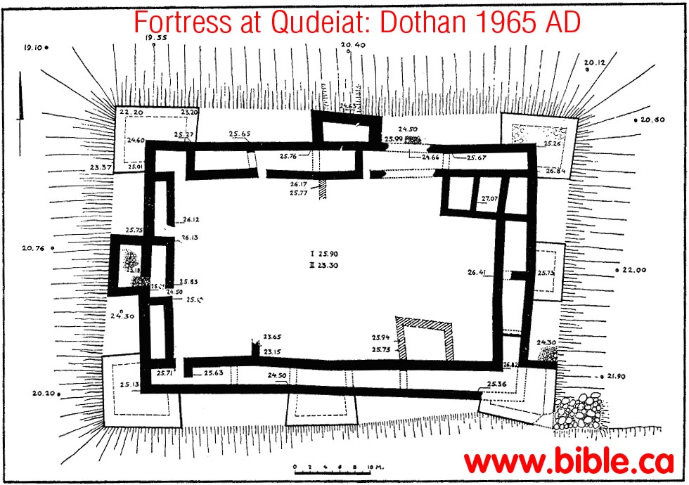
Fig. 1. Plan of the fortress.
The vicinity of the tell is intensively cultivated, and gardens and orchards surround it on all sides. A comparison of the site today with the description in the above survey reveals that in the main the upper walls of the fortress on the tell proper were damaged, many of the stones having completely disappeared.
The main aim of our expedition was to carry out a number of trial soundings on the tell, in order to clarify the exact plan of the fortress, the technique of construction, and the chronology of the site.
To this end the outline of the upper faces of the walls was excavated; near the northeastern tower, excavations were carried down to virgin soil; the interior of the central tower on the western side was examined; several walls and floors were dis-covered within the casemate wall and the fortress; and a part of the glacis on the northern side was laid bare.
THE FORTRESS (Fig. 1)
The fortress of Kadesh-barnea is built in the form of a rectangle, about 60 X 41 m in size. The rampants of the fortress are casemated. They are 4-5 m wide, consisting of two walls, each about one metre thick (Pl. 26, A) and an intervening space. On three sides and presumably on the southern side as well, this space is divided by transverse walls into rooms 4-11 m long. Most of the rooms have metre-wide en-trances leading into the inner courtyard (Pl. 26, B). At each corner of the fortress and halfway down each side there is a square tower, i.e. a total of eight on the perimeter of the fortress. At the bottom of the stratigraphical cut made near the north-eastern tower (Pl. 27, A-B), the start of a wall was found leading south, beyond the confines of the fortress (Pl. 28, A) . In general, the interior of the fotress can be divided into eastern and western sections. The eastern section is higher than the western, and contains traces of walls of rooms especially in the northeastern corner and along the southern casemate rampart. These rooms actually touch the casemate wall. In the western section, and especially at its centre, there is a deep depression, but on the surface there are no visible remains of buildings.
At several spots within the fortress deep soundings were made. From these it became evident that the space between the double walls of the casemate rampart had been filled from the foundations up to floor level, with rubble and mortar. In at least two of the central towers, the same technique of construction was used; however, the corner towers were evidetly built, from the start, in one single block without any framework (with the possible exception of the southeastern tower).
In the northeastern tower several courses were preserved to a height of 5 m.
The foundations of the walls are laid in trenches dug in the wadi-bed or directly on its surface, attaining occasionally a height of 35 cm. The main walls are built mostly of unhewn or crudely dressed stones, laid as headers except at the corners. The walls of the towers are also built of unhewn stones up to a height of about 1.5 m, above which they are built of dressed stones averaging 70 X 40 X 53 cm, in size (Pl. 28, A) .
In the trial-excavation in the central western tower, the floor level of the opening to the casemate was reached. Above this floor, vessels were found intact among the rubble, which was often 1.5 m thick (Pl. 28, B) . Among the debris were pottery and stone vessels, pieces of carbonised beams, and sun-dried bricks measuring 20 X 12 X 15 cm. It is clear that this rubble fell into the room when the ceiling of the upper storey gave way. Thus it seems that the lower part of the rampart was con-structed of stone, filled with rubble and surrounded by a glacis; at least part of the first storey was also built of stone, while the second storey was built of brick
A difficult problem left unsolved by our excavations was the location of the gate. Two possibilities may be suggested, neither of which is completely satisfactory:
a. The gate was located on the northern side of the fortress, at the spot which was breached and evidently destroyed to below the threshhold and to a width of 5 m;
b. The gate was located in the southeastern corner where pavement corresponding to entrance level was found outside the walls.
Concerning the first possibility, it is clear that the threshold should be located at a level higher than the remains of the wall as preserved today. Above the flag-pave-ment a burnt layer, a metre and more thick, was found. However, the slope of the glacis at this spot is too steep to have facilitated access to a gate.
As for the second possibility, it should be noted that though access is quite easy here, the height of the glacis is no more than 2 m above the surrounding area, the opening in the outer wall is so verry narrowabout a metre widethat it resembles a breach or back entrance more than a gate.
One of the more interesting problems at Kadesh-barnea is that of the steep slope on which the walls were presumably erected. Woolley and Lawrence believed that this was merely a talus. However, from the section of the northeastern tower which was excavated down to the foundations, it is apparent that the towers, and evidently also the walls, were built on ground which is only slightly higher than the surrounding area; also the towers often stand on the ancient wadi-bed itself.
A glacis surrounds the fortress on all sides, except the south where the wadi must have formed a bank sufficiently steep for defence. This glacis makes the fortress appear as if it were standing upon a tell; as stated above, the earth bank surrounds the lower part of the wall, which it shields quite well. The glacis is made of terrepise mixed with sun-dried bricks, organic material and gravel. Its surface is formed of large cobblestones (Pl. 29, A). It would seem that the glacis, which had a gradient of 40°, was meant to hinder attackers in ascending the walls, and protect the walls against the erosive forces of floods (Fig. 2) .
Fig. 2. Schematic cross-section through fortress (reconstruction).
The construction of the glacis outside the walls involved the raising of the floors within the casemate rampart, and a difference in levels was thus created between them and the interior of the fortress. There were two ways of overcoming this disparity: 1. to raise the interior of the fortress to the level of the floors within the casemates; 2. to make a gentle slope from the casemates down to the level of the interior. It seems that in the western part of the fortress, at least, the second alter-native was used, as it was simpler and much easier. This is evidently indicated by the depression, possibly a courtyard, still visible today. The eastern part of the in-terior is somewhat elevated, the result of deliberate filling in, or the accumulation of debris from structures built in this part of the fortress.
The few sections that we made enabled us not only to correct and complement the plan of the fortress as described by Woolley and Lawrence, but also to deter-mine the sequence of the settlement on the site, which included three main periods. Period I. On virgin soil, no earlier remains than those of the fortress were found, but in several places, below the level of the base of the main fortress wall, there were remains of a conflagration and sherds. Both at the base of the wall and within the glacis itself, a few sherds were discovered. It may therefore be assumed that there had been a settlement on the site before the construction of the fortress.
Period II. Above these meagre remains the fortress was built. It formed a unit in itself and occupied the entire site. We have no information on any possible changes within the fortress up to the time of its final destruction.
Period III. The trial-trenches within the casemates reveal that the ruined wall was not repaired. The interior of the fortress was used, however, as a dwelling-area, and certain new constructions were built over the rubble of the previous level.
THE FINDS
In accordance with the above division of the site's history, we have divided the finds into three groups:
1. The Pre-Fortress Finds
Most of the finds in this group are sherds of hand-made vessels (Pl. 30, A). The ware is coarse and the clay mixed with straw. The firing is mediocre and the vessels are never slipped. Most of the pottery are deep bowls with flat or thickened rims (Fig. 4 : 1-5) . In addition, hole-mouth jars and store-jars with thick rounded rims, flaring outwards or inwards, were found (Fig. 4 : 6-10) . Some of the bowls and hole-mouth jars had pairs of ledge handles below the rim or high up on the sides (Fig. 4 : 12-17; P1. 30, B); only one loop-handle was found. On one of the hole-mouthed jars a potter's mark appears (Fig. 3 : 11) . Prior to the excavations at Kadesh-barnea, no material of this sort had been reported from other Palestinian sites, with the exception of a vessel discovered in the excavation of Etzion-geber3 and described by Prof. N. Glueck as a 'crucible'. Glueck identified the vessels found at Kadesh-barnea with those unearthed in the lowest level at Etzion-geber. Vessels of this type were later found by Dr. Y. Aharoni during a survey at `Ein Qudeis, and especially at Ramat Matred in the central Negev4. At all these sites, pottery of this type dates from the 10th century or the start of the 9th century B.C.E.
3 BASOR 71, 1938, pp. 3-17; 79, 1940, pp. 2-18; Encyclopaedia Biblica I, Jerusalem, 1950, col. 269 (Hebrew).
4 1E1 10, 1960, Fig. 12 : 1-8.
The Fortress Finds
Phases of building in the fortress were not distinguished and only one floor was found in the casemates. Thus, it may be assumed that these floors had occasionally been cleared of debris. It is therefore not surprising that here the finds are mostly from the last period of the fortress. The pottery dates from the 8th-7th centuries B.C.E. but some comes from the 9th century, including a number of ring-based jugs with a red slip and irregularly burnished on both the base and the body (Pl. 30, C). Also from the 9th century, evidently, is a part of a bowl, with a red-burnished slip bearing traces of a concentric design in black.
Among the group of vessels characteristic of the second half of Iron II (i.e. 8th-7th centuries B.C.E.), there are bowls with disc-bases (Fig. 5 : 5-6; Pl. 30, D) . Burnished bowls of the type in Fig. 5 : 1-2 are common on Judaean sites, though those in Fig. 5 : 3-4 are quite unusual. The type of large basin shown in Fig. 5 : 7 was also found at Megiddo. However, the cooking-pots--mostly of the deep type with two handles (Fig. 5 : 11, 13) and especially the one disployed in Fig. 5 : 12 are evidently earlier than the 7th century. So are the jugs, water decanters and jug-lets (Fig. 5 : 14-17) . Decorated vessels are rare: one, however is ornamented with black and white bands on a red slip, and another with red and black hands on a white background (Fig. 5 : 18; Pl. 30, E). These vessels are similar in their decoration to the 'Moabite' ware collected in Glueck's surveys 5, and to pottery found at Amman6 and Meqabelein7 in Transjordan, dating mainly from the 7th century B.C.E. An-other, relatively common vessel is the hole-mouth jar with thickened or ribbed rim, frequently found on Judaean sites of the 18th-7th centuries B.C.E. (Fig. 5 : 19-23) .
It is the store-jar that was the most common type found on the floors of the case-mates (Fig. 6 : 12, 14) ; Pl. 30, F). Its body is usually sack-shaped, and often without a neck; the shoulder is slightly carinated, the base somewhat pointed, the rim rounded and flaring slightly outward; and the two handles spring from the shoulder to the side. Usually, these vessels are made from medium-fired reddish clay, and they often have a light greenish slip. It is not a usual type in this country; parallels can be found, however, mainly at Tel en-Nasbeh, Lachish and Megiddo 8. At these sites the store-jars in Fig. 6 : 12,13, are similar, though with a higher neck. Several finds of rims and a convex base ( Fig. 6 : 4-10) also belong to store-jars, including hole-mouth, grooved and ridged rim types.
5 AASOR 14, 1934, pp. 14-17, P1. 20.
6 QDAP 11, 1945, p. 71, Nos. 23, 25; p. 74, No. 48.
7 Ibid. 14, 1950, pp. 44-48; P1. XVI, 2-4.
8 R. S. Lamon and G. M. Shipton, Megiddo I, Chicago, 1939, Pl. 13 : 67.
9 0. Tufnell, Lachish HI; The Iron Age, London, 1953, Pls. 83; 149-153.
Also to be noted are the lamps with disc-bases (Fig. 5 : 8-9; Pls. 29, B; 31, A-B 3, or higher bases (Fig. 5 : 10; Pl. 31, A), well-known from levels of the 8th-7th cen-turies B.C.E. at various sites in Judah, such as Lachish9, Tel Beit-Mirsiml°, and Engedi11.
3. The Post-Fortress Finds
The few finds, discovered in several of the buildings within the fortress and in the upper layers of the courtyard, indicate that after the destruction of the fortress, there was only a small settlement on the site. Most of the types of pottery, such as unusual bowls and jars (Fig. 7 : 1-4, 7-11), do not enable an exact dating, though certain others indicate that this settlement flourished in the 5th-4th centuries B.C.E. Among the characteristic pottery of this period are the well-known 'Persian' bowls, with ring-bases and ribbed rims (Fig. 7 : 5-6) ; an Attic lekythos imported in the 5th century B.C.E., known also from various Palestinian and other sites (Fig. 7 : 16-17; P1. 31, C); a lamp with a flat base, continuing the tradition of the Persian period (Fig. 7 : 19); and a tripod bowl, with bracket feet (Fig. 6 : 20).
Special note should be made of a store-jar with high basket handles (Fig. 7 : 1 2 1 3; Pl. 31 D) and a base similar to that in Fig 7 : 14-15. This type, from the 6th-5th centuries B.C.E., is known from such sites as Megiddo12, 'Atlit13, Tel Abu-Hawam14, but especially from Cyprus" and Defenneh in Egypt16. On the shoulder of the vessel we found painted the letter shin and a numeral. The form of the letter is late Assyrian, and is common in Aramaic and Hebrew inscriptions of the Persian period 17. The numeral, similar to an inverted V, is usually considered to designate the value of ten. Recently, Prof. Y. Yadin, in a discussion of the Samaria ostracals, has suggested that it stands for five. If this latter assumption is correct, the inscrip-tion would mean that the jar contained five units of a particular material. The latter shin is most probably an abbreviation of shemenoil, and the indicated unit of measure seems to be a hina liquid measure known from the period of the Return from Babylon 19.
19 AASOR 21-22, 1943, P1. 15 : 5-10. 11 BIES 27, 1-2, 1962, Fig. 23 : 8-9.
12 Lamon and Shipton, op. cit. (above n. 8), Pl. 12 : 63-64.
13 QDAP 2, '1933, p. 51, Fig. 4.
14 Ibid. 3, 1934, Pl. XIII, 12-13.
15 E. Gjerstad, Swedish Cyprus Expedition II, Stockholm, 1935, P1. LXXXVI,1.
16 W. M. F. Petrie, Tanis II, London 1888, P1. XXXIII, 6.
17 `Atiqot 3, 1961, pp. 182ff.
18 Y. Yadin, Ancient Weights and the Date of the Samaria Ostraca, Scripta Hierosolymitana 8, 1961, pp. 19-22.
19 As the hin was equal to 3.6 litres, the jar we found would have held 18 litres of oil. However, it is possible that the capacity of the jar was even larger (and this possibility should not be dis-missed, as it is incomplete and therefore impossible to establish its exact original capacity); and the inscription indicated that it held only five hin, and was not filled to capacity.
20 Lamon and Shipton, op. cit. (above, n. 8), Pl. 78 : 11.
21 C. C. McCown, Tel en-Nasbeh I, Berkeley--New Haven, 1947, P1. 110 : 24.
22 I Kings 22 : 47-48; 2 Chronicles 17 : 12.
23 2 Chronicles 26 : 7, 10.
The other finds of this same period include a fibula (Fig. 3) of a type well known from the end of Iron II and the Persian period (e.g., at Megiddo2° and Tel en-Nasbeh21) , and an iron utensil (a ploughshare? Pl. 31, E) .
CHRONOLOGICAL SUMMARY
Kadesh-barnea was settled even prior to the building of the fortress. At present it is difficult to fix the exact date of the sherds of this early occupation, though they appear to be from about the 10th century B.C.E. There is nothing in the construction of the fortress (which was built later than the 10th century B.C.E.) to indicate its age with certainty. Fortresses with casemate walls were built in Palestine from the 11th century to the 7th century B.C.E. From the ceramic finds, it is clear that this fortress was constructed in the 9th or 8th centuries B.C.E. Historically, this building may be attributed to Jehoshaphat, who reigned in Judah in the years 870-846 B.C.E. This king attempted to enter the Red Sea trade, appointing a governor in Edom and building protective forts along the roads in the South22. In his time, the fortress at Kadesh-barnea would have served as a stronghold protecting the southern border of Judah, and may have been the administrative headquarters for the entire area. However, it is also possible that the fortress was built by Uzziah, who reigned in Judah circa 784-733 B.C.E., and who also fortified the southern limits of Judah, conquered Elath and Edom, and successfully waged war on the Arabs
23.We have no evidence on Kadesh-barnea during the later period of the Judaean monarchy, though it may have played its former important role even under Josiah. The fortress was finally destroyed, apparently by the Edomites, during or at the time of the conquest of Palestine by the Babylonians. The vessels found in situ within the debris of the fortress are from the end of the 7th century B.C.E. and the start of the 6th century B.C.E. In short, it may be said that the available evidence accords with what is known of the expansion of the Kingdom of Judah, and indicates that the fortress was fairly continuously occupied for a period of some 250-300 years.
After the destruction of the fortress, the site was resettled, in the Persian period, towards the end of the 6th century or at the start of the 5th century B.C.E.
We can-not be certain as to how long it was occupied, though its occupancy appears to have ended only in the Hellenistic period. This abandonment of the permanent settle-ment was quite final for, with the exception of a few scattered sherds of the Roman-Byzantine period, there is nothing in the immediate area to indicate a later resettlement. Only the graves on the tell, the Roman-Byzantine settlement on one of the neighbouring hills, and the stone fences in the nearby fields, would indicate that the fortress continued to provide stones for the surrounding inhabitants for hundreds of years to come.
By Steve Rudd: Contact the author for comments, input or corrections.
