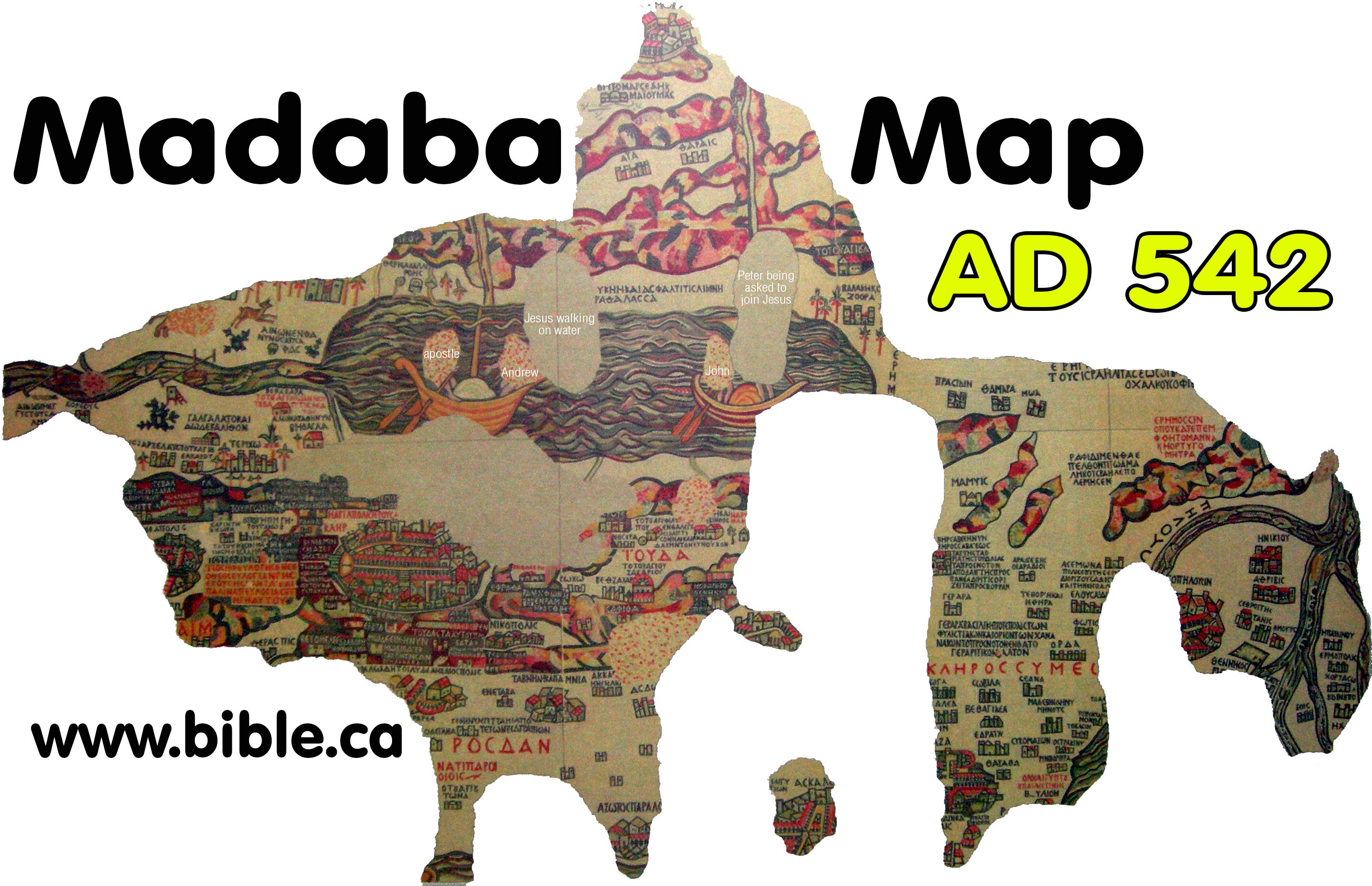
The Madaba Map & the Exodus Route
Dated to AD 542
A mosaic floor at St. George's Orthodox church in Madaba, Jordan
Introduction:
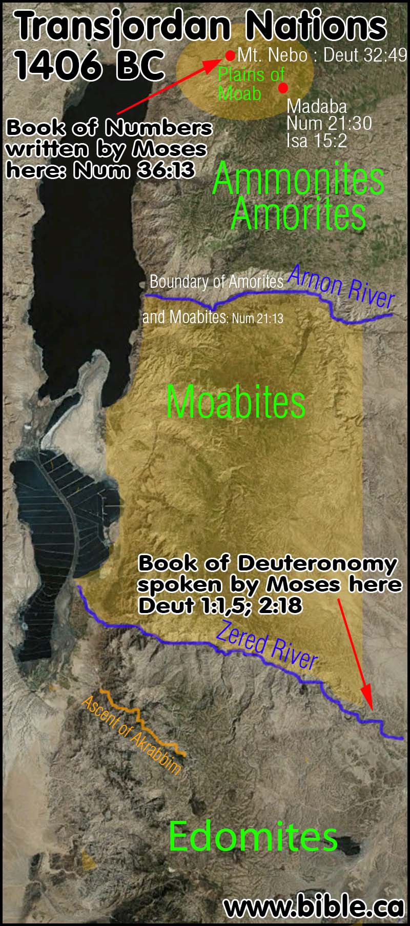
- Historically,
at the time of the Exodus and conquest, 1406 BC, Madaba and Mt. Nebo were
part of the territory of Moab. Isa 15:2; Num 36:1; Deut 32:49.
- In 542 AD,
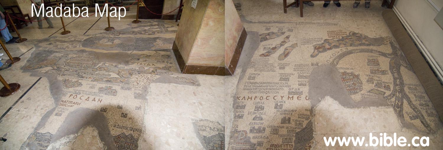
the Madaba Map was finished. It is a large mosaic floor about 20 feet wide
in Madaba, Jordan.
- In 622 AD, the Muslims slit the throats of most of the Christians living from Egypt to Constantinople, including the promised land and the city of Madaba, Jordan. The dark ages of Islam had begun. Christians have been murdered at Muslim hands ever since.
- About 700 AD the Muslims under the Umayyad Dynasty, were offended by the fact that the mosaic portrays Jesus as God's Son and that Jesus is seen walking on water and asking Peter to get out of the fishing boat to join him. So, like their modern Muslim archeological counterparts who excavate the Temple mount with a bull dozer and grind 2000 year old artifacts into gravel for the roads, they defaced the mosaic where it shows Islam to be an apostate religion. (i.e. Jesus is the Son of God) Of course it is odd that this event is portrayed on the Dead Sea where no one fished, especially since the actual story happened in the Sea of Galilee. But this is a devotional map for worship.
- The map is famous because it is one of the oldest maps of Bible lands in the world. The Madaba map, is was clearly based upon the "Onomasticon" written by Eusebius in 325 AD, even though it differs at times from it.
- In 1894 AD,
the Madaba map was rediscovered and is currently under the protection of
the Orthodox church, who rebuilt a church over the mosaic in modern times.
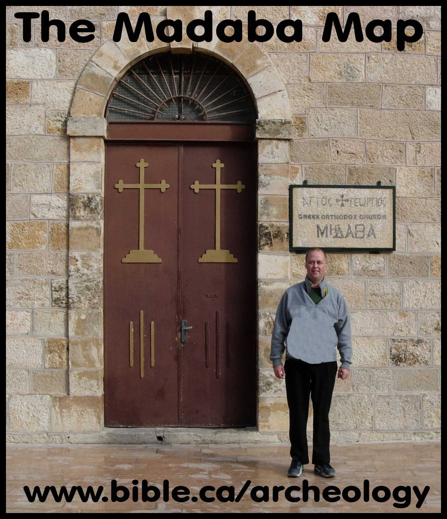
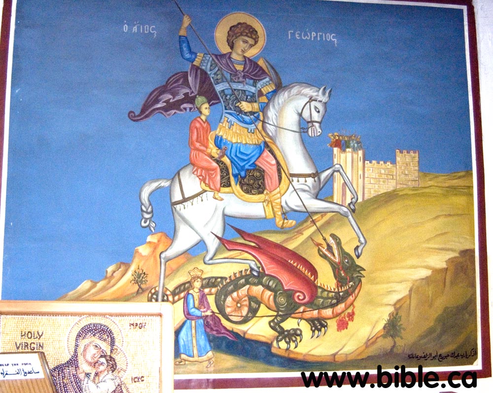
- The map is
currently in St. George's Orthodox church. This is the church that
celebrates the story of St. George slaying a dragon. This photo is of an
500 year old painting in the church of the event. Of course, this gives
evidence of dinosaurs and humans co-existing.
- Ancient church buildings were oriented 180 degrees from the Temple in Jerusalem. The Holy of Holies was entered from the East with the ark of the covenant in the west. Byzantine church buildings were entered from the west with the "altar" in the east. Therefore the Madaba map is oriented so that those sitting in the pews can look ahead to see the map, then look beyond the map and see the pulpit or "Altar". The map is read from the west.
- While modern maps are labeled as if you stand on the south pole and look north. The Madaba map is labeled from the north looking south. This means that the lettering of the map is upside down to how we would orient the map on paper. Its like looking at a map of the USA 180 degrees. (upside down)
- The Madaba map is not to scale. Jerusalem is greatly enlarged and distances are greatly distorted to what we would expect from a the map. But the map was for devotional purposes, not science and geography as we would like it to have been from a modern perspective. When they built the map, one 1/2 inch cube of stone mosaic as a time, they likely never realized they were working on what would be the most important ancient map in existence.
- The Onomasticon says that the city of Medaba is 10 miles west of Kariathaeim: "Kariathaeim. City which "the sons or Ruben" built. There is now a (flourishing) wholly Christian village called Kariatha (Coraiatha), near Mēdaba, city of Arabia, ten miles west toward (the place called) Barē. 582. Kariathaeim. Numbers 32:37; K. 112:14; L. 270:10. Textual variants: Kariathieim (Greek). For contemporary site Coroiath and Eoraiatat (Latin). Another wholly Christian town (cf. K. 26:14) is located west of Madaba and probably indicates Kh el Qureiyat which is near the hot springs of Barē (cf. K. 44:22). Mileage indicates turn off from main Roman highway. Must be distinct from Kariathiareim of Jerusalem (K. 14:23). The Onomasticon and the Exodus route. by Eusebius (325AD)
A. Madaba in the Bible:
- ""But we have cast them down, Heshbon is ruined as far as Dibon, Then we have laid waste even to Nophah, Which reaches to Medeba."" Numbers 21:30
- "from Aroer, which is on the edge of the valley of the Arnon, with the city which is in the middle of the valley, and all the plain of Medeba, as far as Dibon;" Joshua 13:9
- "Their territory was from Aroer, which is on the edge of the valley of the Arnon, with the city which is in the middle of the valley and all the plain by Medeba;" Joshua 13:16
- "So they hired for themselves 32,000 chariots, and the king of Maacah and his people, who came and camped before Medeba. And the sons of Ammon gathered together from their cities and came to battle." 1 Chronicles 19:7
- "They have gone up to the temple and to Dibon, even to the high places to weep. Moab wails over Nebo and Medeba; Everyone's head is bald and every beard is cut off." Isaiah 15:2
B. The exodus route: Border of Egypt
1.
The Wadi el-Arish
is the same as the River of Egypt in Gen 15:18
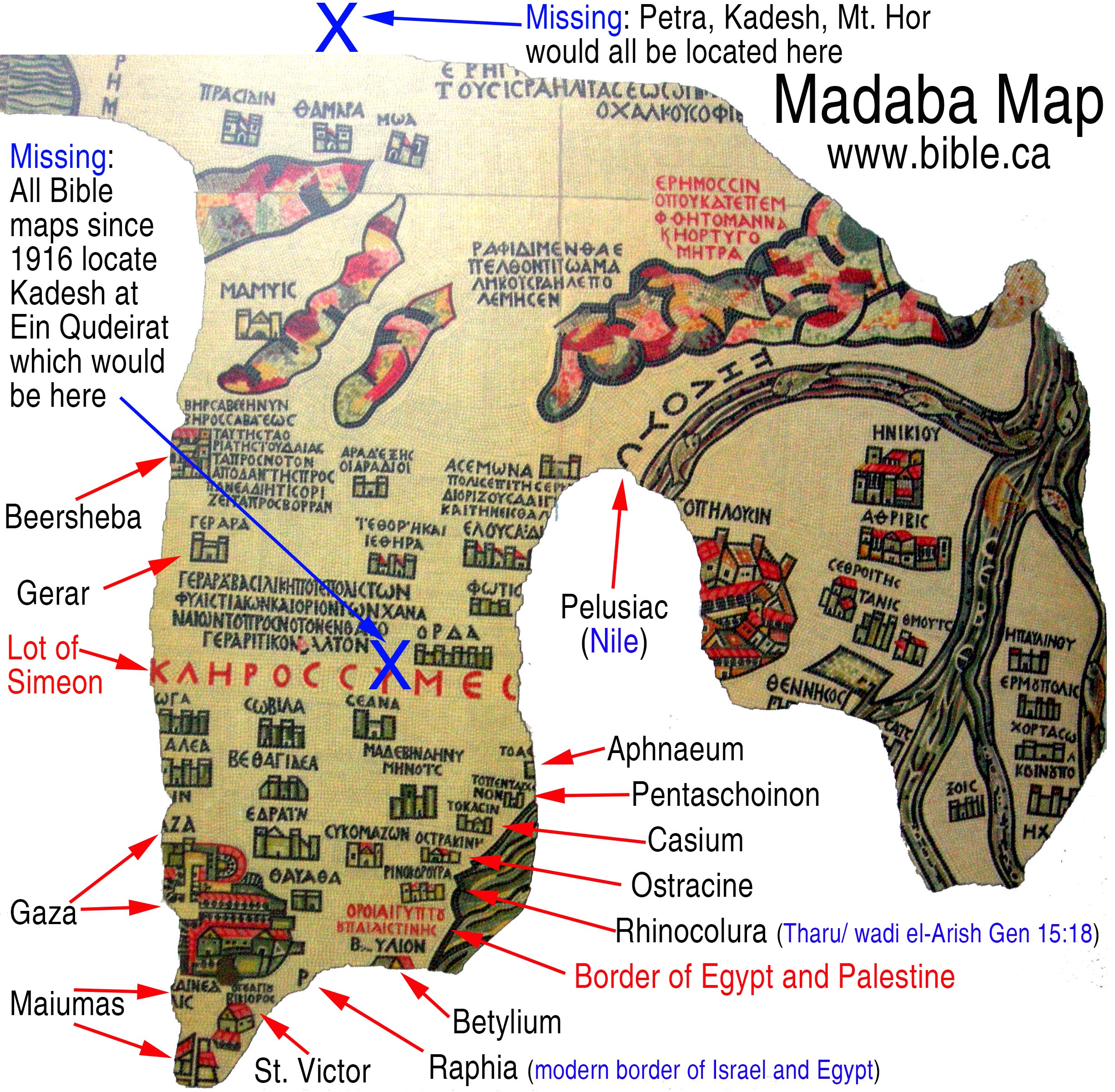
2. All Bible maps have wrongly located Kadesh Barnea at Ein el-Qudeirat since 1916 AD. Yet Qudeirat, if they thought it was important, would have been located on a section of the map that is fully intact. Qudeirat should be located close to the large red text, "lot of Simeon". (see above)
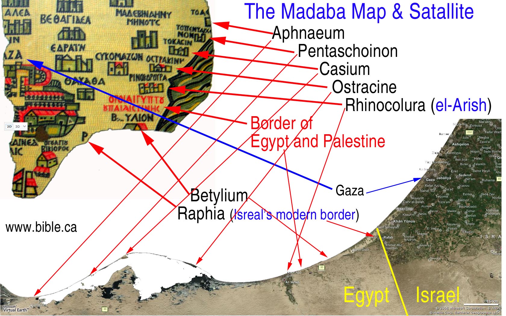
3. The sea port for where the Wadi el-Arish empties into the Mediterranean sea is called el-Arish. The port of Arish is also called Tharu and Rhinocolura. These three names refer to the same place. Rhinocolura gets its name from the fact it was a prison city for criminals of Egypt whom the Pharaoh would literally cut off their noses "Rhino-colura" and force them to live in this sea port on the far edge of Egyptian territory. Arish has been the western border of Egypt since 2000 BC.
4.
Between the towns
of Bitylium and Rhinocolura are the following red words in the Madaba Map:
Border of Egypt and Palestine "Horoi Aigyptou kai Paleaistines".
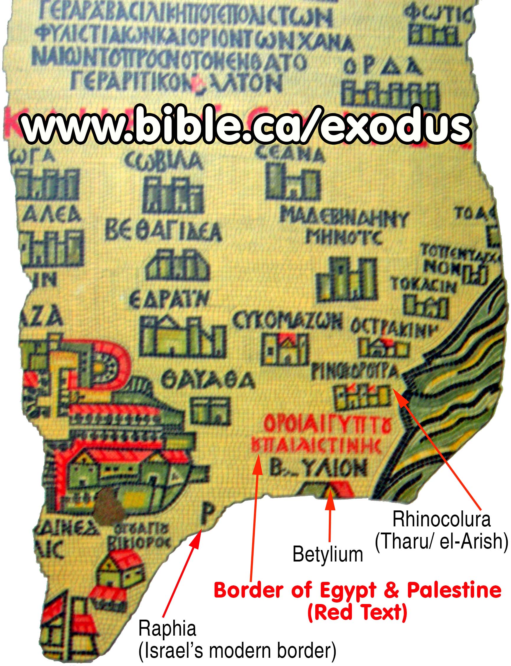
5.
One of the most
important things the Madaba map shows is that the border of Egypt was at the
Wadi al-Arish. This is the historic border between Egypt and Israel from 1446
BC, the time of the exodus , to 70 AD, when Israel was destroyed. In modern
times the border has been moved 44 km north east to Raphia at the eastern edge
of the Gaza Strip. You can see from the Madaba map that the border is between
Bitylium and Rhinoculura (Arish).
6. The Bible clearly shows that the border between Egypt and Israel was just north of the Wadi al-Arish: Genesis 15:18; Joshua 15:4,47. The Wadi al-Arish is the southern/eastern border of the promised land.
7. This proves that the modern Sinai Peninsula was under the control of Egypt and considered Egyptian territory, just as it is today. Since we can prove the Sinai Peninsula was "Egyptian" this proves that Mt. Sinai cannot be where Queen Helena chose it to be in a dream in 325 AD, at Mt. Musa, beside the St. Catherine's monastery. Mt. Sinai was not in Egypt. The Bible says that Mt. Sinai was located in Arabia, not Egypt. (Gal 4:25)
8. The Onomasticon tells us that Bitylium was 20 km south of Raphia. "Bēthphou (Bathaffu). (In) tribe of Juda. A village fourteen miles beyond Raphia on the road to Egypt. It is the border of Palestine." The Onomasticon and the Exodus route. by Eusebius (325AD)
C. The exodus route: Red Sea, Mt. Sinai, Kadesh/Petra
- Missing entirely from the Madaba Map is the Red Sea, Mt. Sinai and Petra/Kadesh Barnea. It would certainly be on the map, but was vandalized by the Muslims in 700 AD. Since we know these locations would be on the map, they must have been the primary targets of defacement. Most notably, however, is that the modern choice for the location of Kadesh Barnea at Ein el-Qudeirat, should be in a section of the map that is fully intact. Qudeirat should be located close to the large red text, "lot of Simeon".
- Petra is
not on the Madaba map and it most certainly would have been. Petra is
where Eusebius located Kadesh Barnea, the Mt. Hor, the rock Moses struck,
the place Miriam died. It would have been located in a section that is
missing. We would expect it to be directly above Praesidium, Thamara, Moa and
above and to the left of "The desert where the Serpent of brass saved
the Israelites".
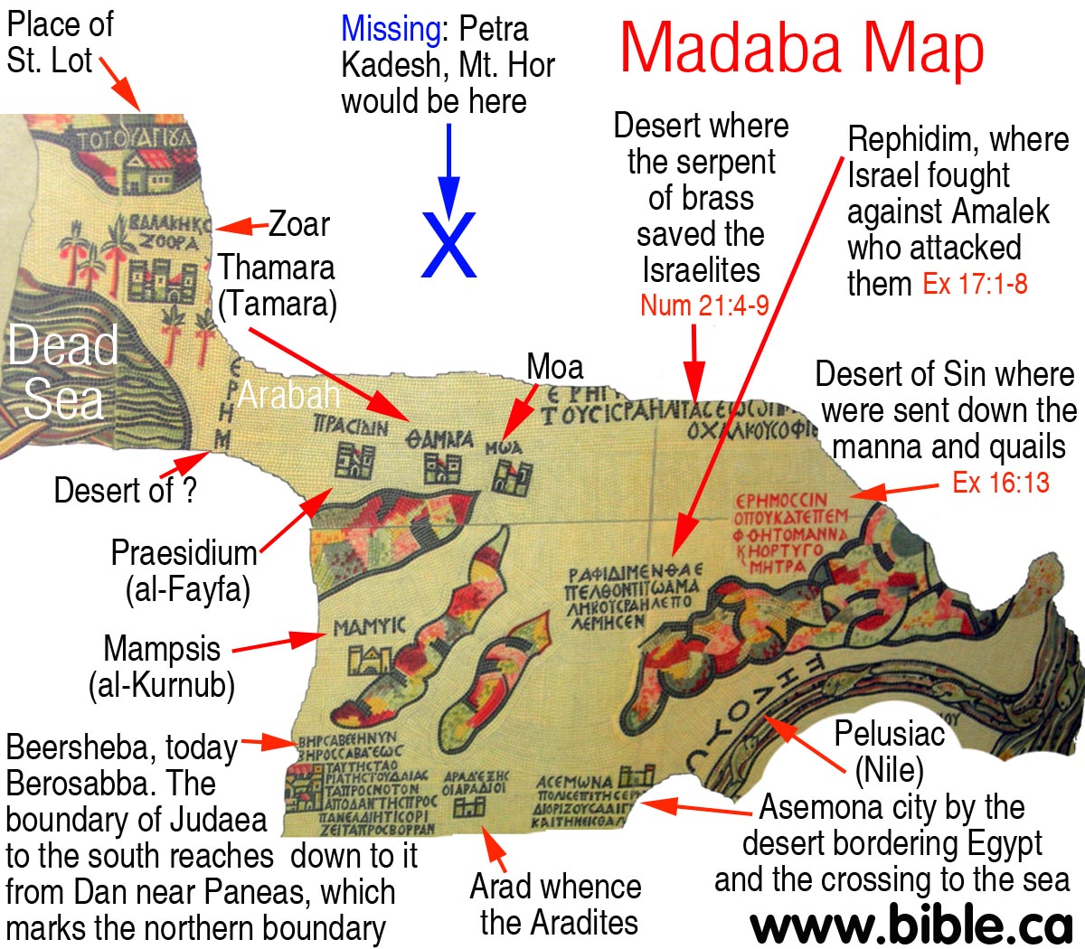
- There is one reference in the Bible to the "Wilderness of Kadesh" and this is also marked on the Madaba Map as the "Desert of", just south of the dead sea: "The voice of the Lord shakes the wilderness; The Lord shakes the wilderness of Kadesh." Psalm 29:8
- Kadesh Barnea, if located at Qudeirat, as most today wrongly believe, should be located on the map in a section that is not damaged. It is not located there. No where on the Madaba map is Kadesh Barnea located. However, if it was, there is absolute certainly that the church from the time of Christ down to 600 AD believed Kadesh Barnea was located at Petra.
- To
complicate matters, it is well documented that geographers from the time
of Herodotus (450 BC) right up to the 17th century AD, had almost no
concept of the Gulf of Aqaba. The Madaba map, in fact, looks exactly like
the map of Herodotus below. Even Strabo
in 15 AD , on the other hand, correctly understood the Gulf of Aqaba.
Compare the map of Herodotus with the Madaba map as they are based upon
the same common misunderstanding of the "V" shaped Red Sea that
branches into the Gulf of Suez and the Gulf of Aqaba.

- It is truly sad that this portion of the Madaba map is missing that shows Mt. Sinai and the shape of the Red Sea.
- We must keep in mind that in 545 AD, the prevailing view of the Western/Latin church (Rome/Roman Catholic) was that Mt. Sinai was located at Mt. Musa in the modern Sinai peninsula. The Madaba Map is located deep into Eastern/Greek (Constantinople/Orthodox) territory of the church. It is entirely possible that there was a rift between east and west as to the real location of Mt. Sinai. Perhaps the Madaba map located Mt. Sinai on the eastern side of the Gulf of Suez. All this is speculation of course. On the other hand, with their misunderstanding of the existence of the Gulf of Aqaba, it may have been mapped the same way on the Madaba map even if it was located in the traditional location west of the Gulf of Aqaba, or where the Bible says it is: in Saudi Arabia (Gal 4:25) on the east side of the Gulf of Aqaba.
- Two little letters "ME" on the top of the Madaba map just right of Zered Wadi, simply cannot be Kadesh Barnea. Both Eusebius and Jerome believed Kadesh was at Petra. Petra was such a major center that many of their references were based upon distances from Petra/Kadesh.
D. The exodus route: Wilderness of Sin and Rephidim
- Some translated maps of the Madaba map show the Wilderness of Sin as the Wilderness of Zin. These are two very different places and wildernesses. The wilderness of Sin is when Israel got the Sabbath revealed for the first time. it is also the place they first got Manna and also quail for food. (Ex 16:13) The wilderness of Zin is north of Kadesh, but includes Kadesh. (Num 27:14) Zin is transjordan and north of Petra in Modern Jordan. Twice during the Exodus God gave Israel quail. First at Sin and second at Kibroth-hattaavah (Num 11:34) and is one stop after Mt. Sinai. (Num 33:16) Therefore the Madaba map says, "Wilderness of Zin: The desert where the Serpent of brass saved the Israelites", it translated incorrectly and should be the Wilderness of Sin. We are certain that the makers of the map knew the difference. Of course if it was the wilderness of Zin, that would directly locate Kadesh Barnea, but then we would not make sense of it because the story of the Manna and quails did not happen there. So it is the wilderness of Sin before Sinai, not Zin at Kadesh.
- Petra is not on the Madaba map. It would have been located in a section that is missing. We would expect it to be directly above Praesidium, Thamara, Moa and above and to the left of "The desert where the Serpent of brass saved the Israelites".(see below).
- The placement of the Wilderness of Sin and Rephidim on the Madaba map is a problem for those who place Mt. Sinai in the mountainous area directly below both. We believe that Mt. Sinai, if it was on the map, would in the missing section at the right of this mountain range.
- Both the "Desert of Sin where were sent down the manna and the quails" (Ex 16:13) AND "Rephidim, where Israel fought against Amalek who attacked them" (Ex 17:1-8) is a problem for those who believe Mt. Sinai is located in the mountain range directly below this text. This mountain range, they believe, represents the modern Sinai mountain range where Mt. Musa is located. The problem is that Israel entered the wilderness of Sin and Rephidim BEFORE they reached Mt. Sinai not after.
- But even if Mt. Sinai was located on the other side of this Mt. range the order is still reversed: The map has them entering Rephidim first, then the wilderness of Sin second, then Mt. Sinai, so even the sequential order is backwards in addition to the major distortions of distance typical of this kind of "devotional map".
- Then we need to figure out how the section of the map that says, "desert where the serpent of brass saved the Israelites" fits into all this. We know that this event happened east of Kadesh/Petra. This means we would expect to find Petra somewhere directly below this text that highlights the events of Num 21:4-9.
- What we do
learn from all this, is that their understanding of the Gulf of Aqaba was
as bad as their understanding of the Bible geography as the scriptures
revealed.
E. The exodus route: Arabah Valley, Zoar, Tamara and Moa
- The words "desert of" are likely a reference to either the Arabah Valley or possibly the "Desert of Cades/Kadesh" frequently referenced by Eusebius in his Onomasticon. The Arabah valley is easy to distinguish on a visual basis, since it would be to the right of the Dead Sea and above the three mountain ranges that Mampsis is located in the middle of. Perhaps Eusebius and the Madaba map were inspired by this verse to located the Desert of Kadesh: "The voice of the Lord shakes the wilderness; The Lord shakes the wilderness of Kadesh." Psalm 29:8
- The fort at Zoar is exactly where we would expect to find it: just above the right end of the Dead sea.
- The series of three forts directly to the right of the Dead sea are known locations. First is Praesidium thought to be at al-Fayfa. Second is Thamara is mentioned in the Onomasticon and is located at Tamara. The third is Moa, perhaps located at near Nahal 'Omer.
- In 1910, Schmidt viewed Kadesh as being at Qedeis and viewed Ein El Weibeh as being the location for Thamara: "Edward Robinson, on his visit to 'Ain el Webeh, June 2, 1838, was so strongly impressed with this most important watering place in the 'Arabah that he identified it with Kadesh Barnea. His description of it was quite accurate. On the assumption that " Mount Seir " and "the land of Edom " had the 'Arabah for its western border, and that all Biblical statements are equally reliable and must at any price be harmonized, he could scarcely reach a different conclusion. When I visited the place in June, 1905, I was particularly impressed with the large number of palm trees and the excellence of the water in one of the springs. The references to Thamara in Ptolemy, the Peutinger Tables, the Notitia, the Onomasticon, the Madeba mosaic, and the recently discovered Beersheba rescript have convinced me that this place is to be looked for at 'Ain el Webeh." (Kadesh Barnea, Nathan Schmidt, 1910 AD)
- Tamara: For a full discussion of Tamara/Thamara, see: Tamar.
- Tamara: Eusebius says in the Onomasticon: "Asasan Thamar (Asasonthamar). Where the Amorrites dwelled whom Chodollagomor destroyed is located near the wilderness of Cades. It is said there is a village Tharmara (a fort Thamara) one day journey from Mapsis on the road from Hebron to Ailam. [Elat on the Red Sea, see Ailam] Today there is a garrison (Roman fort) of soldiers there." Footnote #: 8: Asasan Thamar (Asasonthamar). Genesis 14:7; K. 8:6; L. 234:84. On the Madaba Map there is a Thamara located as suggested by Eusebius here. Tabula Peutinger has a Thamaro 52 or 53 miles from Jerusalem while Ptolemy's list (V, 15, 5f) has a Thamaro about 55 miles distant. The Notitia Dignitatum (74:40) has a Tarba and (74:46) a Thamarra both of which have a garrison. Alt found a fort at Qasr el Juheiniye and he is followed by many locating the fort there and the village at 'ain el 'Arus. Aharoni more recently (TEJ, 1963, p.30ff) suggests 'Ain Husb which is about a day's walk (32 km) from Kurnub which is generally identified with Mapsis (cf. also Avi-Yonah) and has a large Roman fort as well as Nabatean and Iron II sherds. The Madaba Map using Jerome's spelling has located properly Mampsis. Many Nabatean, Roman-Byzantine levels excavated at Kuroub. It shows a revival in the fourth century A.D. as also does Oboda (Avdat, 'Abda, and K. 176:9).This may be indicated by "village" in Greek and "oppidum" in Latin (cf. K. 10:25). II Chronicles 20:2 identified Thamar with En Gedi or at least locates it in the district of En Gedi (86:16). Jerome in Hebrew Questions says, "his city which we now call Engaddi, is rich in balsam and palms since Asason Thamar translated into our language is city of the palms'" (18) (cf. Judges 1: 16, Ezekiel 47: 29).
- Tamar is was identified by Rudolph Cohen to be En Haseva. "In an article last year (BA 57:4119941), we outlined the Roman, Nabatean, and Iron Age remains at (and presented arguments for the identification of the site with the biblical Tamar and the Tamara mentioned in Roman and Byzantine sources. (En Haseva, Rudolph Cohen, The Biblical Archaeologist, Vol. 58, No. 4, Pots & People. (Dec., 1995), pp. 223-235., 1995 AD) This identification of Tamar with En Haseva is quite uncertain. For full discussion see: Tamar
- Moa: Rudolph Cohen says that, Moa unknown to Eusebius, is located at Nahal 'Omer in the central Arabah: "Mo'a (Arabic: Kh. Maiyat 'Awad) is situated near Nahal 'Omer in the central 'Arabah (map ref. 1654 9947). It was first surveyed in 1933 by F. Frank. He distinguished the exact ground plan of the principal building, which he described as a Roman castellum, and noted additional structures on hills to the east and west. He proposed the identification of the site with Asuada, referred to in the Notitia Dignitatum (early fourth century C.E.). Abel and Avi-Yonah proposed the identification of Maiyat 'Awad with Mo'a, which appears on the Madaba map... Mo'a was clearly an important way-station on the road from Petra to Gaza, and consisted of a number of building units. Agricultural terraces were surveyed over a wide area in its neighborhood. The finds indicate that it was founded in the third-second centuries B.C.E., reached its zenith during the reign of Aretas IV, and continued to exist even after the Roman annexation of the Nabatean kingdom in 106 C.E., until the end of the third century. In recent years the site has been surveyed by numerous scholars. In 1980, in the framework of the Negev Emergency Survey, Mo'a was examined by a team directed by D. Nahlieli. ... Mo'a was clearly an important way-station on the road from Petra to Gaza, and consisted of a number of building units. Agricultural terraces were surveyed over a wide area in its neighbourhood. The finds indicate that it was founded in the third-second centuries B.C.E., reached its zenith during the reign of Aretas IV, and continued to exist even after the Roman annexation of the Nabatean kingdom in 106 C.E., until the end of the third century." (Rudolph Cohen, Notes and News, Israel Exploration Journal 32, 1982 AD, p164-165)
E. The exodus route: Shechem (Nabulus) Mt. Gerizim and Mt. Ebal.
- The Madaba
map places the two mountains twice, in two different locations: On the
Madaba map, the mountains of Ebal and Gerizim are in two different
locations. One is at Shechem (Modern Nabulus) and one near Jericho and
Gilgal. This is because the Orthodox Jews had created a new location near
Jericho in their longstanding dispute with the Samaritans. Eusebius,
Jerome and the creators of the Madaba map were fully aware of the two
traditions and chose to represent both on the map.
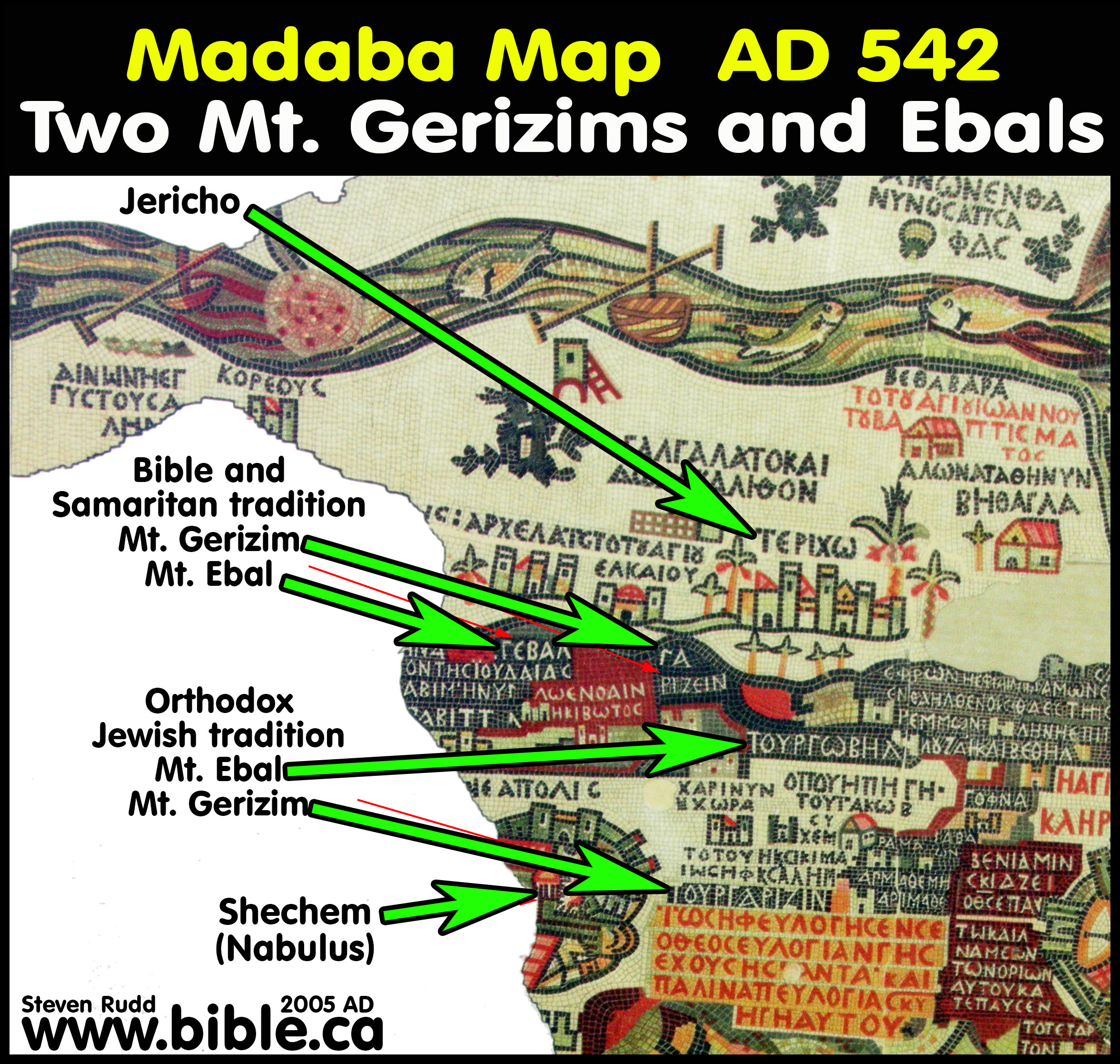
- In 325 AD,
Eusebius believed that the Samaritan's choice for Mt. Gerizim was wrong
and said so in his Onomasticon
which he wrote in 325 AD. He likely based this on the Bible verse that
said it was opposite Gilgal: "Are they [Mt. Ebal and Gerizim] not
across the Jordan, west of the way toward the sunset, in the land of the
Canaanites who live in the Arabah, opposite Gilgal,
beside the oaks of Moreh?" Deuteronomy 11:30
From the Onomasticon of 325 AD:
Mt. Ebal: "Gaibal (Gebal). Mountain in the Promised Land where Moses commanded an altar to be built (at the command of Moses an alter was built). They say (there are) two neighboring mountains facing each other located at (near) Jericho, one of which (is said) to be Garizin [Gerizim], the other Gaibal [Ebal]. But the Samaritans erroneously point out two others near Neapolis (argue for two mountains near Neapolis but they err greatly) since the great distance of one from the other there shows that they are not able to hear one another when calling out from one (hear the voices calling out in turn blessing or cursing as Scripture records)." (Eusebius, Onomasticon 325 AD)
Mt. Gerizim: "Garizein (Garizin). Mountain where those calling out the blessing (curse) stood. Read the above mentioned Gaibal (Gebal)." (Eusebius, Onomasticon 325 AD)
Gilgal: "Golgol or Galgal. The Scriptures teach this is near Mt. Garisein and Mt.Gaibal. The place of Galgal is in the Jericho region (near Jericho). [Therefore the Samaritans err who would point out Mt.Gairsin and Mt.Gebal near Neapolis which Scripture testifies are near Galgal.]" (Eusebius, Onomasticon 325 AD)
Footnote from Onomasticon : This and the following entry can be treated together. The Onomasticon begins by recording the simple biblical information here. The generally accepted tradition is to follow the Samaritan tradition as given here. The two mountains are on either side of Neapolis (K. 4:28) and are Jebel es-Slamiyeh and Jebel et Tur. The Madaba Map reflects this tradition by having them near Shechem (K. 150:1) called Garizin and Gōbel. The pilgrims also recognize this identity. "At Neapolis is Mt Gazaren where the Samaritans say Abraham brought the sacrifice. And to ascend up to the summit are 300 steps. At the foot of the mountain is located a place by the name of Shechem" (Itin. Bourd. PPT I, 18). Zeno and Justinian built churches on Garizein according to Procopius Buildings V, vii, 5-17. Excavation of this area is going on. But Eusebius and Jerome prefer to follow an anti-Samaritan location. The Madaba map hesitates between the two opinions and so locates Gebal Garizeini near Ierichō [Jericho] (K. 104:25). The use of the LXX names in Ierichō region and the Aramaic in the Neapolis area may signify some preference. Since Josephus and the later Byzantines had the correct tradition, this rabbinic tradition must have developed in the late first and early second centuries. Procopius 905C is also confused: "This is situated at the Eastern part of Ierichō beyond Galgal" and he continues by denying the Samaritan tradition. Yet in 908A he seems to accept the Samaritan location and tradition. The two mountains near Jericho are probably those above Aqaba jabr sometimes called Tyros and Thrax. The Roman road to Jerusalem passed between them. In Interpretation of Hebrew Names "Gebal, ancient abyss or stone building" (87). (Eusebius, Onomasticon 325 AD) - Herbert Donner comments on this: "The mountains Gerizim and Ebal are represented twice on the Madaba Map: near Jericho and near Neapolis. What has happened here? The problem can be solved on the basis of Eus. On. 64:9-14 where, strangely enough, both mountains are indeed located near Jericho. Eusebius, however, does not fail to add: "The Samaritans show other ones near Neapolis, but they are wrong, for the mountains shown by them are too far from each other, so that it is impossible to hear one´s voice when calling to each other." Although this seems to be entirely intelligible and is confirmed by Deut. 27, the Samaritans were by no means wrong. Eusebius was wrong, and everybody knew it, perhaps he himself included. The Samaritans laid claim to the mountains, considering them to be their own holy mountains. Hostility to the Samaritans forced the orthodox Jews in Jerusalem to locate both mountains at another spot, for the Samaritans were not allowed to be right. Eusebius followed the orthodox Jewish tradition. The mosaicist, however, being well informed, preferred a Solomonic solution: he listed the mountains twice, indicating by larger letters that he regarded the location near Nablus as being correct." (Herbert Donner, The Mosaic Map of Madaba, Kampen 1992, 24.48)
- Here is a detailed study of the Samaritans and why they chose Mt. Gerizim as "their Jerusalem".
By Steve Rudd: Contact the author for comments, input or corrections.
