Petra, Jordan (Kadesh Barnea)
|
|
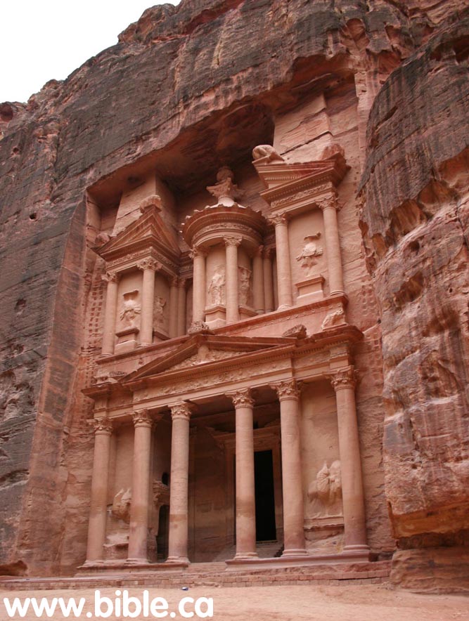
1. Josephus, Eusebius and Jerome all said that Kadesh Barnea was located at Petra. The Treasury at Petra was carved by the Nabataeans in 100 BC and represents a reuse of the Hebrew city. 2. This unusual "city of the tombs" carved into solid sandstone by the Nabataeans was the place Israel buried their dead for 38 years. 3. Since the time of Joshua, is has been called "The Rock" (Sela/Petra) because this is where Moses brought water out of the Rock. |
Introduction: Reasons why Petra is Kadesh:
See also the main page on Kadesh Barnea
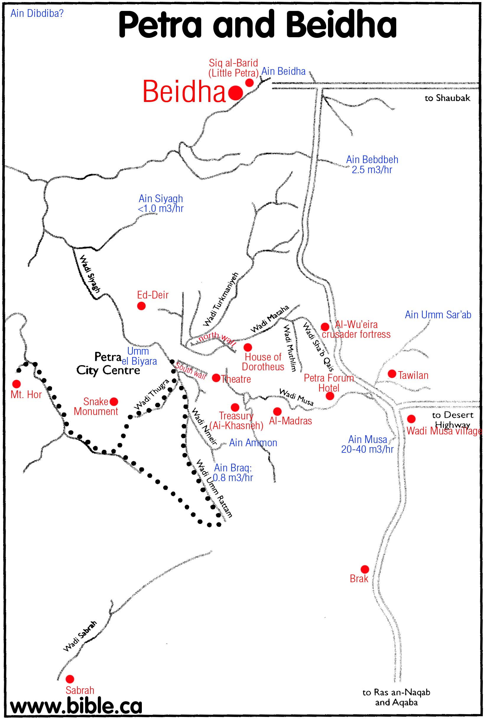
1. It is our conclusion that Kadesh Barnea is located Transjordan at Petra between El Beidha and Basta.
a.
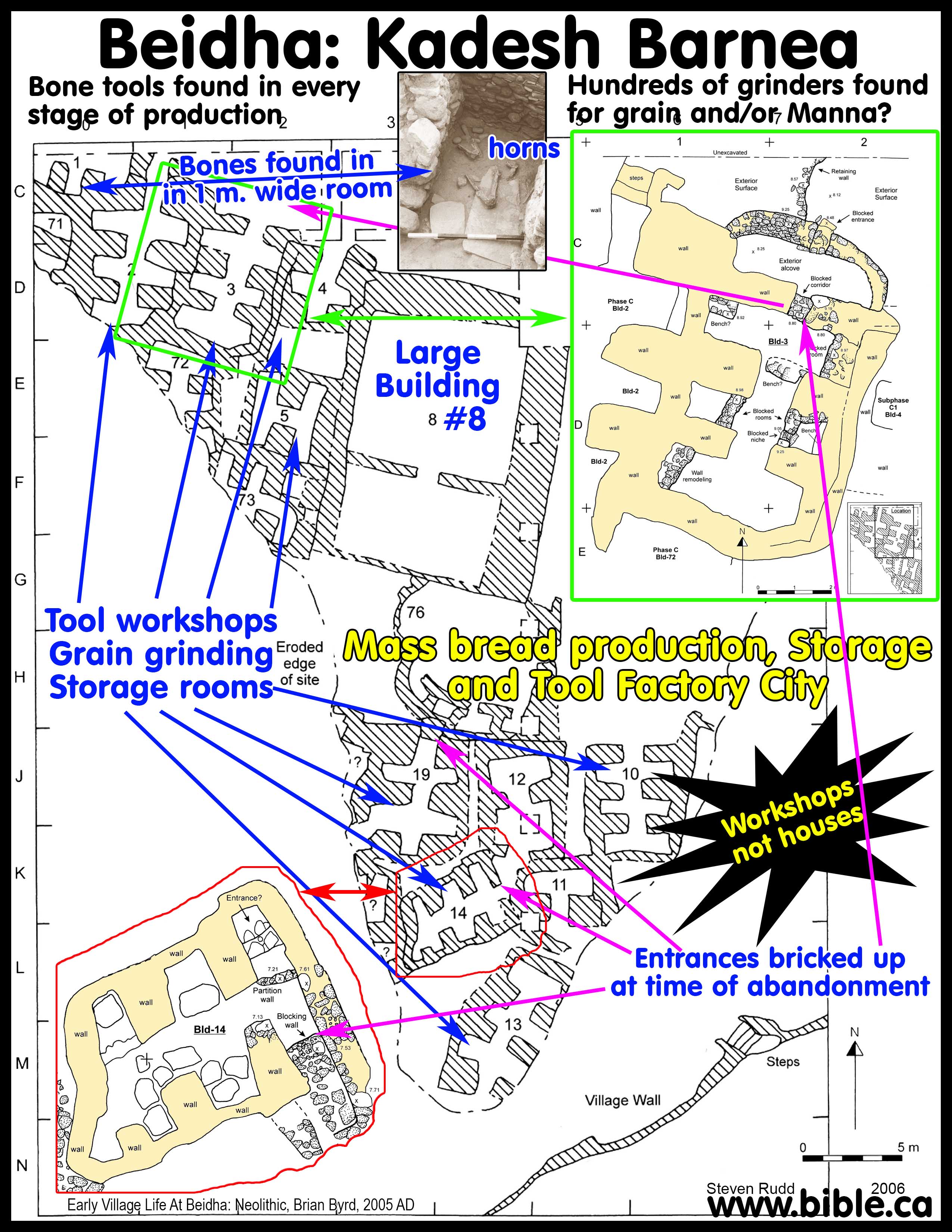
El
Beidha (5 km north of Petra) was a commercial tool manufacturing and mass
food production center. There were no residential dwellings in the final
occupation Phase C which was built by Moses in 1444 BC then abandoned 38 years
later in 1406 BC.
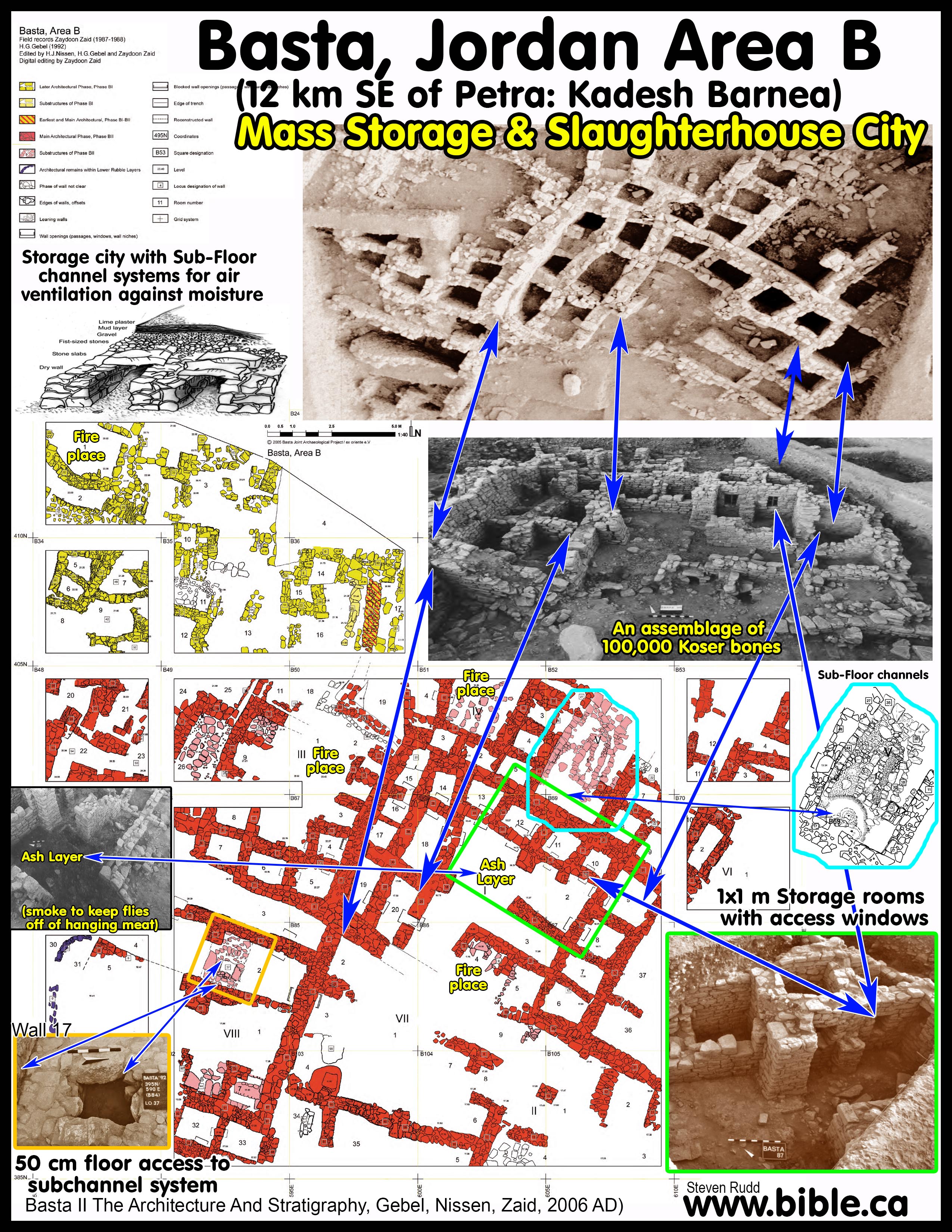
b.
Basta
(12 km SE of Petra) was a mass production meat packing plant and crop storage
center. An massive assemblage of 100,000 kosher bones were excavated on the
production floors. Like Beidha, Basta was built by Moses then abandoned.
2. The Bible places Kadesh Barnea at Petra:
a. You can prove from the Bible that Kadesh must be Transjordan, east of the Arabah Valley. (see below or southern boundaries of Judah for more specific details.)
b. When Israel departed Kadesh, they headed south towards the Red Sea and came to Mt. Hor where Aaron died. We know, therefore, that Kadesh is either at Petra, or just north of it.
3. Ancient Literary sources place Kadesh Barnea at Petra:
a. Eusebius (325 AD), Jerome (400 AD) both said that Kadesh was located at Petra. They also said that in their day, they could still see the rock that Moses struck with his staff for water.
b. Josephus (110 AD), Eusebius (325 AD), Jerome (400 AD) all stated that Petra is where Aaron died on Mt. Hor. Mt. Hor was Transjordan outside the promise land only one stop from Kadesh.
4. All Bible maps since 1916 AD wrongly locate Kadesh Barnea at ein el-Qudeirat which is 27 km inside formal stated boundary of the promised land. Israel did not spend 38 years in the wilderness in the territory given to Judah. So the current choice of Kadesh at Qudeirat is wrong for three reasons:
a. Scripture explicitly places Kadesh Barnea Transjordan, yet Qudeirat is cisjordan.
b. Scripture explicitly says Kadesh Barnea is outside the promised land, yet Qudeirat is 27 km inside Judea and Simeon territory.
c. Scripture explicitly says that Kadesh Barnea was on the border with Edom, yet Edom first moved west of the southern Arabah valley between Elat and the Salt Sea after 605 BC at the first invasion of Nebuchadnezzar.
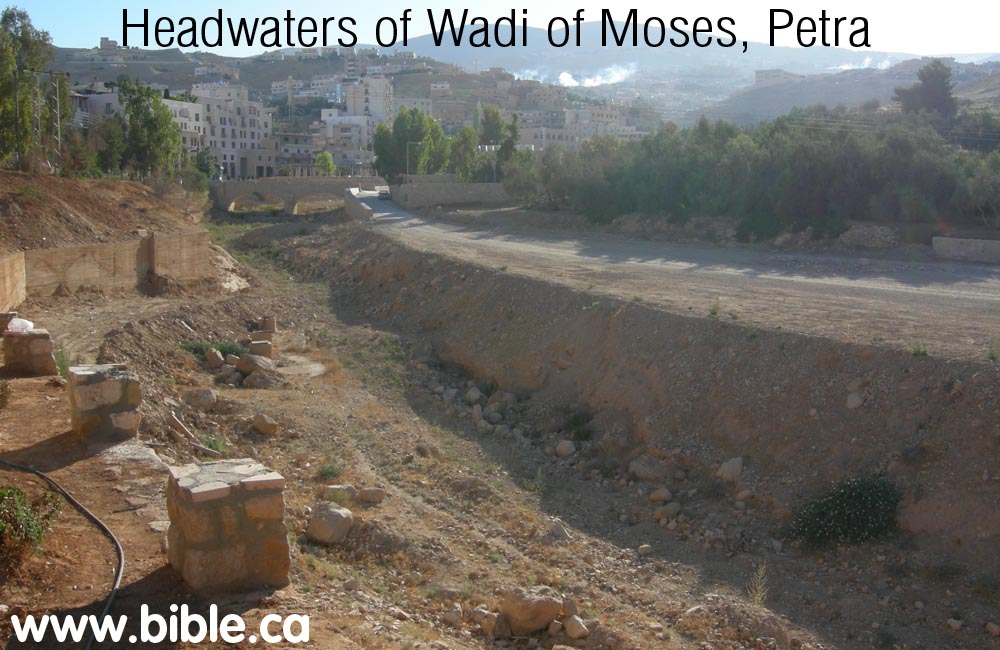
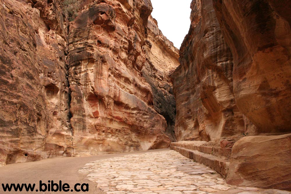
5. The name "Petra" means rock, because this is the place where Moses "brought water out of the rock". The Bible refers to Petra three times as "Sela", which also means rock. In 325 AD Eusebius said that he could visit Petra and see the very rock that Moses split in two and water came out. We believe that the 1 km long crevice called "the Siq", is itself what was split in two. People are looking for a single rock that split, when in fact it was more like an earth quake that split an entire mountain in two. More on the rock that split.
6. There is an ancient tradition (Eusebius) of the "River of Moses" (Wadi Musa) that flows through the 1 km long crevice (Siq), past the Nabataean Treasury then down into the Arabah valley. This reinforces why it is called, "Petra". Both the Rock that Moses struck and the resulting flow of water are ancient traditions at Petra. There are several springs in the Petra area even today. The Siq is a complex geological feature that has many places where water could enter it.
7. Geologist, Dr. Don Patton has personally examined the "River of Moses" (Siq), and has concluded that the canyon has hydrological features consistent with water cutting. As you walk the Siq, there are many fissures where water came out of the rock and joined the main flow. The Roman road that was recently excavated 15 feet below the current surface level which, proves that the Siq is a dead relic canyon that has not deepened in 2300 years. This indicates that a large continuous flow of water cut the canyon quickly.
8. Archeology has uncovered evidence an occupation of Petra of from the Early Bronze Age (Abraham: 2100 BC), Iron Age (David, Solomon, 1000 BC), Nabataeans (350 BC - 106 AD) and the Romans (106 AD - 300 AD).
9. Archeologists look for candidate locations of Kadesh with large natural water supplies.
a. "Despite 75 years of excavation, only one percent of the city has been investigated." (How Petra was Built, Shaher M. Rababeh, 2005, p28)
b. Ein el-Qudeirat, for example, was chosen for just this reason. Today Qudeirat is the almost universal choice of location on all Bible maps because it is the largest spring in the Sinai Peninsula for a 100 km radius. But the real Kadesh was described as a waterless place with no crops, grazing lands or fruit trees.
c. Only with a miracle of Moses hitting the rock, did a large river result. Although we can prove from Tell el-kheleifeh, that sea levels are unchanged, the water table levels have dropped dramatically since the Exodus.
d. Even during the time of Christ there were many springs flowing at Petra. In 15 AD, Strabo: "The metropolis of the Nabataeans is Petra ... and the inside parts having springs in abundance, both for domestic purposes and for watering gardens. (Strabo. Geography 16:4:21, 15 AD) Yet today, the 5 springs of Petra, have almost all dried up. So Kadesh is likely located at a place with no springs at all that we can see today!
10. No one knows why the tombs of the dead are there. It even says this in the official site information.
a. Perhaps it is because it is near Mt. Hor where Aaron and Miriam were buried.
b. Since they spent 38 years at Kadesh, the tombs were where the dead Israelites were kept.
c. The Nabateans found the site continued in the tradition started by the Hebrews of using it as a burial city. "The city underwent major construction in the period 50 BC to AD 100 during the reigns of Obodas II (III) and Aretas IV (with construction of the Treasury, Q'asr al Bint, Temple of the Winged Lions and Theatre), and Roman and Greek technologies most probably influenced the water-system design." (The Water Supply of Petra, Charles R. Ortloff, Cambridge Archaeological Journal, 2005, 15:1:93-109)
11. The location of Petra was unknown in 1600 AD.
a. It was rediscovered in 1812, by John Lewis Burckhardt.
b. Maps from the 1600's knew of its existence but they were not sure where to locate it. For example, in 1587 AD, Abraham Ortelius had two locations for Petra and Kadesh Barnea. A precedent for mapping uncertain locations in two places is also found in the Madaba map regarding the location of Mt. Gerizim and Mt. Ebal. Just as the Madaba Map has two locations for Gerizim and Ebal, so too does Abraham Ortelius's map have two locations for Petra and Kadesh Barnea.
c. What is clear, however, is that Abraham Ortelius located Kadesh Barnea beside Petra. He just didn't know where Petra was! See our map page for more details.
12. After a careful research of the Bible and history and archeology, it is evident that Kadesh Barnea was located in the general Petra area.
a. The population of 3.5 million Hebrew enhabited a 20 km territory range from ancient El Beidha located 5 km north of Petra, to Basta located 12 km SE of Petra.
A. Petra in the Bible:
- "The border of the Amorites ran from the ascent of Akrabbim, from Sela (Petra) and upward." Judges 1:36
- "He killed of Edom in the Valley of Salt 10,000 and took Sela (Petra) by war, and named it Joktheel to this day. " 2 Kings 14:7
- "Send the tribute lamb to the ruler of the land, From Sela (Petra) by way of the wilderness to the mountain of the daughter of Zion. " Isaiah 16:1
- "Let the wilderness and its cities lift up their voices, The settlements where Kedar inhabits. Let the inhabitants of Sela sing aloud, Let them shout for joy from the tops of the mountains." Isaiah 42:11
- Speaking of the Exodus: "But I would feed you with the finest of the wheat, And with honey from the rock I would satisfy you." Psalm 81:16
B. Jesus: "The Rock of Salvation" in the Bible:
1. The theological significance of God bringing water from the rock at Kadesh and Sinai cannot be overlooked.
a. The first reference to God being the "Rock" after Moses struck the rock, is: "The Rock! His work is perfect, For all His ways are just; A God of faithfulness and without injustice, Righteous and upright is He." Deuteronomy 32:4.
b. The last reference is: "and all drank the same spiritual drink, for they were drinking from a spiritual rock which followed them; and the rock was Christ." 1 Corinthians 10:4
2. The imagery of Christ as "The Rock", as well as all the varied "rock" imagery throughout the Bible, has its origin in Moses at Sinai and Kadesh.
a. Moses striking the rock lays the foundation of a major Bible anti-type applied directly to Christ as the Rock that provides food and water for salvation, safety, security and judgement.
b. Detailed study about the water Moses provided by miracle at Sinai and Kadesh.
C. The Bible explicitly teaches that Kadesh is Transjordan:
1. It can be clearly determined that Kadesh lie Transjordan, east of the southern Arabah valley. This is accomplished by simply reading the two main Bible passages (Num 34:3-5; Josh 15:1-4) that draw the southern boundaries of Judah.
2.
In these verses, Kadesh Barnea is a reference point. It says that the
border "goes up south of Kadesh". Since Kadesh cannot be inside the
promised land, it must be Transjordan. ein
el-Qudeirat is where all Bible maps have mistakenly placed Kadesh since
1916 AD, but this puts Kadesh 27 KM inside the promised land. This blatant
contradiction should bother Bible students.
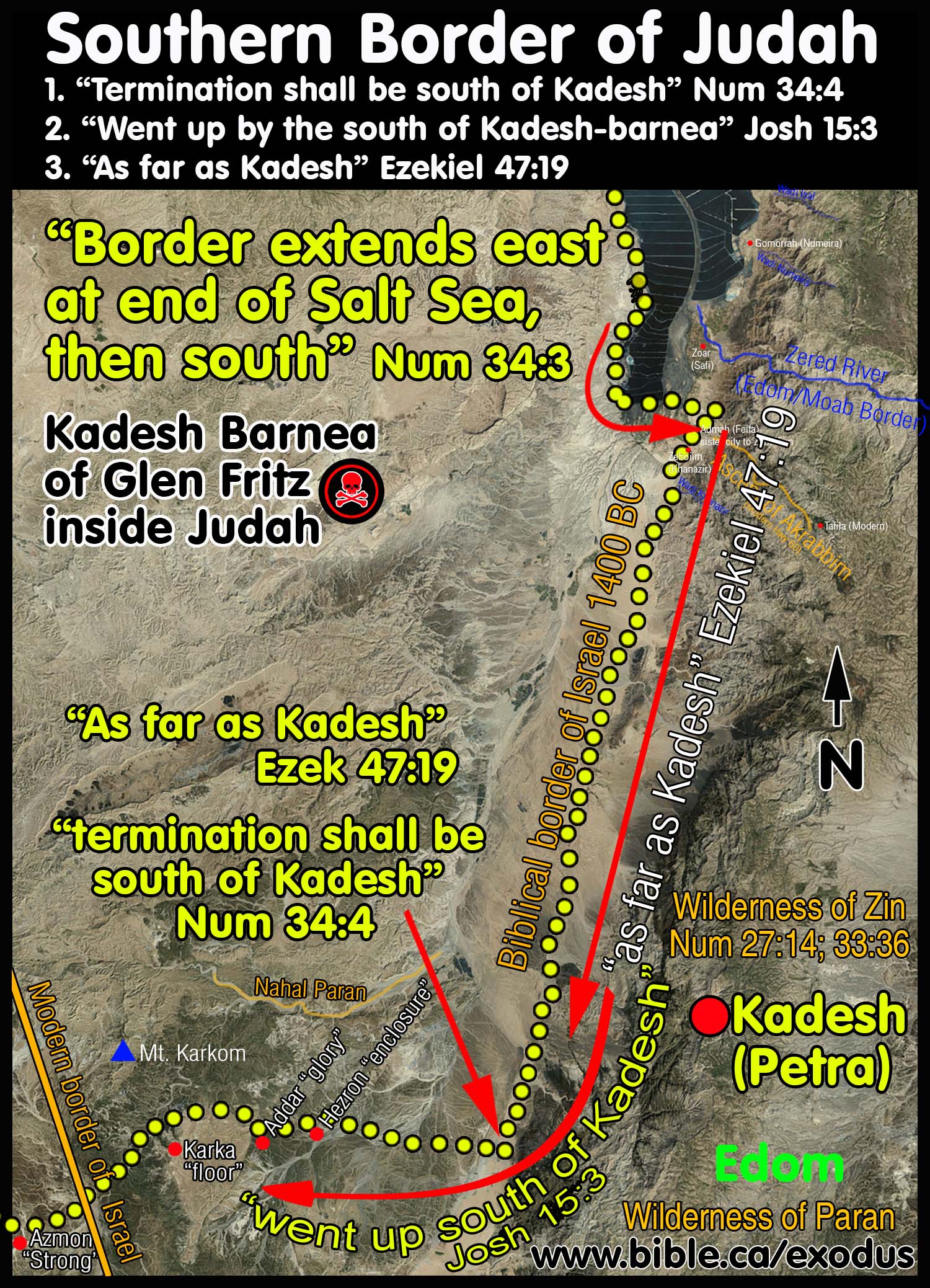
3. Imagine you are in a car driving on the Bible border of Judah. You start driving at Engedi and follow the western shoreline of the Dead Sea.
a. When you reach the end of the Dead Sea, turn left (East) and start driving towards modern Jordan. Those who wrongly place Kadesh at ein el-Qudeirat must head WESTWARD, not Eastward. They go 180 degrees the wrong direction and head in a straight line through the assent of Akrabbim (wrongly located at Ma'ale Aqrabim on the west side of the Arabah valley), and continue in a straight line through the middle of Judah's territory (which they call the Wilderness of Zin) and then to complete their comedy of errors, on to ein el-Qudeirat as their choice for Kadesh. But if you drive eastward, as the Bible says, you reach the real "assent of Akrabbim", turn right and drive due south towards the Gulf of Aqaba. Next you pass the Wilderness of Zin on your left (in modern Jordan), but you never actually enter the Wilderness of Zin.
b. Then, as you keep driving due south, you pass Kadesh Barnea (at Petra) on your left. THIS IS THE ONLY WAY KADESH REMAINS OUTSIDE THE BOUNDARY OF THE PROMISED LAND as the Bible says. After you pass the sign on the road that says, "Kadesh due East on your left" you keep driving SOUTH OF KADESH.
c. A few miles south of Kadesh is where the north/south portion of the border "terminates". The border continues "as far as Kadesh" then changes direction due west, and starts heading for the Brook of Egypt. So as you drive past Kadesh on your left, only then do you make a 90 degree turn to the right and start driving due west towards the River of Egypt. In this way the border "went up south of Kadesh". Placing Kadesh Barnea at ein el-Qudeirat simply cannot harmonize any of these details.
d. Only when Kadesh is located somewhere Transjordan between the Dead Sea and the Red Sea on the eastern side of the Arabah valley, do these details fit perfectly!
4. "On the assumption that "Mount Seir" and "the land of Edom" had the 'Arabah for its western border, and that all Biblical statements are equally reliable and must at any price be harmonized, he could scarcely reach a different conclusion [that Kadesh is at Petra]." (Kadesh Barnea, Journal of Biblical Literature, Nathan Schmidt, Vol 29, no 1, 1910 AD, p68)
D. History of civilizations living at Petra:
- Time of Abraham 2100 BC: "En-mishpat" Gen 14:7. Kadesh was known at the "Spring of Judgement" (En-mishpat). Notice that that the writer of Genesis (perhaps Moses) adds the parenthetical thought: "(that is, Kadesh)". This means that it was not called Kadesh in the time of Abraham. Two additional references to Kadesh at the time of Abraham are: Genesis 16:14; 20:1. The writer probably just substitutes for the Hebrews at Moses' time, Kadesh in the place of En-mishpat. There are other examples in Genesis of places that were called names that did not exist when the story is being told. The word "Jordan" in Genesis 13:10, refers to the Jordan river and valley. Yet this river was not called Jordan until after the time of Joshua. We can prove this because the word Jordan literally means: "down from Dan" or that which flows downhill from the territory of the tribe of Dan. "its name Jord (i.e. Yored, flowing down from), Dan (Bechoroth, fol. 55a); or יאור דן the "stream of Dan" (Rabbi Joseph Schwarz, 1850). Obviously if the modern name of the Jordan river owes its origin to the tribe of Dan, it was not called this before they actually began to occupy the land under Joshua in 1406 BC. Yet Genesis applies this name, first used in 1406 BC to events that took place in 2000 BC. The same is true with applying the name "Kadesh" to time of Abraham, even though it was really called, En-mishpat in Abraham's day and Abraham never heard the place called Kadesh.
- The Edomites moved into the Petra area after centuries after the Hebrews abandoned the city.
- Kadesh Barnea was renamed Sela "rock": "But
it is almost certain that of the two, "sela," like our word
" cliff," is the grander and more abrupt feature ; which is of
importance as excluding from the claimants to the name of Kadesh, such
spots as 'Ein El-Weibeh, where the rocks are merely stony shelves of three
or four feet in height. But the name "Sela" is also the same as
that by which in later times the place now called " Petra" was
designated. As the southern boundary of Judah is described as reaching
over the " ascent of scorpions " to Kadesh, so the Amorite
boundary is described as "from the ascent of scorpions, from `the
cliff' (sela), and .upwards." [Joshua xv. 3 ; Judg. i. 36.]
"Amaziah took `the cliff' (sela) by war." " Other ten
thousand did the children of Judah carry away captive, and brought them up
to the top of `the cliff' (sela), and cast them down from the top of I the
cliff' (sela), that they were all broken into pieces." [2 Kings xiv.
7 ; 2 Chron. xxv. 12. The use of this word in these passages makes it
probable that the denunciation of Psalm exxxvii. 9, is aimed not against
the "daughter of Babylon," but against "the children of
Edom."-"Happy shall he be that rewardeth thee as thou bast
served us ; happy shall he be that taketh and dasheth thy little ones
against the `cliff' (sela)."] The name of
Kadesh almost entirely disappears from the Sacred Books before the name of
Sela appears, and it is therefore possible that the latter, taken
from its natural peculiarity, may have been given to it by the Edomites or
later settlers, after the recollections of its earlier sanctity had passed
away. That a sanctuary of this kind should have been gradually transformed
into an emporium and thoroughfare of commerce, as was the case with Petra
during the Roman empire, would be one out of many instances with which
oriental and ancient history abounds." (Sinai
and Palestine, in connection with their history, Arthur Penrhyn
Stanley, 1856 AD, p84-99)
That the Qenites were at home in Edom is indicated by Balaam's punning proverb with regard to them in Numbers 24:21: "Everlasting is thy habitation and set in the Rock [ Sela] is thy nest [Qen] ". The pun on Qen and Qenite is obvious, and Sela is to be identified with Umm el-Biyarah in Petra. (The Civilization of the Edomites, Nelson Glueck, 1947 AD) - Amaziah (796 - 767 BC) renamed Kadesh Barnea, Joktheel:
"the blessedness of God": "For about a century, Judah was
unable to push forward again into Edom, which during this period evidently
worked the mines in the Wadi Arabah. Edom, however, was not long to enjoy
its independence. Amaziah of Judah waged successful war against it,
capturing Sela, whose name he changed to Joktheel
(2 Kings 14:7; 2 Chronicles 25:11-12)." (The
Civilization of the Edomites, Nelson Glueck, 1947 AD)
"A generation later, in the reign of Amaziah of Judah (c.800-783 BCE), the people of Petra took a battering once again. Amaziah "led out his people and went to the Valley of Salt, and smote 10,000 men of Seir [Petra]". Then followed a horrific act of barbarity against prisoners of war: "The men of Judah captured another 10,000 alive, and took them to the top of the rock and threw them down from the top, and they were all dashed to pieces." (2 Chron. 25:5-13). Scholars argue about the numbers but nobody can argue that it was not an atrocity. However, the king underwent an amazing conversion: "After he came from the slaughter of the men of Seir, he brought their gods and set them up as his own gods, and worshipped them, making offerings to them." (v. 14)." (Petra A traveler's Guide, Rolalyn Maqsood, 1994 AD, p13-73, p125-129, p159) - Nabataeans (350 BC - 106 AD) renamed Petra "rock" "The city underwent major construction in the period 50 BC to AD 100 during the reigns of Obodas II (III) and Aretas IV (with construction of the Treasury, Q'asr al Bint, Temple of the Winged Lions and Theatre), and Roman and Greek technologies most probably influenced the water-system design." (The Water Supply of Petra, Charles R. Ortloff, Cambridge Archaeological Journal, 2005, 15:1:93-109)
- Romans (106 - 300 AD) "It is traditional to look for Roman technical advances that improved the Nabataean system, but few are found. This indicates that Roman engineers may have viewed the Nabataean system as near-optimum. In that case, it is likely that the several water-management techniques observed by the Romans may have been borrowed by them and applied to their desert cities and outposts." (The Water Supply of Petra, Charles R. Ortloff, Cambridge Archaeological Journal, 2005, 15:1:93-109)
- "Some 150 scrolls discovered when the church was excavated in 1993 —reveal a vibrant community well into the seventh century A.D., after which the church and, apparently; most of the city was finally abandoned. (Reconstructing Petra, Smithsonian: June 2007; Vol 38, Num 3, Andrew Lawler )
- Rediscovered in 1812 AD by John Lewis Burckhardt: "The Anglo-Swiss geographer and traveler John Lewis Burckhardt 'rediscovered' Petra on 22 August 1812, and recognized its ruins as those of the ancient Nabataean capital city." (Petra: a guide to the capital of the Nabataeans, Rami G. Khouri, 1986, p11-27, p41-44)
Part II: Sources who affirm Kadesh is at Petra:
It is moreover one of the few facts localised by anything like an authentic tradition,-in this case preserved by Josephus, the Talmudists, Eusebius, and Jerome, --that Kadesh was either identical, or closely connected with Petra. (Sinai and Palestine, in connection with their history, Arthur Penrhyn Stanley, 1856 AD, p84-99)
A. 110 AD: Josephus: Aaron died on Mt. Hor at Petra:
- 110 AD: Josephus stated that the burial place of Aaron was at Petra.
- "Then it was that Miriam, the sister of Moses, came to her end, having completed her fortieth year since she left Egypt, on the first day of the lunar month Xanthicus. They then made a public funeral for her, at a great expense. She was buried upon a certain mountain, which they call Sin; and when they had mourned for her thirty days ... Now when this purification, which their leader made upon the mourning for his sister, as it has been now described, was over, he caused the army to remove and to march through the wilderness and through Arabia; and when he came to a place which the Arabians esteem their metropolis, which was formerly called Arce, but has now the name of Petra, at this place, which was encompassed with high mountains, Aaron went up one of them in the sight of the whole army, Moses having before told him that he was to die, for this place was over against them." (Josephus, Antiquities 4.82-83)
B. 325 AD: Eusebius: Kadesh and Mt. Hor are at Petra:
- In 325 AD Eusebius (and Jerome in 400 AD) wrote the Onomasticon, which is a "dictionary of places".
- The Onomasticon says that in their day, you could still see the rock Moses struck at Kadesh and the tomb of Aaron were at Petra.
- At Petra, the 1 km long Siq that the water was channeled down is called, the "wadi of Moses" according to ancient tradition.
- Eusebius writes: "Kadesh Barnea (or Cades Barnea): "Kadea Barne. The desert which extends to (the city of) Petra a city of Arabia. There Mariam went up and died, and there the doubting Moses struck the rock to give water to the thirsty people. The tomb of Mariam herself is pointed out there even now. There also Chodollagomor beat the chiefs of the Amalakites." (Eusebius, Onomasticon, round brackets are Eusebius') Footnote #: 580. Kadēa Barnē. Numbers 32:8; K. 112:8; L. 270:4. Textual variant city of Palestinē (Greek) instead of Arabia. This reflects again the uncertainty of editorial additions and of the use of Arabia in the Onomasticon (K. 110:27). Latin combines K. 112:7 and K. 112:8. Some confusion in order of this and the next three entries. A summary of biblical information from Numbers 21:1, 11; Numbers 27:14 and Genesis 14:7. A tomb tradition is here. No location is given other than near Petra (K. 142:7). Procopius repeats the entry in 332D and 1021D. It also is reaffirmed by Jerome in Commentary on Ezekiel 38:23(cf. K. 46:26). In Interpretation of Hebrew Names "Cades, holy or change" (63); "Cades, alteration or holy" (80); "Cadesbarne, selected change or changeableness" (80). (The Onomasticon, Eusebius, 325AD)
- Eusebius writes: "Mt Hor: ōr. Mountain on which Aaron died near the city of Petra. There is now pointed out the rock which flowed for Moses (which Moses struck and gave water to the people)." Footnote #: 979. ōr. Numbers 20:22, 28; K. 176:7; L. 291:88. Mt. near Petra (K. 142:7). Cf. K. 126:19 and K. 46:14 for Aaron's death. See K. 150:23 for Mt. Seir. Josephus Antiquities IV, 4, 7 tells of Aaron's death up on the mountain range that encloses Petra. In Interpretation of Hebrew Names "Or, passionate" (77) and "Or, light" (83). (The Onomasticon, Eusebius, 325AD)
- Eusebius writes: "Kadēs. Where the spring "of judgment" was. Footnote #: 579. Kadēs. Genesis 14:7; K. 112:7; L. 269:3. Simple biblical notation. In Hebrew Questions Jerome says "Cades is a place near Petra called the spring of judgment where God judged the people". (The Onomasticon, Eusebius, 325AD)
- Eusebius writes: "Bēroth. "Of the sons of Jakeim (Iacim)." Place in the desert where Aaron died. It is pointed out (still today) ten miles from Petra on the summit of the mountain." (The Onomasticon, Eusebius, 325AD)
- Eusebius writes: "Beroth. "Of the sons of Jakeim (Iacim)." Place in the desert where Aaron died. It is pointed out (still today) ten miles from Petra on the summit of the mountain." (The Onomasticon, Eusebius, 325AD)
- Eusebius writes: "Barnea (same as Kadesh Barnea): "Barne: This is Cades Barne, on the desert which extends up to the city of Petra." (Eusebius, Onomasticon, round brackets are Eusebius') Footnote #: 213. Barnē. Joshua 10:41; K. 46:26; L. 247:74. Identified with the desert stretching south of Petra (K. 142:7) and more frequently Kadēs Barnē (K. 112:8). (The Onomasticon, Eusebius, 325AD)
- Eusebius writes: "Petra. City in the land of Edom in Arabia which is called Iechthoel. This is also called Rekem by the Assyrians (Syrians). Footnote #: 762. Petra. Judges 1:36; K. 142:7; L. 279:71. No letter division in the Vatican Greek manuscript here. Procopius 1048B has Petra in Idumala (K. 102:23). On Tabula Peutinger it is 48 miles south of Theman (K. 96:18). It is an important reference for the Onomasticon and all the Roman road systems. It is also called Rekem (K. 144:7 and K. 36:13). Mt. Hor (K. 176:7) is nearby. The Nabatean influence lasted into the Roman period of the Onomasticon. Petra was one of the Nabatean cities given autonomy about 106 A.D. with the establishment of the Roman Province of Arabia. It was a great city in the 3rd and 4th centuries. The Christians of Petra were persecuted by Diocletian. (The Onomasticon, Eusebius, 325AD)
- Eusebius writes: "Rekem. It is also Petra, city of Arabia, "whose ruler Rocom the children of Israel killed. It is said he was also king of Madiam." Footnote #: 773. Rekem. Numbers 31:8; K. 144:7; L. 280:94. Identity and summary of biblical information (Joshua 13:21; Numbers 31:8; cf. K. 142:7 and K.36:13, for Petra, named Rekim by Josephus). In Interpretation of Hebrew Names "Recem, variety or painting". (The Onomasticon, Eusebius, 325AD)
- Notice that Eusebius sees two different Cades, but the true Cades (or Kadesh Barnea) is next to the wilderness of Paran, also known as the desert of the Saracens: "Gerara. The Geraritike is now called after this, (the region) beyond the Daroma. Twenty-five miles south of Eleutheropolis. It is the old southern boundary of the Chanaanites and a royal city of the Philistines (metropolis of Palestine). It is located, as Scripture affirms, "between Cades and Sur" (i.e., between) two deserts. The one adjoins Egypt whence the people came having come through the (straits of the) Red Sea. The other (true) Cades extends up to the desert of the Saracens." (The Onomasticon, Eusebius, 325AD) Of course the Bible does not say that Gerar is between Kadesh Barnea and Shur, but that Abraham lived there, then moved and sojourned near Gerar. Eusebius and the Madaba map correctly place Gerar, but confuse its position in relation to Kadesh and Shur. Even today people misread Gen 20:2 the same way Eusebius did.
- Eusebius writes: "Asasan Thamar (Asasonthamar). Where the Amorrites dwelled whom Chodollagomor destroyed is located near the wilderness of Cades. It is said there is a village Tharmara (a fort Thamara) one day journey from Mapsis on the road from Hebron to Ailam. [Elat on the Red Sea, see Ailam] Today there is a garrison (Roman fort) of soldiers there." Footnote #: 8: Asasan Thamar (Asasonthamar). Genesis 14:7; K. 8:6; L. 234:84. On the Madaba Map there is a Thamara located as suggested by Eusebius here. Tabula Peutinger has a Thamaro 52 or 53 miles from Jerusalem while Ptolemy's list (V, 15, 5f) has a Thamaro about 55 miles distant. The Notitia Dignitatum (74:40) has a Tarba and (74:46) a Thamarra both of which have a garrison. Alt found a fort at Qasr el Juheiniye and he is followed by many locating the fort there and the village at 'ain el 'Arus. Aharoni more recently (TEJ, 1963, p.30ff) suggests 'Ain Husb which is about a day's walk (32 km) from Kurnub which is generally identified with Mapsis (cf. also Avi-Yonah) and has a large Roman fort as well as Nabatean and Iron II sherds. The Madaba Map using Jerome's spelling has located properly Mampsis. Many Nabatean, Roman-Byzantine levels excavated at Kuroub. It shows a revival in the fourth century A.D. as also does Oboda (Avdat, 'Abda, and K. 176:9).This may be indicated by "village" in Greek and "oppidum" in Latin (cf. K. 10:25). II Chronicles 20:2 identified Thamar with En Gedi or at least locates it in the district of En Gedi (86:16). Jerome in Hebrew Questions says, "his city which we now call Engaddi, is rich in balsam and palms since Asason Thamar translated into our language is city of the palms'" (18) (cf. Judges 1: 16, Ezekiel 47: 29). (The Onomasticon, Eusebius, 325AD)
- Eusebius writes: "Ailam (Ailath). Is situated at the extremity of Palestine between the southern desert and the Red Sea where cargo was transported by ship from both Egypt and India. A detachment of the Tenth Roman Legion is stationed there. Properly called Aila today (it was formerly pronounced Ailath) from whence the ancient people the Ailamites whose king was Chodollagomor [who is mentioned in the Acts of the Apostles]. Another Ailam of the foreigners (of Palestine) is noted in Kings." Footnote #: 6: Ailam (Ailath). Genesis 14:1; K.6:17; L. 234:75. In the Vulgate we find Ailath, Elath, and Aila for this same site. Palestine is the southern part of Syria. This word is missing in the Vatican Manuscript. Technically the southern limits of the Onomasticon should be Ailam (Ailath). The ruins are inland about one mile from Aqabah but not as far inland as Tell el Kbeleifah which is probably the older Ezion Geber (K. 36:l, cf. K. 34:23, 62:13, Josephus Antiquities, IX, 12, 1). It was the end of the road going north to Damascus and the terminus of the overland road west to the Mediterranean. In Jerome's time it was a very busy port (Vita Hilariaris, 18, and cf. Commentary on Ezekiel 47:18). Eusebius does not indicate its size but it may be inferred that it was a polis. A bishop was present at Nicea. Eusebius uses some army source and the text is useful for noting the deployment of the Roman legion. The Tenth is located here. The Notitia Dignitatum (73:18f.) verifies this entry. The Tabula Peutinger, 820 has a Haila 83 miles from Petra and 150 miles southeast of Gaza which fits this site at el 'aqaba. The city in II Samuel 10:16 is in northeast Transjordan. The Syriac text notes it is a city of the Philistines. The Greek allophulos usually means Philistines but once or twice we cannot be positive, so in this present translation the general term "foreigners" has been preferred, especially when Jerome does not have Filistine. He has Filistine in K. 7:15, K. 21:2, K. 3:25, K. 119:3 but more often uses transliteration allofylorum (see Appendix I). (The Onomasticon, Eusebius, 325AD)
- The Onomasticon references two "Kades": One near Gerar and but the "true Cades" at Petra. Eusebius places Arad near the Desert of Kadesh Barnea, but the Madaba map places Arad between Beersheba and Egypt rather than between Beersheba and the Dead sea. However the Madaba map is not to scale and has huge distortions of distance and relative size. "Arad. City of the Amorrites near the desert of Cades. There is now (shown) a village four miles from Malaatha, and twenty from Hebron. Tribe of Juda." (The Onomasticon, Eusebius, 325AD)
C. 400 AD: Jerome: En-mishpat, Kadesh, Spring of Judgement is at Petra: Gen 14:7
- "Gen 14:7: And they returned and came to the fountain of judgement, that is, to Cades. Because Cades was so named later on, it is specificied by way of anticipation; and it refers to a place near Petra, which is called 'The Fountain of Judgement', because God judged the people there" (Saint Jerome's Hebrew Questions on Genesis, translated by C. T. R. Hayward, p 46, Gen 14:7, 1995 AD)
- "Kadēs. Where the spring "of judgment" was. Footnote #: 579. Kadēs. Genesis 14:7; K. 112:7; L. 269:3. Simple biblical notation. In Hebrew Questions Jerome says "Cades is a place near Petra called the spring of judgment where God judged the people". (The Onomasticon, Eusebius, 325AD)
- "No location [for Kadesh Barnea] is given other than near Petra (K. 142:7). Procopius repeats the entry in 332D and 1021D. It also is reaffirmed by Jerome in Commentary on Ezekiel 38:23(cf. K. 46:26). In Interpretation of Hebrew Names "Cades, holy or change" (63); "Cades, alteration or holy" (80); "Cadesbarne, selected change or changeableness" (80). (The Onomasticon, Eusebius, 325AD)
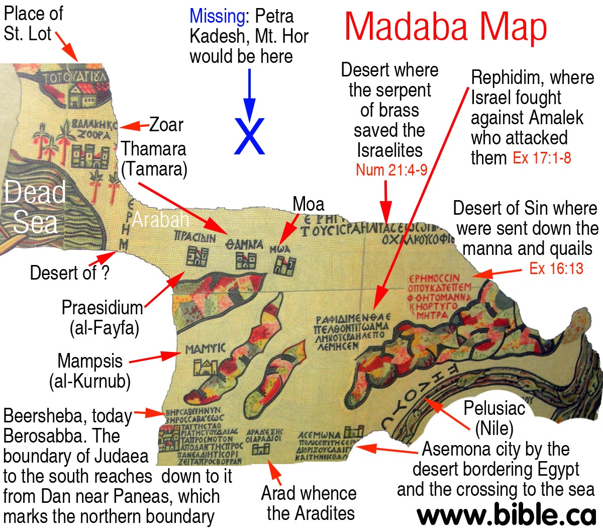
D. 542 AD: The Madaba Map:
- In 542 AD, the Madaba Map was based upon Eusebius's Onomascticon and Jerome. It is not what is on the Madaba map, but what is missing that proves Kadesh Barnea is not where all Bible maps locate it today. The Madaba does not have Ein el-Qudeirat, (the modern choice of Kadesh) located in a section of the map that remains.
- All Bible maps have wrongly located Kadesh Barnea at Ein
el-Qudeirat since 1916 AD. Yet Qudeirat, if they thought it was
important, would have been located on a section of the map that is fully
intact. Qudeirat should be located close to the large red text, "lot
of Simeon". Most notably, however, is that the modern choice for the
location of Kadesh Barnea at Ein
el-Qudeirat, should be in a section of the map that is fully intact.
Qudeirat should be located close to the large red text, "lot of
Simeon".
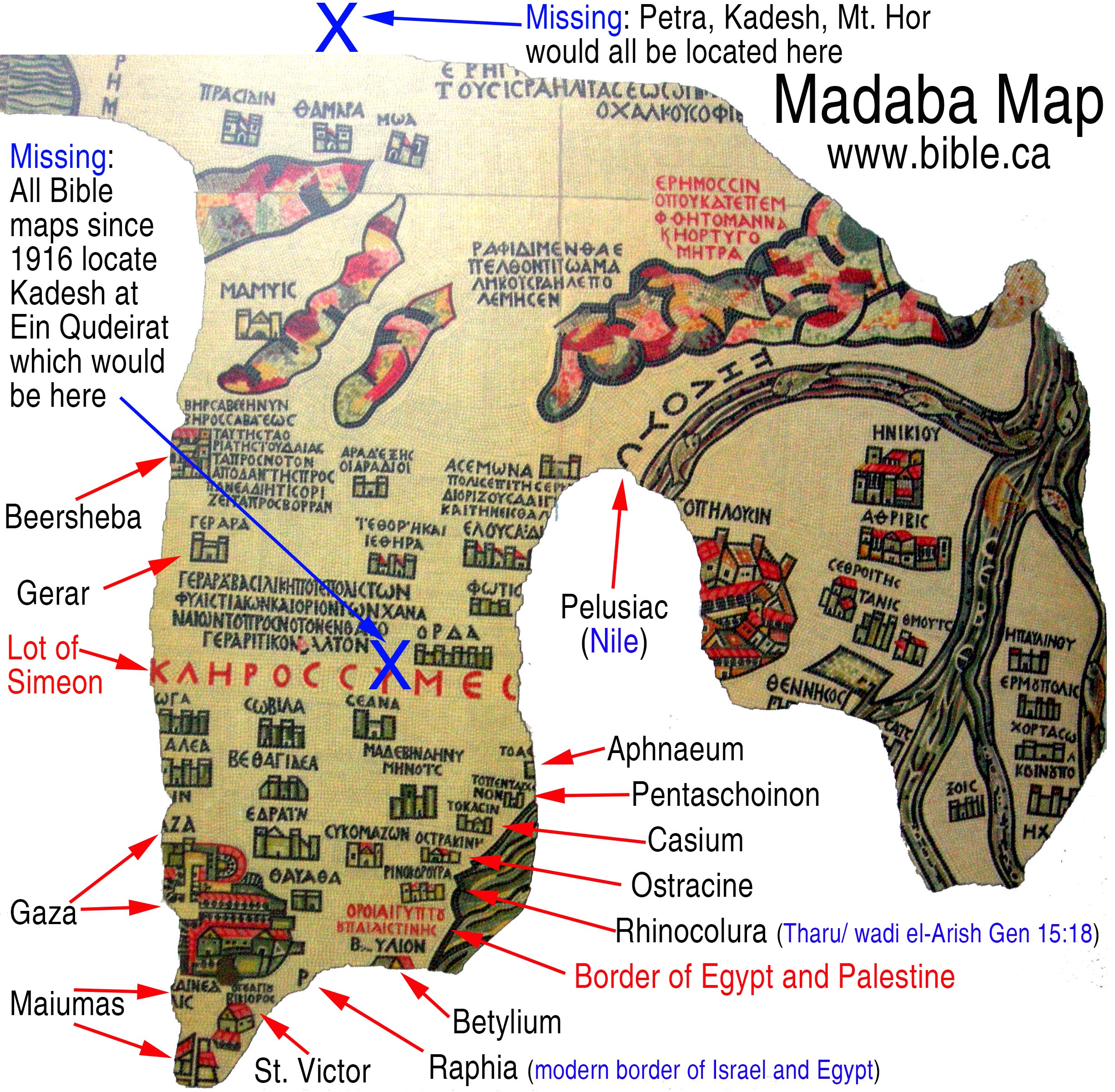
- Missing entirely from the Madaba Map are the Red Sea, Mt.
Sinai and Petra/Kadesh Barnea. It would certainly be on the map, but was
vandalized by the Muslims in 700 AD. Since we know these locations would
be on the map, they must have been the primary targets of defacement since
they document and affirm Jewish History. Petra is not on the Madaba map
and it most certainly would have been. Petra is where Eusebius located
Kadesh Barnea, the Mt. Hor, the rock Moses struck, the place Miriam died.
It would have been located in a section that is missing. We would expect
it to be directly above Praesidium, Thamara, Moa and above and to the left
of "The desert where the Serpent of brass saved the Israelites".
E. Modern sources who affirm Kadesh is at Petra:
- 1856 AD Arthur Penrhyn Stanley: "It [Mt Hor at Petra] is one of the very few spots connected with the wanderings of the Israelites, which admits of no reasonable doubt." ... "If there be any ground for this conclusion, Petra assumes a new interest. Its rock-hewn caves may have served in part for the dwellings, in part for the graves of the Israelites ; it is dignified as the closing scene of the life both of Miriam and Aaron". ... Is it too much to suppose that this point and Mount Hor were long regarded as the two sacred spots-of Petra ; that the scene of the death and sepulture of Aaron was designedly fixed in view of this, the innermost sanctuary of the Holy Place of " Kadesh ; " that this sanctity was retained through the successive changes of Pagan and Christian worship; and that the pilgrims of the Desert mounted these time-worn steps, and traced their inscriptions upon the rock, on their way to the only spot, whence they could see the grave of Aaron?" (Sinai and Palestine, in connection with their history, Arthur Penrhyn Stanley, 1856 AD, p84-99) Note: In 1901 AD, Robinson comments on Stanley, who said Kadesh was at Petra: "Stanley in his Sinai and Palestine (pp. 92-8) identifies Sela' or Petra with Kadesh, which is absurd." (Modern Kadesh or Ein Kadis, George L. Robinson, The Biblical World, Vol. 17, No. 5., May, 1901AD) Of course, there is nothing absurd about Petra being Kadesh. Stanley's ill informed belief that the city carved in stone we see today, like the "Treasury" dates back to the Exodus is indeed absurd! Stanley was wrong to suggest that Petra as we see it today, is the result of the Hebrews in 1446 BC when in fact the city we see today was carved by the Nabataeans in 350 BC. But Stanley was right in correctly locating Kadesh at Petra. He was a lone voice of truth, who needed the help of modern archeology to make the correct conclusions we are making today almost 150 years later.
- In 1867 AD Keil & Delitzsch state they are certain that Mt. Hor is located at Petra. In a most puzzling confusion, Keil & Delitzsch located Kadesh at Ein Qedeis, but located Mt. Hor 100 km east of Qedeis, at Petra. Both Kadesh and Mt. Hor were on the border of Edom and Mt. Hor was only "one stop" from Kadesh: Numbers 20:22; 33:37. This makes it impossible for Kadesh to be located 100 km west of Mt. Hor at Qedeis The border of Edom cannot be both the Arabah valley AND at Ein Qedeis! Keil & Delitzsch write: "Death of Aaron at Mount Hor. - The Israelites left Kadesh [which Keil & Delitzsch believed was at Ein Qedeis), and passed along the road just mentioned to Mount Hor. This mountain, which was situated, according to Num. 33:37, on the border of the land of Edom, is placed by Josephus (Ant. iv. 4, 7) in the neighbourhood of Petra; so also by Eusebius and Jerome: "Or mons, in quo mortuus est Aaron, juxta civitatem Petram." According to modern travellers, it is Mount Harun, on the north-western side of Wady Musa (Petra), which is described by Robinson (vol. ii. p. 508) as "a cone irregularly truncated, having three ragged points or peaks, of which that upon the north-east is the highest, and has upon it the Muhammedan Wely, or tomb of Aaron," from which the mountain has received its name "Harun," i.e., Aaron (vid., Burckhardt, Syr. pp. 715, 716; v. Schubert, Reise, ii. pp. 419ff.; Ritter, Erdkunde, xiv. pp. 1127ff.). There can be no doubt as to the general correctness of this tradition; for even if the Mohammedan tradition concerning Aaron's grave is not well accredited, the situation of this mountain is in perfect harmony with the statement in v. 23 and Num. 33:37, viz., that the Israelites had then reached the border of the land of Edom." (Keil & Delitzsch, 1867, Num. 20:22-29)
- In 1871 AD, Jamieson, Fausset, Brown give Petra as one of two locations on the Arabah Valley for Kadesh: "they came ... to Kadesh—an important encampment of the Israelites. But its exact situation is not definitely known, nor is it determined whether it is the same or a different place from Kadesh-barnea. It is supposed to be identical with Ain-el-Weibeh, a famous spring on the eastern side of the desert [Robinson], or also with Petra [Stanley]. (Jamieson, Fausset, Brown, 1871 AD, Num 13:26)
- In 1910 AD, Nathan Schmidt, after considering Weibeh, Kades and Qudeirat, rejected them all and concluded that Kadesh was in fact at Petra: In choosing the location of Kadesh, Schmidt rejected Qudeirat in favor of Petra in 1910 the same way that Stanley rejected Weibah in favor of Petra in 1856: "It seems to me even more probable that Petra was the original scene of these stories. Here the great Deliverer (Cp. my article "The Jerahmeel Theory and the Historic Importance of the Negeb," Hibbert Journal, vi. 2 January, 1908, pp 339ff.) performed the miracle of piercing the rock and sending the wonderful stream through the Sik, and here his older brother Aaron died on the peak of Mt. Hor. In earlier times the gulf of 'Akabah reached farther north than it does to-day [note: Schmidt is wrong about water levels. Solomon's fortress at Elat -Tell el-kheleifeh was built on a hill 500 meters from the shore of the Red Sea less than 12 feet above current sea level. This proves sea levels have not changed much in 3000 years.], and a passage from the eastern side over to El Tih may not have been as easy as it is at present. Nomadic tribes pushing northwest from the land of Midian no doubt found their way down into the Negeb through the defiles of Mt. Seir (Jebel Sharra). The Idumaean clans that camped around Moserah and Zin probably brought with them the traditions of their heroes. Their way from Sinai-Horeb to Kadesh Barnea and Mt. Halak is likely to have led them through the Valley of Moses and put the reputed resting place of Aaron in Petra." (Kadesh Barnea, Nathan Schmidt, Journal of Biblical Literature, Vol 29, no 1, 1910 AD, p75-76)
- "Yet ever since Dean Stanley in 1856 (Sinai and Palestine, pp. 152, 153, 161) identified Jebel Nebi Haroun with Mt. Hor, and Petra with Kadesh-Barnea, most commentators have adopted without question his conclusion. (The True Mount Hor, Jebel Maderah. George L. Robinson, The Biblical World, Vol. 31, No. 2., Feb., 1908, p 86-100)
- The sacred spring created by Moses, as described in Exodus accounts, has been equated with the Ain Mousa spring outside Petra although controversy exists as to its location (and historical accuracy) and sites in Sinai must also be considered. Biblical and Koranic references to the Petra area document use of water channels and springs by the inhabitants to maintain agriculture and settlements. Assyrian texts ascribed to the Sargonic era (715 BC) mention tent cities in this area. The earliest proto-Nabataean period (sixth century BC) began when Edomite agriculturalists assimilated nomadic tribal groups familiar with caravan-based trade activities. (The Water Supply of Petra, Charles R. Ortloff, Cambridge Archaeological Journal, 2005, 15:1:93-109)
Part III: The physical evidence at Petra:
A. Called "Petra" after the Rock Moses struck:
- Eusebius reported that you could visit Petra in 325 AD and still see the very rock that Moses struck: "Mt Hor: Mountain on which Aaron died near the city of Petra. There is now pointed out the rock which flowed for Moses (which Moses struck and gave water to the people)." (The Onomasticon, Eusebius, 325AD)
- The first appearance of the name Petra was immediately after the Hebrews vacated Kadesh in 1406 BC. The Edomites moved in and began to enjoy the blessing of the miraculous water that had flowed for 38 years. Since this was a place right on their door step, they obviously understood that this water was not flowing before Moses arrived. It is natural then for them to call the place "Sela", for the blessings of the life sustaining water originated with Moses staff striking the ROCK. The names Sela and Petra both mean "rock".
- The crevice at Petra is not unique to the Arabah valley area or the Negev, but it is the only one is called "Rock".
- Perhaps Petra was called Rock for reasons other than this was the place that Moses struck the Rock in 1446 BC. But given the ancient tradition associated with Petra that this is the place Moses struck the rock, the Siq is called the Wadi of Moses and the tomb of Aaron nearby, the most compelling reason Petra is called Rock, is because this is Kadesh Barnea.
- The treasury is located at Petra in the middle of a section that is at the bottom of a deep canyon area. It is possible that this particular area, or perhaps the Petra area in general was called "rock" because it was protected by high rock cliffs. This is not likely because it fails to explain all the other features connected with Biblical Kadesh, like Wadi Musa, Tomb of Aaron and Miriam etc. In other words, if the Petra was just called "Rock" like the "Rock of Gibraltar" is also called rock but has no other connections with Kadesh except it is called "Rock", then this might be a plausible explanation. Other places, like the Rock of Gibraltar are called Rock!
- However, we in 15 AD, Strabo actually explains that Petra was called Rock because of the geographic features of high rock cliffs that fortify the city below. But we need to keep in mind that Strabo was a Greek geographer and historian and was likely unaware of the Jewish history of Kadesh Barnea: "The metropolis of the Nabataeans is Petra, as it is called; for it lies on a site which is otherwise smooth and level, but it is fortified all round by a rock, the outside parts of the site being precipitous and sheer, and the inside parts having springs in abundance, both for domestic purposes and for watering gardens. Outside the circuit of the rock most of the territory is desert, in particular towards Judaea." (Strabo. Geography 16:4:21, 15 AD) Of course Strabo is almost 1406 years removed from the initial time Kadesh first was called "Rock", and this may in fact be his own guess as to why the place was called Rock.
- It seems to me even more probable that Petra was the original scene of these stories. Here the great Deliverer (Cp. my article "The Jerahmeel Theory and the Historic Importance of the Negeb," Hibbert Journal, vi. 2 January, 1908, pp 339ff.) performed the miracle of piercing the rock and sending the wonderful stream through the Sik, and here his older brother Aaron died on the peak of Mt. Hor. (Kadesh Barnea, Journal of Biblical Literature, Nathan Schmidt, Vol 29, no 1, 1910 AD)
B. "Wadi of Moses" is a remnant of the water that flowed:
There is an ancient tradition that the 1 km long Siq canyon at Petra is called, wadi of Moses.
|
|
"Kadesh Barnea ... Petra a city of Arabia. There Mariam went up and died, and there the doubting Moses struck the rock to give water to the thirsty people. (The Onomasticon, Eusebius, 325AD) "Mt Hor: Mountain on which Aaron died near the city of Petra. There is now pointed out the rock which flowed for Moses (which Moses struck and gave water to the people)." (The Onomasticon, Eusebius, 325AD) "Kadēs. Where the spring "of judgment" was. (The Onomasticon, Eusebius, 325AD, see Gen 14:7) Kades = Kadesh Barnea |
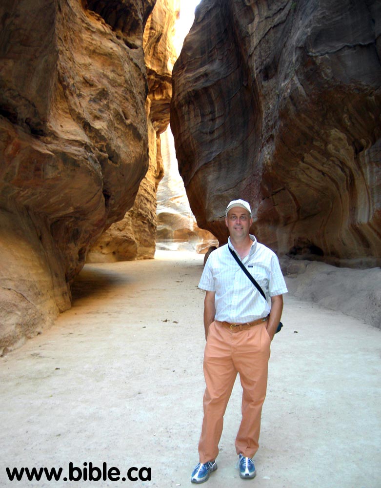
- "This is the Sik, or "cleft ;" through this flows-if one may use the expression-the dry torrent, which, rising in the mountains half an hour hence, gives the name by which alone Petra is now known amongst the Arabs-Wady Mousa. "For,"-so Sheykh Mohammed tells us- "as surely as Gebel Harun (the Mountain of Aaron) is so called from the burial-place of Aaron, is Wady Mousa (the Valley of Moses) so called from the cleft being made by the rod of Moses when he brought the stream through into the valley- beyond." It is, indeed, a place worthy of the scene, and one could long to believe it. Follow me, then, down this magnificent gorge-the most magnificent, beyond all doubt, which I have ever beheld. ... The Sik is unquestionably the great glory of Petra; but there is another point, on the other side, which struck me very much also, and which, if thoroughly explored, would, I think, be the most instructive and interesting spot in the place, You turn up a torrent-bed in the western cliffs (for torrent-beds from all sides pour down into this area in the heart of the hills), but soon leave it to ascend a staircase hewn out of the rocks, steps not absolutely continuous now, though probably they once were; broad steps glowing with the native colours, which conduct you through magnificent rocks, and along the banks of an almost second Sik, high up into the vast cluster of rocks which face Mount Hor on the north.". (Sinai and Palestine, in connection with their history, Arthur Penrhyn Stanley, 1856 AD, p84-99)
- "The name Wadi Musa derives from the legend of Moses
striking a rock here and creating twelve springs of water. The most
important spring, 'Ain Musa, is located alongside the main road, at the
point where the roads from Shobak and Aqaba converge at the eastern
entrance of the town." (Petra:
a guide to the capital of the Nabataeans, Rami G. Khouri, 1986,
p11-27, p41-44)
- Although In 15 AD, Strabo noted that many springs and an abundance of water, today there are very few springs flowing at Petra: "The first people above Syria who dwell in Arabia Felix are the Nabataeans and the Sabaeans. They overran Syria before they became subject to the Romans; but at present both they and the Syrians are subject to the Romans. The metropolis of the Nabataeans is Petra, as it is called; for it lies on a site which is otherwise smooth and level, but it is fortified all round by a rock, the outside parts of the site being precipitous and sheer, and the inside parts having springs in abundance, both for domestic purposes and for watering gardens. Outside the circuit of the rock most of the territory is desert, in particular towards Judaea. Here, too, is the shortest road to Hiericus, [Jericho] a journey of three or four days, as also to the grove of palm trees, a journey of five days. Petra is also ruled by some king from the royal family; and the king has as Administrator one of his companions, who is called "brother." It is exceedingly well-governed; at any rate, Athenodorus, a philosopher and companion of mine, who had been in the city of the Petraeans, used to describe their government with admiration, for he said that he found both many Romans and many other foreigners sojourning there, and that he saw that the foreigners often engaged in lawsuits, both with one another and with the natives, but that none of the natives prosecuted one another, and that they in every way kept peace with one another." (Strabo. Geography 16:4:21, 15 AD)
- The stone road seen below in part, dates back to the
Nabataean era. Modern archeologists had to remove 15 feet of deposits to get
down to this road. This proves that the canyon has stopped eroding in
depth. The question is whether the canyon was formed rapidly or slowly
over time. The Mammoth Caves in Kentucky, for example, are examples of
relics of the past. They were formed at some time in the past, but have
stopped eroding or enlarging. Perhaps the Siq was formed rapidly and what
the Nabataeans encountered was a relic canyon that had already stopped
eroding.
- "When rain falls upon a basin 54 square miles (92 square kilometers) in area, on hard terrain that absorbs very little, water will amass in a few hours in considerable and sometimes dangerous amounts. Rainfall into the basin of Petra flows along the course of the unchanneled Wadi Musa, which also continually carried water into the city from the Ain Musa, the most abundant spring in the area." (Petra: lost city of the ancient world, Christian Augé and Jean-Marie Dentzer, 2000 AD, p 59-62)
- "These installations were complemented by a network of long-distance conduits that carried water to Petra from the most important springs in the area, which rose several kilometers away at the edge of the plateau, to districts well above the water level of the Wadi Musa. This system reveals an impressive technical mastery. A project of such large scope was surely beyond the capabilities of a small community." (Petra: lost city of the ancient world, Christian Augé and Jean-Marie Dentzer, 2000 AD, p 59-62)
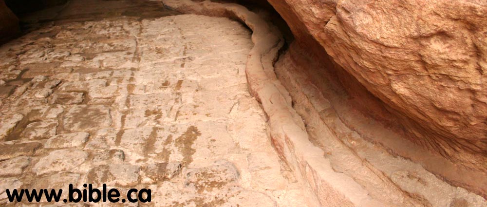
- Nabataean water conduit: "At eye-level, just above
the kerb of the road, are the intact remains of the pressure-pipe water
system made of ceramic pipes that fit snugly into one another. They were
buried into a ledge cut out of the rock, and covered with a combination of
stone chips and mortar. You can trace the pressure-pipe system here for
about ten metres, while the rock-cut water channel is clear on the other
side of the Siq. The better preserved rock-cut water channel can be traced
to the left for almost the entire length of the Siq. Its level varies
today because the path is usually higher or lower than the original level
of the paved road, due to the erosion of the bed of the Siq by water
action, and its subsequent silting up." (Petra:
a guide to the capital of the Nabataeans, Rami G. Khouri, 1986, p11-27,
p41-44)
- "Another impressive public project was the protection of the narrow passage of the Siq from the violent flooding to which it was exposed. This was accomplished by diverting the overflow of the Wadi Musa through a tunnel into a tributary. The Nabataeans clearly mastered water conservation and management at Petra in progressive stages." (Petra: lost city of the ancient world, Christian Augé and Jean-Marie Dentzer, 2000 AD, p 59-62)
- Populations settle near large reliable water supplies. For example in Jerusalem today the Gihon spring flows large amounts of clean cold water. We find a major city built directly over top of this spring. David built his fortress gates to primarily protect the water. So in the search for Kadesh, we could look for evidence of past or present civilizations. Interestingly, we find just such a large civilization at Petra.
- "Flash floods: It rarely rains in Petra, but occasionally rain up to thirty miles away can send a wall of water hurtling through the Siq gorge. In April 1963, 28 travelers were caught in the Siq and all were drowned. Two landrovers were deposited many feet up the sides of the canyon on a ledge, where they remained as gruesome warnings for several years. Recently a barrage dam has been built across the mouth of the Siq to ensure year-round safety (insha Allah) by diverting the water through a tunnel especially cut through the sides of the mountain by the Nabataeans in the first century BC. Presumably they had the same problems as well as wishing to utilize every available drop of water." (Petra A traveler's Guide, Rolalyn Maqsood, 1994 AD, p13-73, p125-129, p159)
- "At its peak, Petra's population was about 30,000, an astonishing density made possible in the arid climate by clever engineering. Petrans carved channels through solid rock, gathering winter rains into hundreds of vast cisterns for use in the dry summers. Many are still used today by the Bedouin." (Reconstructing Petra, Smithsonian: June 2007; Vol 38, Num 3, Andrew Lawler )
C. The nine springs of Petra:
|
|
There are nine known springs at Petra with their rate of flow today: 1. Ain Mousa: 20-40 m3/hr |
- There were 2.5 million Hebrews at Kadesh. If each needed 40 litres per day for basic survival, that means that the river of Moses would need to supply 100 million litres of water every day. That is equal to 100,000 m3/day. Ain Mousa flows at a maximum rate today of 40 m3/hr or 960 m3/day. Since the 2.5 million Hebrews needed 100,000 m3/day, this means that Ain Mousa could supply less than 1% of the Hebrews daily water needs based upon current flows.
- The entire water system at Petra, at it height of development at the time of Christ (30 AD) could supply "perhaps 100 m3/hr in total if less conservative leakage estimates are used." (The Water Supply of Petra, Charles R. Ortloff, Cambridge Archaeological Journal, 2005, 15:1:93-109)
- This means that Petra, at its peak in the first century AD, using human means to exploit all water resources, would supply only 2400 m3/hr of the 100,000 m3/hr needed or only 2.5%. Stated differently, we would need 40 Petra water systems to supply the 2.5 million Hebrews who lived at Petra for 38 years. Only a miracle could do this.
- Niagara falls, with a flow rate of 5,830m3/sec, could supply the daily needs of 2.5 million Israelites every 17 seconds. The Upper Grand river in Ontario Canada, in the winter when flows are very slow, flows at 6 m3/s which amounts to 500,000 cubic meters per day. That means that a river 1/5 the size of the Upper Grand River would supply all the Hebrews needs every day.
- "While water storage was a partial key to the city's survival, a number of springs internal and external to the city (Ain Mousa, Ain Umm Sar'ab, Ain Braq, Ain Dibdiba, Ain Ammon, al Beidha, Ain Bebdbeh) provided water that was channelled and/or piped to the city. This constituted the main water supply of the urban centre." (The Water Supply of Petra, Charles R. Ortloff, Cambridge Archaeological Journal, 2005, 15:1:93-109)
- "The main Petra water supply originated from the Ain Mousa spring about 7.0 km east of the town of Wadi Mousa (D;1) combined with waters of the minor Ain Umm Sar'ab spring. This supply still serves the modern town and the associated tourist complex located outside the Siq entrance" (The Water Supply of Petra, Charles R. Ortloff, Cambridge Archaeological Journal, 2005, 15:1:93-109)
- Petra in its peak, could supply 100 m3/hr: "Storage water and other springs would add yet further capacity to arrive at a yet higher flow rate — perhaps 100 m3/hr in total if less conservative leakage estimates are used." (The Water Supply of Petra, Charles R. Ortloff, Cambridge Archaeological Journal, 2005, 15:1:93-109)
- "The basic daily needs for water for survival is .04 m3/day: "For a city of 30,000 inhabitants (Guzzo & Schneider 2002), at least 0.04 m3/day (40 litre/day) would have been available on a per capita basis, which is minimal to maintain hygienic standards for an urban population." (The Water Supply of Petra, Charles R. Ortloff, Cambridge Archaeological Journal, 2005, 15:1:93-109)
- "The Romans used .6 m3/day per person: "If we add public use [at Petra] in the form of fountains, watering troughs, baths, water gardens and workshops, per capita water availability would have been well within the Rome urban water usage rate of 0.6 m3/day per person (Butterfield 1964)."(The Water Supply of Petra, Charles R. Ortloff, Cambridge Archaeological Journal, 2005, 15:1:93-109)
- "Survival in hot climates requires water intake per person of about 0.003 m3/day." (The Water Supply of Petra, Charles R. Ortloff, Cambridge Archaeological Journal, 2005, 15:1:93-109)
- Domestic use of water is 35.8 billion cubic meters of water per day. (World Bank, 2000) The population of the USA in 2000 from the census bureau is 281,421,906. That means that the per capita use of water (excluding industrial and agricultural) is .13 cubic meters of water per day per person in the USA. Since one cubic meter of water is equivalent to 264.17 gallons U.S. that means Americans consume for domestic purposes, 35 gallons of water per day per person or 132 litres per day per person.
- "Early phases of urban Petra relied upon open channel water delivery from the Ain Mousa spring outside the city along a direct path through the Siq. The water channel traversed the entire length of the city before exiting into Wadi Siyagh. Placement of this system required diversion of the intermittent Wadi Mousa River, that (previously) passed through the Siq, by means of dam and tunnel construction. ... Since the open channel in the Siq ran along a path at about the same height as the lowest Wadi Mousa riverbed, its ability to supply water to outlying urban zones above the riverbed was limited." (The Water Supply of Petra, Charles R. Ortloff, Cambridge Archaeological Journal, 2005, 15:1:93-109)
- "In early phases of Nabataean urban development predating the construction of pipeline systems, the main potable water supply derived from an open channel (2 to 2.5 m wide and 1.0 m deep) transporting Ain Mousa spring water through the Siq (C;1). This channel (dashed line, 29 in B;2) extended through the urban core of the city as far as Q'asr al Bint (29) with final drainage into the Wadi Siyagh (A;2). Dam and flood bypass tunnel construction at the Siq entrance, together with infilling and paving of the Siq floor to reduce flooding, has left the channel under the current pavement surface. This pavement is attributed to Nabataean construction under Aretas IV and later Roman paving efforts. The accumulation of flood debris following the city's abandonment for many centuries, in addition to modern attempts to dam and infill the front of the Siq to limit floodwater incursion from Wadi Mousa, have hidden this channel. Recent excavations in front of the Treasury to 5 m depth have, however, revealed remnants of this early open channel as well as early tombs cut into mountain walls antedating later Treasury construction. Hexagonal paving slabs and a water basin existed in front of the Treasury location in this early phase (Taylor 2001). While this channel provided water to early phases of the city, the later concentration of urban settlement in areas north and south of Wadi Mousa (B;2) replete with temple, administrative, commercial and civil structures, indicates a transition towards full city status and a hierarchical, stratified and cosmopolitan society involved in trade and commerce. This created demands to increase water supply and distribution to spreading urban settlement areas resulting from population increase. There was also perhaps a desire to match the city's prosperity from trade with appropriate symbols of success. Extensive use of pipelines followed to bring larger amounts of water to areas not reachable by the old, low elevation, open-channel system. Pipeline systems, however, introduced new design complexities that involved knowledge of ways to maintain a stable flow whose maximum (theoretical) flow rate matched (or exceeded) the supply spring flow rate." (The Water Supply of Petra, Charles R. Ortloff, Cambridge Archaeological Journal, 2005, 15:1:93-109)
- "While runoff capture probably supplied the Zurraba reservoir, local spring sources, including Ain Mousa, were also important in the early phase of city development and may have also contributed water to the reservoir. Although reservoir water could be used to supplement the Siq channel, Ain Mousa water supplies were later switched to a piping system and the open channel was abandoned." (The Water Supply of Petra, Charles R. Ortloff, Cambridge Archaeological Journal, 2005, 15:1:93-109)
- "The Ain Mousa spring, on the other hand, provided the continuous supply for the Nymphaeum through piping supported in a carved channel through the Siq (Figs. 5a & b) that replaced the earlier open channel. The Zurraba reservoir thus served as a backup system for rapid delivery of large volumes of water at short notice to the Jebel el Khubtha cisterns and served to augment the continuous, but declining, water supply to the Nymphaeum from the Ain Mousa spring during dry seasons." (The Water Supply of Petra, Charles R. Ortloff, Cambridge Archaeological Journal, 2005, 15:1:93-109)
- "In practice, owing to the many mortared joints between the 0.3 m terracotta piping segments (perhaps of the order of 30,000) along the 8 km length of pipeline, and assuming, for a (very) conservative estimate, a 50 per cent leakage rate, the deliverable volumetric flow rate can be readjusted to at least 45 m3/hr." (The Water Supply of Petra, Charles R. Ortloff, Cambridge Archaeological Journal, 2005, 15:1:93-109)
- "Intermittent springs located on Umm el Biyara (A; 1,2) may also have been important in ancient times; the Arabic name for this mountain translates as 'Mother of Springs'. As previously mentioned, the Siq open channel was abandoned in late Nabataean phases and replaced by a pipeline system (Figs. 5a & b) that extended to the area opposite the theatre district (B;1) and ended at the Nymphaeum. Thus at least two separate supply lines led to the Nymphaeum to ensure supply redundancy. The construction of the Siq pipeline system is generally attributed to Malichus II or his predecessors, Aretas IV or Obodas III, in the first century BC or early first century AD (Guzzo & Schneider 2002)." (The Water Supply of Petra, Charles R. Ortloff, Cambridge Archaeological Journal, 2005, 15:1:93-109)
- "The Wadi Siyagh spring, even today, is adequate for the local needs of scattered rural settlements in this area." (The Water Supply of Petra, Charles R. Ortloff, Cambridge Archaeological Journal, 2005, 15:1:93-109)
- "The piping systems east of the Great Temple reflect late Roman modifications to supply additional water for market and commercial structures along the Romanized Cardo.
- "To examine flow stability in the Siq north-side piping, sample computer models were made of a 1220-m-long section with 14.0-cm-diameter piping inclined at a 2.5 degree angle with and without internal roughness. The Ain Mousa spring had a high flow rate which the Siq piping system must have accommodated." (The Water Supply of Petra, Charles R. Ortloff, Cambridge Archaeological Journal, 2005, 15:1:93-109)
- "A third criterion requires that the flow rate is sufficiently high to accommodate urban-core water needs for a population of 30,000. A further criterion is minimization of leakage." (The Water Supply of Petra, Charles R. Ortloff, Cambridge Archaeological Journal, 2005, 15:1:93-109)
- "The predicted 35 m3/ hr flow rate is consistent with current-day Ain Mousa flow rates (Markoe 2003) of 20-40 m3/hr although past rates cannot be known with certainty." (The Water Supply of Petra, Charles R. Ortloff, Cambridge Archaeological Journal, 2005, 15:1:93-109)
- "For estimates of total water flow into the city, we may conservatively assume a north-side supply approximately one third that of the south-side rate owing to the less robust south-side springs. Assuming a combined flow rate between the Siq and Wadi Shab Qais reservoir release lines to be about 40 m3/hr, then the city could receive at minimum an estimated 50 m3/hr from these sources. Additional sources [Ain Braq (0.8 m3/ hr), Ain Dabdabah (2.5 m3/hr), Ain Ammon and Ain Siyagh (<1.0 m3/hr)] increase this estimate. Storage water and other springs would add yet further capacity to arrive at a yet higher flow rate — perhaps 100 m3/hr in total if less conservative leakage estimates are used. For a city of 30,000 inhabitants (Guzzo & Schneider 2002), at least 0.04 m3/day (40 litre/day) would have been available on a per capita basis, which is minimal to maintain hygienic standards for an urban population. If we add public use in the form of fountains, watering troughs, baths, water gardens and workshops, per capita water availability would have been well within the Rome urban water usage rate of 0.6 m3/day per person (Butterfield 1964). Survival in hot climates requires water intake per person of about 0.003 m3/day. Surplus water beyond human survival needs is hence available by these estimates." (The Water Supply of Petra, Charles R. Ortloff, Cambridge Archaeological Journal, 2005, 15:1:93-109)
D. "City of the Dead", a relic from Exodus graves of 3.5 million Hebrews
- If there be any ground for this conclusion, Petra assumes a new interest. Its rock-hewn caves may have served in part for the dwellings, in part for the graves of the Israelites (Sinai and Palestine, in connection with their history, Arthur Penrhyn Stanley, 1856 AD, p84-99)
- Why did they call it Kadesh? First is the connection with the dead. From the time of Joseph, who demanded his mummified body be buried in Canaan 500 years after he died, down to the present day, Jews place great holiness on their dead.
- 2 million Hebrews died at "Kadesh" which was called holy because it was where the entire nation was buried after 38 years in the wilderness: "your corpses will fall in this wilderness, even all your numbered men, according to your complete number from twenty years old and upward, who have grumbled against Me. 'Surely you shall not come into the land in which I swore to settle you, except Caleb the son of Jephunneh and Joshua the son of Nun. 'Your children, however, whom you said would become a prey—I will bring them in, and they will know the land which you have rejected. 'But as for you, your corpses will fall in this wilderness. 'Your sons shall be shepherds for forty years in the wilderness, and they will suffer for your unfaithfulness, until your corpses lie in the wilderness. 'According to the number of days which you spied out the land, forty days, for every day you shall bear your guilt a year, even forty years, and you will know My opposition. 'I, the Lord, have spoken, surely this I will do to all this evil congregation who are gathered together against Me. In this wilderness they shall be destroyed, and there they will die.' "" Numbers 14:29-35 (see also: Num 26:64-65; Deut 1:34-35; Psalm 106:26; 1 Cor 10:5)
- Today, in modern Judaism, the "Burial Society" is called the "Chevra Kaddisha" (Chevra = society; Kaddisha = holy). Jews have always place extreme importance on burial. Modern communities of Jews in Canada and the USA have been known to buy land for a cemetery, before they buy land for a synagogue. It seems odd that they would call their "undertakers" and "funeral homes" the "holy society". Why would they not call it the "burial society". There is a word in Hebrew for burial, but they chose the word "holy" instead. This odd choice of words is an ancient relic tradition that dates back to the exodus and the 38 years they spent at "Kadesh Barnea" (holy in the wilderness). Why would they call the place holy (kadesh)? Because the Jews spent 38 years there and 1.5 million Jews died and where buried at Kadesh. This all fits nicely with our view that Kadesh Barnea was located at or near Petra. Archeologists refer to Petra as "the city of the dead" "the city of tombs". We believe the time the Hebrews spent at Kadesh, and the burial of the dead at that location, is where modern Jews trace their tradition of calling their undertakers a "Burial Society" or in Hebrew: "Chevra Kaddisha" (holy society).
- This brings us to Petra. It is known as, "the city of tombs". It is unique in the entire world! Why? Because no other culture on earth lived on manna and miraculous water for 38 years.
E. Archeology finds evidence of ancient inhabitants at Petra
- "Even before the historical period, however, the Petra region was inhabited by Stone Age people who exploited its natural vegetation and wildlife. Diana Kirkbride's pioneering work at Beidha has revealed the presence of an important Neolithic village from the 7th millennium BC, along with traces of even earlier Natufian camps from the 9th and loth millennia BC. Recent surveys and excavations in the Petra area by a West German team from Tubingen University, headed by Hans Peter Uerpmann and Hans Georg Gebel, have discovered a handful of new settlements, seasonally occupied campsites and rock shelters from the same closing millennia of the Stone Age." (Petra: a guide to the capital of the Nabataeans, Rami G. Khouri, 1986, p11-27, p41-44)
- "Pre-history: The Petra region has been occupied since the earliest of times, and there was a settled community at Aklat and Beidha (suburbs of the city in later times) as early as 7000 BCE. Our historical information about the people who inhabited the Petra region before the third millennium is very sparse, coming almost exclusively from the discoveries of excavators." (Petra A traveler's Guide, Rolalyn Maqsood, 1994 AD)
- "THE FIRST INHABITANTS: A million years ago Early Palaeolithic man hunted elephant, deer and other animals throughout the mountains and valleys and deserts of Jordan. Camp sites, occasional homes of Middle Palaeolithic groups around 80,000 to 40,000 years ago, occur in several places in the Petra area, together with some artefacts of a hunter-gatherer economy. By 17,500 BC some groups had so defined their pattern of living that they occupied one place in winter, and another (or several others) during the hot, dry months. One such seasonal encampment, established by a Natufian group some 12,000 years ago, lies within a few flint-headed arrow-shots of Petra itself, at a place now known as Beidha. Then, around 7000 BC, some more sophisticated Neolithic people occupied the abandoned site and over the next 500 years lived here in a settled agri-cultural community. In the millennia that followed, through the Chalcolithic and Early Bronze Ages, this mixed pattern continued, with agricultural settlements alongside nomadic groups who moved about with their flocks and tents. By the Middle/Late Bronze Age, settled villages are no longer found in the south, though several occur in better agricultural areas further north. About 1800 BC, some Egyptian execration texts (a group of inscriptions intended magically to harm Egypt's adversaries, whether actual or potential) refer to 'rulers' of northern areas of Jordan; but for the land of Kushu in the south - later to become known as Edom - they talk of `chiefs' of 'clans' of itinerant pastoralists. This tent-dwelling nomadic pattern of life continued in southern Jordan until the seventh century BC." (Petra, Jane Taylor, 2005, p13)
- "Excavations begun in 2003 have shown that some earlier tombs had their tops removed to make way for the Treasury. They stand at its foot, four metres below the present level of the natural courtyard over which it presides. It was at first thought they were converted into cisterns, but later work showed that they continued to function as tombs. If the Treasury towers imposingly above us today, imagine the impact it would have had on Nabataeans and their visitors when they looked at it from four metres lower than we do. For whatever the purpose of this monument, its siting at the end of the forbidding twilight of the Siq was clearly designed to strike wonder into all who entered the Nabataean capital." (Petra, Jane Taylor, 2005, p57)
F. Ancient trade routes near Petra:
- At the time of the exodus (1446 BC), Petra was not a major trade center and likely had no trade routes running through it till much later.
- In 50 BC, at height of Nabataean development, Petra was a
center and a hub for trade. Perhaps mainly because it was their capital
city.
- "There was also an ancient trade-route that led from Sela or Petra to the Wadi Arabah, then south to Ezion-geber: Elath (or Aila as the Nabataean-Roman-Byzantine site which took its place farther to the east, nearer modern Aqaba, became known later on), and westward via Qurnub to Gaza and Ascalon. This trade-route from Sela or Petra to Gaza and Ascalon assumed particular importance during the Nabataean period. However, it was undoubtedly of large importance also during the times of the Edomite kingdom and the United and Divided Kingdoms of Israel and Judah. This was probably the route used for slave-traffic between Gaza and Edom, mentioned, for instance, in Amos 2:6." (The Civilization of the Edomites, Nelson Glueck, 1947 AD)
G. Pottery of Nabatean Petra:
"Conclusions: 5.1 Pottery manufacture in Petra: 1. The samples in G XV, the sample group local to Petra (in section 4.7), span a long period of time, from late Hellenistic (around the beginning of the second century B.C.) to late Byzantine (around fifth-sixth century A.D.). This indicates that pottery production in Petra went on for at least that period, and that the same sources of clay were used throughout (although a Palestinian origin for some of the samples could not be ruled out, but could not be proven either, see section 4.8.1). 2. Khairy's assumptions that most of the coarse and painted wares from the Petra excavations originated in Petra (see sections 2.2 and 2.3.1) are supported by the fact that the majority of the cooking pots, and Nabataean red and painted wares analysed belong to G XV. 3. The Petra potters were highly selective in choosing and processing their clays. G XV is much more homogeneous than the clays from the Petra area, which spread out among ten sample groups (Table 4.15a in section 4.7). However, they used the same clays, and similar processing techniques, for making a range of different classes of pottery, from the very fine painted wares to the coarse cooking pots, lamps and figurines. 4. There may have been some specialisation in the production areas of Nabataean painted ware and lamps, with Petra (and the surrounding areas, maybe including Udhruh) specialising in the manufacture of painted ware, and other areas specialising in the production of lamps (see section 4.7)" (The Pottery from Petra: A Neutron Activation Analysis Study, Khairieh Amr, 1987)
H. The treasury (el-Khazneh) was built: 50 BC
- The Hebrews had long abandoned Petra for the promised land and the Edomites, whose borders were next to Kadesh. The Edomites then moved north into this "turn key" city that had serviced 2.5 million Jews for 38 years.
- The origin of the Nabataeans is unclear even today. However it seems obvious that Edomites clearly had something to do with the origin of the Nabataeans: "Three sources of evidence show influence from Edomite architecture which can be recognized in Nabataean architecture." (How Petra was Built, Shaher M. Rababeh, 2005, p223-227)
- By 300 BC, the city of Petra began to be occupied by the Nabataeans.
- By 200 BC, they had begun carving graves out of the rock.
- The treasury, was built in about 50 BC.
- "The Nabataeans had their own distinctive
architectural style which reflected both Hellenistic and Oriental
influences, the origins of which it is possible to suggest. However,
determining the origins of the techniques used to build them is not easy.
I found that some of these construction techniques were used in the same
way as throughout the Greco-Roman world, and were probably borrowed.
However, there are some technical features used by the Nabataeans which
indicate that they further developed and adapted these techniques rather
than merely borrowing them. At the same time, there are features not found
elsewhere. Others are the earliest known examples. Therefore, there is in
fact a whole range of possibilities, and the question is how it developed
and varied, and where within this range Nabataean construction practice
lay. It is not at present possible to establish chronological stages for
the different technical aspects because the monuments are packed into a
short period (from the last quarter of the 1St cent. BC to the early 2nd
cent. AD), and their exact dates of construction within this period are
still not absolutely certain." (How
Petra was Built, Shaher M. Rababeh, 2005, p223-227)
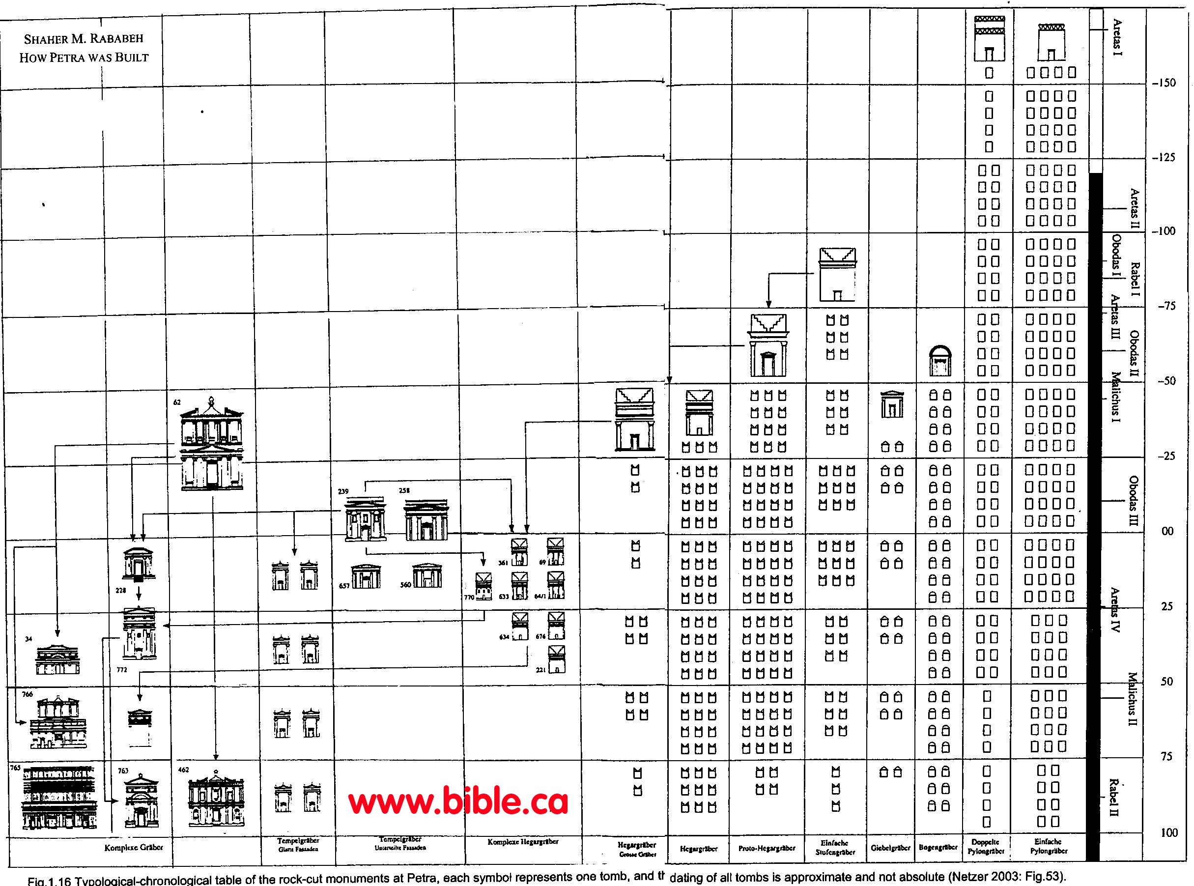
- "No one in the ancient world, outside Petra, ever carved a two-story rock-cut monument on this scale." (How Petra was Built, Shaher M. Rababeh, 2005, p223-227)
- "It seems more likely in principle to start this development from the simplest monuments and move in the direction of complexity. For this reason, contrary to what Schmid suggested, it is possible that carving some of the simpler (and usually smaller) rock-cut monuments in Petra namely the Pylon, the Step, Proto-Hegr, and Hegr type tombs began before the larger ones. This is now clear after the remarkable discovery of the tombs in front of el-Khazneh [treasury], which are classified stylistically as Proto-Hegr type. These were definitely carved before el-Khazneh, probably before the last quarter of the first century BC." (How Petra was Built, Shaher M. Rababeh, 2005, p223-227)
- "The builders were forced to develop the technical elements borrowed to make them suitable for their own use as the local materials required. Although the technique is borrowed, the result is Nabataean because of the properties of the materials and their limitations. Therefore, a lot of their techniques relate basically to the materials, from which everything came out. Perhaps the most straightforward example of this phenomenon is the use of the orthostates in the Qasr el-Bint (late 1st cent. BC, the earliest freestanding monumental building in Petra). This use could be an initial borrowing from Greek practice (coming with the Greek forms) which was later rejected because the quarries could not provide larger blocks because the stone was not suitable. A further example is the use of timber. It is expensive and so Nabataean builders used stone slabs in roofing. Another example is stone dressing which was not new but how the Nabataeans did it (with diagonal tooling) is unique to Nabataean architecture. All this leads to sum up that the Nabataeans had their own construction techniques, just as they had their own architectural style. It is right that they got some of their techniques from local sources or the Greco-Roman world, but they took them and they developed them in ways specific to Petra." (How Petra was Built, Shaher M. Rababeh, 2005, p223-227)
Conclusion:
1. For the serious Bible student, Petra is clearly the best choice for locating Kadesh Barnea.
a. The Bible clearly teaches that Kadesh was Transjordan between an area south of the Dead Sea to the Petra area.
b. Kadesh was not located Transjordan just north of the Red Sea (Elat) because this was the domain of Edom.
- Based upon history, geography and archeology , Kadesh Barnea is most likely located at Petra from ancient El Beidha located 5 km north of Petra, to Basta located 12 km SE of Petra.
- The Nabateans inherited and continued the ancient Hebrew tradition of Kadesh Barnea as a burial city and carved the modern tombs and the famous “Treasury” we see today.
- Mt. Hor is at Petra where Aaron was buried.
- There are ancient geographic traditions that a river called the “River of Moses” (Wadi Musa) was sourced by the “Spring of Moses” (Ein Musa) at Petra.
3. It is time to get a red pen and update all those inaccurate maps in the back of our Bible's that place Kadesh at Qudeirat.
|
|
Further reading: Library of research books and articles relating to the exodus route |

- Chronological History of the search for Kadesh
- (Sinai and Palestine, in connection with their history, Arthur Penrhyn Stanley, 1856 AD)
- (Petra: lost city of the ancient world, Christian Augé and Jean-Marie Dentzer, 2000 AD)
- (Kadesh Barnea, Journal of Biblical Literature, Nathan Schmidt, Vol 29, no 1, 1910 AD)
- (Petra: a guide to the capital of the Nabataeans, Rami G. Khouri, 1986)
- (Petra A traveler's Guide, Rolalyn Maqsood, 1994 AD)
- (Kadesh Barnea, Ain el-Qudeirat, A fortress from the time of the Judaean Kingdom, Rudolph Cohen, The Israel Museum, Jerusalem 1983 AD)
- (Reconstructing Petra, Smithsonian: June 2007; Vol 38, Num 3, Andrew Lawler )
- (The Lost Testament, David Rohl, 2002, p 223-227)
- Relief map of Petra by Philipp von Zabern, 1996 AD:
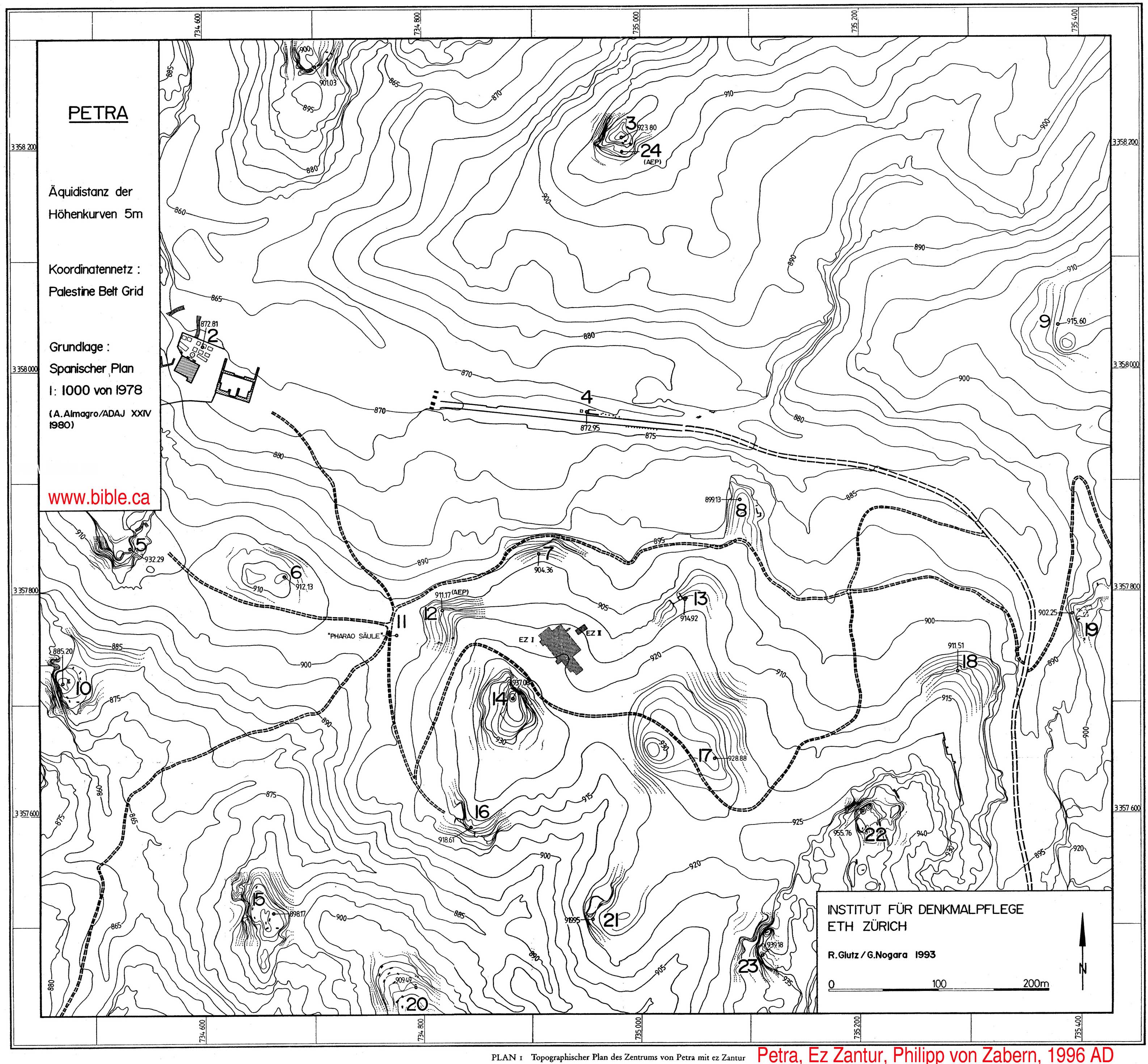
- Palestine and Syria. Handbook for Travelers, Karl Baedeker,
1912 AD:
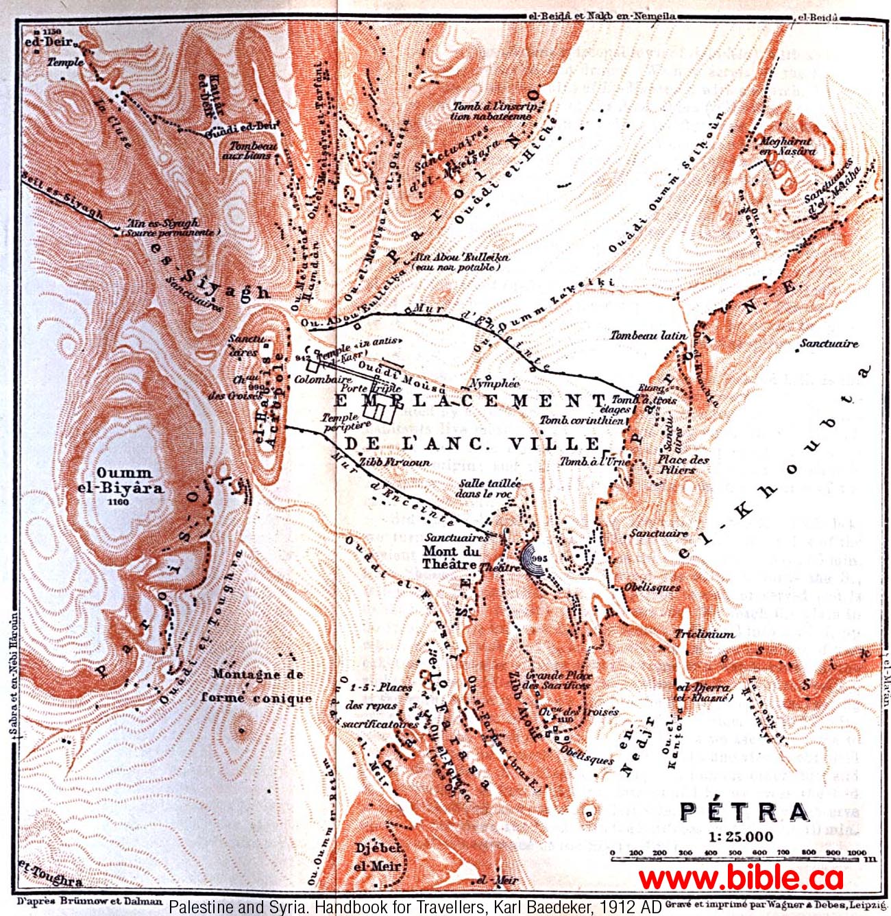
By Steve Rudd, 2006, 2019 AD: Contact the author for comments, input or corrections.
