Elat and Ezion-geber: Twin cities
|
|
|
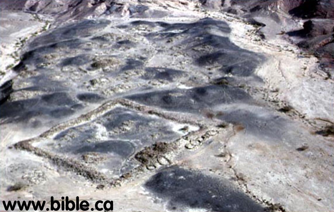
Tell el-kheleifeh Fortress at
Elat: (near Ezion-Geber)
(One of Solomon's network of military border fortresses)
|
|
|||
|
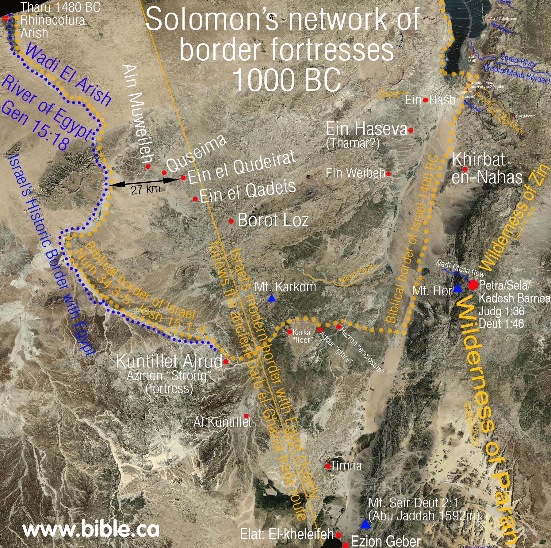
Introduction document: Solomon's network of military border fortresses |
|||
|
|
|||
Introduction:
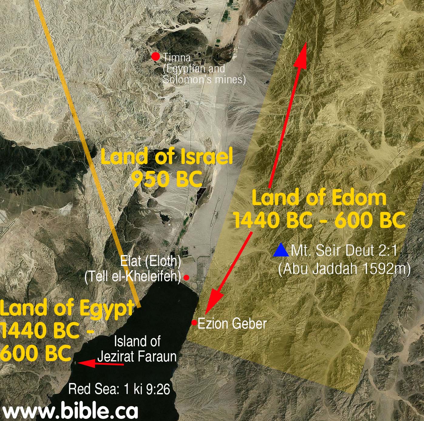
- This page deals with Ezion-Geber of the exodus route and Elat (Eloth) located nearby at tell el-kheleifeh.
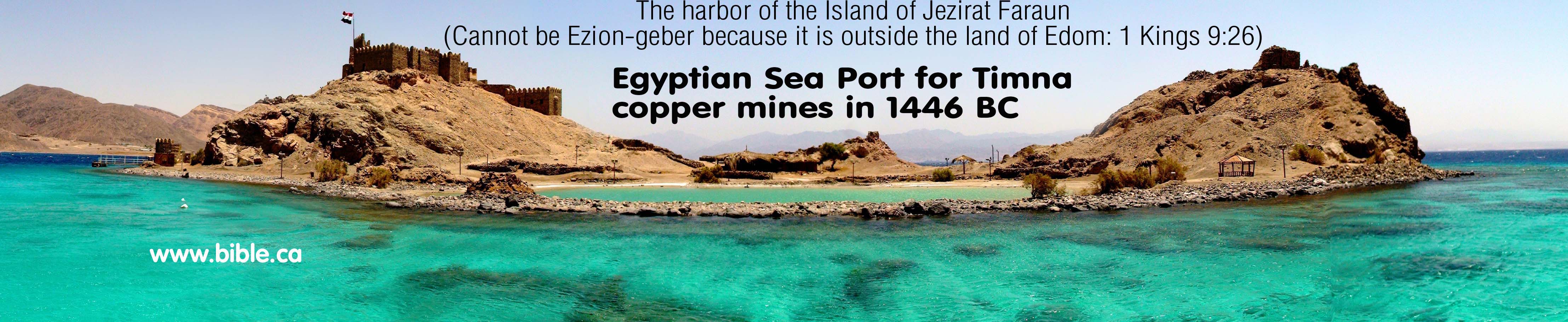
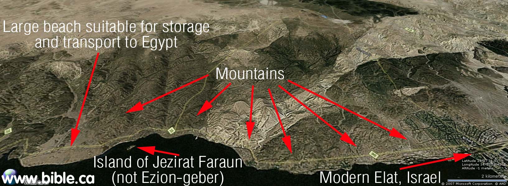
- Neither tell el-kheleifeh or the island of Jezirat Faraun are Ezion-geber. Tell el-kheleifeh is ancient Elat, Jezirat Faraun is an ancient Egyptian seaport "migdol" to support their mining operations of Timna in 1446 BC. (Details below)
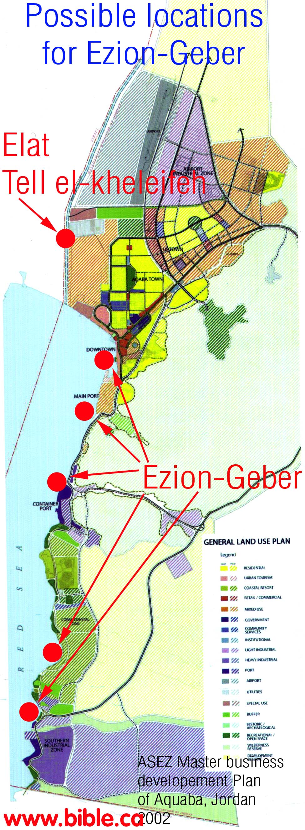
- Ezion-geber is still undiscovered, but likely located under the modern ship yards of Jordan.
- Both Elat and Ezion-Geber were two different border fortresses built by Solomon.
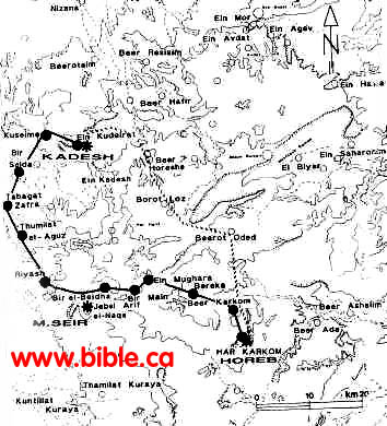
- Ezion-Geber is the only "stop" of the exodus route that is known for sure where it is located. (Num 33:36) Scripture says it was located on the shore of the Red Sea, in the land of Edom, very near Elat. Both Elat and Ezion Geber are located at the north end of the Gulf of Aqaba.
- One of the critical factors of Ezion-Geber, is that it was one stop before the 11 day journey from Mt. Sinai to Kadesh Barnea (Deut 1:2), by way of Mt. Seir. Mt. Sinai located at Jebel Al-Lawz in modern Saudi Arabia and Kadesh Barnea located at or near Petra fits perfectly, given they would pass right by Mt. Seir, the seat of transjordan Edomite territory.
- Ezion-geber, like Kadesh itself, must be on the edge of Edom's land. Archeologically, it can be proven that Edom was almost entirely transjordan until the time of the Babylonian captivity of 586 BC. This places Ezion-geber on the east side of Elat, not the west. If archeologists had merely read the Bible, they would have used it as a guide to look in the right place.
- "The first one to suggest the identification of Ezion-geber with Tell el-Kheleifeh was Fritz Frank. The small low mound is located approximately in the center of the north shore of the Gulf of Aqabah, midway between Jordanian Aqabah at its east end and Israeli Eilat at its west end. It is about 500 yards from the actual shoreline today and may have been some 300 yards or more several millennia ago. For all practical purposes it is possible to say that the shoreline has experienced no great change since Tell el-Kheleifeh was first occupied in the 10th century B.C." (Ezion-Geber, Nelson Glueck, Excavations at Tell el-Kheleifeh, 1965 AD)
- Nelson Gluecks was the first to excavate tell-el-kheleifeh between 1938-1940 AD. But in 1965 AD, he re-evaluated some of his conclusions and rejected the site as Ezion-geber: "We find ourselves compelled in their light and in view of new knowledge and some convincing criticisms of our initial reports to revise radically some of our original conclusions." (Ezion-Geber, Nelson Glueck, Excavations at Tell el-Kheleifeh, 1965 AD)
- Elat and Ezion-Geber are "sister cities": distinct, but very close to each other. "King Solomon also built a fleet of ships in Ezion-geber, which is near Eloth (Elat) on the shore of the Red Sea, in the land of Edom." 1 Kings 9:26
- Tell el-kheleifeh is ancient Elat in our opinion. Tell el-kheleifeh cannot be Ezion Geber of the exodus Route. Biblical Ezion Geber was located around the eastern bend of the east side of the Red Sea. It is likely as yet either undiscovered, or misidentified. We take the view the Biblical Ezion Geber is under the modern port of Aqaba, Jordan and will be difficult to locate since excavations are unlikely under a fully functioning modern sea port. The modern sea port is located directly over top of the one Solomon built.
- Notice that Ezion Geber is on the shore in the land of Edom: 1 Kings 9:26; 2 Chron 8:17. This means that Ezion Geber was located transjordan in modern Jordan and not in the modern Sinai Peninsula. We know this, because the Edomites never lived in the Negev until after the Babylonian captivity of 586 AD. Therefore, Ezion Geber was located on the east shore of the Gulf of Aqaba. Ezion Geber is probably not discovered yet, or is under modern the city of modern Aqaba, Jordan.
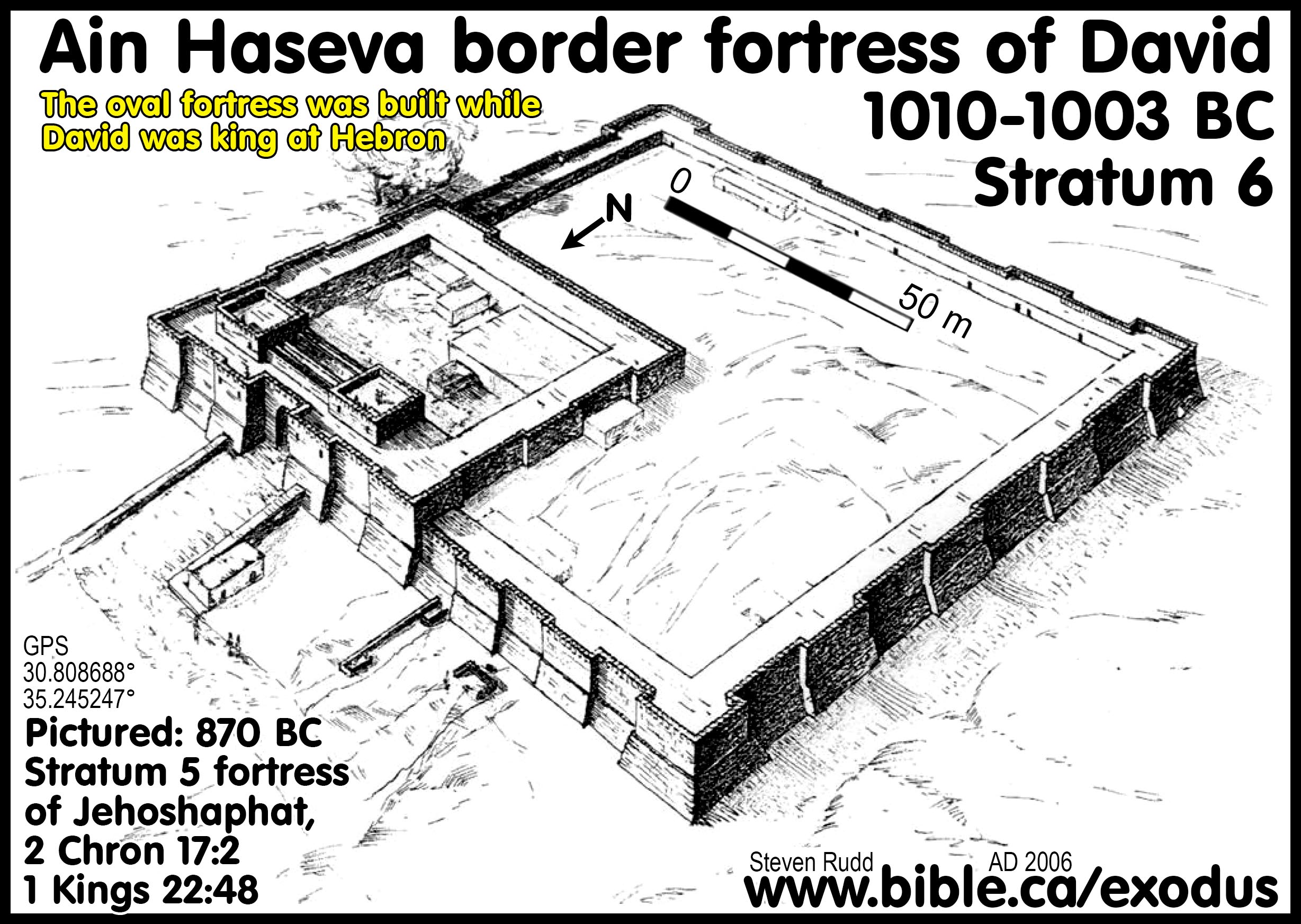
- The fortress at Tell el-Kheleifeh was built on a hill 500 meters from the shore of the Red Sea less than 12 feet above current sea level. This proves sea levels have not changed much in 3000 years. "The Jordanian site of Tell el-Kheleifeh is located approximately 500 m from the northern shore of the Gulf of Aqaba, roughly equidistant between modern Eilat and Aqaba. The western side of the mound, today clearly defined by the excavator's western dump (figs. 1-3), is some 6 m east of the fence that demarcates the neutral zone between Jordan and Israel." (Excavations at Tell el-Kheleifeh: A Reappraisal, Gary D. Pratico, 1985 AD)
- Clear connections have been found between Tell el-kheleifeh and Solomon's copper mines at Timna a 15 miles north, including copper fishhooks and copper slag.
- "Although the Masoretic Text for 2 Kgs 16:6 reads: At that time Rezin king of Syria recovered Elath to Syria ..., it is generally accepted that Rezin is a later addition to the sentence and Aram (Syria) is a misreading of Edom, since Elath, never having belonged to Syria in the first place, could not have been recovered by Syria (Bartlett 1989:127)." (The Iron Age Fortresses at En Haseva, Rudolph Cohen, 1995 AD)
A. Location of Elat and Ezion-Geber:
|
|
|
4. Flinder agrees with us that if there is possibly and undiscovered fortress of Solomon. He is of course wrong in suggesting that Jezirat Faraun is Ezion-geber since, it is located on the Egyptian not Edomite side of the Red Sea: "If Solomonic Eloth is not at Tell el-Kheleifeh, it probably lies buried somewhere beneath the sands of modern Eilat or Aqabah; but the site of Ezion-Geber is surely the island of Jezirat Faraun." (Jezirat Faraun: Is This Solomon's Seaport?, Alexander Flinder, 1989 AD)
5. For the last century everyone has been looking for Ezion-geber in the wrong places. From 1938 - 1965 AD, Glueck misled the world into thinking that tell el-kheleifeh was Ezion-geber. Then in 1965, Glueck stunned the archeological world by rejecting it as Ezion-geber. Today archeologists are looking for Ezion-geber in the wrong place. Ezion-geber was beside Elat, in the land of Edom. That means Ezion-geber is on the east side, not the north side of the gulf of Aqaba. "Thus, in 1965, with Glueck's disclaimer, the identification of the site of Ezion-Geber was once more uncertain. It had to be somewhere in the north of the Gulf of Eilat/Aqabah. But where?" (Jezirat Faraun: Is This Solomon's Seaport?, Alexander Flinder, 1989 AD)
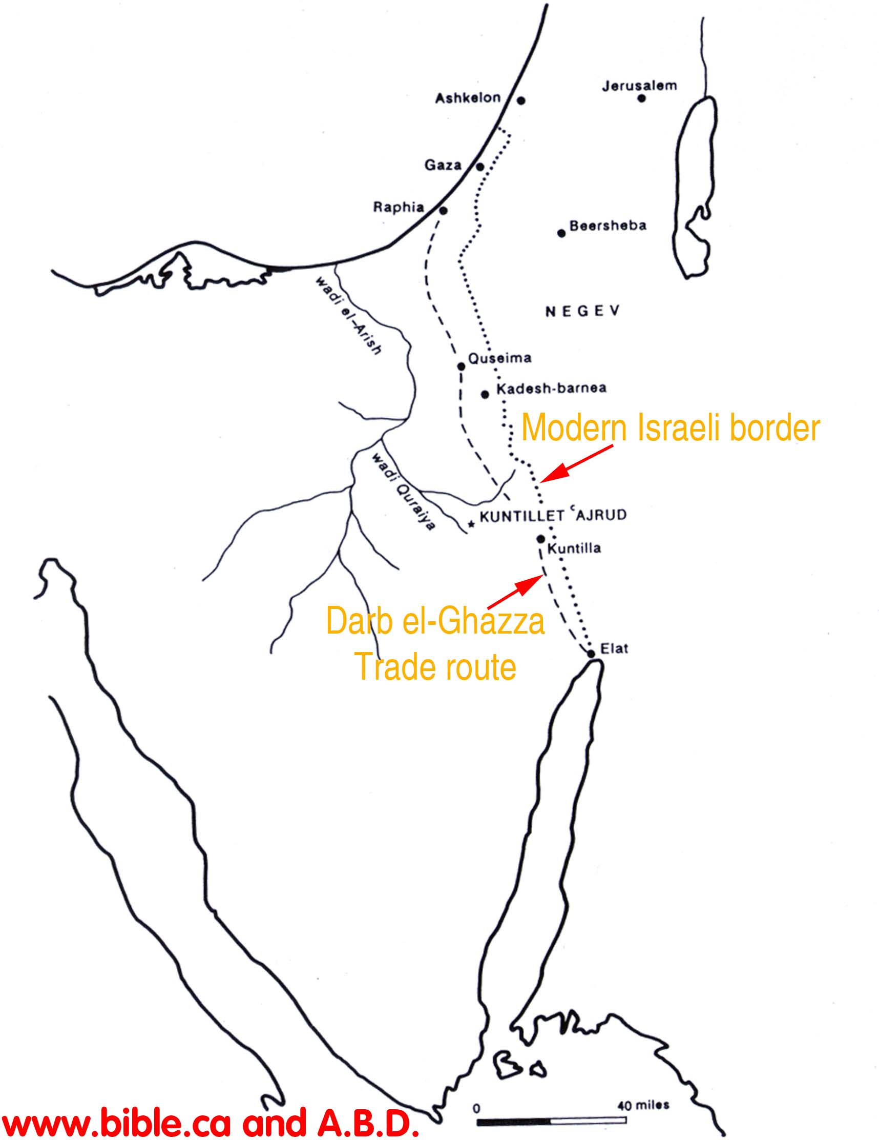
B. The Onomasticon lists Elat:
- view The Onomasticon
- Ailam (Ailath). Is situated at the extremity of Palestine between the southern desert and the Red Sea where cargo was transported by ship from both Egypt and India. A detachment of the Tenth Roman Legion is stationed there. Properly called Aila today (it was formerly pronounced Ailath) from whence the ancient people the Ailamites whose king was Chodollagomor [who is mentioned in the Acts of the Apostles]. Another Ailam of the foreigners (of Palestine) is noted in Kings. Footnote #: 6: Ailam (Ailath). Genesis 14:1; K.6:17; L. 234:75. In the Vulgate we find Ailath, Elath, and Aila for this same site. Palestine is the southern part of Syria. This word is missing in the Vatican Manuscript. Technically the southern limits of the Onomasticon should be Ailam (Ailath). The ruins are inland about one mile from Aqabah but not as far inland as Tell el Kbeleifah which is probably the older Ezion Geber (K. 36:l, cf. K. 34:23, 62:13, Josephus Antiquities, IX, 12, 1). It was the end of the road going north to Damascus and the terminus of the overland road west to the Mediterranean. In Jerome's time it was a very busy port (Vita Hilariaris, 18, and cf. Commentary on Ezekiel 47:18). Eusebius does not indicate its size but it may be inferred that it was a polis. A bishop was present at Nicea. Eusebius uses some army source and the text is useful for noting the deployment of the Roman legion. The Tenth is located here. The Notitia Dignitatum (73:18f.) verifies this entry. The Tabula Peutinger, 820 has a Haila 83 miles from Petra and 150 miles southeast of Gaza which fits this site at el 'aqaba. The city in II Samuel 10:16 is in northeast Transjordan. The Syriac text notes it is a city of the Philistines. The Greek allophulos usually means Philistines but once or twice we cannot be positive, so in this present translation the general term "foreigners" has been preferred, especially when Jerome does not have Filistine. He has Filistine in K. 7:15, K. 21:2, K. 3:25, K. 119:3 but more often uses transliteration allofylorum (see Appendix I).
B. Darb el-Ghazza trade route between Elat and Gaza
C. There was a yoyo of possession between Judah and Edom regarding Ezion Geber and Elat:
- "King Solomon also built a fleet of ships in Ezion-geber, which is near Eloth on the shore of the Red Sea, in the land of Edom." 1 Kings 9:26
- "Then Solomon went to Ezion-geber and to Eloth on the seashore in the land of Edom." 2 Chron 8:17
- Must have been lost because Azariah recaptured it: "All the people of Judah took Azariah, who was sixteen years old, and made him king in the place of his father Amaziah. He built Elath and restored it to Judah after the king slept with his fathers." 2 Kings 14:21-22
- A few years before the Assyrian captivity of 722 BC, the Edomites recaptured Elat again from Edom, after Azariah died: "At that time Rezin king of Aram recovered Elath for Aram, and cleared the Judeans out of Elath entirely; and the Arameans (Edomite) came to Elath and have lived there to this day." 2 Kings 16:6
|
F. Ezion-Geber is a critical key to determining the exodus route: |
|
All routes must run through Ezion Geber. |
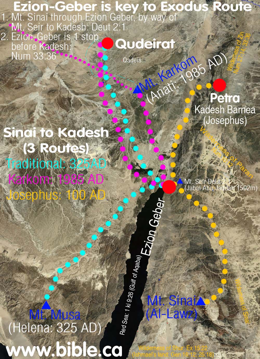
- Israel traveled from Mt. Sinai, THROUGH Ezion-Geber, passing beside Mt. Seir, en route to Kadesh Barnea: Deut 1:2.
- Ezion-Geber is one stop before Kadesh Barnea: Num 33:36 The only route that fits is Lawz to Petra. Josephus said that Kadesh was located at Petra in 110 AD. Although it is 100 km from Ezion-geber, they traveled up the Arabah Valley to get to Kadesh at Petra. Since the Arabah Valley had no towns or outstanding geologic features that the Hebrews took note of, it makes perfect sense for them to not mark any stops in the Arabah itself. We have no doubt that they made several camps as they made the 100 km journey, just that Moses didn't take note of it. The same thing happened in the route from Goshen to the crossing of the Red Sea. Moses noted only one stop between Goshen and the Red Sea: Succoth, even though it is 380 km trip. Therefore we have a precedence for why Ezion-geber could be only one stop from Petra (Kadesh) and yet be a 100 km journey.
- The traditional route from Mt. Sinai (Mt. Musa in the modern Sinai Peninsula) to Kadesh Barnea (Qudeirat) makes little sense, since they would not travel way out of their way, through the mountains to get to Ezion-Geber, then north to Qudeirat. They would not travel east to Ezion-geber, but north from Mt. Musa directly through the easy to travel through desert to Qudeirat.
- The route from Mt. Karkom to Ezion Geber to Qudeirat as impossible as it is illogical, for the simple reason that Ezion-Geber is the midpoint between the two. Emmanuel Anati, suggested and 11 day route between Mt. Karkom and Qudeirat. Click here for a map of his route. Anati also picked a location for Mt. Sier at random to make one part of Deut 2:1 fit. Of course Anati's view must be rejected because it contradicts the Bible, since does not travel through Ezion-Geber at all! Enati's route also travels from Goshen PAST Qudeirat to Karkom, then back to Qudeirat. This also makes no sense.
- Ezion-geber creates huge problems for the other two routes because of the mountain ranges west of Ezion-geber. For Anati's route to work, he would have to make Israel cross the same mountain range twice in the route from Karkom through Ezion-geber and then back again to Qudeirat. The traditional route from Mt. Musa through Ezion-geber, would have to cross the same mountain range. If Mt. Musa really was Mt. Sinai, as Queen Helena "saw in a vision" in 325 AD, then they certainly would never travel through Ezion-geber.
- The only exodus route that can harmonize an 11 day journey from Mt. Sinai through Ezion Geber to Kadesh Barnea is: Mt. Lawz in Saudi Arabia as Sinai and Kadesh near or at Petra. This fits nicely with the exodus route since Ezion Geber is a direct line path between the two.
G. Ezion Geber is only one stop from Kadesh Barnea:
- Ezion-geber is also one stop removed from Kadesh Barnea and Mt Hor. Ezion-geber is within the land of Edom. This is also near the wilderness of Zin. Mt. Hor is on the eastern transjordan mountain range that flank the Arabah Valley.
- "King Solomon also built a fleet of ships in Ezion-geber, which is near Eloth on the shore of the Red Sea, in the land of Edom. " 1 Kings 9:26
- "So we passed beyond our brothers the sons of Esau, who live in Seir, away from the Arabah road, away from Elath and from Ezion-geber. And we turned and passed through by the way of the wilderness of Moab." Deuteronomy 2:8
- "Jehoshaphat made ships of Tarshish to go to Ophir for gold, but they did not go for the ships were broken at Ezion-geber." 1 Kings 22:48
- "They journeyed from Abronah and camped at Ezion-geber. They journeyed from Ezion-geber and camped in the wilderness of Zin, that is, Kadesh. They journeyed from Kadesh and camped at Mount Hor, at the edge of the land of Edom. " Numbers 33:35-37
M. Jezirat Faraun cannot be Ezion-Geber: Egyptian Sea port for Timna.
|
|
Jezirat Faraun is an Egyptian sea port used to transport materials to and from the copper and turquoise mines at Timna. 1406-1200 BC. There was a known trade route between Timna, Elat to Egypt. It is not likely Solomon used this sea port, as it was well inside Egypt. Ezion-Geber is located on the other side of the Gulf of Aqaba, under the modern shipping docks. The same Midianite pottery was discovered here as in Timna, Al-Bad and Qurayyah where they manufactured it. |
- Rothenberg is very wrong for suggesting that Jezirat Fara'un is Ezion-Geber that became Solomon's sea port. Ezion-Geber is in the land of Edom, not Egypt. "Jezirat Fara'un (or 'Pharaoh's Island') appears to have been the mining port connected with the Ramesside mining expeditions to the Arabah ('Atika'). It was later used by the Israelite Kings (as Ezion Geber.), then by Nabateans, Romans and Mamelukes." (Timna, Beno Rothenberg, 1969 AD)
- This island was called variously 'Ile de Graye', 'el Qureiye', 'el Deir', 'el Kasr hadid', `Emrag', and recently the 'Coral Island'. It was first described by E. Riippel in 1829 and has since been repeatedly visited by travellers, geographers and archaeologists who dated the remains on the island as Byzantine, medieval Arabic or Crusader. (Timna, Beno Rothenberg, 1969 AD)
- The most obvious reason why Jezirat Faraun cannot be Ezion-geber, is because it contradicts the Bible which says Ezion-Geber was in the land of Edom. Edom was never anywhere near Jezirat Faraun, but on the opposite shore. Edom was transjordan from the time of the Exodus 1446 BC to the time of the Babylonian captivity. Jezirat Faraun has always been within Egyptian control even before 1446 BC.
- Jezirat Faraun is described as one of the best natural ports on the northern tip of the Gulf of Aqaba. Yet today it is not used as such. There are modern ports in both Elat, Israel and Aqaba, Jordan today that get along just fine weathering storms. We suspect Solomon's port of Ezion-geber, located under the modern sea ports of the Aqaba, Jordan, also weathered various weather conditions as well.
- Jezirat Faraun is a 12-14th century BC, Egyptian Sea port, built by to support the copper mining at Timna. It is very likely that this was one of the many military "watchtowers" Egypt built and were in full function at the time of the exodus of 1446 BC. "Now we must turn to the difficult problem of dating. In the absence of a systematic excavation, the dating of the perimeter wall, as well as the harbor and jetties, must be conjectural. Some scholars have expressed the view that these structures are all Byzantine, but it is not implausible that they belong to earlier periods of occupation. Pottery found on the island by Rothenberg in 1972 and a small quantity collected by us in 1968 has been dated to Iron Age I (1200-930 B.C.) Rothenberg's excavation of the Hathor (Khat-KHOR) Temple at Timmah,16 north of Eilat, has produced evidence of an Egyptian mining operation in the Late Bronze/Early Iron Age I (14th-12th centuries B.C.). From this Rothenberg has concluded that the island was an Egyptian mining harbor of the Ramessid pharaohs. Rothenberg also points to the remains of a small metallurgical installation on the island, as well as a quantity of fayalite stag (an iron-based silicate), evidence of small-scale iron-smelting activities on Jezirat Faraun." (Jezirat Faraun: Is This Solomon's Seaport?, Alexander Flinder, 1989 AD)
- The island of Jezirat Faraun has been an important and strategic island for 3500 years. There are Christian (Crusader) and Muslim (Saledine) forts on the island that are hundreds of years old. "The Moslem caliph Saladin fortified the island in 1170 A.D. The French Crusader Reynald de Chattillon laid siege to the island (which was then called the Isle de Graye) while plundering towns on the Red Sea and raiding pilgrim ships bound for Mecca. In 1217 a Christian pilgrim named Thietmar visited the island and reported that he found it inhabited by both Saracens and Christians, as well as "French, English and Latin slaves who fished here for the profit of the Sudan."11 According to the medieval historian Abufelda, the island was abandoned about 1300 A.D. Except for the occasional garrison of troops during the 400 years of Ottoman rule, the island was apparently never inhabited again." (Jezirat Faraun: Is This Solomon's Seaport?, Alexander Flinder, 1989 AD)
- Nelson Glueck made a number of obvious errors in suggesting Tell el-Kheleifeh was Ezion-geber. Anyone who even considers the island of Jezirat Faraun as Ezion-geber are mistaken. The Bible says that Ezion-Geber was in the land of Edom, not Egypt.
- Jezirat Faraun is not a good choice for reasons admitted even by those who suggest it is Ezion-geber. It is essentially land locked from Israel by a major mountain range except for a narrow shoreline area. Although it may seem odd that Egypt would use this as a port, remember that it was well inside Egyptian territory, away from Edom's control on the opposite shore of the Red Sea. It did have an excellent large beach just eat of the Island which would be very suitable for storage and transport to Egypt by land. The Island itself was not useful for this purpose: "Although Jezirat Faraun would serve well as a port, it was much less suitable for storage and distribution of merchandise. It is likely that the ocean-going ships of the Solomon-Hiram fleet would unload at the island into secure storehouses, but thereafter the merchandise would be transported by smaller craft for the seven and a half mile journey to the head of the gulf, to the terminus of the traditional land routes between Syria, Egypt and Arabia. Thus Ezion-Geber functioned as a port and Eloth as a storage depot and caravanserai. The Biblical account stresses that the two sites were different entities: "Ezion-Geber which is near Eloth" (1 Kings 9:26) and "Solomon went to Ezion-Geber and to Eloth" (2 Chronicles 8:17)". (Jezirat Faraun: Is This Solomon's Seaport)
- "There was also some rough and some decorated pottery which at first seemed chronologically unrelated, but in 1961, after the first Timna survey, it was identified as Early Iron Age I pottery. It was clearly the same Midianite (called at the time `Edomite) and Negev-type ware which had been found in the Timna smelting camps. Some of the sherds, especially fragments of a cooking pot, could also belong to Iron Age II. In the light of these pottery dates proposed at the time, and in detail in Negev, the following working hypothesis on the history of the island was put forward: the earliest remains at the site, which consist of the case-mate wall, the harbour wall and dwellings in Area H, and remains of a landing pier on the mainland opposite, date to the Early Iron Age I prior to the United Monarchy of Israel, with a possible use also in the tenth to eighth centuries BC. All other remains relate to the Nabataean, Byzantine and Mameluke occupation of the island. Furthermore, in view of these dates and the fact that the island is the only natural anchorage in the northern part of the Gulfof Elat-Aqaba, it seemed logical to look here not only for a harbour of the period before David's conquest of the area, but also for the port used by Israel's kings. In other words, it was proposed at the time to identify the island of Jezirat Fara'un with the Biblical harbour of Ezion Geber. With the new evidence from the Timna Temple relating the copper mining activities of the Late Bronze Age-Early Iron Age I to the Ramesside pharaohs, and taking into consideration the Papyrus Harris I report of the existence of a regular shipping route to Atika and its identification with the Arabah mines, we now propose to identify early Jezirat Fara'un as a Pharaonic mining harbour. This Egyptian mining port would later be the obvious anchorage for King Solomon's Tarshish ships as it was the main and probably only safe port of the northern Red Sea during all sub-sequent ancient periods. Since 1967 the expedition has re-investigated the island of Jezirat Fara'un and a large amount of pottery was collected there. These investigations and the finds on the island confirmed once more the dates previously proposed, including the existence of fourteenth to twelfth century BC Negev and Midianite ware." (Timna, Beno Rothenberg, 1969 AD)
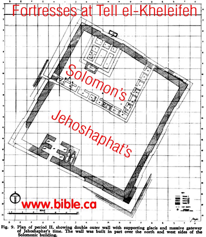
H. Solomon's fortress of Tell el-kheleifeh (Ancient Elat, not Ezion-geber)
"The site can, however, easily be bypassed. Its position is not a commanding one." (Ezion-Geber, Nelson Glueck, Excavations at Tell el-Kheleifeh, 1965 AD)
|
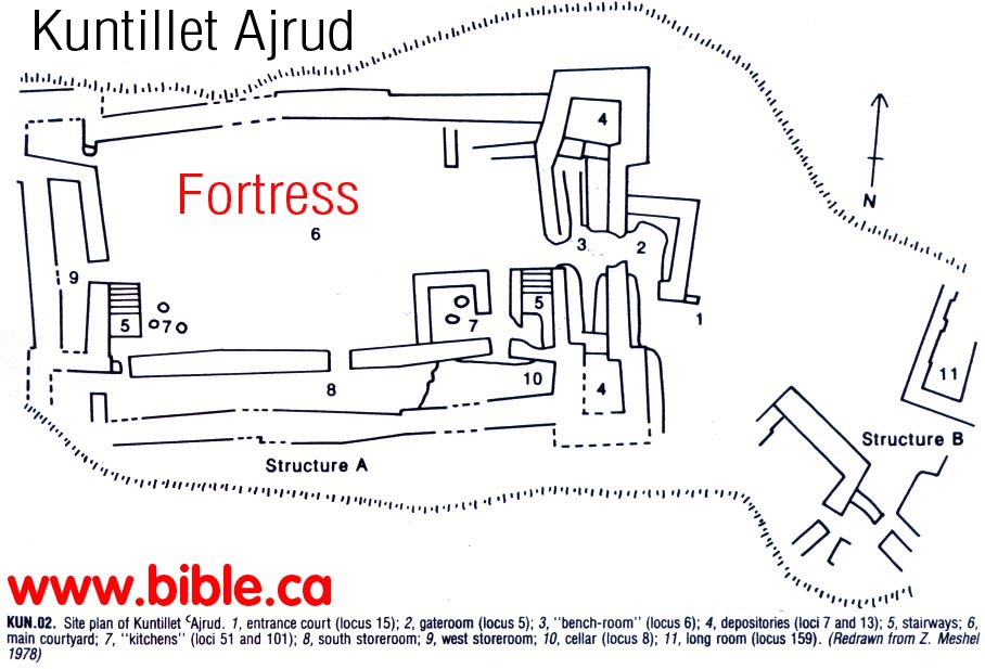
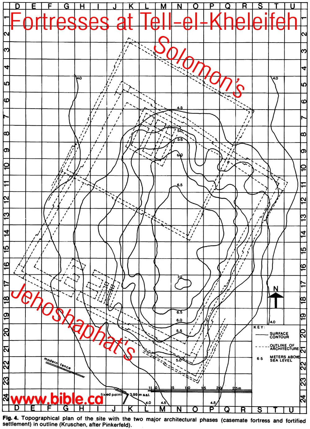
Here is what the fortress that Solomon built at Elat looked like. This is not Ezion-geber as Nelson Glueck speculated in 1938AD but Elat. |
|
|
|
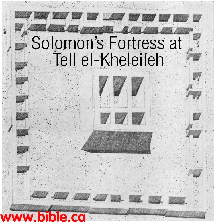
Here is an overlay of Jehoshaphat's fortress over top of the older fortress of Solomon at Elat. |
|
Here is a topographical map that shows of that the fortress was built on a hill 500 meters from the shore of the Red Sea less than 12 feet above current sea level. This proves sea levels have not changed much in 3000 years. |
|
I. Date of the fortress at Tell el-kheleifeh: Time of Solomon
- Cohen (1979: 77-78) dates the wheel made vessels exclusively to the 10th century B.C. and attributes the sites to the time of Solomon, (1979), whereas Meshel dates the pottery to the 1lth to 10th century B.C. and associates the fortresses with "one of the kings who defeated the Edomites and Amalekites" (Meshel and Cohen 1980: 80), either Saul or David. (Excavations at Tell el-Kheleifeh: A Reappraisal, Gary D. Pratico, 1985 AD)
- The Egyptian king Shoshenk, or Shishak, as he is known in the Bible, was in all probability the one who destroyed the Ezion-geber of Solomon? He seems to have been content to gain control of the site, perhaps after breaking down its outer defences. The smelter-refinery and the industrial square of rooms beyond it, remained more or less intact. (The Third Season of Excavation at Tell el-Kheleifeh, Nelson Glueck, 1940 AD)
- Accepting Frank's identification Glueck discerned five major occupational periods, which he dated between the 10th and 5th centuries B.C. ... The data suggest that Tell el-Kheleifeh was occupied in two major phases; casemate fortress and fortified settlement. (Excavations at Tell el-Kheleifeh: A Reappraisal, Gary D. Pratico, 1985 AD)
- Dating the Casemate Fortress: Designating this fortress as Ezion-geber I, Glueck assigned this level to the time of Solomon and its destruction to biblical Shishak (1939: 18; 1940a: 5; 1965: 82). The primary dating tool for the Solomonic level was a pottery horizon, largely unknown at the time, described as "crude, hand-made, friable, smoke-blackened pots, many of which were built up on a mat, and most of which have various simple types of horn or ledge-handles, or combinations of both" (Glueck 1938a: 14). ... The pottery is today known as "Negevite" ware, a tradition with broad chronological limits that embrace the Iron Age at the very least. In light of what is presently known, "Negevite" pottery is not chronologically (or ethnically) diagnostic and must itself be dated by associated wheelmade forms. (Excavations at Tell el-Kheleifeh: A Reappraisal, Gary D. Pratico, 1985 AD)
- "Nothing earlier than Nabataean remains could be found at Aila immediately to the west of Aqabah and nothing earlier than Byzantine and mediaeval Arabic at Aqabah itself." (Ezion-Geber, Nelson Glueck, Excavations at Tell el-Kheleifeh, 1965 AD)
- "Furthermore, a fortress dating from Solomonic times may have existed on top of one of the hills overlooking the site of Aqabah below, with its fertile terrain, crossroads, springs and harbor. Such a fortress may yet be found, and its existence would comport with the general practice of the early Iron age of building fortifications on defensible hilltops dominating strategic points. At the present time, however, the mound of Tell el-Kheleifeh is the only site known on the north shore of the Gulf of Aqabah showing the occupational history necessary for either Ezion-geber or Elath or both. If Tell el-Kheleifeh is not in all finality to be identified with Ezion-geber: Elath, then it must be considered a fortified industrial, maritime, storage and caravanserai center for both." (Ezion-Geber, Nelson Glueck, Excavations at Tell el-Kheleifeh, 1965 AD)
J. Archeological details of Tell el-Kheleifeh:
- The western side of the mound, today clearly defined by the excavator's western dump (figs. 1-3), is some 6 m east of the fence that demarcates the neutral zone between Jordan and Israel. ... Tell el-Kheleifeh is not a conspicuous site today. Its appearance is similar to that of the many surrounding hillocks. ... The mound has been disturbed at several points by modern military installations, most notably an observation tower toward the southern end of Glueck's excavation area. (Excavations at Tell el-Kheleifeh: A Reappraisal, Gary D. Pratico, 1985 AD)
- Shiloh suggests that the monumental four-room buildings, including the Tell el-Kheleifeh structure, functioned as citadels. The conclusion is legitimate if the designation is defined in the context of architecture, that is, a citadel conceived of as a stronghold or fortified place with a view to defense or refuge. The designation should not imply specific military, political, commercial, or domestic functions. The function of each four-room building must be determined, if possible, in light of its own evidence with recognition of the limitations of anepigraphic data. (Excavations at Tell el-Kheleifeh: A Reappraisal, Gary D. Pratico, 1985 AD)
- Tell el-Qudeirat (Kadesh-barnea) and Horvat `Uza. Two other fortified settlements offer instructive parallels for the study of Tell el-Kheleifeh's offsets/ insets phase: Tell el-Qudeirat (middle and latest phases; Cohen 1979: 72-74; 1981: 93-104) and Horvat Uza (Y. Aharoni 1958: 33-35; Cohen 1979: 74-75). Although there are only general similarities in architectural plan, there are pronounced similarities between the handmade and wheelmade pottery horizons of each site, especially between Tell el-Qudeirat and Tell el-Kheleifeh. (Excavations at Tell el-Kheleifeh: A Reappraisal, Gary D. Pratico, 1985 AD)
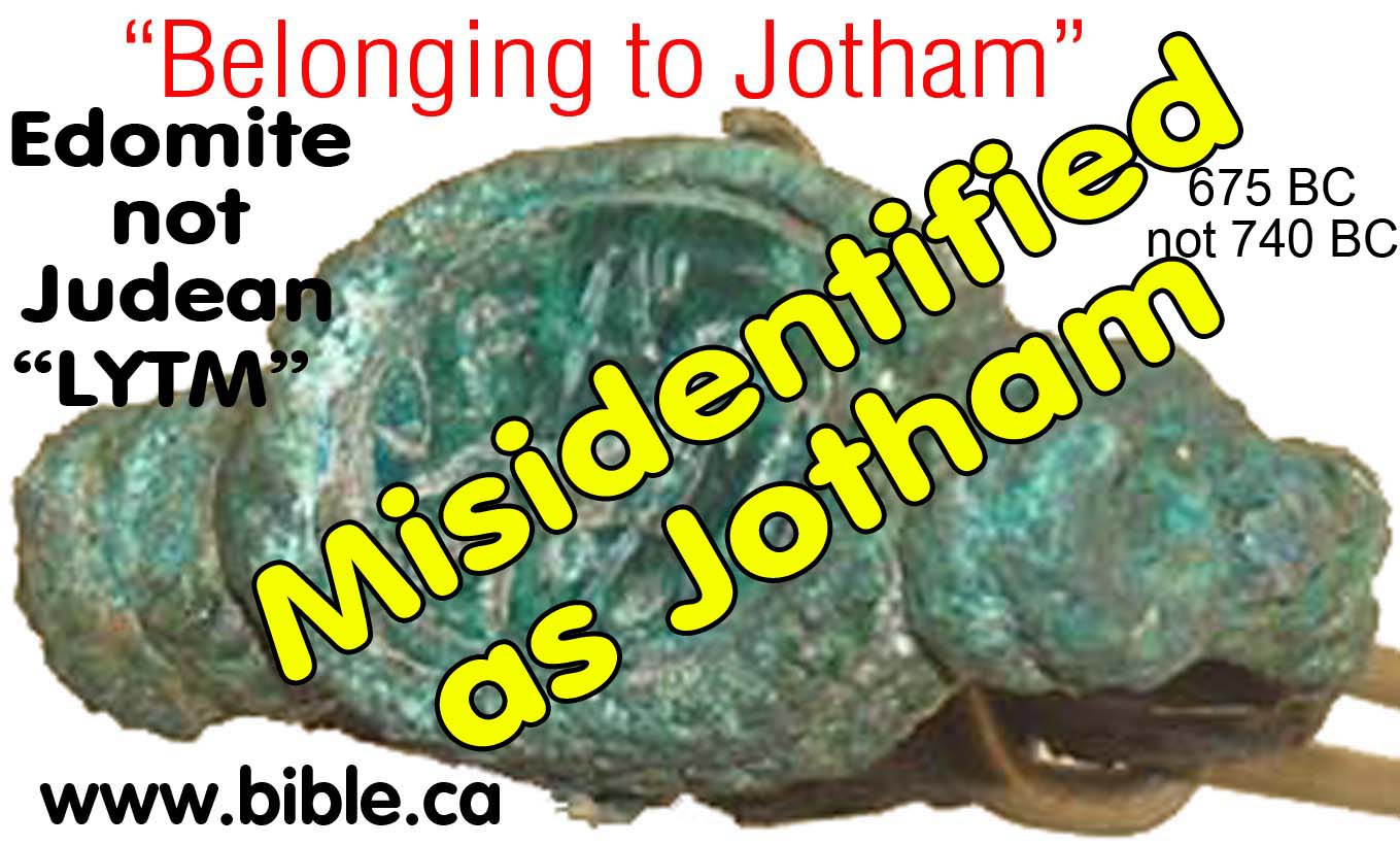
D. The Misidentified Seal signet ring: "Belonging to Jotham" found at El-kheleifeh:
|
The ring is now known to be Edomite not Judean. Also found here was an Edomite inscription reading: "Belonging to Qausanal, the servant of the king" For the Full story of this genuine archeological article that has been misidentified, CLICK HERE |
|
E. El-kheleifeh proves sea levels unchanged in 3000 years:
- We have can use the archeological site of El-kheleifeh which was ancient Elat, (1000 BC) to determine sea levels have really not changed much in 3000 years.
- "The conviction that there has been comparatively little change in the northern shore-line derives partly from our discovery of a copper smelting site on a low shoreline foothill at Mrashrash, now incorporated into Eilat, immediately overlooking the northwest end of the Gulf of Aqabah." (Ezion-Geber, Nelson Glueck, Excavations at Tell el-Kheleifeh, 1965 AD)
- From the topographical map of Tell el-kheleifeh, we can see that the structure is built lower than the 4 meters above sea level only 500 meters from the shore of the Red Sea. This is not ancient Ezion Geber, so it was not built on the shore line, but it is so close and so close to sea level, that we can be quite certain that sea level was not much higher than we see it today.
- Sure the level of the fresh water sea of Galilee and the Dead Sea are much lower today than what they were in the first century, but that is because it hardly rains any more in Israel. Israel was once a natural oasis of plush greenery. That is why it was called the land of Milk (grasslands) and honey (flowers).
- Further, Herodotus said in 450 BC (2500 year ago) that a canal (Suez Canal) needed to be dug between the Mediterranean sea to the Red Sea and it was a four days journey. (Herodotus 2.158)
- This means that the sea level was about as we see it today. This reinforces our view that Pi Hahiroth "mouth of water" was named after a geologic feature that today (and in 1406 BC), looks like a "mouth". However, we still must take erosion into account.
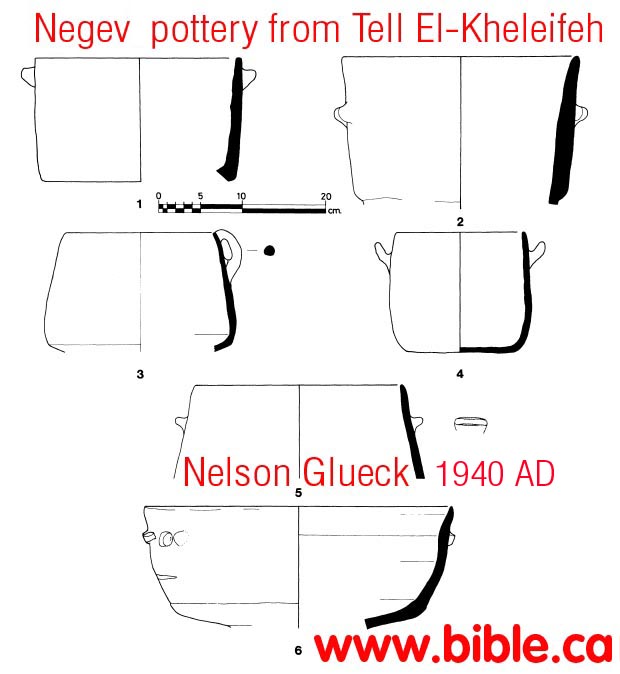
K. "Negev ware pottery found at Tell el-Kheleifeh:
More on Negev Pottery.
- "Tell el-Kheleifeh might still fit the location of Eloth, although no pottery securely datable to the Solomonic period has yet been found there. (Unfortunately, Glueck threw out most of the common wheel-made pottery he excavated; he did not realize this common wheel-made pottery was far more reliable for dating purposes than the handmade pottery he saved.)" (Jezirat Faraun: Is This Solomon's Seaport?, Alexander Flinder, 1989 AD)
- "It should be mentioned in this connection that both on the surface and in the excavations of Tell el-Kheleifeh a coarse, handmade type of pottery was found that at the time was new to us, and that for a brief while appeared to us to be utilized for crucibles. We soon abandoned this idea when it became apparent how common this pottery was on contemporary sites in the Negeb, as well as in the Wadi Arabah and at Tell el-Kheleifeh. Many of these crude, handmade vessels, with which appeared more familiar types of Iron I and early Iron II wheelmade wares, some of which seemed to have regional differences, had mat bases and knob or horn or ledge handles. We believe that this crude, handmade ware was largely the work of Kenites, Rechabites, Calebites, Yerahmeelites and related inhabitants of the Negeb and the Wadi Arabah and is characteristic of much of the pottery of Iron I-II in an area comprising the Negeb, Sinai, the Arabah, and much of Arabia. Tell el-Kheleifeh was obviously a central point of that area." (Ezion-Geber, Nelson Glueck, Excavations at Tell el-Kheleifeh, 1965 AD)
- The pottery of Tell el-Qudeirat offers closer parallels to that of Tell el-Kheleifeh than any other site repertoire as a whole, although the fabrics are notably different. This is especially true for the "Negevite" pottery attested in the three phases at Tell el-Qudeirat (Cohen 1981: 101). The same range of "Negevite" types is attested at both sites. The Tell el-Kheleifeh wares are most closely paralleled, however, by the handmade and wheel-made pottery of Tell el-Qudeirat's middle and latest fortress phases, dated by the excavator between the 8th and early 6th centuries B.C. (Excavations at Tell el-Kheleifeh: A Reappraisal, Gary D. Pratico, 1985 AD)
- Only a handful of "Negevite" straight-walled and "hole-mouth" cooking pots (cf. fig. 12: 1-5) can be associated with the earliest level. (Excavations at Tell el-Kheleifeh: A Reappraisal, Gary D. Pratico, 1985 AD)
- Chronology of the Pottery: Reappraisal of the wheelmade pottery has suggested significant revisions in the site's chronological horizons. While acknowledging the presence of a few forms that can be dated earlier, the pottery must be assigned to the 8th-early 6th century B.C. (Excavations at Tell el-Kheleifeh: A Reappraisal, Gary D. Pratico, 1985 AD)
- The largest pottery horizon in the Tell el-Kheleifeh repertoire is "Negevite" ware, accurately described when first discovered as "fragments of rough hand-made wares, thin-walled, of gritty clay burnt very hard in an open hearth" (Woolley and Lawrence 1914-15: 67). It was first thought by Glueck to be a diagnostic horizon of the 10th century B.C. Recent surveys and excavations have significantly refined the chronology and distribution of this pottery. It is surely attested throughout the Iron Age and perhaps even earlier and later (Rothenberg 1972: 153-54; Cohen 1981: 102). These wares have been found at numerous Iron Age sites, especially the fortresses and fortified settlements of the Negev. They include Horvat Haluqim (Cohen 1976: 34-50), 'Atar Haroca (Cohen 1970: 6-24), Horvat Ritma (Meshel 1977: 110-35), Tell el-Qudeirat (Cohen 1981: 98-103) and numerous lesser known sites (most accessible in Cohen 1979: 75-77). A few "Negevite" vessels have been excavated at the Jordanian site of Buseirah (Bennett 1975: fig. 6:8, 12). (Excavations at Tell el-Kheleifeh: A Reappraisal, Gary D. Pratico, 1985 AD)
- At Tell el-Kheleifeh this handmade pottery is attested in both casemate fortress and fortified settlement levels. There is a fairly wide range of types, although straight-walled and holemouth cooking pots predominate. (Excavations at Tell el-Kheleifeh: A Reappraisal, Gary D. Pratico, 1985 AD)
- The "Negevite" forms that can be assigned to the casemate fortress, provide no refined indication of chronology. The date of this level cannot be determined in light of current data. (Excavations at Tell el-Kheleifeh: A Reappraisal, Gary D. Pratico, 1985 AD)
- Cohen (1979: 77-78) dates the wheelmade vessels exclusively to the 10th century B.C. and attributes the sites to the time of Solomon, (1979), whereas Meshel dates the pottery to the 1lth to 10th century B.C. and associates the fortresses with "one of the kings who defeated the Edomites and Amalekites" (Meshel and Cohen 1980: 80), either Saul or David. (Excavations at Tell el-Kheleifeh: A Reappraisal, Gary D. Pratico, 1985 AD)
L. Tell el-Kheleifeh closely connected with copper smelting:
- In 1940 AD, Glueck misinterpreted round cavities in the walls as furnace flues for smelting copper. In 1965 AD, we correctly understood these to be where support timbers were placed in the wall for structural support. After 2500 years, the wood had disolved leaving round holes in the wall that looked like air ducts for the furnaces. Having said this, there are still clear signs of copper smelting and connections with Timna, just on a much smaller scale than what Glueck originally thought.
- "The location of Tell el-Kheleifeh approximates therefore the description in I Kings 9:26 of Ezion-geber's being located "beside Eloth, on the shore of the Red Sea, in the land of Edom." When we first examined the potsherds, copper slag, bits of copper ore and implements on the surface of Tell el-Kheleifeh, it was seen that the pottery remains dated from the 10th to the 5th-4th centuries B.C. Frank had correctly adjudged them to be older than Roman. Among the surface finds that Frank mentions, in addition to some copper arrow heads, is "an inch high animal figure apparently cast in copper."" (Ezion-Geber, Nelson Glueck, Excavations at Tell el-Kheleifeh, 1965 AD)
- "Copper slag was definitely found in the excavations, as well as remnants of copper implements and vessels. There was, however, little slag compared to the great masses of slag marking numerous Iron I and early Iron II copper mining and smelting sites in the Wadi Arabah, where mining and smelting activities also were carried on in Middle Bronze I" and late Chalcolithic times." (Ezion-Geber, Nelson Glueck, Excavations at Tell el-Kheleifeh, 1965 AD)
- "It should be remembered, however, that cupriferous ores were mined in many places on both sides of the Wadi Arabah, including, for example, more or less level areas in the Wadi Amrani and at Timna (Wadi Mene'iyeh)." (Ezion-Geber, Nelson Glueck, Excavations at Tell el-Kheleifeh, 1965 AD)
- All manner of copper and iron objects were discovered again in the excavations of the third season. They included copper fish-hooks, iron gaff-heads with barbed points, copper arrow-heads and spear-points, fibulae, fragments of fine copper dishes and tools, iron hoes and knives. (The Third Season of Excavation at Tell el-Kheleifeh, Nelson Glueck, 1940 AD)
- Some of the walls of the smelter have stood almost to their original height for nearly thirty centuries.(The Third Season of Excavation at Tell el-Kheleifeh, Nelson Glueck, 1940 AD)
- Allowing for the upward extension of the walls of the smelter above the top of the glacis, it is possible to say that the smelter walls were about twelve feet high. There was no roof over the smelter. The smelter-refinery was literally the center of the first Ezion-geber, or Ezion-geber I, as we shall call it. Some distance removed from it, and around it, was built a square of foundry and factory rooms. This industrial square was only one room thick. (The Third Season of Excavation at Tell el-Kheleifeh, Nelson Glueck, 1940 AD)
By Steve Rudd: Contact the author for comments, input or corrections.
