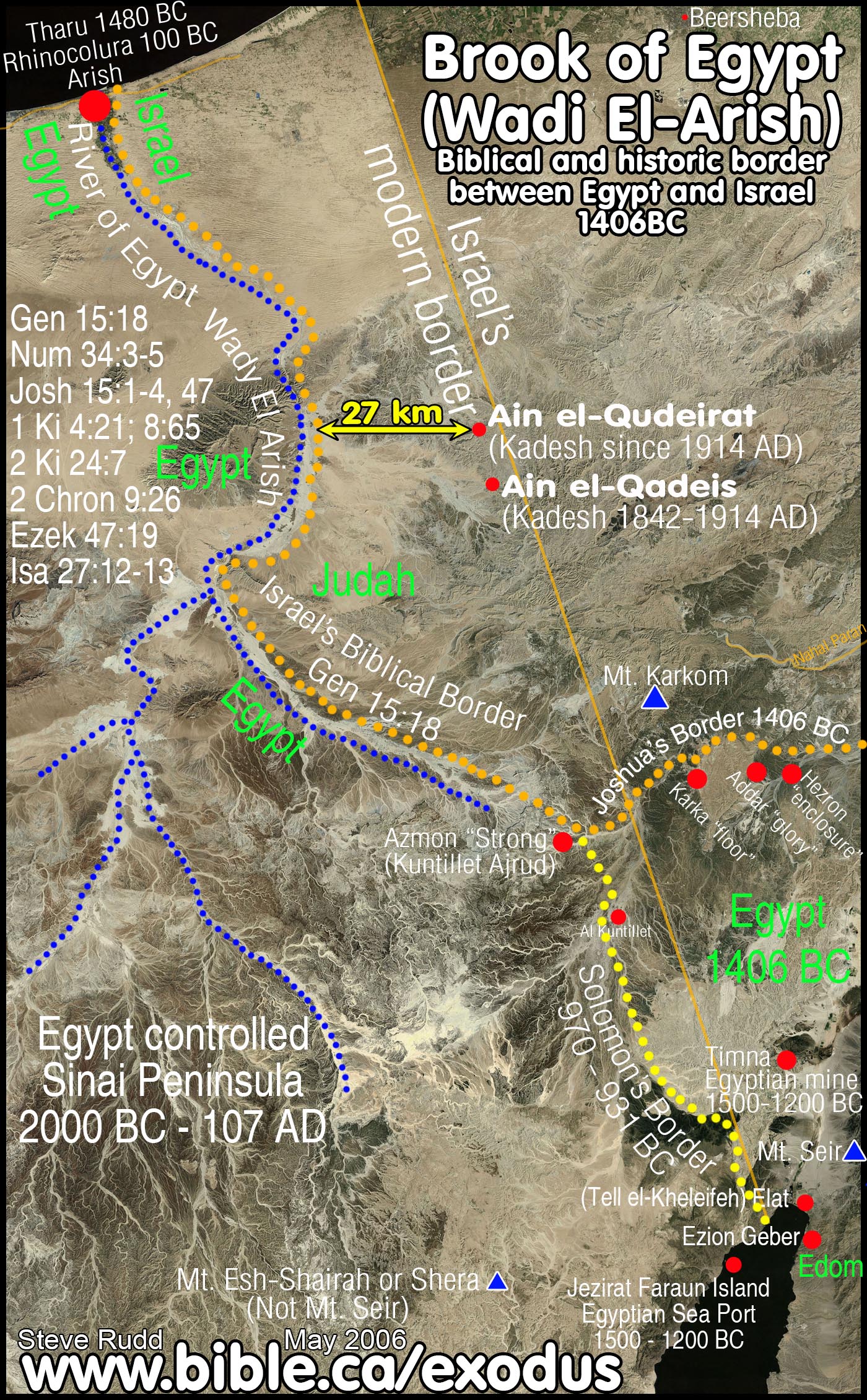
The River of Egypt (Wadi el-Arish)
The Biblical and historic Border
Between Judah and Egypt
|
|
The River: 1. Brook of Egypt 2. River of Egypt 3. Wadi el-Arish 4. Shihor
Egyptian border seaport: 1. Arish 2. Tharu, Tjaru, Tharo, Ṯʾ-rw, (misidentified as Tel Habuwa) 3. Rhinocorura |
Introduction:
- The entire Sinai Peninsula has been under the control of Egypt from before the exodus in 1446 BC down to the time of Christ. The land from the Nile river, the entire modern Sinai Peninsula up to the Wadi el-Arish has been under Egyptian control from the time of Abraham till the Romans annexed the Sinai in 106 AD.
2. The Biblical and historical border between Israel and Egypt has always been the Wadi el-Arish, also known as the River of Egypt. Gen 15:18
- Its called the "River/brook of Egypt" because it was the river that indicated the eastern border of Egyptian Territory. It is not called the "River of Syria" or the "River of Babylon" or the "River of Africa"! River of Egypt means the border river of Egypt. It doesn't get much plainer or simpler than that!
3. The Septuagint substitutes “Rhinocolura” for Brook of Egypt in Isaiah 27:12
a. MT: "In that day the Lord will start His threshing from the flowing stream of the Euphrates to the brook of Egypt, and you will be gathered up one by one, O sons of Israel." (Isaiah 27:12)
b. LXX: "And this will happen on that day: God will fence in the people from the channel of the river as far as the Rhinocolura. But as for you, gather the children of Israel one by one." (Isaiah 27:12)
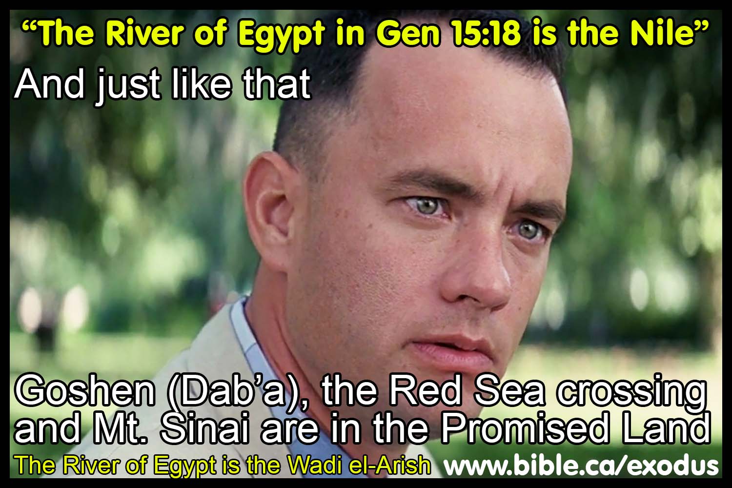
4. The River of Egypt IS NOT the Nile River or the Pelusiac arm of the Nile.
a. If the Gen 15:18 says the Nile was boundary of land God promised Abraham Isaac & Jacob, then: They already lived in the promised land in Goshen while in slavery in Egypt! Exod 3:17 Why leave Goshen? They were home in the promised land making straw bricks!
i. Exod 3:17 "So I said, I will bring you up out of the affliction of Egypt to the land of the Canaanite and the Hittite and the Amorite and the Perizzite and the Hivite and the Jebusite, to a land flowing with milk and honey."'
ii. Exod 33:1 Depart, go up from here, to the land of which I swore to Abraham, Isaac, and Jacob, saying, `To your descendants I will give it.
iii. Deut 6:22-23 'Moreover, the LORD showed great and distressing signs and wonders before our eyes against Egypt, Pharaoh and all his household; and He brought us out from there in order to bring us in, to give us the land which He had sworn to our fathers.'
iv. Deut 11:10 "For the land, into which you are entering to possess it, is not like the land of Egypt from which you came, where you used to sow your seed and water it with your foot like a vegetable garden.
a. Tel
el-Dab’a (Goshen) was on the eastern side of the Pelusiac branch of the Nile,
which made it inside the promised land. So, Israel was already inside the
promised land before they left Goshen! If the Pelusiac arm of the Nile is the
southern border of the promised land in Gen 15:18, then Israel was in the
promised land before they crossed the Red Sea and at Mt. Sinai.
- The Sinai Peninsula is called "The Wilderness of Egypt" The Bible says that there was a long journey through the wilderness BEFORE they reached the Red Sea. (Ezekiel 20:36; Judges 11:16; Exodus 13:18). In 50 AD, Philo of Alexandria understood this and wrote: "a long and desolate journey through the wilderness, destitute of any beaten road, at last arrived at the sea which is called the Red Sea". There is no wilderness west of the bitter lakes or north west of the Gulf of Aqaba, so they must be rejected.
- The fact of Egyptian control of the entire Sinai makes it impossible for Mt. Sinai to be located in the middle of the Sinai Peninsula at Mt. Musa and St. Catharine's Monastery. Mt. Sinai is located at Mt. al-Lawz in north Saudi Arabia.
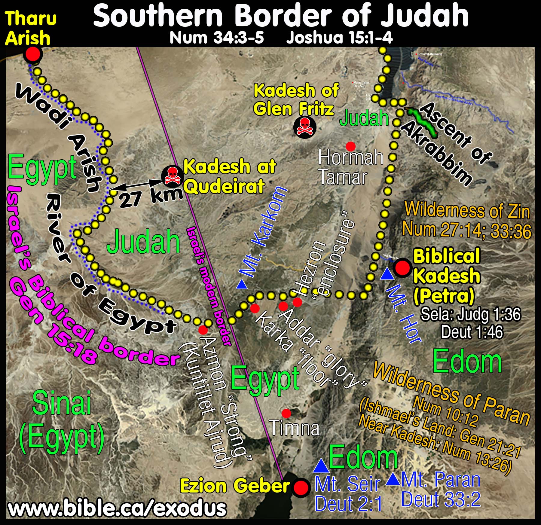
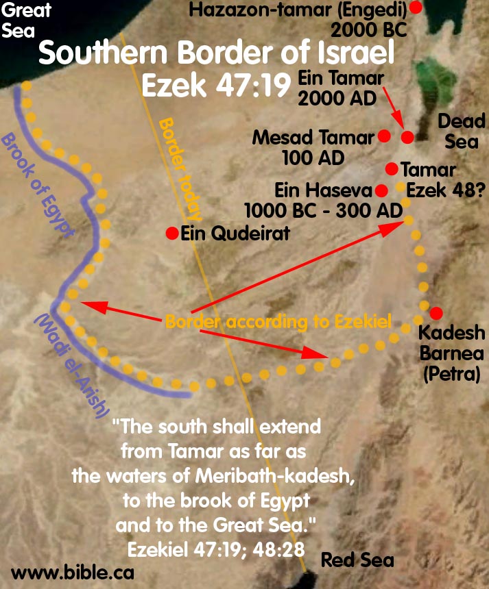
- The location of the southern border of Judah is critically important for determining the exodus route. This is because Kadesh is always mentioned in connection with this southern border. However, the border is completely misinterpreted and drawn incorrectly on almost all bible maps we have seen. Yet the information is right there in the bible and we use scripture to correctly map southern Judah. Only after we have correctly drawn the borders can we know where Kadesh Barnea is located.
- Although there is a single passage that says Judah's border extended down to the Red Sea (Elat/Ezion Geber), this did not happen until the time of Solomon about 950 BC.
- Almost every Bible map since 1916 AD has wrongly located Kadesh Barnea 27 KM inside the land of Judah at Ein El-Qudeirat.
- Kadesh Barnea is located Transjordan, at Petra, just like Josephus said in 110 AD.
- Bible map makers since 1916 AD, begin by placing Kadesh on the map at Qudeirat, then distorted the Biblical borders of Judah accordingly.
- Having chosen the wrong location for Kadesh at Qudeirat,
they also wrongly map the wilderness
of Zin, the Wilderness
of Paran, Mt. Hor,
the border of Edom,
the border of Egypt, and the Ascent
of Akrabbim.
- At the time of the Exodus, Israel was not "out of Egypt" until they crossed the Red Sea at the Straits of Tiran and departed from the modern Sinai Peninsula. Click here for a study of the Sinai Peninsula and the phrase, "out of Egypt" in the Bible. The Bible clearly says that Israel was still in Egypt when they rebelled on the shores of the Red Sea at the Straits of Tiran. "Our fathers in Egypt did not understand Your wonders; They did not remember Your abundant kindnesses, But rebelled by the sea, at the Red Sea. Nevertheless He saved them for the sake of His name, That He might make His power known." Psalm 106:7-8
- The modern border between Israel and Egypt was determined in 1947 AD with UN resolution 181.
- This border is utterly irrelevant to the Biblical border.
- Never in Israel's history has this been the border between Israel and Egypt until 1947 AD.
Part 1: The Biblical border with Egypt is the Brook of Egypt:
A. The Biblical border with Egypt is the Brook of Egypt:
- "On that day the Lord made a covenant with Abram, saying, "To your descendants I have given this land, From the river of Egypt as far as the great river, the river Euphrates:" Genesis 15:18
- 'Your southern sector shall extend from the wilderness of Zin along the side of Edom, and your southern border shall extend from the end of the Salt Sea eastward. 'Then your border shall turn direction from the south to the ascent of Akrabbim and continue to Zin, and its termination shall be to the south of Kadesh-barnea; and it shall reach Hazaraddar and continue to Azmon. 'The border shall turn direction from Azmon to the brook of Egypt, and its termination shall be at the sea. Numbers 34:3-5
- "Now the lot for the tribe of the sons of Judah according to their families reached the border of Edom, southward to the wilderness of Zin at the extreme south. Their south border was from the lower end of the Salt Sea, from the bay that turns to the south. Then it proceeded southward to the ascent of Akrabbim and continued to Zin, then went up by the south of Kadesh-barnea and continued to Hezron, and went up to Addar and turned about to Karka. It continued to Azmon and proceeded to the brook of Egypt, and the border ended at the sea. This shall be your south border. Joshua 15:1-4
- "Ashdod, its towns and its villages; Gaza, its towns and its villages; as far as the brook of Egypt and the Great Sea, even its coastline." Joshua 15:47
- "from the Shihor [wadi el-Arish] which is east of Egypt, even as far as the border of Ekron to the north (it is counted as Canaanite); the five lords of the Philistines: the Gazite, the Ashdodite, the Ashkelonite, the Gittite, the Ekronite; and the Avvite" Joshua 13:3
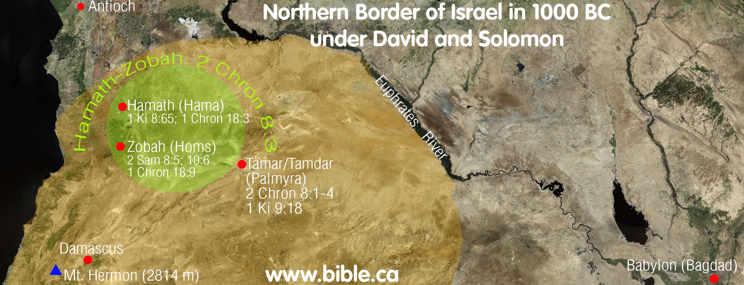
- "Now Solomon ruled over all the kingdoms from the River to the land of the Philistines and to the border of Egypt; they brought tribute and served Solomon all the days of his life." 1 Kings 4:21
- "He was the ruler over all the kings from the Euphrates River even to the land of the Philistines, and as far as the border of Egypt." 2 Chronicles 9:26
- What is also interesting is that the boundaries of
Solomon's kingdom were from Hamath (Near the Euphrates) to the Wadi el
Arish (river of Egypt):
-"So Solomon observed the feast at that time, and all Israel with him, a great assembly from the entrance of Hamath (Near the Euphrates) to the brook of Egypt, before the Lord our God, for seven days and seven more days, even fourteen days." 1 Kings 8:65
-"So David assembled all Israel together, from the Shihor of Egypt even to the entrance of Hamath, to bring the ark of God from Kiriath-jearim." 1 Chronicles 13:5
-"David also defeated Hadadezer king of Zobah as far as Hamath, as he went to establish his rule to the Euphrates River." 1 Chronicles 18:3
- "The south side toward the south shall extend from
Tamar as far as the waters of Meribath-kadesh,
to the brook of Egypt and to
the Great Sea. This is the south side toward the south." Ezekiel
47:19 and "And beside the border of Gad, at the south side toward the
south, the border shall be from Tamar to the waters
of Meribath-kadesh, to the brook of Egypt, to the Great
Sea." Ezekiel 48:28
Full discussion of Ezek 47:19 click here.
- Pharaoh Neco began to occupy Israel and made Eliakim its puppet king. Then Nebuchadnezzar came into Israel and repelled Egypt to the border at the brook of Egypt. This shows that in the 6th century BC, Egypt's traditional border with Israel was the wadi el-Arish, with meant that Egypt controlled the entire modern Sinai Peninsula: "Pharaoh Neco made Eliakim the son of Josiah king in the place of Josiah his father, and changed his name to Jehoiakim. But he took Jehoahaz away and brought him to Egypt, and he died there. " 2 Kings 23:34 "The king of Egypt did not come out of his land again, for the king of Babylon had taken all that belonged to the king of Egypt from the brook of Egypt to the river Euphrates." 2 Kings 24:7
- Isaiah 27:12-13: Mirroring Gen 15:18, here we have a "Hebrew parallelism" that equates Euphrates with land of Assyrian and the brook of Egypt with the land of Egypt. The "wilderness to Lebanon" is equated with Assyria as the Northern border: Deut 11:24; Josh 1:4: "In that day the Lord will start His threshing from the flowing stream of the Euphrates to the brook of Egypt, and you will be gathered up one by one, O sons of Israel. It will come about also in that day that a great trumpet will be blown, and those who were perishing in the land of Assyria and who were scattered in the land of Egypt will come and worship the Lord in the holy mountain at Jerusalem." Isaiah 27:12-13
|
Septuagint substitutes “Rhinocolura” for “Brook of Egypt” in Isaiah 27:12 |
|
|
Masoretic Hebrew Text |
Septuagint Greek Text |
|
MT: "In that day the Lord will start His threshing from the flowing stream of the Euphrates to the brook of Egypt, and you will be gathered up one by one, O sons of Israel." (Isaiah 27:12, MT) |
LXX: "And this will happen on that day: God will fence in the people from the channel of the river as far as the Rhinocolura. But as for you, gather the children of Israel one by one." (Isaiah 27:12, LXX) |
B. Notice the interchangeability between brook of Egypt and border of Egypt!
|
Brook of Egypt |
Border of Egypt |
|
Euphrates to brook of Egypt: Gen 15:18 |
Euphrates to border of Egypt: 2 Chron 9:26 |
|
Solomon ruled to brook of Egypt: 1 Ki 8:65 |
Solomon ruled to border of Egypt: 1 Ki 4:21 |
C. South border: brook of Egypt vs. North border: Euphrates
Was used as the global reference of north/south bounders in the same verse
|
Text |
Northern border |
Southern border |
|
Gen 15:18 |
as the great river, the river Euphrates |
from the river of Egypt |
|
1 Ki 8:65 |
from the entrance of Hamath |
to the brook of Egypt |
|
2 Ki 24:7 |
to the river Euphrates |
from the brook of Egypt |
|
2 Chr 7:8 |
from the entrance of Hamath |
to the brook of Egypt |
|
Isa 27:12 |
from the flowing stream of the Euphrates |
to the brook of Egypt (Rhinocolura in LXX) |
|
2 Chr 9:26 |
from the Euphrates River |
as far as the border of Egypt |
|
1 King 4:21 |
from the River |
to the border of Egypt |
|
Jer 2:18 |
to drink the waters of the Euphrates |
to drink the waters of the Shihor? |
|
Ex 23:31 |
to the River Euphrates |
from the wilderness |
D. The Shihor River is the Wadi el-Arish
- The word "Shihor" seems to be used of the Pelusiac branch of the Nile. Shihor is used interchangeably with the Nile: Isa 23:3 The grain of the Nile, the harvest of the Sihor was her revenue
- Exactly what river the term "Shihor" refers to is not universally agreed. Some think it refers to the easterly "Pelusiac" arm of the Nile. Others think it refers to the Brook/River of Egypt.
- However we can be sure that it does refer to the River/brook of Egypt in several key passages: "So David assembled all Israel together, from the Shihor of Egypt even to the entrance of Hamath, to bring the ark of God from Kiriath-jearim." 1 Chronicles 13:5
- Shihor used interchangeably with Wadi Arish:
|
Shihor used interchangeably with Wadi Arish |
|
|
Josh 13:2-5 |
Josh 15:45-47 |
|
Shihor which is east of Egypt |
as far as the brook of Egypt |
|
Ekron |
Ekron |
|
Ashdodite |
Ashdod |
|
Gazite |
Gaza |
E. The "river of Egypt" in Gen 15:18 cannot be the Nile:
A. Usage of Hebrew word for river in OT: Gen 15:18 uses: Heb "Nahar" (Strongs 5104)
1. Heb "Nahar" (Strongs 5104) of 98 uses and never refers to Nile except in Gen 15:18?
2. Heb: "Ye'or" (Strongs 2975) is used 57 times exclusively of the Nile river.
3. Heb "Nachal" (Strongs 5158) used of both the brook of Egypt and Euphrates in 2 Ki 24:7
|
Term |
Hebrew |
comment |
|
Nile |
Ye'or misrayim |
Egyptian term exclusively used of Nile in Bible |
|
Brook of Egypt |
Nahal misrayim |
Wadi Arish: southern boundary of promised land |
|
River of Egypt (Gen 15:18) |
Nahar misrayim |
If the Nile, why didn't God use the exclusive term "Ye'or" but a one time exception "Nahar"? |
B. Contrasting sizes of rivers indicated textually in Gen 15:18
"from the river of Egypt as far as the great river, the river Euphrates"
1. The text clearly indicates that the Euphrates is greater than the "River of Egypt"
2. The Nile is equal or larger than the Euphrates in size, If the Nile was meant the text would read,
a. from the great river, the river of Egypt as far as the great river, the river Euphrates; or
b. from the two great rivers, the river of Egypt as far as the river Euphrates; or
c. from the river of Egypt as far as the river Euphrates
3. If the Wadi Arish was meant, the text would read exactly as it does!
Part 2: Archaeological and Literary sources on Egypt’s border:
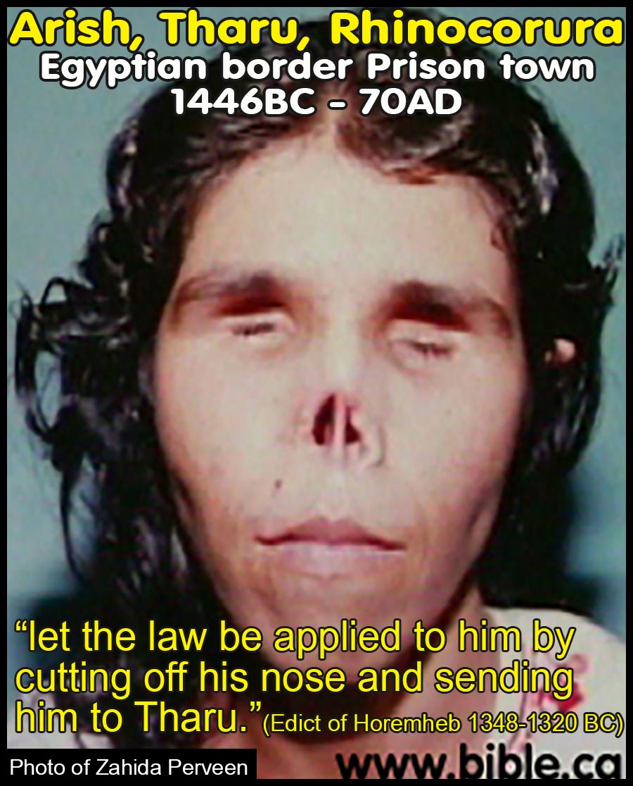
A. Tharu is Arish: Egyptian prison camp on the border between Egypt and Israel.
- Prison camp at Tharu (Tjaru, Tharo, Ṯʾ-rw, Greek: Sile):
- Tharu is the location of the Egyptian prison at ancient border of Egypt and was the name used for the city of "Arish" by the Egyptians in 1446-1200 BC.
- The Egyptians would cut off the noses of their criminals
and ship them to the furthermost part of Egypt at Tharu. Recently in the
news, Zahida's Muslim husband cut off her ears, tongue, and nose, gouged
out her eyes, and left her for dead. This is what all the convicts at
Tharu (Tjaru) looked like. Thanks to your friendly neighborhood Muslim,
we can see today what the Egyptians did in 1480 BC. Tharu was an Egyptian
prison town later known as or Rhinocorura by the Greeks. Rhinocorura
literally means, "cut-off noses."
- Tel Habuwa [Tell el-Habua, Tell-Huba]: Tharu/Tjaru/Tharo has been misidentified as being located at Tel Habuwa.
- This site is located two miles east of the Suez Canal.
- While excavations at Tel Habuwa beginning in 1988 have uncovered evidence of the Hyksos, Thutmoses III and Seti I, including tombs, administration buildings and food storage facilities, there is no evidence of the famous prison located there for over 1500 years.
- Tel Habuwa was first misidentified as Tharo/Tharu by Mohamed Abdel Maqsoud, the director of excavations in 2015.
- A report in volume 56 of Egyptian Archaeology provides zero direct evidence to connect Tel Habua with Tharu. (Tel Habuaː new discoveries from the Saite Period, Sayed Abd el-Alim, Egyptian Archaeology 56, p10-11, 25th March 2020 AD)
- Archeologists often suggest name associations for sites that are speculative and uncertain. For example, the author has participated in excavations that finally marked the second conquest city of Ai at Kh. el-Maqatir. Previous sites had been suggested as Ai at Kh. Nysia and Et Tel. The consensus view that Et Tel was Ai of Joshua continues to prevail in spite of new excavations at Kh. El-Maqatir proving otherwise. The same is true when archeologists confidently announce that Tel Habuwa is the prison border town of Tharu. It is important to look at all the evidence and make sure a proposed site meets all the known identification criteria. These archeologists have not discussed the many literary sources that associate Tharo/Tharu with Arish and Rhinocorura.
- Tel Habuwa is an important archaeological site from the time of Moses but nothing has been excavated and documented that specifically identifies it as Tharu.
- 1463 BC: Thutmoses III and the Battle of Megiddo:
- This account of the Thutmoses III’s Battle of Megiddo
- Thutmoses III’s full name was “Menkheperre Thutmoses III”
- The Battle of Megiddo began Starting in the 22nd regnal year (1463 BC - Low Chronology) of Thutmoses III.
- Thutmoses III is the pharaoh of the Exodus who in Regnal year 22 (1463 BC) began his first campaign after the death of his co-regent stepmother Hatshepsut.
- Thutmoses III was Pharaoh in 1446 BC for a total of 54 years. (1485-1431). But there were three distinct phases to his rule.
- 1485-1464: Regnal years 0-21: First was when he was a baby and his stepmother Hatshepsut ruled as co-regent for 21 years.
- 1464-1446: Regnal years 21-39: Second, after Hatshepsut died he ruled as Pharaoh for 18 years until the exodus in 1446 BC.
- 1446-1431: Regnal years 39-54 Third, he ruled another 15 years after the exodus.
- "Year 22 [1463 BC -Steve Rudd], fourth month of the second season, on the twenty-fifth day his majesty was in Tharu on the first victorious expedition to extend the boundaries of Egypt with might. Now, at that period the Asiatics had fallen into disagreement, each man fighting against his neighbor. Now, it happened that the tribes - the people, who were there in the city of Sharuhen; behold, from Yeraza to the marshes of the earth, they had begun to revolt against his majesty. Year 23, first month of the third season, on the fourth day, the day of the feast of the king's coronation, he arrived at the city, the possession of the ruler, Gaza." (An Egyptian Account of The Battle of Megiddo by Pharaoh Menkheperre, Thutmoses III, 1462 BC)
- 1328 BC: The Great Edict Stela of Horemheb: Tharu was an Egyptian jail where inmates had their noses cut off
- Horemheb succeeded Ay and was pharaoh of Egypt 1328-1300 BC, low chronology as per Kenneth Kitchen.
- Horemheb’s reforms as reflected in his Edict Stela would date to beginning of his reign in 1328 BC.
- This stela was erected by Horemheb at the foot of his own “Tenth Pylon” at Karnak.
- The conclusion of the Coronation Inscription and the Karnak Edict of Horemheb describe the king’s efforts to restore Egypt after the chaos (real and perceived) of Akhenaten’s reign; the usurpation of Tutankhamen’s Restoration Stela may be part of this program as well. The ideology of restoration is further embedded in Horemheb’s Horus name “Victorious Bull, who is clever of plans”. Horemheb’s plans for the restoration of Egypt are detailed in the Karnak Edict and included the eradication of corrupt practices by civil and military authorities.” (Transition 18th - 19th Dynasty, Colleen Manassa Darnell, UCLA Encyclopedia of Egyptology, p4, 2015 AD)
- "my majesty commands: that every officer who seizes the dues] and taketh the craft of any citizen of the army or of any person who is in the whole land, the law shall be executed against him, in that his nose shall be cut off, and he shall be sent to Tharu. (James Henry Breasted, Ancient Records of Egypt, 1906 AD, Vol 3 p 50-67, The Great Edict of Horemheb, 1300 BC)
- Against Requisitioning Boats Used for State Corvee Duty: "If a private individual makes for himself a boat with its on-board shelter, in order to be able to serve Pharaoh, l.p.h., and if people] of the army [come and appropriate it as if it were for (?)] taxes: then the individual is despoiled of his property and deprived of his abundant means [of doing service. This is a crime!] Something like this should not be done [to controvert] his good purposes. As for every boat which is taxable for the offering halls of Pharaoh, l.p.h., by the two deputies [of the army] …, [if someone comes] and seizes a boat belonging to any member of the army or anybody in the entire land, let the law be applied to him by cutting off his nose and sending him to Tcharu {Tharu}. [As for] an individual who is without a boat, and he gets from someone else a boat for his service obligation, and undertakes on his own to bring wood and is thus fulfilling his obligations [to Pharaoh, l.p.h., …]: [should others] seize and plunder his cargo, and steal it, and the individual stands despoiled of his [means of doing service … so that] he has nothing—This is not good, this report: it is an abuse indeed! My Person had decreed that one should turn away from it. Indeed, [this applies to …, and to] those who contribute to the Private Quarters, and similarly to all the gods’ offerings when they are taxed by the two deputies of the army and …: [if anyone does this, let] the law [be applied] against him by cutting off his nose and sending him to Tcharu {Tharu}." (Horemheld’s great edict, 108. Edict from Karnak, Texts from the Amarna Period in Egypt (Vol. 5). W. J. Murnane, , E. S. Meltz, p235, 1995 AD)
5. c. 1300 BC: Relief of Menmaatre Seti I: Fortress at Tharu (Greek- sile) is on Egyptian border
a. Menmaatre Seti I was the father of Ramesses I.
b. This information comes from a pictographic relief scene: “This scene gives Seti’s return from a campaign, but the text states the reasons for his activity. The restlessness in Palestine was an aftermath of the disturbances in the Amarna period. … Somewhere in Palestine Seti I attacked a fortified place, “the town of the Canaan,” which we cannot locate. As the accompanying text indicates, this was on the same expedition as that of the scenes just mentioned.” (ANET 254)
c. “Year 1 of the King of Upper and Lower Egypt: Men-maat-Re. The desolation which the mighty arm of Pharaoh—life, prosperity, health!—made among the foe belonging to the Shasu from the fortress of Sile [Greek version of Tharu] to the Canaan. His majesty [pre]vailed over them like a fierce lion. They were made into corpses throughout their valleys, stretched out in their (own) blood, like that which has never been.” (Relief of Menmaatre Seti I. ANET 254)
6. 1273 BC: Second Campaign of Ramesses II in the Battle of Kadesh: Tharu is at the border of Egypt
a. Three sources for the Battle of Kadesh: (1) the so-called “Poem of Pentaur” (referred to above as “Poem”); (2) the Official Record (called “Record”); (3) the Reliefs. The bibliography, etc., will be found with the introduction to each document. In general, see my Battle of Kadesh, “Decennial Publications of the University of Chicago,” V, 81–127.
b. “This battle, in which Ramses meets the Hittites for the first time, forms the culmination of Ramses II’s second Syrian campaign, and furnishes nearly all we know of the beginning of his Syrian war. It is of especial interest, being the first battle in history of which we may follow the tactics and the disposition of both armies. About the end of April, Ramses marched northward from the fortress of Tharu on the Egyptian frontier, with an army of probably about 20,000 men, in four divisions: the division of Amon, which formed the advance, under the immediate command of the Pharaoh; and the divisions of Re, of Ptah, and of Sutekh, which followed that of Amon in the order given. Marching through Palestine,b and along the Phœnician coast road, Ramses passed into Amor, where he formed his van of picked men, on the “shore in the land of Amor” (Poem, l. 18). Thereupon he left the coast, perhaps marching up the valley of the Litâny, and reached the last elevation on the east side of the Orontes, where the high valley (the Bukâʿa) drops to the level of the plain around Kadesh, about a day’s march south of it. Here he camped (Poem, ll. 11, 12; Record, l. 2), without finding trace of the enemy. He therefore pushed on the next day, and as he reached the ford just south of Shabtuna, later Ribleh, a small town, some seven and a half miles south of Kadesh, he was informed by two Shasu-Bedwin, sent out by the Hittite king for this purpose, that the Asiatics had retreated far northward to the district of Aleppo, beyond Tunip (Record, ll. 2–6). With the division of Amon, therefore, Ramses crossed to the west side of the Orontes at Shabtuna (Poem, l. 12), leaving the other three divisions on the east side, distributed along the road to the south. The division of Re, however, soon crossed at the same ford, with about a mile and a half between its van and the rear of the division of Amon. With these two divisions following him in a long line, Ramses continued rapidly northward, leaving the other two (Ptah and Sutekh) marching slowly south of Shabtuna, till there was a wide gap between the two halves of his army.” (Ancient Records of Egypt, James Breasted, 3.298, p125, 1906 AD)
c. In 1273 AD, Ramses II marched by the fortress of Tharu in full splendor of his father Montu en route to begin the battle of Kadesh against the Hittites. Tharu, at this time, was an Egyptian fort and historically it was the border of Egypt. It proves that Egypt had control right up to the Wadi el-Arish.
d. "Behold, his majesty prepared his infantry and his chariotry, the Sherden of the captivity of his majesty from the victories of his word - they gave the plan of battle. His majesty proceeded northward, his infantry and his chariotry being with him. He began the goodly way to march. Year 5, the second month of the third season tenth month, on the ninth day, his majesty passed the fortress of Tharu, like Montu [his father] when he goes forth. Every country trembled before him, fear was in their hearts; all the rebels came bowing down for fear of the fame of his majesty, when his army came upon the narrow road, being like one who is upon the highway." (James Henry Breasted, Ancient Records of Egypt, 1906 AD, Vol 3 p 136-147, The Battle of Kadesh, Ramses II, 1273 BC)
e. Poem of Pentaur on the Battle of Kadesh: “This poem, long called the “Poem of Pentaur,” is our most important document for a study of the battle of Kadesh. It is, fortunately for us, introduced by a sober and careful prose account of Ramses’ departure from Egypt, his march to Kadesh, and the position of his four divisions up to the moment of the Asiatic attack. Supplemented by the official record of the battle (§§ 316 ff.), we are able to trace in it all Ramses’ movements, immediately before and leading up to the battle. The discussion of the poem as a literary composition does not fall within the scope of this volume.” (Ancient Records of Egypt, James Breasted, 3.305, p135, 1906 AD)
f. Poem of Pentaur on the Battle of Kadesh: “Behold, his majesty prepared his infantry and his chariotry, the Sherden (Šʾ-rʾ-dy-nʾ) of the captivity of his majesty from the victories of his sword ⌜— —⌝ 9———a they gave the plan of battle. His majesty proceeded northward, his infantry and his chariotry being with him. He beganc the goodly way, to march. Year 5, the second month of the third season (tenth month), on the ninth day, his majesty passed the fortress of Tharu (Ṯʾ-rw) 10———e [like] Montu when he goes forth. Every country trembled before him, [⌜fear⌝] was in their hearts; all the ⌜rebels⌝ came bowing down for fear of the fame of his majesty, when his [army] came 11upon the ⌜narrow⌝ road, being like one who is upon the highway of —.” (Ancient Records of Egypt, James Breasted, 3.307, p136, 1906 AD)
7. c. 1250 BC: Year 4000 Stela at Tanis: “Fortress at Tharu”
a. This monument was erected at Tanis by an important official of Ramses II, named Seti. He had been dispatched thither to erect a stela in honor of Seti I, and improved the opportunity to place a stela of his own, bearing a record of his visit in the temple, to which he appended prayers for the favor of the god, as so many officials did in Abydos. Although headed with the full titulary of Ramses II, the document is dated in the four hundredth year of King Opehtiset-Nubti, a Hyksos ruler. This remarkable fact shows that the reign of this king began an era—the only one known in Egypt—which had survived in use at Tanis into the Ramessid times. Unfortunately, the stela does not give the year of Ramses II in which it was erected. Wiedemann dates it, as it seems to me with probability, at Ramses II’s death. In any case, the knowledge of the lapse of 400 years between the Hyksos Nubti and some year of Ramses II is of great value. (Ancient Records of Egypt, James Breasted, 3.538, p288, 1906 AD)
b. “In the year 400, in the fourth month of the third season, on the fourth day, of the King of Upper and Lower Egypt: Opehtiset (ʿʾ-pḥty-St); Son of Re, his beloved: Nubti, whom Harakhte desires to be forever and ever; came the hereditary prince, governor of the (residence) city, vizier, fan-bearer on the right of the king, chief of bowmen, governor of foreign countries, commandant of the fortress of Tharu (Ṯʾ-rw), chief of the foreign gendarmes, king’s-scribe, master of horse, chief priest of the Ram-god, lord of Mendes, High Priest of Set, ritual priest of Buto-Upet-Towe, chief of prophets of all gods, Seti, triumphant, son of the hereditary prince, governor of the (residence) city, vizier, chief of bowmen, governor of foreign countries, commandant of the fortress of Tharu (Ṯʾ-rw), king’s-scribe, master of horse, Peramses, triumphant; born of the lady (nb˙t-pr), the musician of Re (Pʾ-Rʿ), Teya (Ty-ʾ), triumphant. He said: “Hail to thee, O Set, son of Nut, great in strength in the barque of millions of years, ⌜overthrowing enemies⌝ in front of the barque of Re, great in terror, ——— [grant m]e a happy life following thy ka, while I remain in ———.” (Ancient Records of Egypt, James Breasted, 3.542, p288, 1906 AD)
8. c. 1210 BC: Daybook of a Frontier Official: “Fortress at Tharu”
a. “On the blank backs of a few pages of a school copy book an official in some town on the Palestinian frontier, in the days of Merneptah, has noted for temporary reference the names and the business of the messengers who passed through the place on their way to Syria. In addition to the important and interesting glimpse of the active intercourse between Egypt and Syria in the thirteenth century B. C., which the document affords us, it is of importance also as showing that Merneptah in his third year was in Syria, undoubtedly on the campaign during which he plundered Israel, as related in his Hymn of Victory of the year 5 (§ 617). The notes are of the most hurried character, and so abbreviated that the prepositions are omitted.” (Ancient Records of Egypt, James Breasted, 3.629, p270, 1906 AD)
b. “Seventeenth Day: Year 3, first month of the third season (ninth month), seventeenth day: 4There arrived the captains of the archers of the Well of Merneptah-Hotephirma, L. P. H., 5which is (on) the highland, to ⌜report⌝ in the fortress which is in Tharu (Ṯʾ-rw).” (Ancient Records of Egypt, James Breasted, 3.631, p270, 1906 AD)
B. Ancient Tharu and Rhinocorura are the same city as modern Arish:
- Rhinocorura:
- Around 550 BC, Actisanes, king of Ethiopia at the time of Amasis II, renamed the Egyptian border town of Tharu to Greek Rhinocorura
- Rhinocorura is the Greek word for “nose cut off”
- Rhinocorura is el-Arish, where Gen 15:18 says the River of Egypt is Israel's southern border. The word Rhino means "nose". A cow with a long nose is called a “Rhinoceros” meaning “nose-horned”
- Actisanes didn’t found the city of Rhinocorura, as Diodorus Siculus suggests, because Tharu for 1000 years earlier send prisoners there with their noses cut off.
- Rhinocorura was the Greek name for the modern city of "Arish" at the time of Christ.
- 50 BC: Diodorus Siculus said that in 550 BC Actisanes [king of Ethiopia at the time of Amasis II] renamed Tharu Rhinocorura: “After this king a long line of successors on the throne accomplished no deed worth recording. But Amasis [Amasis II 570-526 BC], who became king many generations later, ruled the masses of the people with great harshness; many he punished unjustly, great numbers he deprived of their possessions, and towards all his conduct was without exception contemptuous and arrogant. 2 Now for a time his victims bore up under this, being unable in any way to protect themselves against those of greater power; but when Actisanes, the king of the Ethiopians, led an army against Amasis, their hatred seized the opportunity and most of the Egyptians revolted. 3 As a consequence, since he was easily overcome, Egypt fell under the rule of the Ethiopians. But Actisanes [king of Ethiopia at the time of Amasis II] carried his good fortune as a man should and conducted himself in a kindly manner towards his subjects. 4 For instance, he had his own manner of dealing with thieves, neither putting to death such as were liable to that punishment, nor letting them go with no punishment at all; 5 for after he had gathered together out of the whole land those who were charged with some crime and had held a thoroughly fair examination of their cases, he took all who had been judged guilty, and, cutting off their noses, settled them in a colony on the edge of the desert, founding the city which was called Rhinocolura after the lot of its inhabitants. 6 This city, which lies on the border between Egypt and Syria not far from the sea-coast, is wanting in practically everything which is necessary for man's existence; 7 for it is surrounded by land which is full of brine, while within the walls there is but a small supply of water from wells, and this is impure and very bitter to the taste. 8 But he settled them in this country in order that, in case they continued to practice their original manner of life, they might not prey upon innocent people, and also that they might not pass unrecognized as they mingled with the rest of mankind. 9 And yet, despite the fact that they had been cast out into a desert country which lacked practically every useful thing, they contrived a way of living appropriate to the dearth about them, since nature forced them to devise every possible means to combat their destitution. 10 For instance, by cutting down reeds in the neighbourhood and splitting them, they made long nets, which they set up along the beach for a distance of many stades and hunted quails; for these are driven in large coveys from the open sea, and in hunting them they caught a sufficient number to provide themselves with food.”’ (Diodorus Siculus, Bibliotheca historica, Book 1, 60:1-10, 50 BC)
- AD 15: Strabo confirms that Rhinocorura is the same Egyptian border town as Tharu in 1450 BC: "After Gaza one comes to Rhaphia, where a battle was fought between Ptolemaeus the Fourth and Antiochus the Great. Then to Rhinocorura, so called from the people with mutilated noses that had been settled there in early times; for some Ethiopian [Actisanes king of Ethiopia at the time of Amasis II] invaded Egypt and, instead of killing the wrongdoers, cut off their noses and settled them at that place, assuming that on account of their disgraceful faces they would no longer dare to do people wrong. Now the whole of this country from Gaza is barren and sandy, but still more so is the country that lies next above it, which contains Lake Sirbonis, a lake which lies approximately parallel to the sea and, in the interval, leaves a short passage as far as the Ecregma, as it is called; the lake is about two hundred stadia in length and its maximum breadth is about sixty stadia; but the Ecregma his become filled up with earth. Then follows another continuous tract of this kind as far as Casius; and then one comes to Pelusium." (Strabo, Geographia, XVI,2,31-32)
- “Rhinocorura (or Rhinocolura, as it is sometimes called) is the true equivalent in Isa. 27:12 for the נחל מצרים, or “river of Egypt,” usually called the boundary torrent between Palestine and Egypt. It is now called the Wâdi el ‘Arish. There is also a town of this name, and a curious story is told of the origin of the name by Diodorus Siculus (i, 60). All the suspected thieves in Egypt when Actisanes, king of Ethiopia, conquered it, were collected and had their noses cut off and were then planted in this place; hence the name.” (The Geography of the Septuagint, Henry A. Redpath, American Journal of Theology, Volume VII, p302, 1903 AD)
- “Similar in ingenuity, though not in strength, were the nets made by the convicts banished to Rhinocolura by Actisanes, which, though made of split straws, were yet capable of catching many of the numerous quails that frequented that desert region at a particular period of the year.” (A Popular Account of the Ancient Egyptians, J. Gardner Wilkinson, Vol2, p182, 1890 AD)
- Arish: Arish is the modern seaport city at the mouth of the Wadi el-Arish.
- Wadi el-Arish means: "River of Arish".
- A wadi dries up for part of the year and only flows water during the rainy season.
- Arish is the same location as Tharu and Rhinocorura.
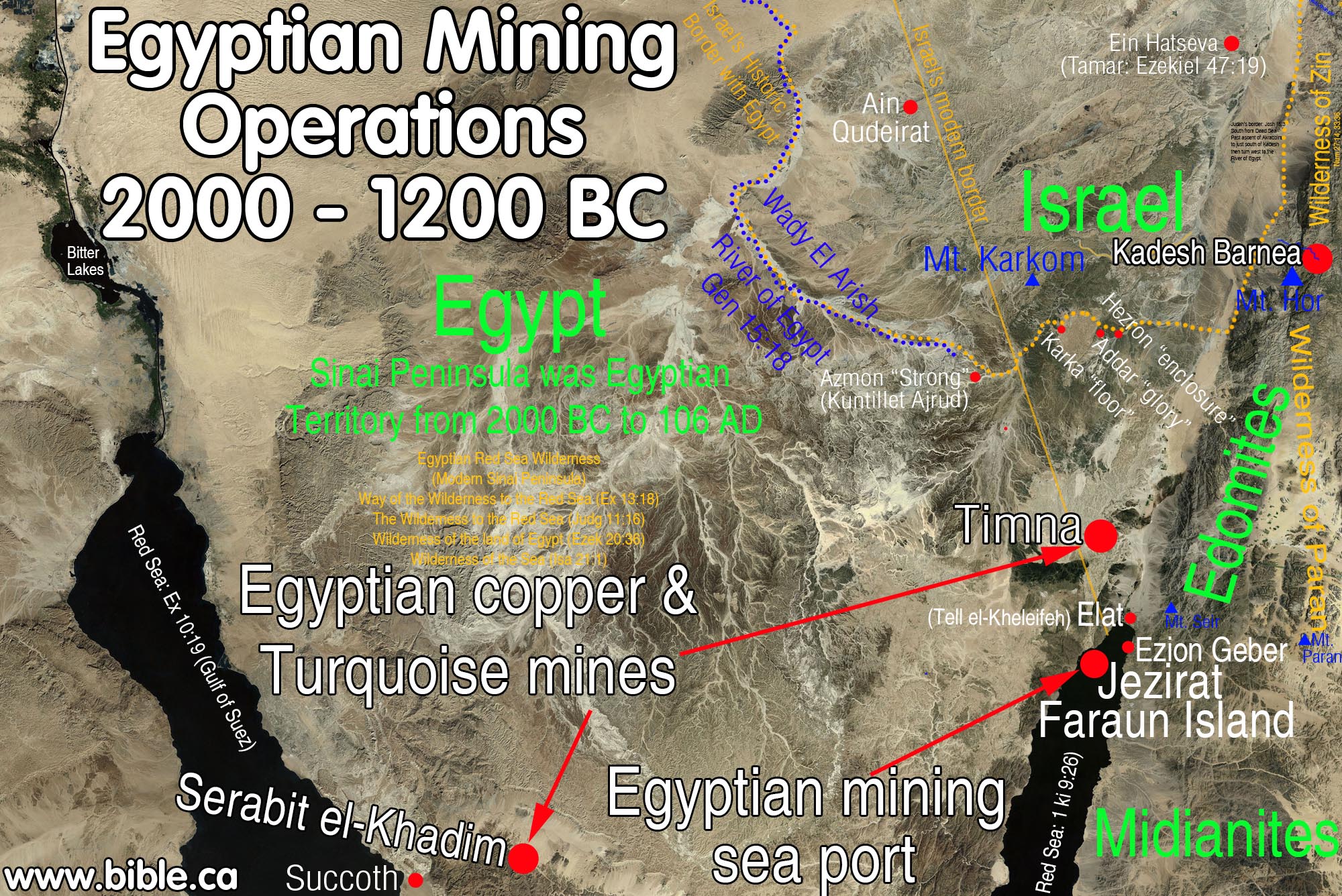
C. Timna Mines: Egyptian mines at the time of the Exodus:
1. In 1406 BC, at the time of the conquest under Joshua, the border bypassed north of Timna, which was under Egyptian control as on of their many mining operations.
2. The Kenites formed a partnership with Egypt from 1406 - 1200 BC, when the mines were abandoned.
3. It appears that Solomon started mining here about 950 BC. It was at this time when the border of Judah moved 80 km south from Kadesh (at Petra) down to the Red Sea. "I will fix your boundary from the Red Sea (Gulf of Aqaba) to the sea of the Philistines, and from the wilderness to the River Euphrates; for I will deliver the inhabitants of the land into your hand, and you will drive them out before you. " Exodus 23:31.
4. Although the Egyptians lost control of the Timna, area down to the Red Sea about 950 BC, they always retained control of the Sinai Peninsula.
5. The exodus occurred in 1446 BC and Israel crossed the Jordan in 1406 BC. During this time Timna and the port Island of Jezirat Faraun were under Egyptian control.
6. There were trade routes that crossed from Timna over to Egypt through the modern Sinai Peninsula. It was a heavily traveled and guarded route by the Egyptians. Remember that Serabit el-Khadim was the other major mine in the Sinai under Egyptian control.
7. This underscores how absurd it is to suggest the exodus route traveled through central Sinai using the same roads that the Egyptian miners used between Timna and Egypt.
8. We know that the promised land did not originally extent all the way down to the Red Sea (Gulf of Aqaba). Now we know the reason! God did not want to interfere with the Egyptians at Jezirat Faraun and Timna.
9. Archeologist
Beno Rothenberg wrote this: "Although there is sufficient evidence in
Egyptian sources for Ramesside (1250 BC) military campaigns in the Negev, Edom
and the Arabah, the Hathor Temple of Timna provides the
first archaeological evidence for actual and lengthy Egyptian control of this
area." (Timna,
Beno Rothenberg, 1969 AD)
D. Ancient Literary Sources the prove the Wadi el-Arish is the River of Egypt in Gen 15:18:
1. 670 BC: Esarhaddon’s 10th campaign says the Brook of Egypt had no water! (ANET 292, Esarhaddon)
a. Esarhaddon (680–669): 10th campaign proves the Brook of Egypt is the Wadi el-Arish:
b. The annal of Esarhaddon says the “Brook of Egypt” is dry without water and he had to supply his troops with buckets of water. A “Wadi” means a river with no water most of the year. The Nile is never dry. The Brook of Egypt is the same as the Wadi el-Arish.
c. “In my [Esarhaddon’s] tenth campaign, I directed my march [against … I ordered … ] towards the country … which is called in the language of the people of Nubia (Kûsu) and Egypt (Muṣur).… I called up the numerous army of Ashur which was stationed in.… In the month of Nisanu, the first month (of the year), I departed from my city Ashur. I crossed the Tigris and the Euphrates at (the time of) their flood; I advanced over the difficult territory (of my route) (as quick-footed) as a wild-ox. In the course of my campaign I threw up earthwork (for a siege) against Ba’lu, king of Tyre who had put his trust upon his friend Tirhakah (Tarqû), king of Nubia (Kûsu), and (therefore) had thrown off the yoke of Ashur, my lord, answering (my admonitions with) insolence. I withheld from them (i.e. the inhabitants of besieged Tyre) food and (fresh) water which sustain life. (Then) I removed my camp from Musru and marched directly towards Meluhha—a distance of 30 double-hours from the town of Apku which is in the region of Samaria (Sa-me-[ri-na]) as far as the town Raphia (in) the region adjacent to the “Brook of Egypt”—and there is no river (all the way)! By means of cords, chains (and) buckets I had to provide water for my army by drawing from wells.” (ANET 292, Esarhaddon)
d. Report on the tenth campaign in the annalistic text British Museum K 3082 + S 2027 + K 3086, published by R. W. Rogers, Haverford College Studies, No. 2 (1889), pp. 65 ff. Translation: H. Winckler, Untersuchungen zur altorientalischen Geschichte (Leipzig, 1889), pp. 97–98; Luckenbill, AR, II, §§554–559.” (ANET 292, Esarhaddon)
2. 450 BC: Herodotus: Arabs controlled Brook of Egypt/Arish/Rhinocolura seaport after Babylonian captivity:
a. “Now the only apparent way of entry into Egypt is this. The road runs from Phoenicia as far as the borders of the city of Cadytis [or Kadytis = Gaza], which belongs to the so-called Syrians of Palestine [Israel]. From Cadytis (which, as I judge, is a city not much smaller than Sardis) to the city of Ienysus [Arish= Tharu = Rhinocolura] the seaports belong to the Arabians; then they are Syrian again from Ienysus as far as the Serbonian marsh, beside which the Casian promontory stretches seawards; from this Serbonian marsh, where Typho is supposed to have been hidden, the country is Egypt.” (Herodotus, Hist. 3.5.1–3)
b. “The northern border of the land belonging to Kadytis must have lain somewhere between Ashkelon and Gaza. The striking change, of course, is that Gaza is in the hands of an Arabian. Cambyses had found this Arabian king in control of Kadytis (Gaza) when he passed through on his way to Egypt in 525 b.c.e., and his invasion of Egypt could not have been accomplished without the Arabian’s support in conveying his troops across the Sinai Desert. … He [Herodotus] is not very precise when he says “and Mt. Casius (Râs el-Kasrûn) and the Lake on the other,” but in the final analysis, the chief border city was Pelusion. However, Herodotus’ determination that it was at least a three-day march from Mt. Casius/Lake Serbonis to Ienysus may be compared with Titus’ march from Pelusion to Rhinocolura in three days (Josephus, War IV, 11, 5). Taking an average day’s march by an army in route as about 20–25 km, it is not hard to see that such an approximation (Herodotus does not try to be exact here) will bring us to el-ʿArîsh. This is the unquestioned site of Rhinocolura and must be the site of Ienysus (How and Wells 1912: I, 257). From the other side, there is also a clear testimony that Wâdī el-ʿArîsh must be naḫal Muṣri = naḥal Miṣraim “the Brook of Egypt” (Num 34:5; Josh 15:4, 14). This is in the Annals of Esarhaddon: 30 bēru qaqqar ultu Apqu ša pāṭi māt Sāme‹ri›n[a] adi Rapīḫi ana itê naḫal māt Muṣur ašar nāru lā išû ina ib[lē] ḫarḫarrē kalkaltu mê būri ina dilûti ummānī ušašqi Thirty double hours distance from Aphek, which is in the region of Sama‹ri›a(?) to Raphia, towards the Brook of Egypt, a place having no river, by ropes, by chains (and) buckets, I caused the troops to drink well water. The expression ana itê naḫal māt Muṣur, “as far as, towards the Brook of Egypt,” assures us that the Brook of Egypt is beyond Raphia (Rainey 1982). Further confirmation that the Brook of Egypt has to be identified with Wâdī el-ʿArîsh is the fact that עד־נחל מצרים (Isa 27:12) is rendered by ἕως Ῥινοκορούρων in the LXX. As demonstrated by Titus’ march mentioned above, Rhinocolura was three days’ march from Pelusion. Esarhaddon also confirms that there was a town, āl Arṣâ ša itê naḫal māt Muṣri “the town of Arṣâ which is beside the Brook of Egypt” (Borger 1956: 33 Klch A, 16; et al.). Therefore, we can affirm the equation: Rhinocolura = Ienysus = Arṣâ. How, except for the first, the various name changes of this place at the mouth of the Brook of Egypt (= Wâdī el-ʿArîsh) came about is clouded in mystery. The linguistic origin of Ienysus is unknown although one would assume that it must be Semitic.” (Herodotus’ Description of the East Mediterranean Coast, Anson F. Rainey, BASOR 321, p60, 2001 AD.
3. 250 BC: The Septuagint (LXX): substitutes "the brook of Egypt" in Isa 27:12 for Rhinocorura,
- The Septuagint substitutes "the brook of Egypt" in Isa 27:12 for Rhinocorura. This shows that everyone knew that the River of Egypt in Gen 15:18 was the same as Rhinocorura and ancient Tharu at the time of the exodus in 1446 BC.
- "In that day the Lord will start His threshing from the flowing stream of the Euphrates to the Rhinocorura (LXX), and you will be gathered up one by one, O sons of Israel. " Isaiah 27:12
3. 150 BC: Polybius: Rhinocorura is the border of Egypt (Polybius, Histories 5:80)
- Ptolemy was marching from Pelusium to Rhinocorura to Raphia to Gaza. Rhinocorura (Tharu) was the border of Egypt for it says, Raphia was the first city you reach after leaving Egypt. Today, Raphia is the Modern border between Egypt and Israel.
- “Ptolemy, marching on Pelusium, made his first halt at that city, and after picking up stragglers and serving out rations to his men moved on marching through the desert and skirting Mount Casius and the marshes called Barathra. Reaching the spot he was bound for on the fifth day he encamped at a distance of fifty stades from Raphia, which is the first city of Coele-Syria on the Egyptian side after Rhinocorura. Antiochus was approaching at the same time with his army, and after reaching Gaza and resting his forces there, continued to advance slowly. Passing Raphia he encamped by night at a distance of ten stades from the enemy. At first the two armies continued to remain at this distance from each other, but after a few days Antiochus, with the object of finding a more suitable position for his camp and at the same time wishing of encourage his troops, encamped so near Ptolemy that the distance between the two camps was not more than five stades. Skirmishes were now frequent between the watering and foraging parties, and there was occasional interchange of missiles between the cavalry and even the infantry.” (Polybius, The Histories 5:80, 150 BC)
4. 100 BC: Judith 1:9: River of Egypt is not the Pelusiac branch of the Nile
- Written in 100 BC, the book of Judith 1:9 proves the brook of Egypt is the Wadi el-Arish: "And to all that were in Samaria and the cities thereof, and beyond Jordan unto Jerusalem, and Betane, and Chellus, and Kades (Kadesh), and the river of Egypt, and Taphnes, and Ramesse, and all the land of Gesem," Judith 1:9
- Foremost, notice that the sequence proves the Nile is not the River of Egypt. Tahpanhes at Tel Defenna (Jeremiah 2:16; 43:7; 43:8) is east of the Pelusiac branch of the Nile River. Her is the order of places in Judith:
- River of Egypt,
- Taphnes,
- Ramesse,
- Land of Goshen.
- “The river of Egypt is likely the wadi of Egypt, Nachal Mizrayim (Num 34:5), also called Wadi el-Arish. It separates Egypt and Judah. Tahpanhes, Rameses, Tanis, and Memphis were major cities in the Nile Delta. Finally, Ethiopia is chosen as the southern boundary.” (Hermeneia, A Commentary on the Book of Judith, Judith 1:9, Lawrence M. Wills, 2019 AD)
- “the brook [lit. “the river”] of Egypt. The Greek probably refers not to the Nile itself but to “the brook [Heb nḥl] of Egypt” (mod. Wadi el-Arish), which geographically separates Palestine and Egypt (cf. 1 Kings 8:65; 2 Chr 7:8; Josh 15:4). In speaking about the brook of Egypt, the Assyrian kings Sargon I and Sennacherib expressly stated there was no water in it (cf. ANET, pp. 286, 290, 292).” (Judith, AYBC, Carey A. Moore, Judith 1:9, 2008 AD)
5. AD 110: Josephus: Simeon borders Egypt (Sinai Peninsula) and Arabia (Petra); Rhinocurura is in Egypt
- "The lot of Simeon (inside Judah), which was the second, included that part of Idumea [Edom] which bordered upon Egypt and Arabia." (Josephus, Antiquities 5.82)
- Josephus give two separate accounts of how Herod the Great escaped from the king of Arabia, into Egypt about 25 BC. Notice that as Herod traveled along the shoreline from Israel to Egypt, he stopped at an Egyptian Temple, that was very near Rhinocurura. This proves that as late as 25 BC Rhinocurura was the border between Egypt and Israel.
- Hereupon he [Herod the Great] resolved to go away, and did go very prudently the road to Egypt; and then it was that he lodged in a certain temple; for he had left a great many of his followers there. On the next day he came to Rhinocorura, and there it was that he heard what had befallen his brother. (Josephus, Antiquities 14.374, 25 BC)
- "So when Herod had found that the Arabians were his enemies, and this for those very reasons whence he hoped they would have been the most friendly, and had given them such an answer as his passion suggested, he returned back and went for Egypt. Now he lodged the first evening at one of the temples of that country, in order to meet with those whom he left behind; but on the next day word was brought him, as he was going to Rhinocurura, that his brother was dead, and how he came by his death; and when he had lamented him as much as his present circumstances could bear, he soon laid aside such cares, and proceeded on his journey." (Josephus, Wars 1.277, 25 BC)
- Josephus records the line of cities in sequential order from Gaza, in Israel towards Egypt. Notice the order is Joppa, Jamnia, Ashdod, Gaza, Anthedon, Raphia, and Rhinocorura. Rhinocorura being the ancient border between Egypt and Israel as stated in Gen 15:18 to Abraham. (River of Egypt or wadi-el-Arish) "Now at this time the Jews were in possession of the following cities that had belonged to the Syrians, and Idumeans, and Phoenicians: At the seaside, Strato's Tower, Apollonia, Joppa, Jamnia, Ashdod, Gaza, Anthedon, Raphia, and Rhinocorura." (Josephus, Antiquities 13.395)
- Josephus, at the time of Titus's destruction of Jerusalem in 70 AD, says that the border between Egypt and Israel (actually Syria at this time) was at Rhinocorura. Josephus said that Raphia was the first town within "Syria". Raphia is the modern border town today between Israel and Egypt. What this means is that the modern boundaries between Egypt and Israel closely match the ancient boundaries. Josephus says that Rhinocorura was a three-day journey from Pelusium. "So Titus marched on foot as far as Nicopolis, which is distant twenty furlongs from Alexandria; there he put his army on board some long ships, and sailed upon the river along the Mendesian Nomus, as far as the city Thmuis; there he got out of the ships, and walked on foot, and lodged all night at a small city called Tanis. His second station was Heracleopolis, and his third Pelusium; he then refreshed his army at that place for two days; and on the third passed over the mouths of the Nile at Pelusium; he then proceeded one station over the desert, and pitched him camp at the temple of the Casian Jupiter, and on the next day at Ostracine. This station had no water; but the people of the country make use of water brought from other places. After this he rested at Rhinocorura, and from thence he went Raphia, which was his fourth station. This city is the beginning of Syria. For his fifth station, he pitched his camp at Gaza; after which he came to Ascalon, and thence to Jamnia, and after that to Joppa, and form Joppa to Cesarea, having taken a resolution to gather all his other forces together at that place." (Josephus, Wars 4.659, 70 AD)
6. AD 325: The Onomasticon by Eusebius
- Eusebius wrote a book called the Onomasticon in about 325 AD. The Onomasticon is a dictionary of places, towns and countries. It is an ancient atlas.
- We have copies of the Onomasticon down to the time of Jerome.
- The Madaba map (600 AD, see below) was based in part upon the Onomasticon.
- "Bethaphu (Jos 15:53), in the tribe of Judah. A village near Raphia, on the 14th milestone on the road to Egypt, which marks the boundary of Palestine." (Eusebius, Onomasticon 50,18-20; Jerome 51,18-19)
- Eusebius says the actual border between Israel and Egypt was just west of Raphia. Since we know that the town of Tharu (Rhinocorura) was under Egyptian control, this is exactly what we expect and fits perfectly with where the border was located.
7. AD 400: Jerome: Raphia is near the border of Egypt (Jerome, commentary on Daniel 11:10-14)
- Jerome says the border of Egypt bordered on Raphia. This is east of the Wadi el-Arish.
- Raphia is where the modern border of Israel is located.
- "In a battle near the town of Raphia, which is on the borders of Egypt, Antiochus lost his entire army and was almost captured while escaping through the desert. He retreated from Syria, and eventually the war was concluded with a treaty on certain conditions." (Jerome, Daniel 11:10-14, 400 AD)
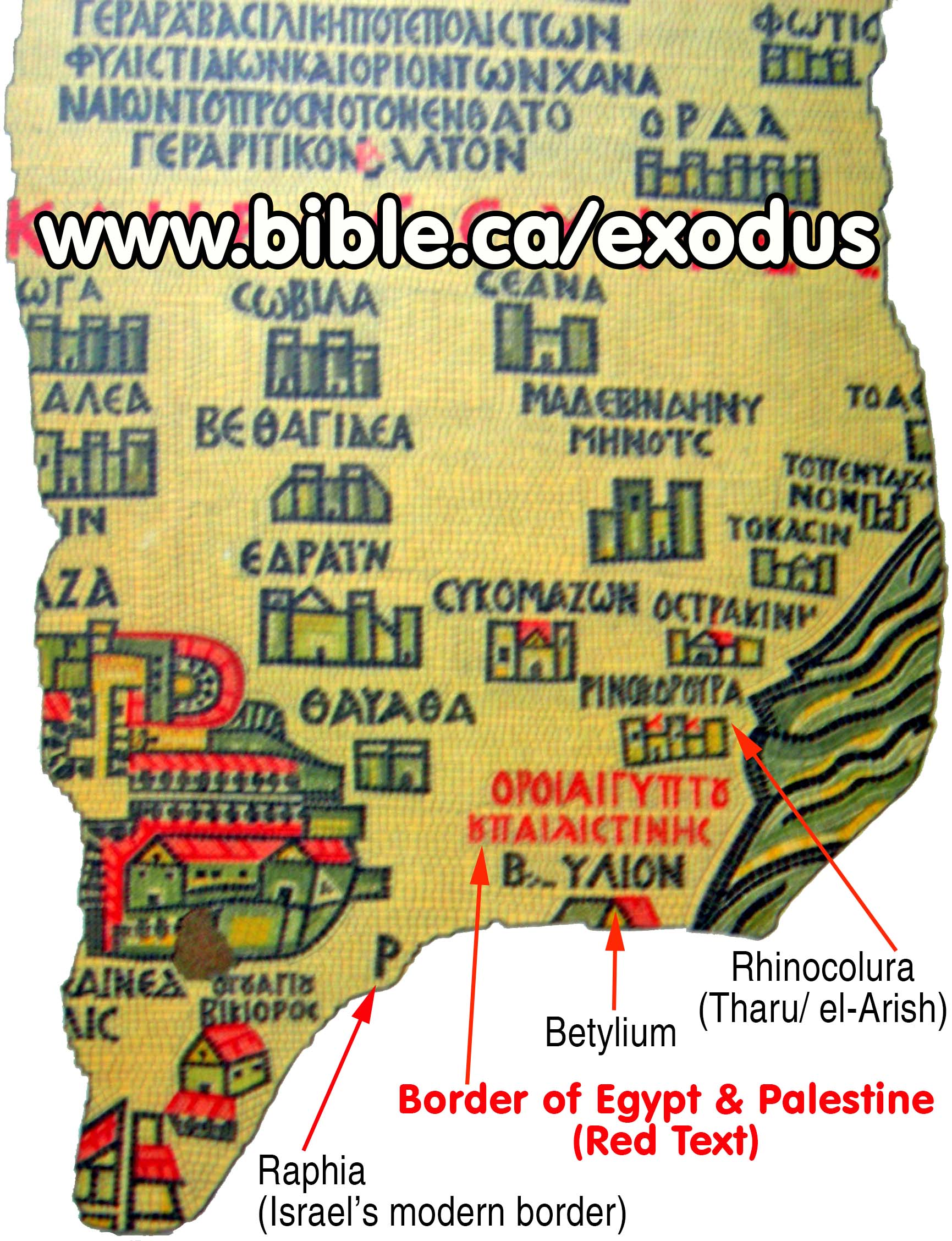
8. AD 542: Madaba Map: States in Greek that Egyptian border is between Raphia and Rhinocorura
a. The "Madaba map" is a mosaic floor laid in 542 AD.
i. The Madaba map was based directly upon Eusebius’ "Onomasticon" (dictionary of cities) written by Eusebius in 325 AD.
ii. It is in St. George's Orthodox church in the city of Madaba, Jordan.
iii. The map is famous because it is one of the oldest maps of Bible lands in the world.
b. It is a mosaic that confirms that the Wadi el-Arish is the border between Israel and Egypt.
i. The proof doesn't get much better than this! An actual in situ mosaic we can jump on an airplane today and see for our selves with our own eyes!
ii.
The Madaba map has the words: "Border of Egypt and Palestine"
just between the towns of Bitylium and Rhinocorura are the following words in
the Madaba Map: Border of Egypt and Palestine "Horoi Aigyptou kai
Paleaistines".
Conclusion:
- From scripture, there is simply no doubt that the historic and Biblical border between Egypt and Israel was the Wadi el-Arish or the River/Brook of Egypt.
- Suggesting that the Pelusiac branch of the Nile River is the “River of Egypt” in Genesis 15:18 is absurd:
- Was Israel already in the promised land in Goshen, because Tel el-Dab’a is on the eastern side of the Pelusiac branch of the Nile River?
- Was Israel in the promised land before and after they crossed the Red Sea at the Bitter lakes?
- Was Israel in the promised land while at Mt. Sinai located at St. Catherine’s, Mt. Musa in the Sinai Peninsula?
- Was the Sinai Peninsula part of the tribal lands of Judah and Simeon?
- In case you are an agnostic and are having trouble with answering the above rhetorical questions, the answer to all is NO!
- Esarhaddon (680–669): 10th campaign in 670 BC proves the Brook of Egypt is the Wadi el-Arish:
a. The annal of Esarhaddon says the “Brook of Egypt” is dry without water and he had to supply his troops with buckets of water. A “Wadi” means a river with no water most of the year. The Nile is never dry. The Brook of Egypt is the same as the Wadi el-Arish.
b. “the town Raphia (in) the region adjacent to the “Brook of Egypt”—and there is no river (all the way)! By means of cords, chains (and) buckets I had to provide water for my army by drawing from wells.” (ANET 292, Esarhaddon)
- The Entire Sinai Peninsula was not a mere "Egyptian protectorate" but under the absolute military control of Egypt from the time of 1800 BC down to the first century AD. The Egyptian mines at Timna north of Elat clearly demonstrate this.
- The association of Tharu and Rhinocorura as prison towns where inmates had their noses cut off proves they are the same city at two different time periods.
- Ancient Egyptian literary sources identify Tharu as having the following markers:
- A Late Bronze age prison camp where inmates had their noses cut off.
- A Late Bronze age Egyptian fortress.
- Located on the border of Egypt as a last stop before entering Canaan at Raphia and Gaza.
7. Ancient literary sources confirm Wadi el-Arish is the River of Egypt in Gen 15:18
a. 670 BC: Esarhaddon’s 10th campaign says the Brook of Egypt had no water! (ANET 292, Esarhaddon)
b. 250 BC: The Septuagint (LXX): substitutes "the brook of Egypt" in Isa 27:12 for Rhinocorura,
c. 150 BC: Polybius: Rhinocorura is the border of Egypt (Polybius, Histories 5:80)
d. 100 BC: Judith 1:9: River of Egypt is not the Pelusiac branch of the Nile
e. AD 110: Josephus: Simeon borders Egypt (Sinai Peninsula) and Arabia (Petra); Rhinocurura is in Egypt
f. AD 325: The Onomasticon by Eusebius
g. AD 400: Jerome: Raphia is near the border of Egypt (Jerome, commentary on Daniel 11:10-14)
h. AD 542: Madaba Map: States in Greek that Egyptian border is between Raphia and Rhinocorura
- Archaeologists have misidentified ancient Tharu at Tel Habuwa which is located 2 km east of the modern Suez Canal and has no trace of a prison camp.
By Steve Rudd: Contact the author for comments, input or corrections.
