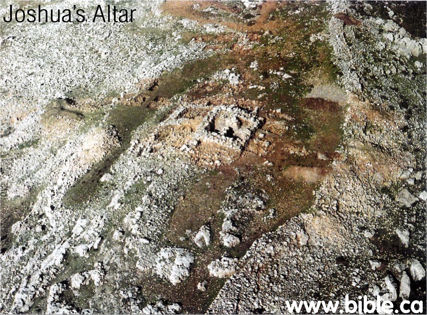
Joshua's Altar on Mt. Ebal
Deuteronomy 27:5; Joshua 8:30
AD 2019 Mt. Ebal Curse Tablet: “Defixio”
Monograph by Steven Rudd on AD 2019 Mt. Ebal Lead Curse Tablet
"'You shall make an altar
of earth for Me, and you shall sacrifice on it your burnt offerings and
your peace offerings,
your sheep and your oxen; in every place where I cause My name to be
remembered, I will come to you and bless you.(Exodus 20:24)
'If you make an altar of stone for Me, you shall
not build it of cut stones, for if you wield
your tool on it, you will profane it.
'And you shall not go up by steps to My altar,
so that your nakedness will not be exposed on it.' " (Exodus 20:25-26)
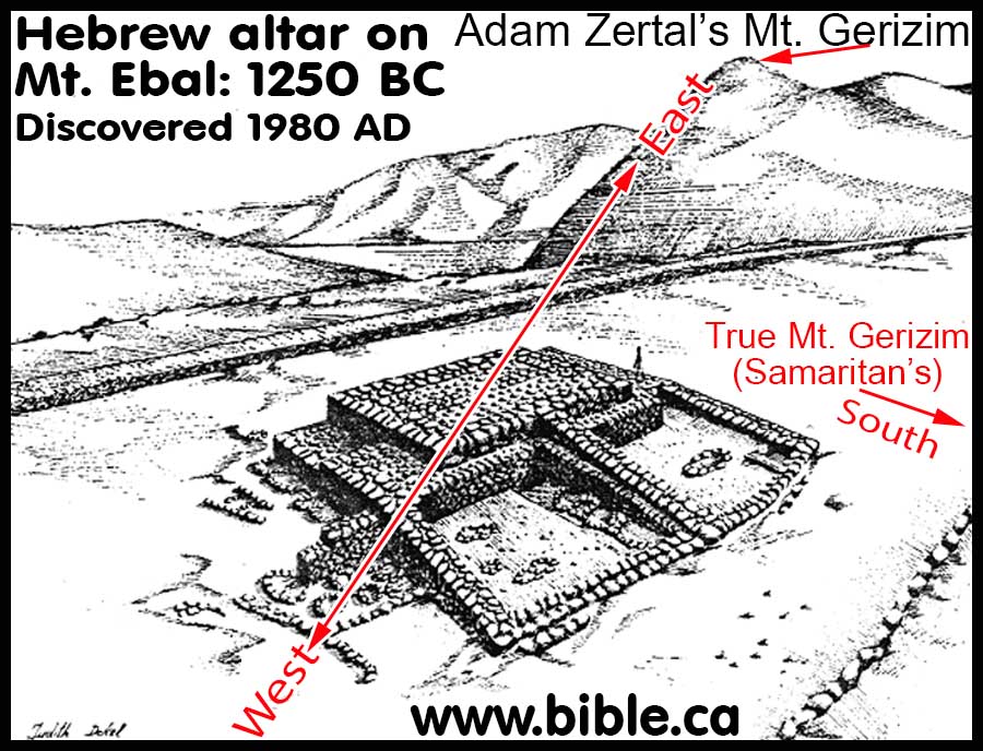
Altar of Joshua, Mt. Ebal
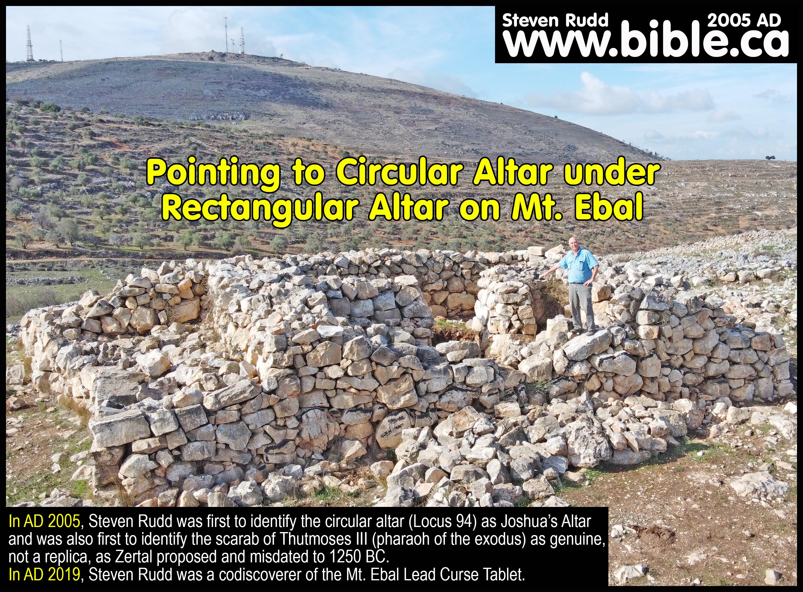
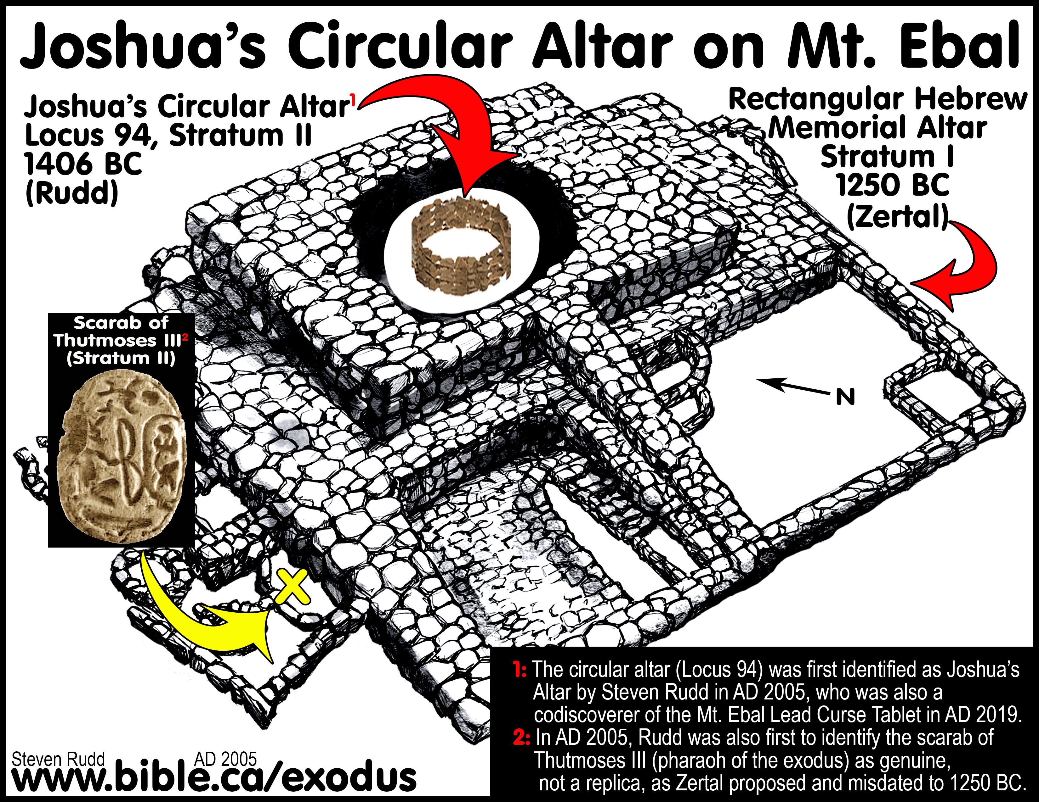
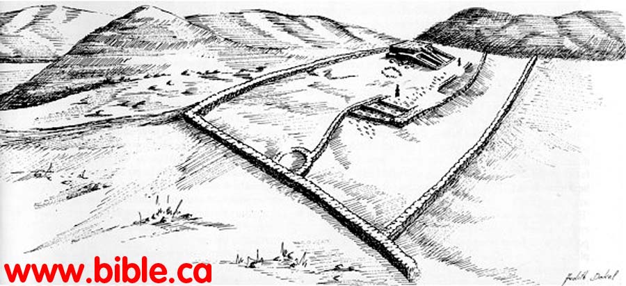
1. In November AD 2004, Steven Rudd conducted restoration work under the direct supervision of Adam Zertal on Joshua’s Altar at Mt. Ebal. Zertal identified two strata in his 1985 excavation reports. Zertal considered the rectangular alter (Stratum I) to be Joshua’s altar which he dated to about 1250 BC at the time of Rameses II. Zertal dated the circular altar (Locus 94, Stratum II) under the rectangular to around 1300-1275 BC. Till his death, Zertal always identified Joshua’s altar as the rectangular structure and never believed the round circular altar (Locus 94/stratum II) was built by Joshua. Zertal believed Joshua built the rectangular alter over top of an older circular alter that predated the rectangular altar by 25-50 years. The elephant in the excavation room apparent to Steven Rudd was that the exodus occurred in 1446 BC under Thutmoses III, not 1250 BC under Ramses II as Zertal believed. This meant that it was impossible for the rectangular altar to be built by Joshua.
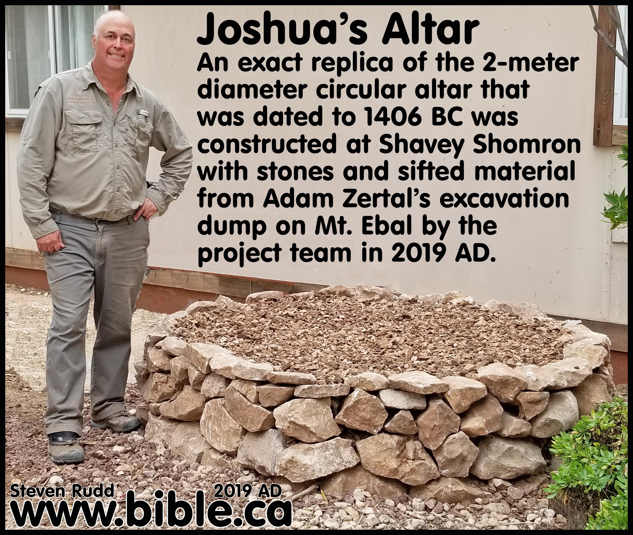
2. In AD 2005, Steven Rudd studied Zertal’s excavation reports, and was the first one to redate the circular alter to 1406 BC and identify it as Joshua’s altar, not the rectangular structure above. This was based upon Biblical chronology and the Thutmoses III scarab Zertal excavated. Rudd rejected (in 2005 AD) Zertal’s claim that the Thutmoses III scarab was a replica created at the time of Ramses II. All these details were published by Rudd in AD 2005 on the webpage, www.bible.ca/archeology/bible-archeology-altar-of-joshua.htm, which has enjoyed a first hit “Google” search result for “Joshua’s Altar” since AD 2005. During this time, it was the most read monograph on Joshua’s altar in the world, as it true today. Gradually, many came to agree with Rudd’s conclusion that the round altar (Locus 94, Stratum II) was Joshua’s altar that dated to 1406 BC.
3. Steven Rudd’s personal plea to Zertal in 2005:
a. “We would humbly invite Adam Zertal to read this paper on the Exodus being at 1446 BC, not 1250 BC. The altar changed him from a Bible skeptic to a Bible believer. We suggest that he go all the way and accept the Bible's date of 1406 BC when Joshua built his altar. Zertal probably knows enough about the site that he could actually make a good case for this round ring of rocks being dated to 1406 BC, but simply could not because he mistakenly believed the exodus happened in 1250 BC. If he accepts the Bible's date of the exodus of 1446, then he can date the 6.5 foot diameter circle of stones up to 150 years earlier and still be within the time Israel crossed the Jordan. He can contact the author (Steven Rudd) by email here if he wishes further discussion.”
AD 2022: Multi-spectral scanning project of plaster excavated by Adam Zertal:
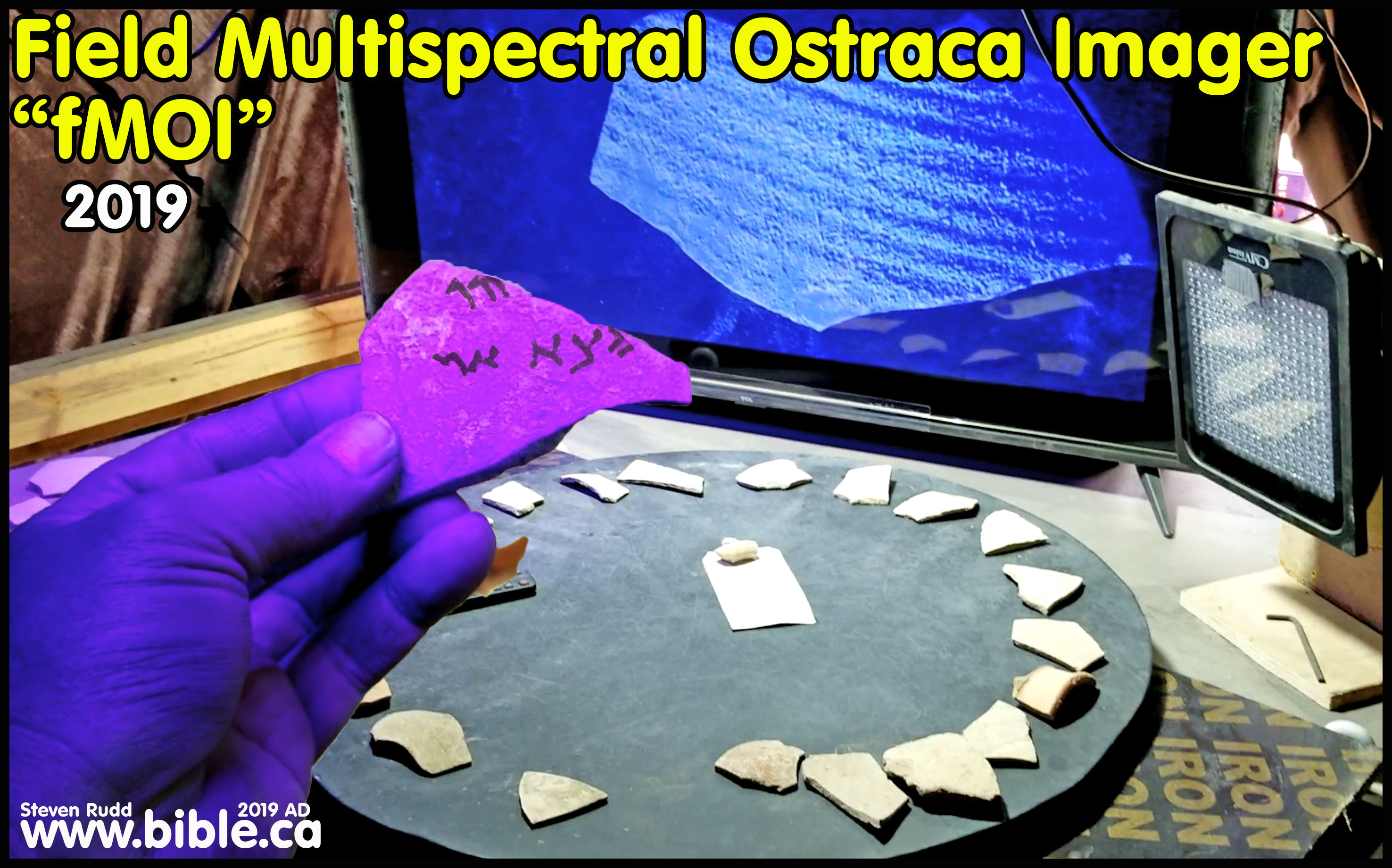
1. Scripture said Joshua’s altar was plastered, and the ten commandments were written thereon. In AD 1985 Adam Zertal discovered plaster (currently at University of Haifa) which may be scanned with the optical ostraca detector invented by Steven Rudd used on site at the Shiloh excavation since AD 2018 (see photo below). This scientific imaging machine allows archaeologists to see if any writing is visible under UV and Infrared light.
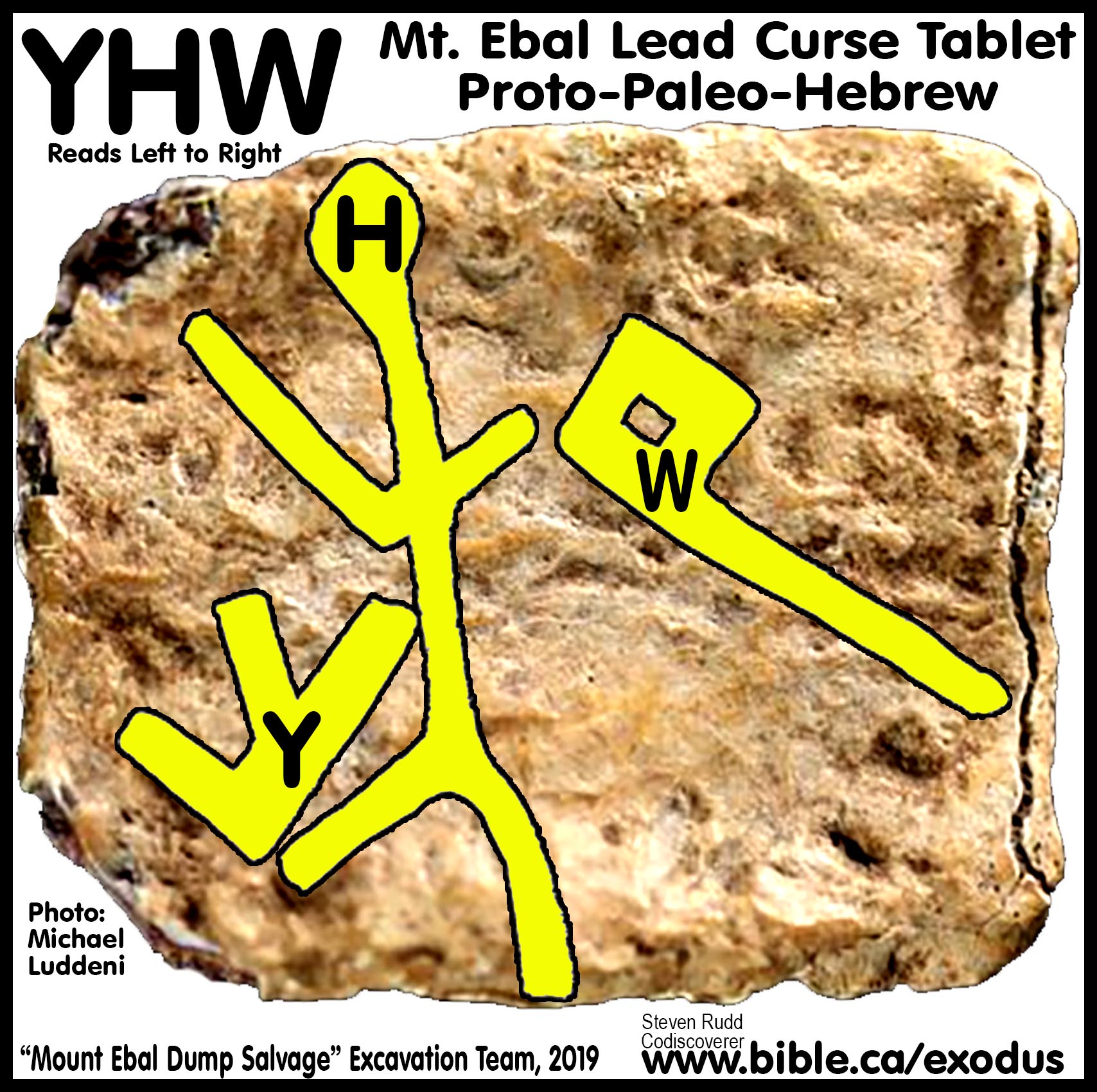
Lead Curse Tablet from Mt. Ebal
Monograph by Steven Rudd on AD 2019 Mt. Ebal Lead Curse Tablet
1. The M.E.D.S. (Mount Ebal Dump Salvage) team spent two weeks at Mt. Ebal in December 2019 to January 2020 and at the Shavey Shomron kubutz in Israel west of Nablus. Steven Rudd was a staff member of the M.E.D.S. excavation team who designed and built the dry and wet sifting machines to reexamine Adam Zertal’s 1980’s excavation dump piles at Joshua’s Altar on Mt Ebal. Although all members participated in all aspect of the excavation, it was Frankie Snyder who discovered the Lead Curse Tablet in the wet sifting machine. It would turn out to be one of the most important archaeological finds in 100 years because it was the oldest Hebrew text ever discovered, and the oldest reference to God’s personal name, “YHWH”, which God first revealed to Moses at the burning bush in 1447 BC at the foot of Mt Sinai near Midian in Saudi Arabia. It also confirmed the inspiration of scripture by showing that Mt. Ebal was the mountain of curses in Deut 27. What you read in the book you find in the ground.
2. In 2022, tomographic scans of the 2019 Mt Ebal Curst Tablet were completed by two epigraphers, Pieter Gert Van der Veen of the Academy of Sciences of the Czech Republic, and Gershon Galil of the University of Haifa. These scientists employed advanced tomographic scans to recover the hidden text. All the letters on the inside belong to the same physical level, indicating they were part of a script written on a flat strip of lead then folded into a square. Daniel Vavrik and his colleagues from the Institute of Theoretical and Applied Mechanics of the Academy of Sciences of the Czech ensured the accuracy of the raw data which the team interpreted. An academic, peer-reviewed monograph of the Lead Curse Table published in AD 2022 was the result of the collaborative efforts of Scott Stripling, Gershon Galil, Ivana Kumpova, Jaroslav Valach, Pieter Gert van der Veen, Daniel Vavrik, and Michal Vopalensky.
|
M.E.D.S. team: 22 Codiscoverers of the Mt. Ebal Lead Curse Tablet, December 2019 Monograph by Steven Rudd on AD 2019 Mt. Ebal Lead Curse Tablet |
|
|
(In alphabetical order) 1. Melody Bogle (Artist) 2. Miki Clouser (Volunteer) 3. Sherrie Dwyer (Volunteer) 4. Jacob Figueroa (Volunteer) 5. Brent French (Volunteer) 6. Emmeline Gerhart (Volunteer) 7. Perry Gerhart (Special Projects Engineer) 8. Greg Gulbrandsen (Wet Sifting Supervisor) 9. Ellen Jackson (Metal Detectorist) 10. Zvi Koenigsberg (Laison) 11. Scott Lanser (ABR Director) 12. Kevin Larsen (Staff) 13. Suzanne Lattimer (Staff) 14. Abigail Leavitt (Asst. Director) 15. Aaron Lipkin (Logistics Coordinator) 16. Mike Luddeni (off site photographer) 17. Jordan McClinton (Volunteer) 18. Steve Rudd (Wet Sifting Engineer) 19. Henry Smith (Administrative Director) 20. Frankie Snyder (Small Finds Specialist) 21. Scott Stripling (Director) 22. Gary Urie (Volunteer) |
|
Introduction:
1. Adam Zertal excavation reports:
a. An Early Iron Age Cultic Site On Mount Ebal: Excavation seasons 1982-1987, Preliminary report by Adam Zertal
b. Has Joshua's Altar Been Found on Mt. Ebal? by Adam Zertal (BAR, Feb 1985)
c. The cult site on mount 'ebal. A stone mound on the northeastern ridge. By Adam Zertal (Nov 2004)
2. Site location: 50 km N of Jerusalem: GPS: 32.239679N 35.287205E
3.
On April 6, 1980, Adam Zertal, Ph.D, Prof. Of
Archeology, Univ. of Haifa was doing a formal archaeological survey of the
traditional lands of Manasseh and discovered a Hebrew Altar that dated to 1250
BC. Using pottery to date the site Zertal said: "More
important, however, is that they [the pottery] fix a date for the construction
of the altar - approximately 1250 B.C.E." (Adam Zertal 2004 AD)
Zertal is the author of "A Nation is Born: The Mt. Ebal Altar and the
Beginnings of the Nation of Israel". See also: (Zertal, A. 1986/87 An
Early Iron Age Cultic Site on Mt. Ebal: Excavation Seasons 1982-1987. Tel Aviv
13-14: 105-65. 1993.) and (The New Encyclopedia of Archaeological Excavation in
the Holy Land, Vol. 1, ed. E. Stern. Jerusalem: Israel Exploration Society and
Carta. Ebal, Mount. Pp. 375-77)
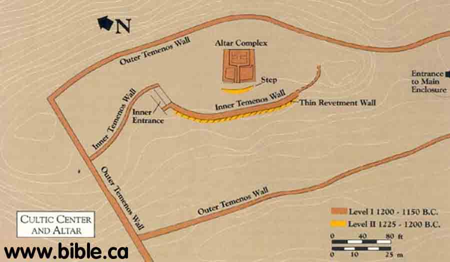
4. The site at Mt. Ebal had two occupation levels. Zertal calls the older occupation "level II" which he dates ~1300-1270 BC and the younger level I to 1250 BC.
a.
If this site is no older than 1300 BC, then none of it could be built by
Joshua, because the exodus took place in 1446 BC.
However, this is a Hebrew altar built during the time of Deborah the Judge and
underneath we believe is the actual altar of Joshua that should be dated to
1406 BC since a scarab from Tuthmoses III was found but wrongly dated to 1250
BC.
b. "SUMMARY: A small cult site for offering sacrifices was established here in stratum 2. As evidence. the excavator cites the finds uncovered beneath the main stratum IB structure and the burnt areas, which contained animal bones. A four-room house adjoining the cult center was apparently the residence of its attendants. Because of the small size of the site in this stratum, it is assumed that it served as a family or tribal cult site. The excavator similarly interprets the stratum 1B remains as a main cult site of the Israelite settlers. Confirmation of this view is provided by the absence of dwellings. the presence of stone installations containing offerings, the singular architectural plan, and the ashes mixed with animal bones. The large double enclosure and the finely built main structure are in this stratum: The latter was apparently intended to serve as the focal point of ceremonies for a large assembly. The enclosure and the main building were abandoned after several decades of use and covered with a layer of stones (stratum IA). This was probably done deliberately, to bury the site. This interpretation of the site has aroused a great deal of controversy among scholars. Whereas the excavator viewed the main building as a large sacrificial altar, N. Na'aman identified the area as Shechem's main cult site in the Iron Age I—namely, as the "Tower of Shechem," and interpreted the central enclosure as the "house of El-berith" (Jg. 9:46). Some scholars (A. Mazar, M. D. Coogan, I. Finkelstein) agree that the site has a cultic nature but do not interpret it as an altar; others (A. Kempinski, A. F. Rainey) reject cultic interpretation of the Mount Ebal remains and tend to view the structure as a fortified tower." (Adam Zertal, New Encyclopedia of Archaeological Excavation in the Holy Land, Mt. Ebal, 1993 AD)
5.
Adam Zertal’s excavation top plan of Stratum II: 1406 BC (our date,
Zertal dates it to 1270 BC)
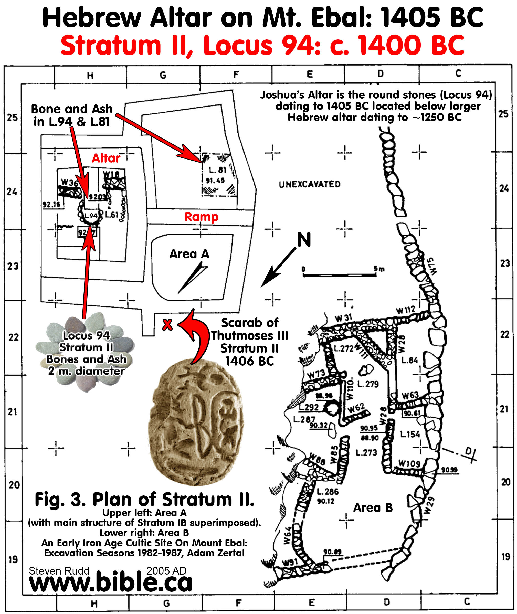
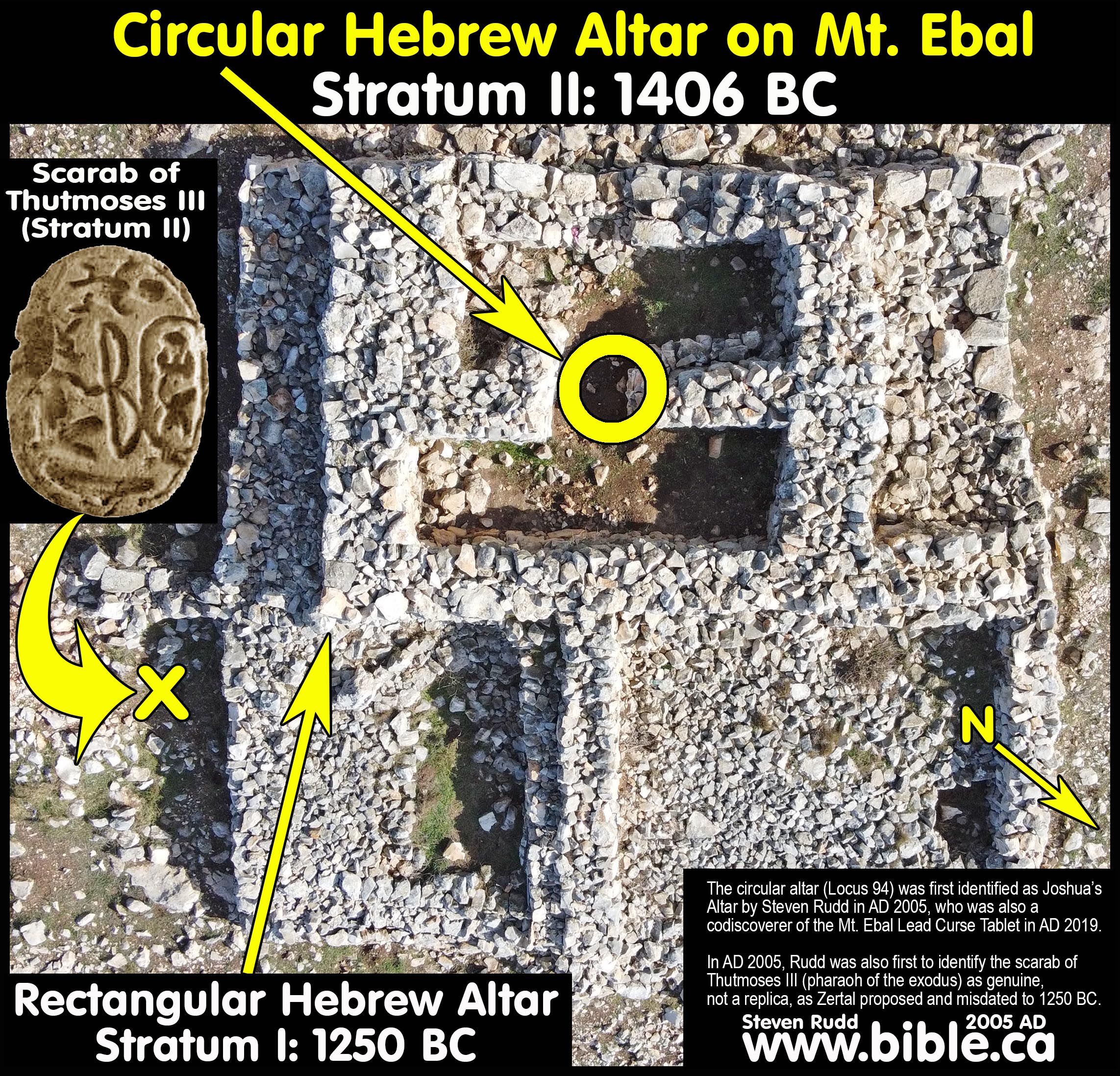
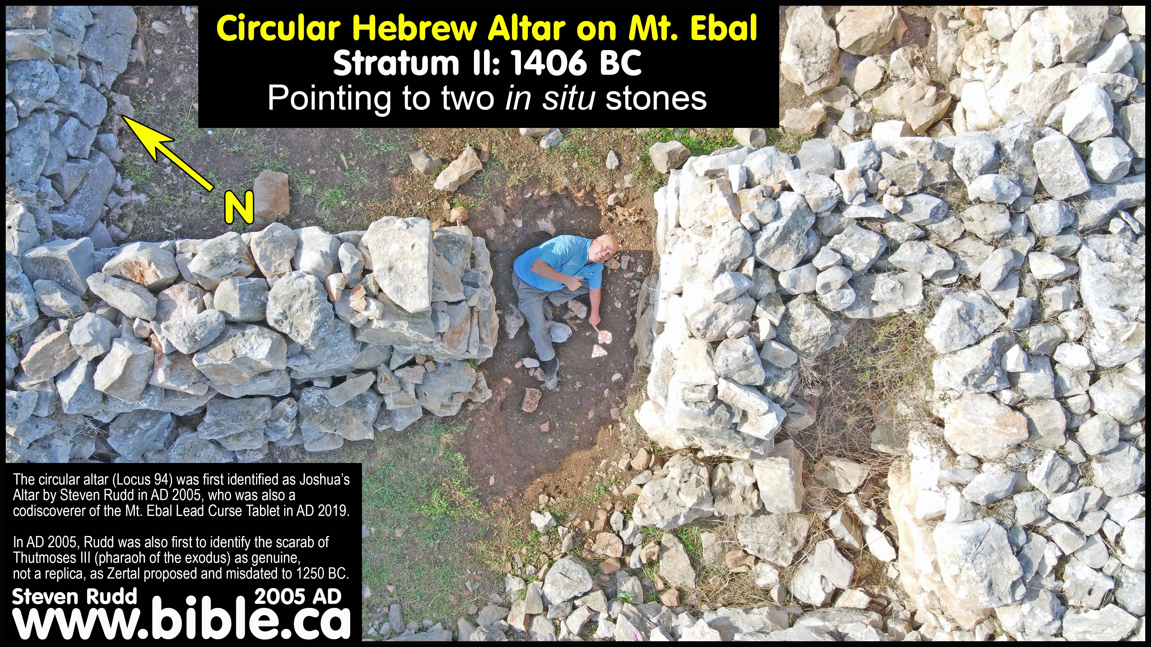
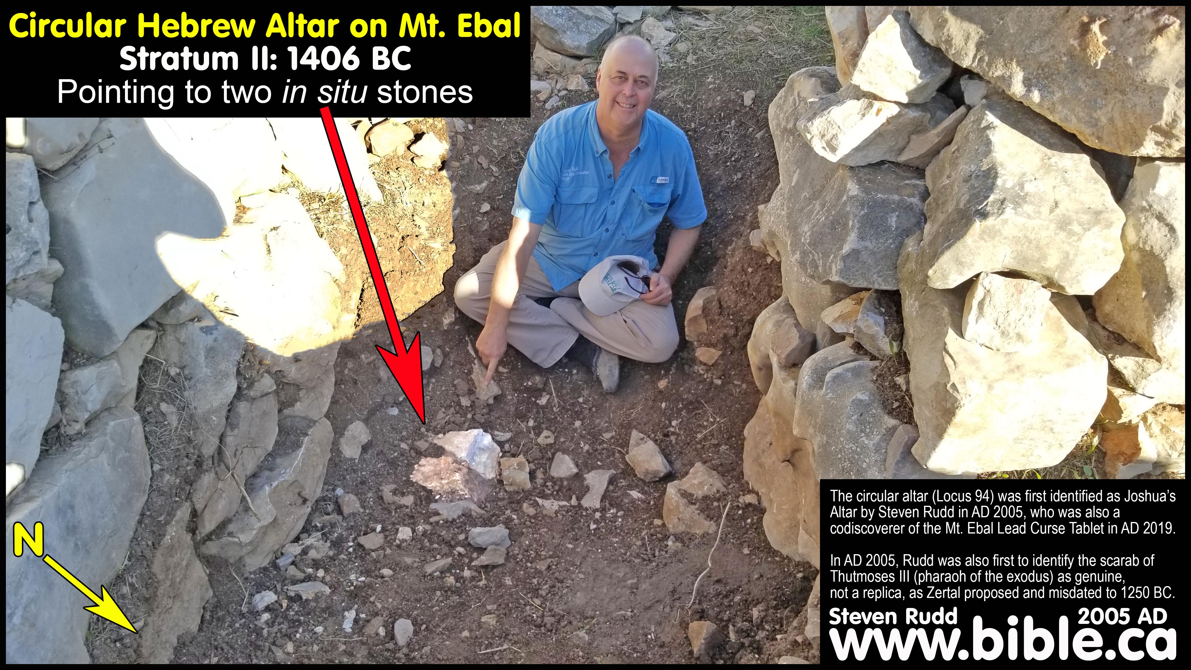
a. Joshua’s altar is the round circular altar (locus 94, Stratum II) is directly below the younger square altar.
b. In the round altar were found burnt bones and ash. The round altar is in the exact geometric center of the square altar platform where sacrifices were made. We speculate that since Abraham and Isaac lived in the area and built altars, we believe that the site dates back to the time of Abraham and that Joshua built his altar on top of Isaac's who in turn built his altar on top of Abraham's. In other words, the site has a long tradition of use as an altar from 2000 BC down to 1250 BC.
2. Zertal
identified only two occupation levels, so he may have assigned the other
circular installations seen on the Stratum I top plan to the wrong phase and
should be on the Stratum II top plan.We agree that there are
clearly two occupation levels. The rectangular altar we see today was built
about 1250 BC. The 2 meter (6.5 foot) diameter circular stone structure with
burnt kosher bones inside was is located directly beneath the rectangular altar
and was built about 1406 BC by Joshua. (We call it an altar, Zertal does not.
We date it to 1406 BC, Zertal dates it to ~1270 BC)
 .
.
6.
Adam Zertal’s excavation top plan of Stratum I: 1250 BC (our date,
Zertal also dates it to 1250 BC)
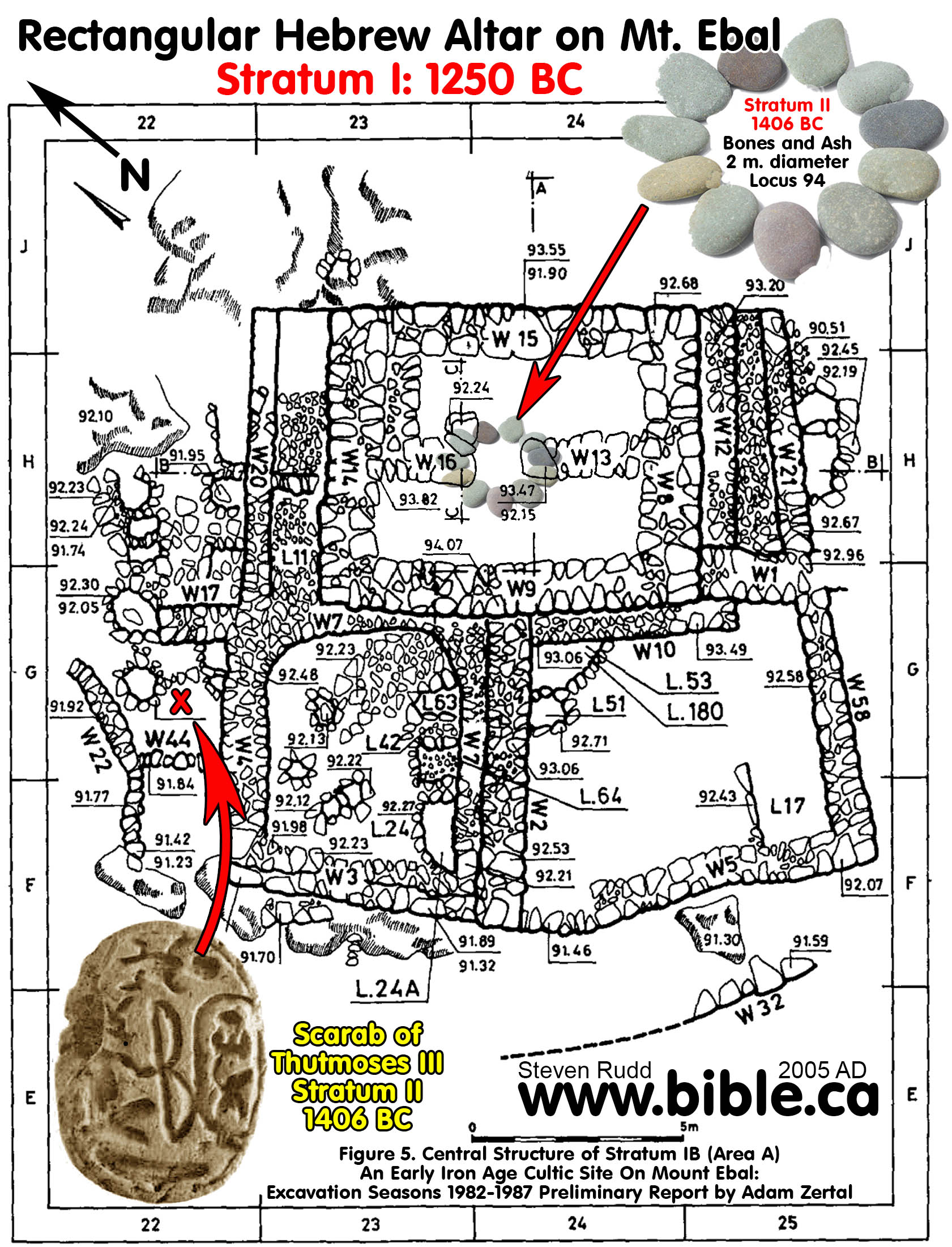
a. Zertal identified only two occupation levels, so he may have assigned the other circular installations seen on the Stratum I top plan to the wrong phase and should be on the Stratum II top plan. Since Zertal dated the rectangular altar to ~1250 BC, it cannot be Joshua’s altar because the conquest started in 1406 BC and Joshua build his altar on Mt. Ebal in 1406 BC. The rectangular structure, therefore, may be either a later memorial altar of the earlier round altar of Joshua.
b. This altar is not oriented east but points to the four corners of the compass. This is strange for a Hebrew altar.
3. ADAM ZERTAL NEVER SOLVED THE PUZZLE: Zertal wrote a manuscript that was posthumously published after he died in AD 2016. Although Zertal identified some connection between the circular altar that underlay the rectangular altar, he never realized that Joshua’s altar was the circular altar. Zertal had all the information he needed to identify the circular altar as Joshua’s altar, but his Achilles heel was his late date of the exodus in 1253 BC under Rameses II. This massive error in chronology forced him to conclude the circular altar was part of a pre-Israeli homestead. Zertal noted the obvious connection of the rectangular altar being built over top of the exact epicenter of the circular altar, calling it “primogenial ritual site on Mount Ebal”. Zertal was puzzled by this connection, but never solved it by realizing the exodus was in 1446 BC with Thutmoses III as the pharaoh of the exodus. Steven Rudd even communicated with Adam Zertal about all this, but he went to his grave as an advocate of the late date of the exodus (1250 BC) and promoting the rectangular altar of Joshua’s altar and the circular altar as part of four room house that predated the arrival of Joshua by 25-50 years. The solution is simple, the circular altar is the original Joshua’s altar in 1406 BC and the rectangular altar was built during the period of the Judges around 1250 BC as a memorial altar. Zertal would have easily solved this puzzle had he adopted the early date of the exodus in 1446 BC.
a. “The builders of the monumental bamah must have known about the earlier construction, since they had no qualms about destroying a portion of it during their own building process. The two strata are identical in their cultural typology and the years that separated them were not very numerous. Both were peppered with the remains of collared-rim pithos, and the rest of the pottery fragments were also very similar. The central platform was built close on the heels of the lower phase and in relation to it. Digging deeper, we noticed that these two strata, so close in time, were quite distinct in character. At the geometric center of the bamah's floor, a circular structure two meters in diameter and constructed of medium-sized stones was discovered directly above the bedrock. Though erected later, the bamah's internal partitions encroach upon this circular structure to some extent. Like the bamah above it, this too had been filled with pure ashes mixed with bones. It would be some time before we'd realize that this was indeed the core, the very heart of the ritual within the ancient structure. This was it- the primogenial ritual site on Mount Ebal.” (A Nation Born book, Adam Zertal, Zertal’s Manuscript: 1990 AD, published: 2018 AD)
b. “There are several pieces of evidence which connect the altar with the earlier circular installation. First, the altar was erected directly above the installation, which stands precisely in the geometric center of the larger altar above it. From this we can infer that the builders used the installation as a kind of template upon which they laid out their altar. Furthermore, the pottery fragments found within the two stages are virtually indistinguishable. Finally, the first of our scarab seals (discussed in chapter four) was found in the altar's fill, or more precisely, in the heap of ashes and refuse beside the southeastern corner of the altar. This heap spilled out of the altar when part of the structure was destroyed in an earthquake. Parallel seals have been found in Egypt, the biblical Land of Israel and Transjordan, and these indicate that our scarab was produced during the final third of the reign of Ramses II. A second scarab, found in the overlying main stratum, was from the same date. The two scarabs were both produced sometime between 1240 and 1210 B.C.E. This clearly demonstrates that there was no time gap between the two phases.” (A Nation Born book, Adam Zertal, Zertal’s Manuscript: 1990 AD, published: 2018 AD)
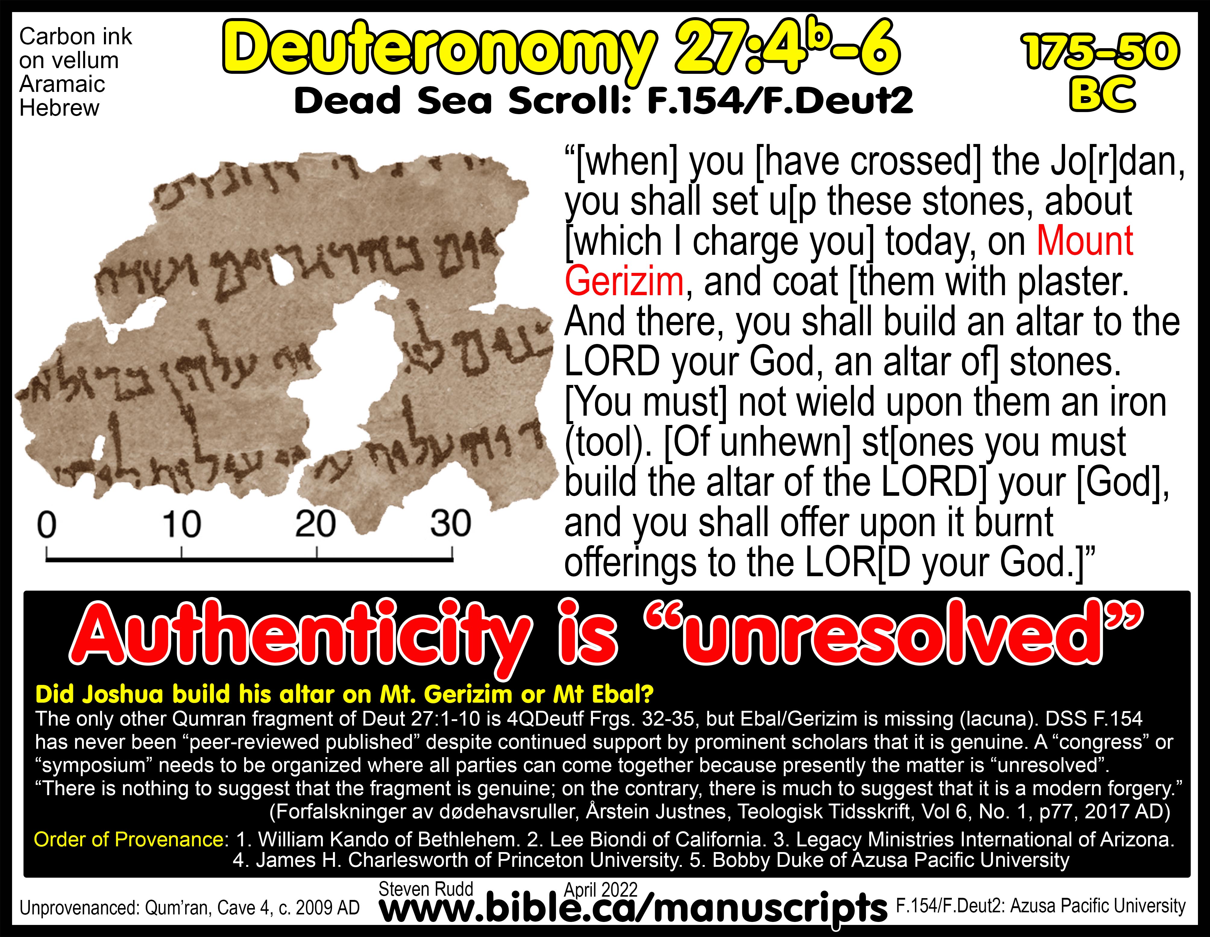
7. Warning—Possible forgery: Recently discovered Hebrew Dead Sea Scroll (4QDeut?) at Cave 4 in Qumran supports the ancient Samaritan view that Joshua built his altar on Mt. Gerizim, not Mt. Ebal.
|
|
Joshua’s Altar on Mt. Gerizim? See detailed outline on this Dead Sea Scroll from Qumran, cave 4, that reads “Gerizim” instead of “Ebal”. (4QDeut?)
While inherently speculative, the Samaritans may have built their Samaritan Temple on Mt. Gerizim to venerate Joshua’s Altar! |
A. Archaeology of Joshua’s Altar:
1.
Steven Rudd personally met Adam Zertal at the very site
of Joshua's Altar where he discussed the find under the watchful eye of an IDF
ground army escort including F-16s in November 2004. Trips are often thwarted
by the terrorists in the area. One ill-fated tour, in October 2000, ended with
the death of Rabbi Binyamin Herling, one of several hikers who left the main
route and were shot at by Palestinian terrorists in Shechem. The army was
widely accused of not taking offensive action to save the hikers when the
terrorists pinned them down with long-range but accurate fire. A later trip to
the same area during Chanukah was canceled by the army with just two days
notice, because of intelligence warnings of another planned terror attack. On
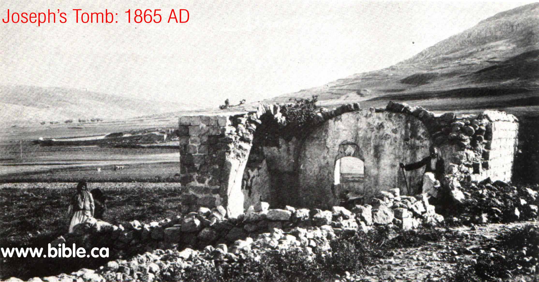
October 7, 2000, Joseph's Tomb, the third most holy place in Judaism, was
destroyed by Muslims. It is located east of modern Nabulus between Shechem (Tel
Balata) and Sychar at the foot of Mt. Ebal. It had come under attack and the
Israeli Defense Forces (IDF) withdrew after gaining reassurances from the
Palestinian Authority (PA) that they would protect the site in accordance with
their obligations under the Oslo Accords to protect holy sites. Two hours after
the withdrawal Muslims began destroying the site. Joseph’s Tomb was burned and
torn down stone by stone, then bulldozed. It was immediately declared a Muslim
holy site. I was extremely fortunate and privileged to be one of the first to
visit Joshua’s Altar in AD 2004, although the army did cut short my visit for
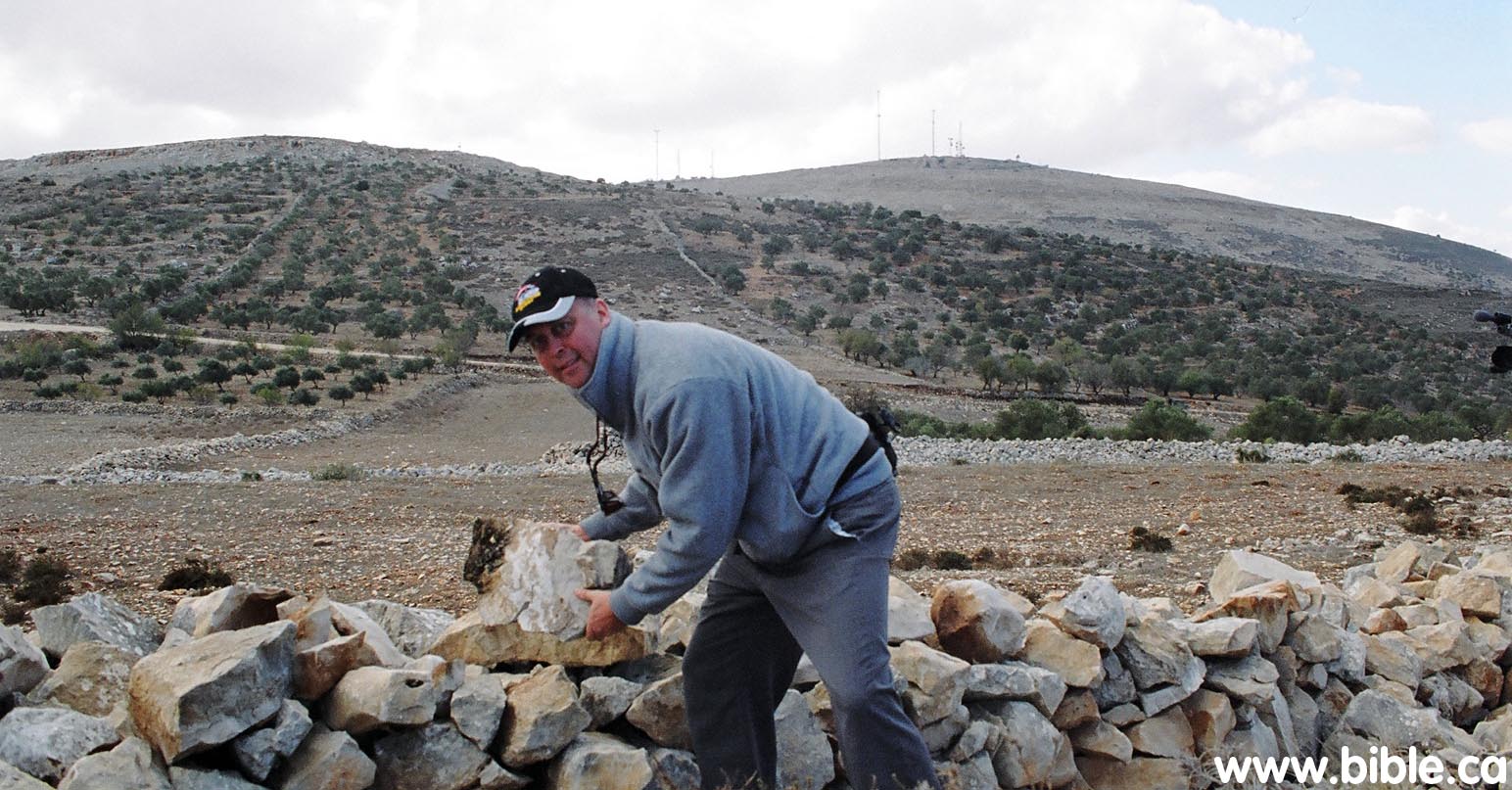
"security reasons". I also assisted in reconstruction of the outer
temenos wall of the altar under Adam Zertal’s personal supervision.
 .
.
2. In a discussion with Adam Zertal, he said that this archeological site has made a Bible believer out of him. Amen! Adam Zertal has undergone a transformation of faith that is truly remarkable. Like most of his fellow Israeli archeologists, he did not believe the Bible stories of the exodus to be true. He told me directly that the most anti-Biblical forces in archeology are the professors in the various Universities in Israel. Many Christians and Jews are surprised that this would be the case. Palestinian Muslims quote these Israeli archeologists in Tel Aviv as proof that the idea of a Jewish homeland that dates back to 1406 BC is a myth. Zertal was one of these Bible trashing archeologists. But that all changed in 1983, three years after Zertal first stumbled on the site while doing a formal archeological survey of the area. After studying the structure for three years with no idea what is was used for, he suddenly realized that it was the site of Joshua's Altar. We agree with him and now he believes the Bible. See our section on, "They are digging up Bible stories!"
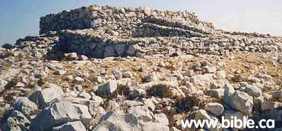
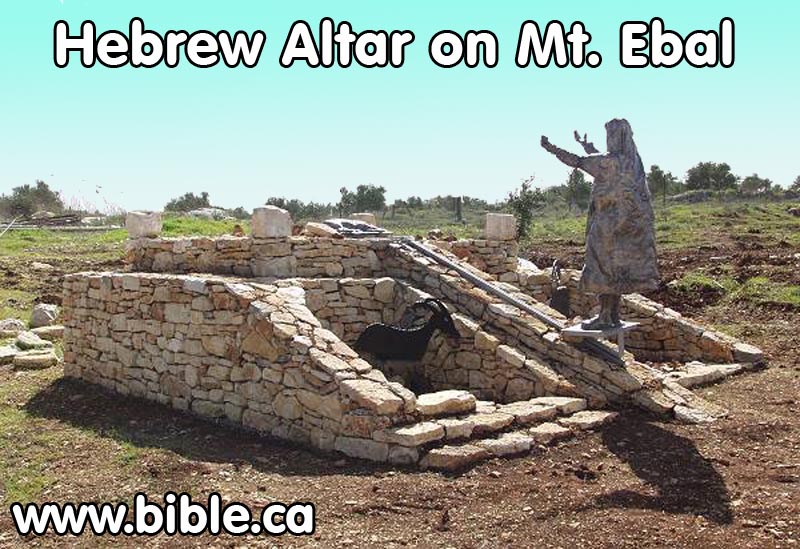
The Hebrew altar on Mt. Ebal as seen today. Reconstruction at Garden of
Biblical Samaria Park
3.
Adam Zertal commented: "We discovered this place, all
covered with stones, in April 1980. At that time I never dreamt that we were
dealing with the altar, because I was taught in Tel Aviv University - the
center of anti-Biblical tendencies, where I learned that Biblical theories are
untrue, and that Biblical accounts were written later, and the like. I didn't
even know of the story of the Joshua's altar. But we surveyed every meter of
the site, and in the course of nine years of excavation, we discovered a very
old structure with no parallels to anything we had seen before. It was 9 by 7
meters, and 4 meters high, with two stone ramps, and a kind of veranda, known
as the sovev, around."
4. The exodus happened in 1446 BC and the Pharaoh of the exodus was Tuthmoses III. However, there is a problem, because Adam Zertal dates the exodus at 1250 BC, when the Bible tells us it was 1446 BC. 1 Kings 6:1 says that Israel was at Joshua's Altar in 1406 BC. The structure we see today simply cannot be Joshua's altar since it is dated to 1250 BC.
5.
Zertal discovered a second circular structure 6.5 feet
in diameter underneath what we see today. Zertal dates this second structure to
1300 BC but we question this. We have superimposed the circle of stones onto
the drawing so you can see what it looked like. These stones were on bedrock
level underneath the altar we see today. We call this circle of stones an
"altar", although Zertal does not. However, he does document that
burnt bones found inside of it.
6. Hebrew altars can be distinguished from pagan altars in 5 respects: 1. They are made of uncut natural stone. 2. Ramps, never stairs. 3. Hebrew altars are square. 4. Hebrew altars have their sides oriented to the 4 points of the compass (NSEW), as we see in the orientation of the tabernacle. It is clear that Adam Zertal has discovered a Hebrew altar because it is made of uncut stones with ramps. However since the altar is rectangular and the corners, not the sides point NSEW, this site presents some challenges. We believe this mix of pagan and Hebrew elements of the rectangular altar of 1250 BC can be explained. This was the time of Deborah the Judge and perhaps this altar was built by Hebrews to worship to both YHWH and a pagan god. Perhaps the mix of Hebrew and pagan elements in the altar are typical of such times of compromise. "Then the sons of Israel did evil in the sight of the Lord and served the Baals, and they forsook the Lord, the God of their fathers, who had brought them out of the land of Egypt, and followed other gods from among the gods of the peoples who were around them, and bowed themselves down to them; thus they provoked the Lord to anger. So they forsook the Lord and served Baal and the Ashtaroth." Judges 2:11-13
7.
Adam Zertal refined his views of the two level of
occupations at the Mt. Ebal site. In 2004 Zertal dates the rectangular altar to
1250 BC. "More important, however, is that they
[the pottery discovered] fix a date for the construction of the altar -
approximately 1250 b.c.e." (Adam Zertal). In 1986: "Zertal
calls the older occupation "level II" which he dates 1225 - 1200 BC
and the younger level I to 1200 -1150 BC. Zertal also uncovered a raised step
behind the courtyards, which he assigns to Level II. "Animal bones from
Level II have been found in the area of the courtyards; these bones are not burnt
and thus are probably the remains of meals, not sacrifices. Cultic
installations in the area of the later altar are also attributable to this
early phase. In Level I (the later phase), many new structures were added
(tinted red). The Israelites constructed a thin stone wall parallel to the old
revetment wall. They filled in the space between the Level II revetment wall
and the Level I wall with medium-size stones to make a sturdy temenos wall that
supported the courtyards. At the same time, says Zertal, they built the altar.
Surrounding the inner temenos, the altar and the courtyards, an outer temenos
wall was constructed. Entrance to this larger walled area was from an opening
on the southeast. A three-stepped entrance from the west in the inner temenos
wall gave access to the altar area." (How Can Kempinski Be So Wrong!, Adam
Zertal, BAR, 1986 AD)
Since 2004, Zertal now dates level II to 1250 BC.
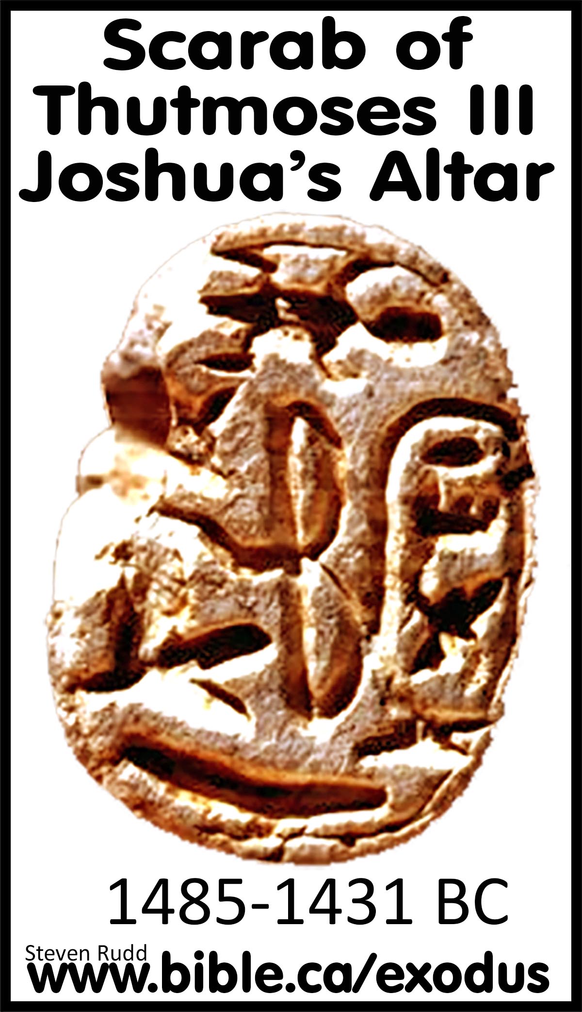
8. Amazingly, Zertal has already discovered the proof he needs to date the site to the 1406 BC. He discovered the cartouche of Tuthmoses III at the site. (see below). Tuthmoses III was the pharaoh of the exodus.
B. AD 2019 Mt. Ebal Curse Tablet: “Defixio” by Steven Rudd, March 2022
Earliest Hebrew inscription on Earth. | Earliest Hebrew use of YHWH on Earth
“That with an iron stylus and lead they were engraved in the rock forever!" (Job 19:24)
Introduction:
|
|
The AD 2019 discovery of the Late Bronze Age lead curse tablet on Mt. Ebal, which the Bible identifies as the mountain of curses, is a Bible skeptic’s worst nightmare because it is an alphabetic Proto-Paleo-Hebrew script that utilizes a complex and sophisticated chiastic poetic parallel with 10 curses, to express a legal verdict echoing Gen 2;17, “you shall surely die”, that includes God’s name “YHWH” twice, in the same format as a contemporary Late Bronze Age Hittite submission covenant, embedded like a sealed letter inside an folded outer envelope, in the same time, place, and message as would be predicted by scripture. “That with an iron stylus and lead they were engraved in the rock forever!" (Job 19:24) |
I. The importance of the AD 2019 Mt. Ebal Lead Curse Tablet:
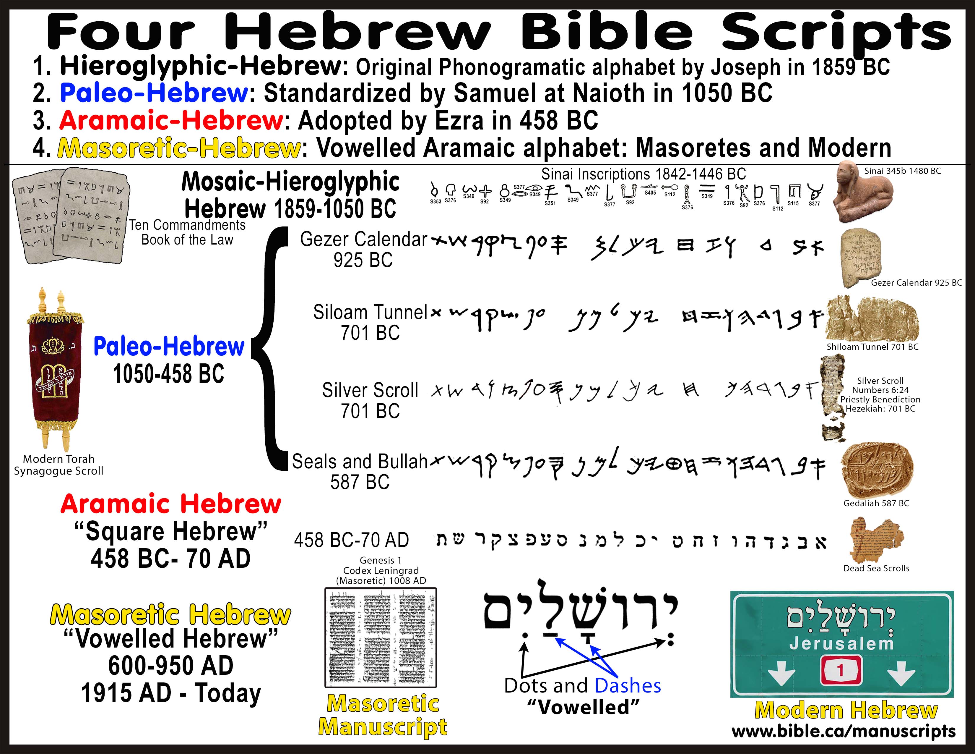
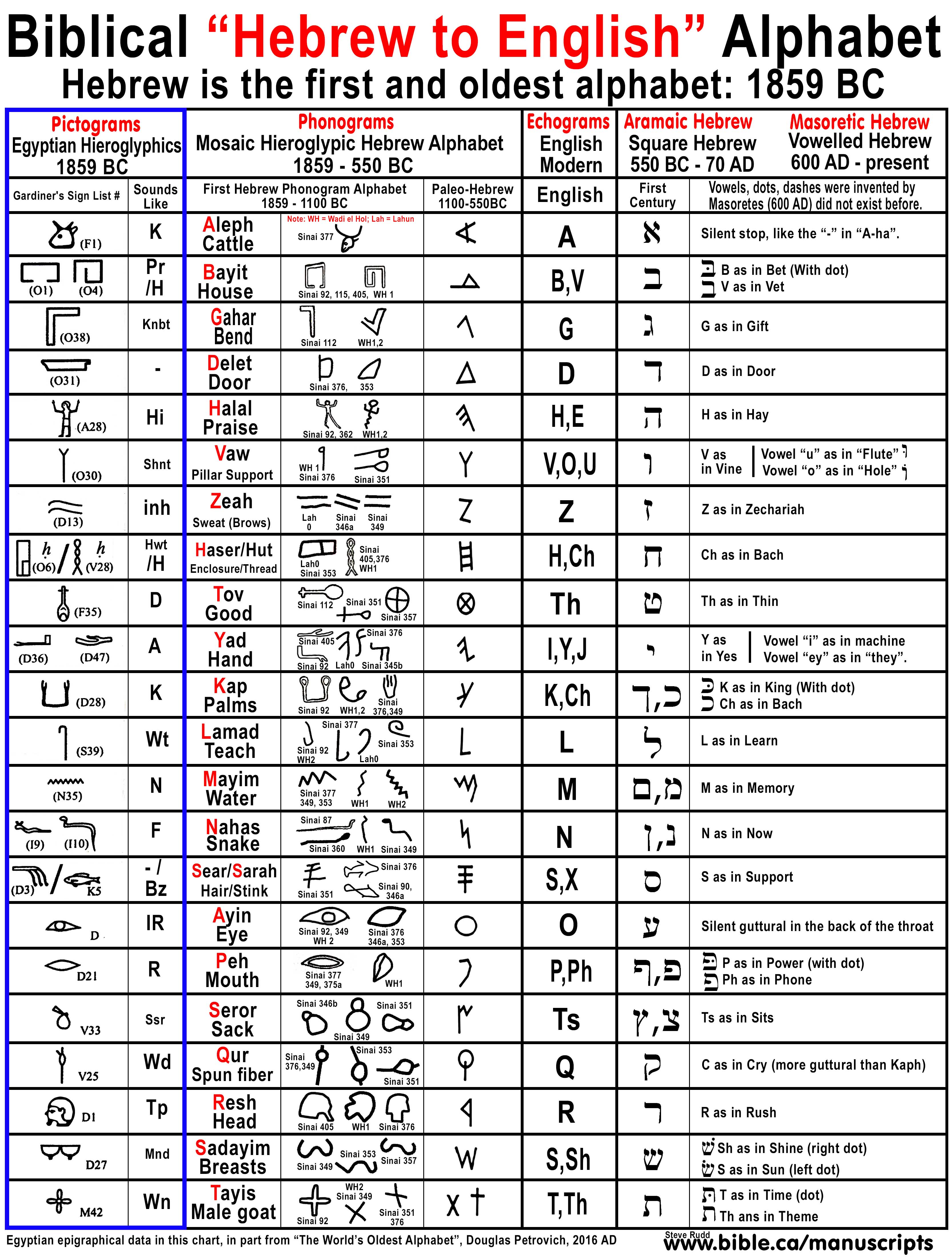
1. The script of the Mt. Ebal Lead Curse Tablet dates to the Late Bronze Age: 1406-1100 BC. Three key epigraphic features the script unquestionably date the Lead Curse Tablet of Mt Ebal to the Late Bronze Age as a proto-Paleo-Hebrew script.
a. First, the Hebrew letter “H” (halal/praise) is represented twice in the name of God (YWH) with the graphical symbol of a man with his hands raised over his head in worship which was directly borrowed from Egyptian Hieroglyphics.
b. Second, the Hebrew letter “A” (aleph) is represented 11 times using the graphical symbol of an ox head which was directly borrowed from Egyptian Hieroglyphics.
c. Third, the Hebrew text reads left to right, placing it in the period before 1100 BC, after which, the script became standardized reading right to left by Samuel through his work at his prophet’s school at Naioth around 1050 BC (1 Sam 19:18-24). The earliest Hebrew, Egyptian, and Phoenician scripts were read left to right, right to left, top to bottom, bottom to top, or as the ox plows.
2. Oldest
Hebrew text: There were four historic Hebrew scripts, and the lead curse
tablet is from the earliest family known as Hieroglyphic-Hebrew, also called,
Proto-Paleo-Hebrew. Joseph invented the first alphabet by adapting the symbols
from Egyptian Hieroglyphs as the basis of the 22 characters of the Hebrew
alphabet. It can be proven that all alphabets today, including English, were
directly derived from this original Hebrew alphabet. The transition from
Hieroglyphic-Hebrew to Paleo-Hebrew occurred under the oversight and direction
of Samuel at his prophet’s school Naioth around 1050 BC. It was Samuel who
standardized the Hebrew script used by David and Solomon down to the Babylonian
captivity when Paleo-Hebrew script went extinct. Under the oversight and
direction of Ezra in 458 BC, Aramaic Hebrew, also known as “Square Hebrew”
replaced the Paleo-Hebrew script. Aramaic Hebrew was the script of the Dead Sea
Scrolls and the script used today in modern Israel. The curse tablet predates
the oldest known Hebrew text by 200-475 years. Currently, the oldest Hebrew
script is from the Khirbet Qeiyafa ostracon which is dated to between 1010-923
BC.
|
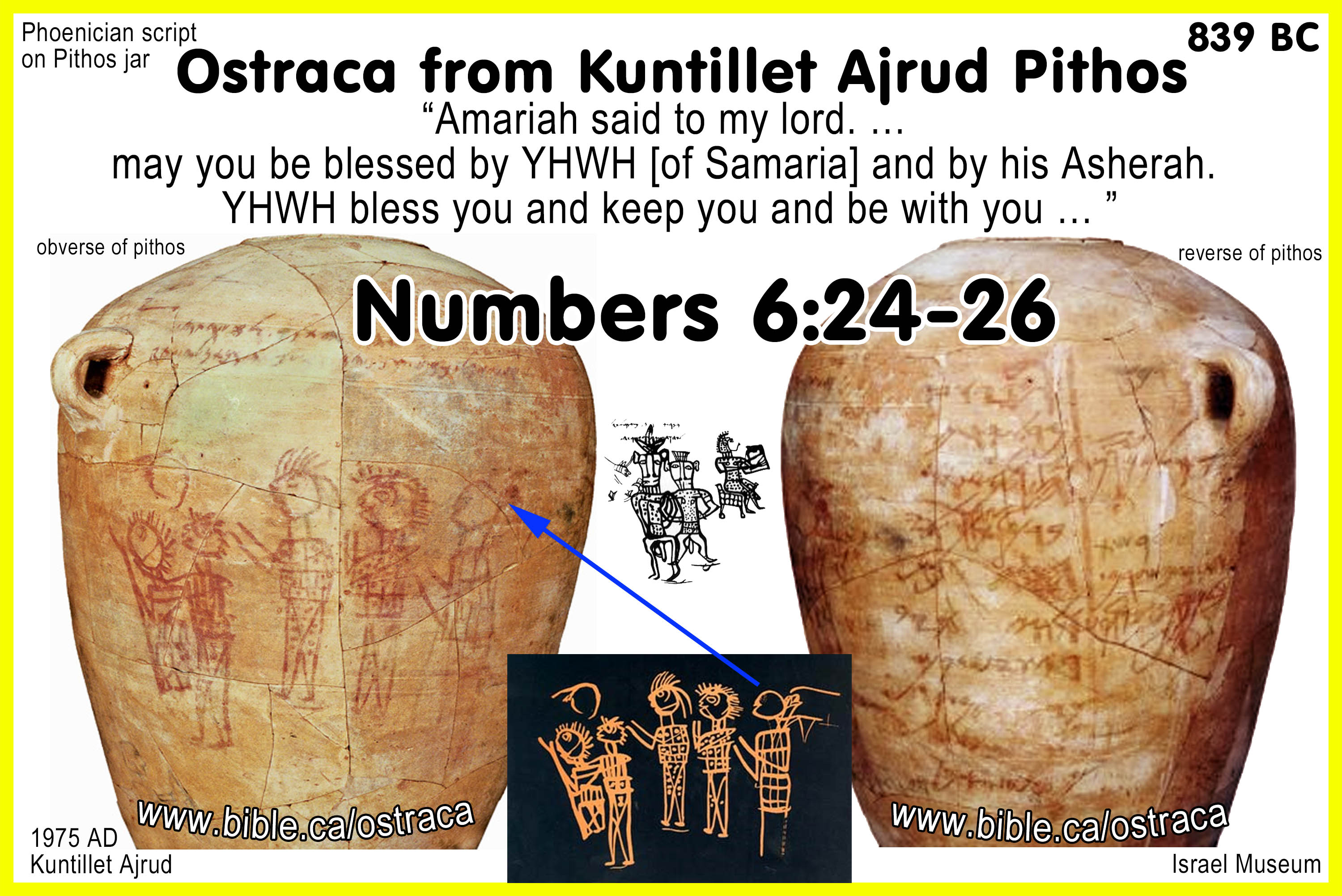
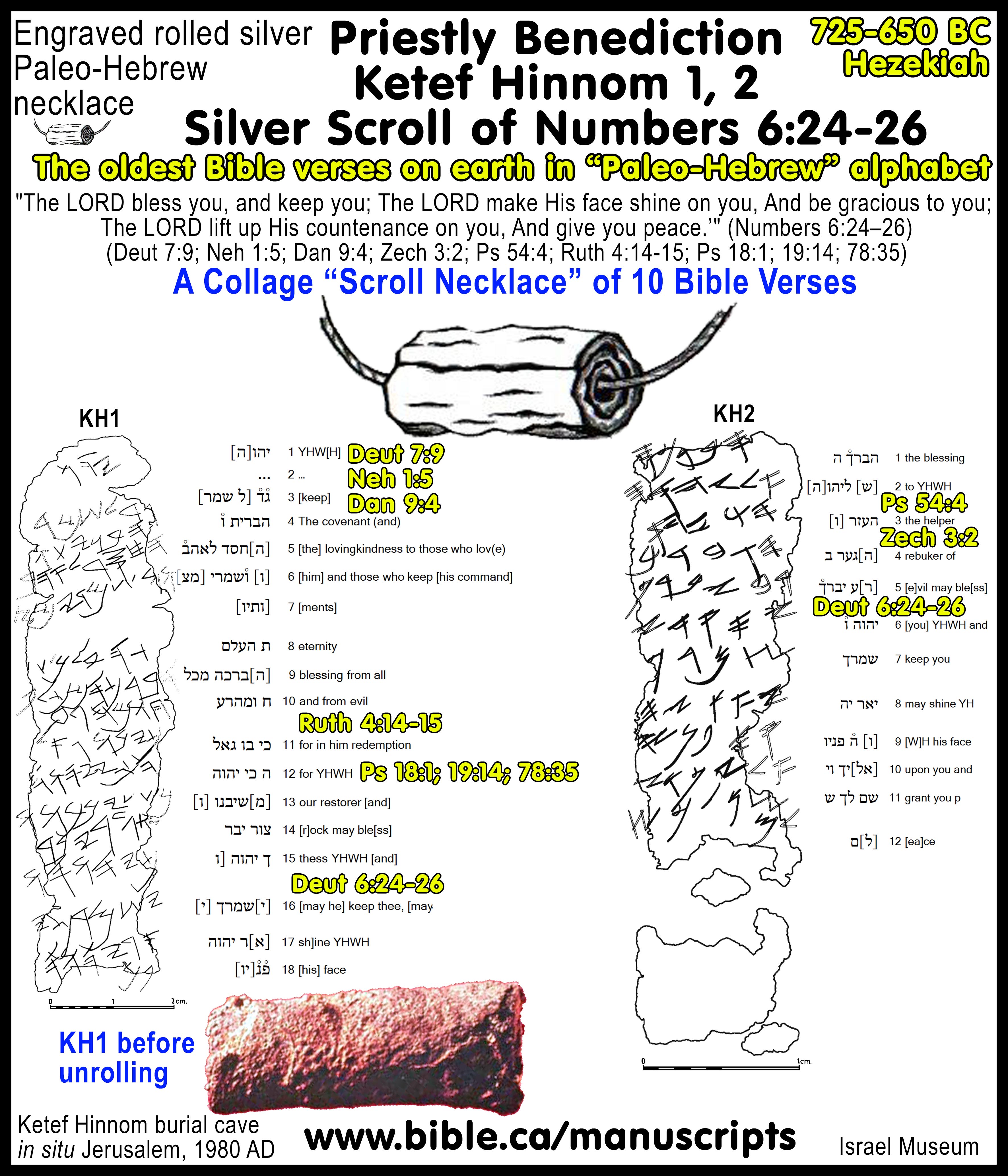
3. Oldest use of YHWH: Twice the curse table uses the three-letter “YHW” for the name of God. The curse tablet predates the oldest known Hebrew use of YHWH by 300-575 years. Currently, the oldest Hebrew text that contained YHWH, is the Kuntillet Ajrud ostracon which dates to 839 BC. Kuntillet Ajrud is currently the oldest Hebrew Bible text (Numbers 6:24-26) which predates the Ketef Hinnom silver scroll by 100-200 years. |
|
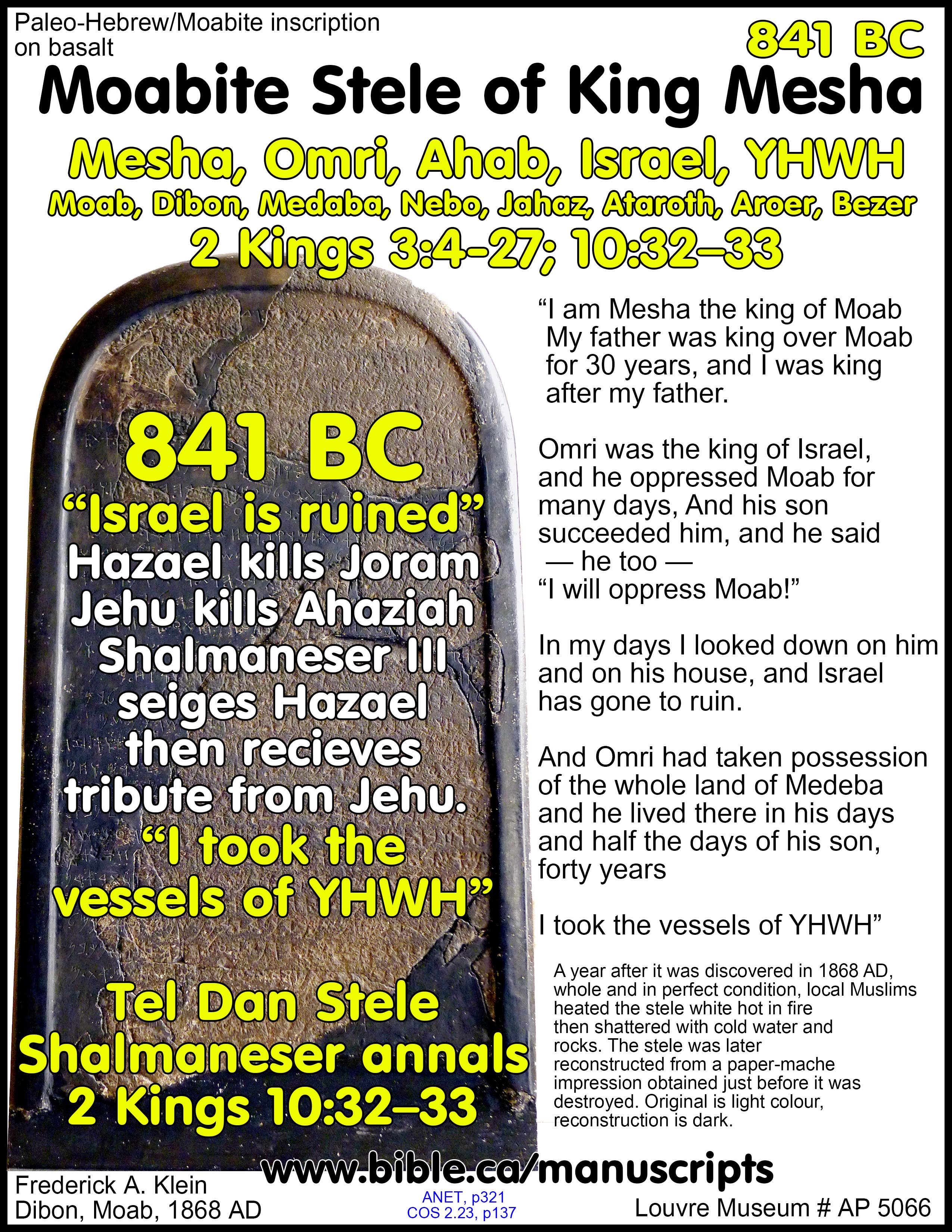
a. Four-letter spelling of YHWH:
i.
The common four-letter spelling “YHWH” used over 6500 times in scripture
is also used in the Moabite/Mesha Stele (841 BC). “I am Mesha the king of
Moab… Omri was the king of Israel, and he oppressed Moab for many days, And his
son Ahab) succeeded him, and he said “I will oppress Moab!” In my days (941 BC)
I looked down on him and on his house, and Israel has gone to ruin. … And
Chemosh said to me: “Go, take Nebo from Israel!” … I took it, and I killed
[its] whole population, seven thousand male citizens … And
from there, I took the vessels of YHWH” (Mesha Stone, 841 BC)
b. Two-letter: YH, YW
i. The two-letter spelling “YH” (Yah) is used in Exodus 15:2; 17:16; Ps 68:4,18
ii. The two-letter spelling “Yô or Yehô” is used in personal names like “Jochebed” meaning “Jehovah is glory” (Ex 6:20) and “Joshua” meaning ““Jehovah is salvation” (Ex 17:9)
iii. The double two-letter spelling “YH YH” is used in Isa 26:4
iv. The two and four-letter spelling used in combination “YH YHWH”: Isaiah 12:2; 26:4
v.
The two-letter spelling “YW” is used 9 or 10 times in the assemblage of
ostraca at Kuntillet ‘Ajrud (839 BC).
OLDEST BIBLE TEXT ON EARTH: Numbers 6:24-26. In AD 2017, Steven Rudd
identified from excavation reports, that the oldest bible verses ever
discovered was the from the assemblage of ostraca from Kuntillet Ajrud.
Currently the oldest Hebrew Bible text (Numbers 6:24-26) from Kuntillet Ajrud,
predates the Ketef Hinnom silver scroll by 100-200 years, which also quotes Num
6:24-25.
c. Three-letter spelling: YHW, YHH
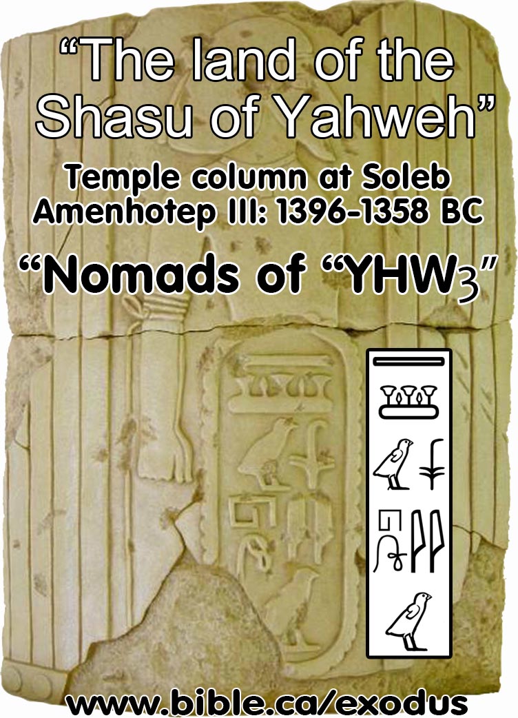
i.
The three-letter spelling YHW is used in Soleb temple: “Shasu of Yhw”:
1396-1358 BC
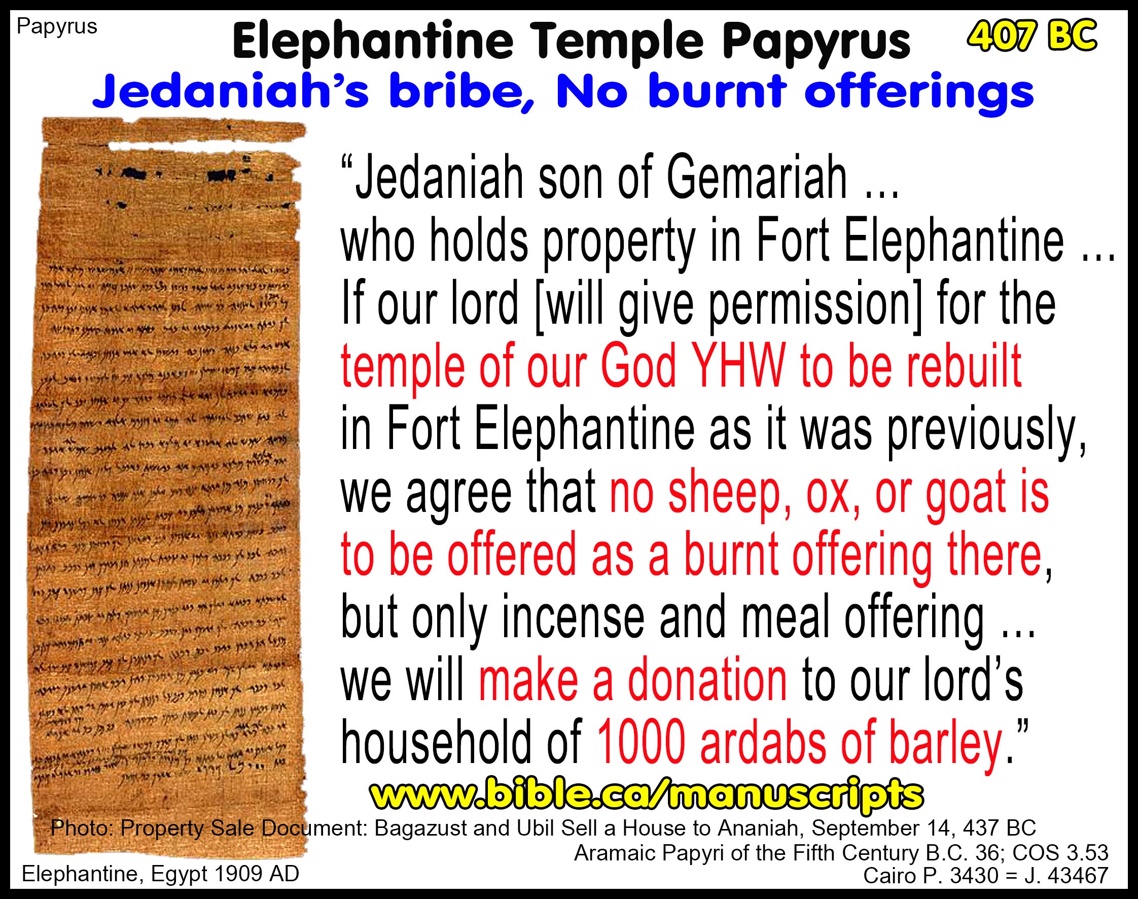
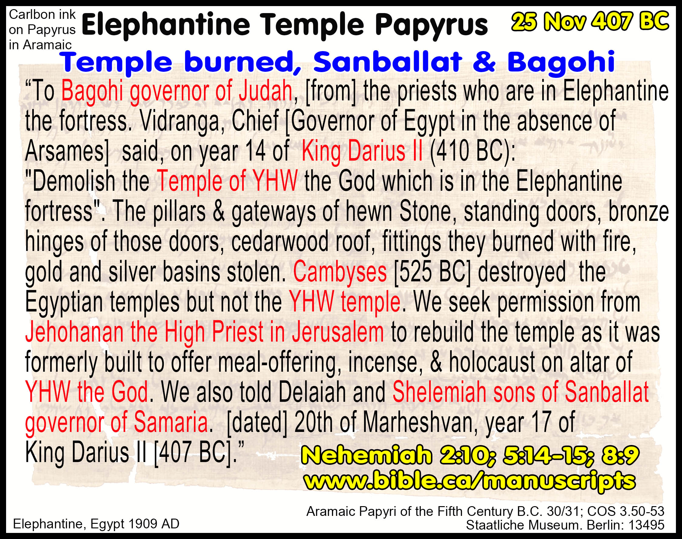
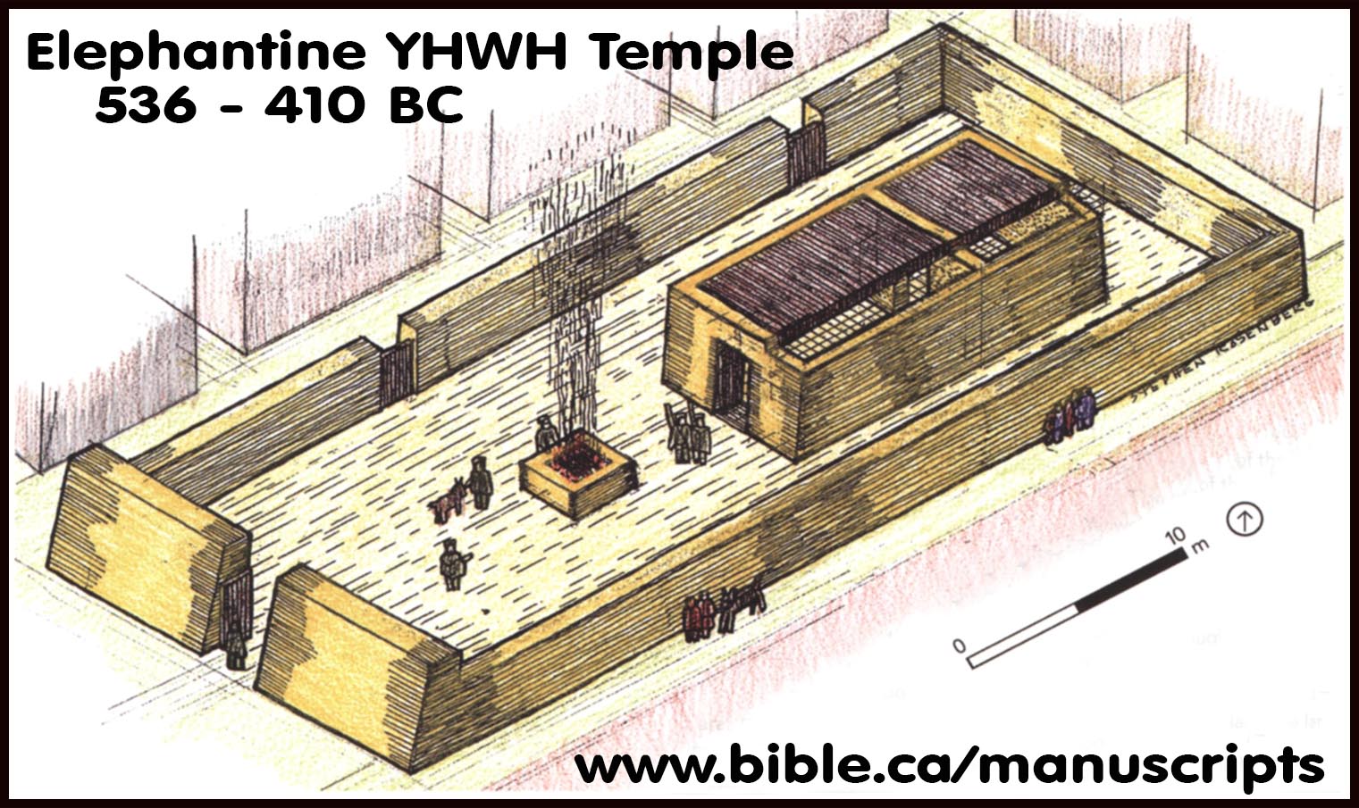
ii. The three-letter spelling “YHW” is used in the Aramaic Elephantine papyri: c. 400 BC
1. “YHW the God dwelling in Yeb.” (404 BC, Anani)
2. “Greetings to the temple of YHW at Elephantine” (Padua 1)
3. “Let us get rid of the temple of the God YHW in Fort Elephantine!” (“Text A” (AP 30)
4. “If our lord [will give permission] for the temple of our God YHW to be rebuilt 9in Fort Elephantine as it was previously, we agree that no sheep, ox, or goat is to be offered as a burnt offering there, but only incense and meal offering”. (AP 33, 407 BC)
iii. The three-letter spelling “YHH” is used in the Aramaic Elephantine papyri:
1. “Look after the tunic I left in the temple of YHH. Tell Uriyah it is to be dedicated.” (O. Cairo 49624, 475 BC)
2.
“May YHH [of hosts] bless you at all times.” (O. Clermont-Ganneau 186,
475 BC)
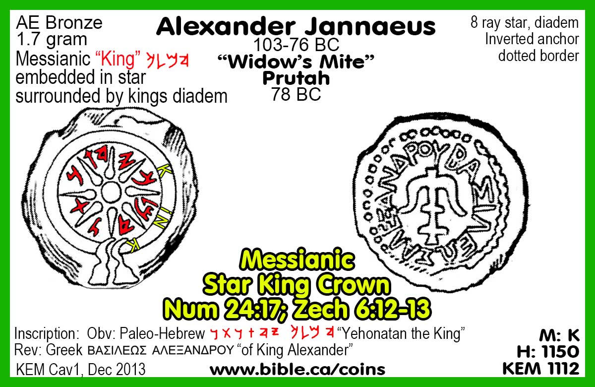
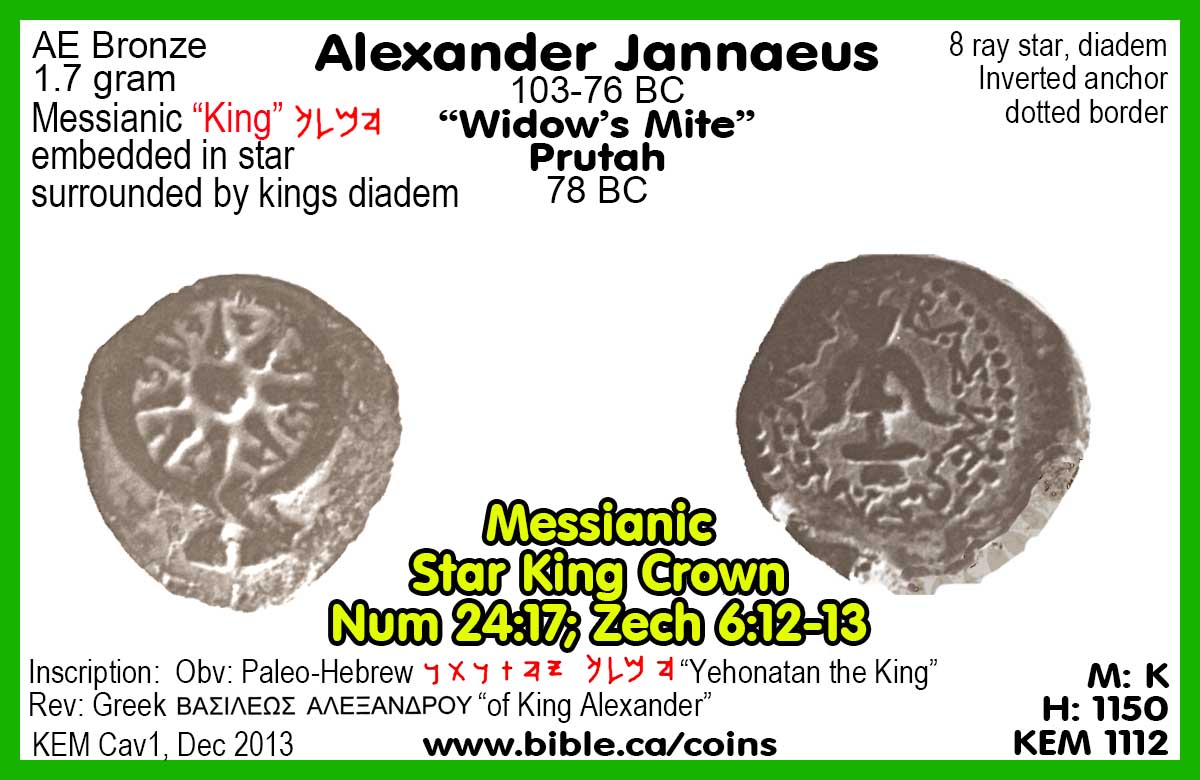
iv. Alexander Jannaeus used the three letter Paleo-Hebrew spelling “YHW” on his coins, 500 years after the Paleo-Hebrew script went extinct as a memorial of Israel’s beginning. His choice of the 3-letter spelling of the name of God in Paleo-Hebrew script confirms that it was considered a standard form.
1.
“Yehonatan the King” (78 BC). “Many of Jannaeus’ coins were overstruck
to replace “Yehonatan the King” with “Yonatan the High Priest and the Community
of the Jews,” eliminating both the royal title and the combination of letters
YHW, which could be read as the name of God. The restriking was probably done
after Jannaeus’ death, during the reign of Queen Salome Alexandra (76–67
B.C.).” (Dictionary of New Testament Background, Craig Evans, p223, 2000 AD)
4. The oldest lead curse tablet:
a. The metallurgy of the Mt Ebal Lead Curse Tablet dates to the Late Bronze Age matching 1406 BC. The metallurgy of the lead was analyzed at Hebrew university and was confirmed to originate from the famous Late Bronze Age Lavrion silver and lead mines in Greece from which many other lead objects are known to originate. The script on the Mt. Ebal curse tablet was inscribed with and Iron stylus on lead just as confirmed by the book of Job, where the story dates to the Early Bronze Age at the time of Abraham (Job 19:24; cf. also Jer 17:1).
a. Recently, Israeli archaeologists confirmed inscribed lead ingots were imported into Canaan from the Aegean region around 1400 BC, when they discovered in a ship’s cargo in a port south of Haifa. This lead has been analyzed and comes from the same Late Bronze Age Lavrion silver and lead mines in Greece as the Mt. Ebal curse tablet which dates to the same period.
b. Previously, the oldest known inscribed lead curse tablet was found in city of Selinus in Sicily which dated to the 5th century BC, which was a whopping 700-900 years younger than the Mt. Ebal lead curse tablet.
c. Previously, the oldest known inscribed lead strip was discovered in 1937 at the capital of the Hittite empire in central Anatolia in modern Turkey and dated to the 14th to 13th century BC.
5. Archeologically the Mt Ebal Lead Curse Tablet dates to the Late Bronze Age: 1406-1150 BC
a. The curse tablet was found in Zertal’s excavation dump of Joshua’s altar which he determined was abandoned around 1150 BC, dating the curse tablet earlier than 1150 BC.
|
b. Zertal discovered a scarab of Thutmoses III at Mt. Ebal in the earliest stratum II, but concluded the scarab was a ceremonial replica created during the reign of Ramses II who Zertal misidentified as the pharaoh of the exodus. Steven Rudd rejected the scarab was a replica in AD 2006, and redated Zertal’s stratum II from 1275 BC to 1446 BC, which is perfect synchronism for Thutmoses III as the Pharaoh of the exodus. It is expected that the Hebrews left Egypt in possession with his scarabs which they acquired during the 18 years he was their pharaoh before the exodus. |
|
“About 70 to 80 [circular] installations were uncovered to the north, south and east of the central complex. These consisted of crudely arranged stone-bordered circles, squares, or rectangles (and many irregular shapes) with an average diameter or width of 30 cm. to 70 cm. They are intermixed and built one upon the other in some cases. … Wall 17, which extends from the northern courtyard, and Wall 44, which joins curving Wall 22. This wall encompasses other installations, in one of which scarab No. 2 [Thutmoses III] was unearthed. The stratigraphical position of the scarab could not be fixed, because of the mixture of the Strata II and I installations, but its deep location hints at Stratum II.” (An Early Iron Age Cultic Site On Mount Ebal: Excavation Seasons 1982-1987 Preliminary Report, Adam Zertal, Tel Aviv, vol 14, p118, 1987 AD)
c. In AD 1985, Adam Zertal excavated an incense altar at Joshua’s altar in stratum II. In the AD 1906, Flinders Petrie excavated a similar sandstone incense and libation altars from the Hathor temple at Serabit el-Khadim which Petrie dated to the Late Bronze Age and identified as of Semitic (i.e. Hebrew) origin. Hebrews worshiped Hathor/Ashtaroth the cow goddess at Serabit el-Khadim and as the golden calf at Mt. Sinai in 1446 BC. In 586 BC the Jews offered libations to Hathor as the “queen of heaven” (Jer 44:19.) In AD 2016, Douglas Petrovich identified a series of Hebrew “Sinai Inscriptions” at Serabit el-Khadim that he dated to the time of the exodus. Although Zertal never tested the origin of the pumice, it may have been from the Thera eruption, which Manfred Bietak (excavator of Goshen at Tel el-Dab’a) dated to the time of Thutmoses III using low Egyptian chronology. To complete the circle of evidence, Zertal used Petrie’s sandstone chalice as a parallel for the Mt. Ebal chalice in his exaction report. “Pumice chalice. This vessel was placed in Pit 250 before the Stratum LB fill was poured and therefore dates to Stratum II. It is 10 cm. high and the diameter of the base - and upper bowl is 8.5 cm. The bowl is 3 cm. deep.” (Adam Zertal excavation report of Joshua’s altar, 1985 AD) During the exodus, Moses camped at Succoth on the Gulf of Suez, at a location which is directly adjacent the turquoise mines of Serabit el-Khadim to pick up the Hebrew slaves who worked there. In AD 2006, Steven Rudd redated Zertal’s stratum II from 1275 BC to 1406 BC because both the scarab of Thutmoses III and the pumice incense altar were excavated from stratum II.
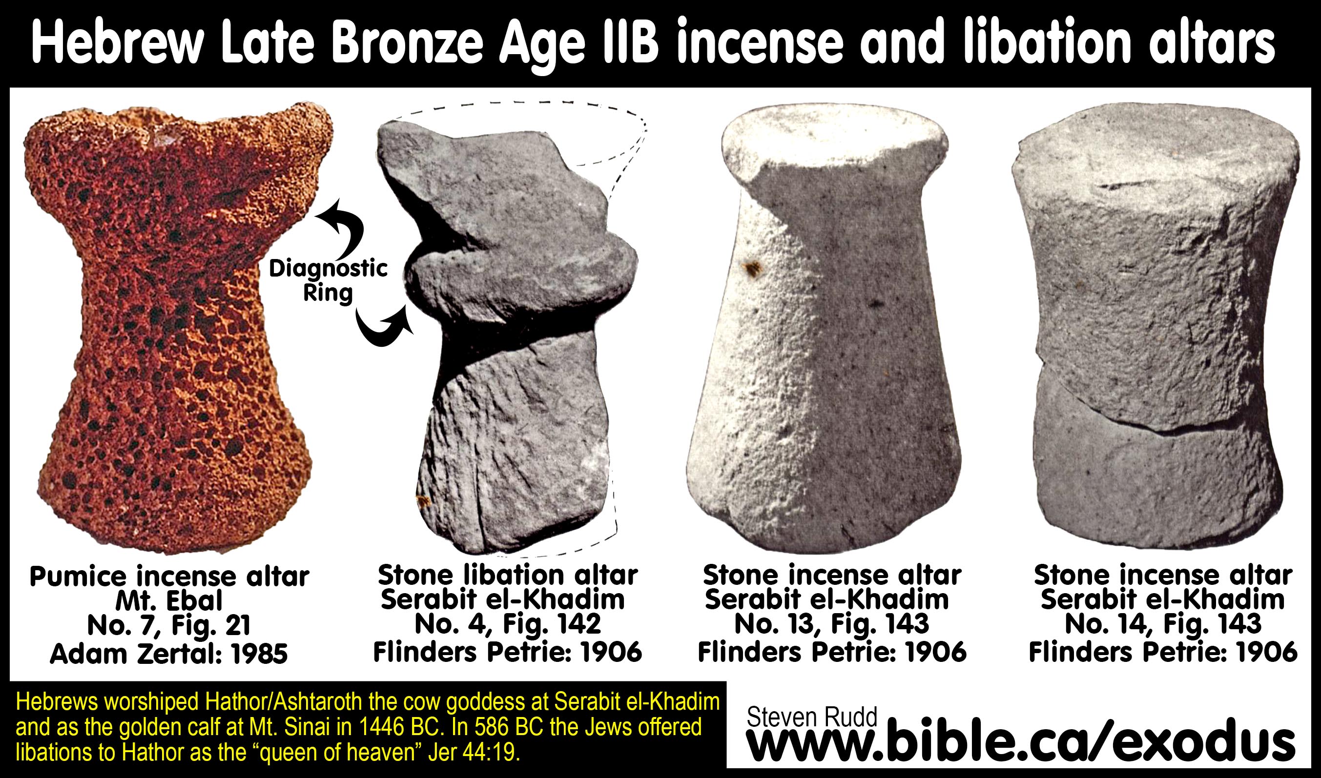
“The plainest and roughest of the altars were nos. 14 and 15, which were found in the Portico; no. 15 has been merely rough-chipped, no. 14 has been dressed over. The altar no. 13 is well finished, and on the top the surface was burnt for about a quarter of an inch inwards, black outside and discoloured below. This proves that such altars were used for burning; and from the small size, about 5 to 7 inches across, the only substance burnt on them must have been inflammable, such as incense. This altar is a foot high; it was found in the shrine of Sopdu and is now in the British Museum. A larger and more elaborate Altar (no. 4) was found in the Sacred Cave. It has been much broken about the top, but it had originally a basin hollow about 9 inches wide and 4 inches deep which might perhaps have been for libations [liquid offerings]. Around the narrowest part is a thick roll 4½ inches high. The whole altar is 25 inches high. … Most of these altars seem to be intended for incense, and in one case there is the mark of burning on the top; they thus agree with what we know of the Jewish system, where a small altar was reserved specially for incense. We have here, then, another instance of Semitic worship, differing from that of Egypt, where incense was always offered on a shovel-shaped [stone] censer held in the hand.” (Researches in Sinai, Flinders Petrie, p133, 1906 AD)
6. Confirms scripture that Mt. Ebal was Mountain of curses: The curse tablet confirms that Mt. Ebal was the mountain of curses, which agrees with the Masoretic Text, the Samaritan Pentateuch, and the Septuagint.
7. Confirms the early Exodus date of 1446 BC: The tablet provides strong evidence that the early date of the exodus in 1446 BC is correct, and the late date of 1253 BC is wrong.
8. The “Documentary Hypothesis” of Bible skeptics refuted:
a. The lead tablet confirms that sophisticated writing skills using an alphabetic script existed at the time of Moses. The lead tablet dismantles and collapses the “Documentary Hypothesis” of Bible scoffers, who say that scribes wrote different portions of Pentateuch centuries apart and that the Pentateuch as we have it today, did not exist before 600 BC. The epigraphic skill of the lead curse tablet scribe was more than sufficient to write the entire Pentateuch, proving such writing skills existed at the time of Moses in the Late Bronze Age. “Documentary Hypothesis” advocates cannot now argue with a straight face that the ability to write scripture did not exist until the Persian or Hellenistic period. The author of the text was not only a scribe, but he was a theological leader. The curse table used both El and YWH together in the Late Bronze Age, contra the Documentary Hypothesis. It’s time for these skeptics to join the toddlers Sunday School class and learn the Bible in a true light of faith.
9. Sophisticated chiastic parallelism collapses the “Documentary Hypothesis”: The message reads the same, top to bottom and bottom to top. “Ciasm” is a Latin transliteration of the Greek chiasma (χιασμα) referring to the Greek letter Χ (chi). Chiasm is the repetition of the same elements in inverted order: a-b-b´-a´; or if a middle element is present: a-b-c-b´-a´. Chiastic arrangement, conceived graphically, resembles the letter Χ. Caism is used extensively throughout scripture (Eccl 1:12–2:26; 4:1–16; 5:8–6:9).
a. Examples of Caism are common scripture (many also in Psalms)
The King’s Experiment Ecclesiastes 1:12–2:26
A: Work Is an Evil Business, 1:12–15
B: Wisdom Brings Trouble, 1:16–18
C: Examining Pleasure, 2:1–11
B′: Testing Wisdom, 2:12–17
A′: Studying Toil, 2:18–23
Toil for Self and in Community Ecclesiastes 4:1–16
A: The Oppressed Abandoned, 4:1–3
B: Toil in Competition? Be Content! 4:4–6
C: Toil for No Purpose, 4:7–8
B′: Toil Alone? Work Together! 4:9–12
A′: The Oppressed Wise Youth Abandoned, 4:13–16
Enjoyment Instead of Greed Ecclesiastes 5:8–6:9
A: No Satisfaction in Wealth, 5:8–12
B: Wealth Is Easily Lost, 5:13–17
C: Best to Find Good in One’s Work, 5:18–20
B′: God Gives Wealth, But It Is Lost, 6:1–6
A′: Little Satisfaction in Toil, Pleasure, Wisdom, 6:7–9
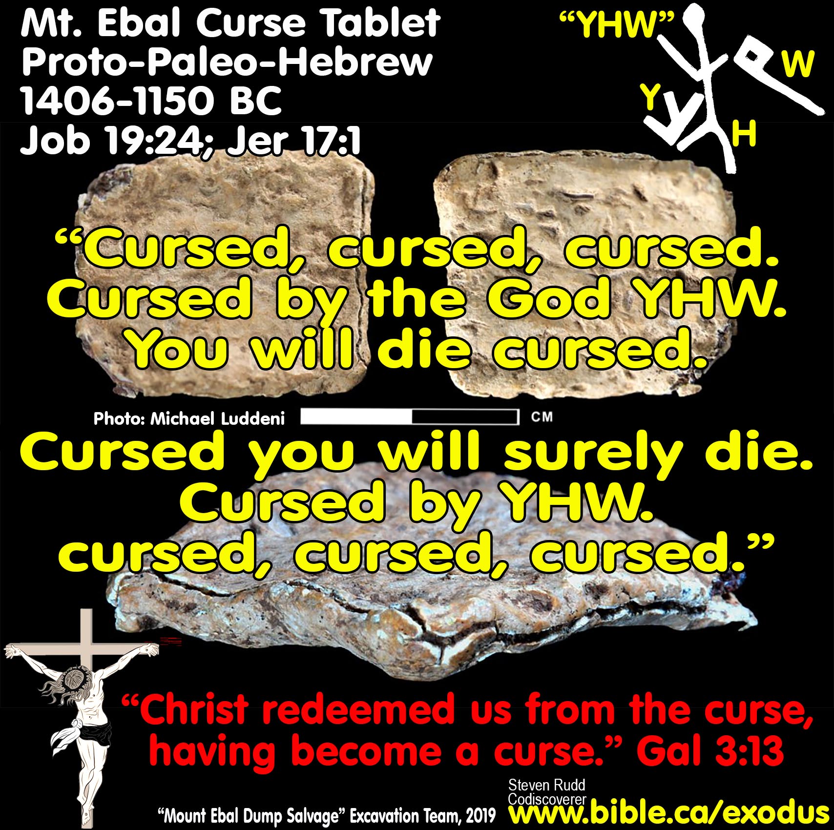
b. Caism in the 2019 Lead Curse Tablet of Mt. Ebal:
A: Cursed, cursed, cursed.
B: Cursed by the God YHW.
C: You will die cursed.
C’: Cursed you will surely die.
B’: Cursed by YHW.
A’: Cursed, cursed, cursed.
II. Hittite Submission (Suzerainty) Covenants and the Deuteronomy covenant:
The 2019 Lead Curse Tablet of Mt Ebal synchronizes with both account of the Bible covenant renewal ceremony in Joshua 8, and contemporary Hittite covenant ceremonies. Hittite submission covenants (suzerainty treaties) are known from the 1600 – 1200 BC and often contained 8 standard sections or parts. However, the order varied greatly even with the same Hittite ruler. Many treaties omit some of the 8 parts and/or invert the order of the parts and the document often ended with the curses and blessings as the last part. Notably, the curses are always followed by the blessings as they are in Deuteronomy 27-28. That Moses wrote Deuteronomy in the exact form of a contemporary 8 part Hittite covenant is not surprising since he was educated for 40 years as crown prince of Egypt in all military, economic and political matters (Acts 7:22). It is certain, therefore, that Moses had read many of these common covenants and likely even composed them for newly conquered vassal states of Egypt. Deuteronomy represents a summing up of all the events from Egypt to the shores of the Jordan River into a formal legal document to bring the Hebrews into covenant with God. Since the literary structure of Deuteronomy and the curse tablet, exactly follow the form and content of these the many extant Hittite Suzerainty treaties, this provides strong evidence Deuteronomy was written before 1200 BC and not 600 BC. It is certain that the Hebrews were familiar with these 8 part Hittite covenants since Moses forbad the Hebrews from forming these covenants with foreign nations (Ex 23:32; Deut 7:2; Judges 2:2). Instead of forming submission covenants with the nations, the Hebrew were only permitted to form an 8 point covenant with God alone. It is not surprising that the book of Deuteronomy is organized into the known format of an 8 part covenant:
1. Preamble: Deut 1:1-5
a. Hittite covenants often began by introducing the law-giving King under whom vassals were required to submit backed by the authority of the gods.
b. In the Deuteronomy covenant, Moses is introduced as the supreme lawgiver and authority on earth on behalf of God, who delivers the “Law of Moses” to the people.
c. Preamble of the 10 commandments: Ex 20:1; Deut 5:1
2. Historical survey: Deut 1:6—4:43.
a. Generally following the “preamble”, Hittite covenants recounted the historical interaction between the king and his conquered vassals.
b. In the Deuteronomy covenant, the exodus and conquest were recounted before they crossed the Jordan.
c. Historical survey of the 10 commandments: Ex 20:2; Deut 5:2-5
3. Law: Deut 5—26.
a. As their central purpose, all Hittite covenants contained a set of laws that vassals were required to obey.
b. In the Deuteronomy covenant the Law of Moses included the Ten Commandments and the ordinances in the Book of the Law.
c. The law of the 10 commandments: Ex 20:3-17; Deut 5:6-21
4. Divine witness: Deut 4:26; 28:58; 30:19; 31:28; 32:1 + 31:19–21
a. Immediately preceding the oath of curses and blessings, Hittite covenants often contained a long list of pagan gods who “shall stand and listen to the oath and be witnesses” to the covenant.
i. “The Storm-god, Lord of Heaven and Earth, the Moon-god and the Sun-god, the Moon-god of Harran, heaven and earth, the Storm-god, Lord of the kurinnu of Kahat, the Deity of Herds of Kurta, the Storm-god, Lord of Uhushuman, Ea-sharri, Lord of Wisdom, Anu, Antu, Enlil, Ninlil, the Mitra-gods, the Varuna-gods, Indra, the Nasatya-gods, the underground watercourse(?), Shamanminuhi, the Storm-god, Lord of Washshukkanni, the Storm-god, Lord of the Temple Platform(?) of Irrite, Partahi of Shuta, Nabarbi, Shuruhi, Ishtar, Evening Star, Shala, Belet-ekalli, Damkina, Ishhara, the mountains and rivers, the deities of heaven, and the deities of earth. They shall stand and listen and be witnesses to these words of the treaty/covenant.” (Treaty covenant between Shattiwaza of Mittanni and Suppiluliuma I of Hatti: 1344–1322 BC, A rev. 54–58, Hittite Diplomatic Texts, Gary M. Beckman, Harry A. Hoffner, Vol 7, p52, 1999 AD)
b. In the Deuteronomy covenant, Moses identified the divine witness: “respect this honored and awesome name: YHWH your God”. In addition to YHWH being the central covenant maker in the Deuteronomy covenant, Moses also calls upon “Heaven and earth”, (all creation: men and angels) as a witness. Finally, God said the Song of Moses would be taught and remembered by Israel forever as a witness between the Hebrews and God.
c. The Divine witness of the 10 commandments: Ex 20:2a,18,22; Deut 5:6a,22
d. The 2019 Lead Curse Tablet of Mt Ebal as a legal text, twice named “El YHWH” as the God who witnessed the oath of curses.
5. Curses and blessings ceremony: Deut 11:29; Chapters 27-30
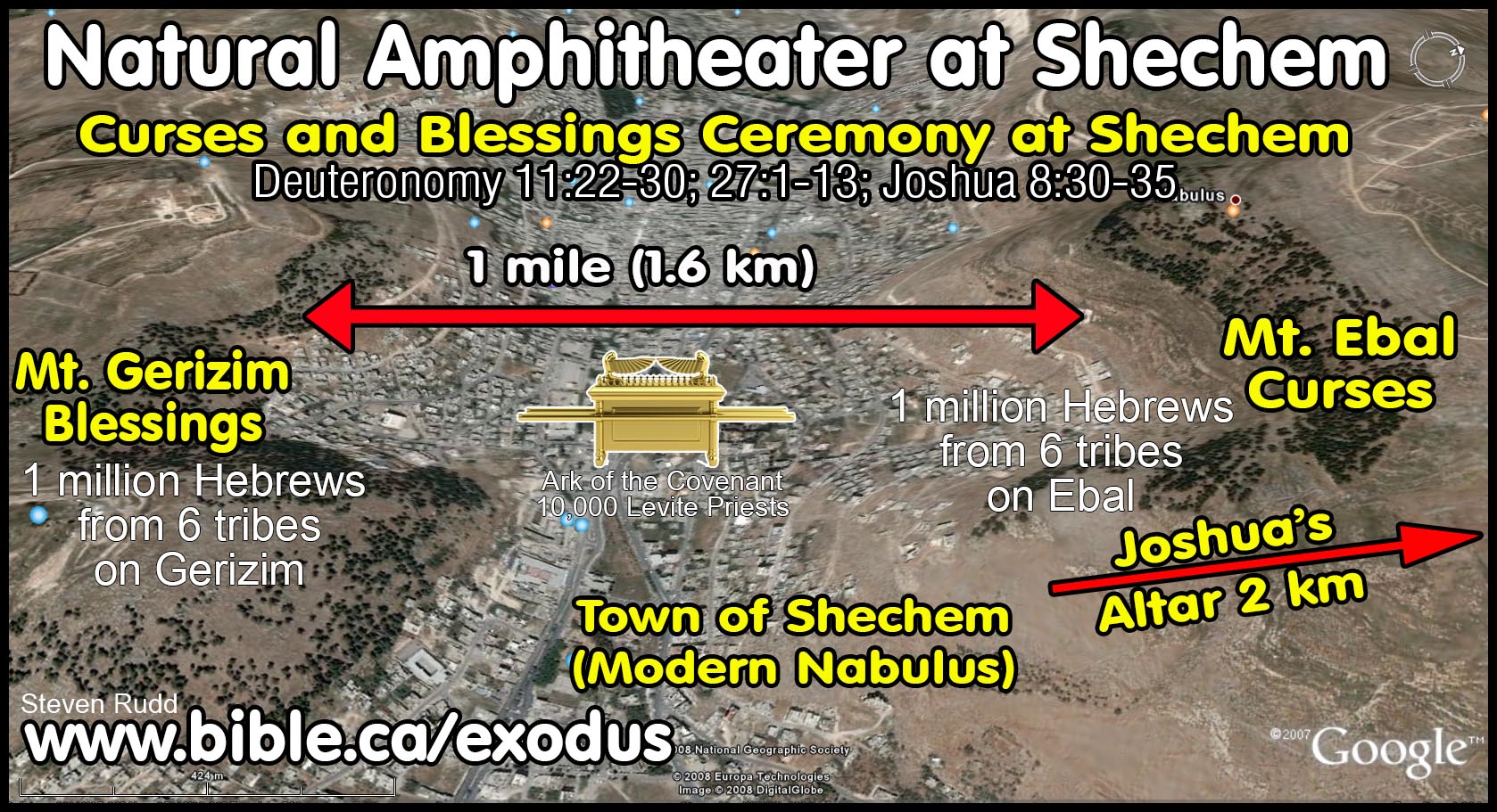
a.
Both Hittite covenants and Deuteronomy covenants required individuals to
swear a self-imprecatory submission oath of curses and blessings, meaning, the
vassal condemned himself to death if he broke the covenant. If you kept the
law, you were blessed by the gods and if you broke the law the gods must curse
you according to the oath spoken from your own lips. There is a natural
acoustic amphitheater between Mt. Ebal and Mt. Gerizim with a 1 km valley in
the middle. 1 million Hebrews from six tribes stood on the amphitheater slopes
of Mt. Gerizim for the curses, as did the other six tribes on Mt. Ebal for the
blessings. In the valley was the tabernacle tent with Moses and the priests.
The estimated 10,000 (Num 3:39) Levitical priests spoke in unison as one voice,
each of the twelve curses to the six tribes standing within the natural
amphitheater on Mt. Ebal and they replied “amen” after each. Then the remaining
six tribes standing within the natural amphitheater on Mt. Gerizim said “amen”
to the 12 blessings. There are many other examples of self-imprecatory curses
in scripture (Job 31:21–23; 1 Sam 25:22).
i. 1344–1322 BC: Treaty covenant between Suppiluliuma I of Hatti and Huqqana of Hayasa: This treaty had two sets of blessing and curses in the body and the end of the document. The first set were curse + blessings like Deuteronomy 27/28 and the document ended with second set (not included herein) in reverse order: blessings + curse. Curses: (A ii 1) “and if you do not tell me about him, but even [hide] him. (A ii 2–9) or go over to him, abandoning My Majesty—if you act thus, these oath deities will not leave you alone, nor on your account will they leave alone that man to whom you go over. They shall destroy him. And the oath gods shall not neglect this matter in regard to both of you, and they shall not make it permissible for both of you. They shall destroy both of you together and thereby fulfill the wishes of My Majesty.” Blessings: (A ii 10–13) “But if you, Huqqana, protect only My Majesty and take a stand only behind My Majesty, then these oath gods shall benevolently protect you, and you shall thrive in the hand of My Majesty.” (Hittite Diplomatic Texts, Gary M. Beckman, Harry A. Hoffner, Vol 7, p29, 1999 AD)
ii. 1344–1322 BC: Treaty covenant between Suppiluliuma I of Hatti and Aziru of Amurru: Curses: (A rev. 12′–16′) “All the words of the treaty and of the oath which are written] on this tablet—if Aziru does not observe these words of the treaty and of the oath, but transgresses the oath, then these oath gods shall destroy Aziru, together with his person, his wives, his sons, his grandsons, his household, his city, his land, and his possessions.” Blessings: (A rev. 17′–20′) “But if Aziru observes these words of the treaty] and of the oath which are written on this tablet], then these oath gods shall protect Aziru, together with his person, his wives, his sons, his grand-sons, his household, his city, his land, and his possessions. [end of document]” (Hittite Diplomatic Texts, Gary M. Beckman, Harry A. Hoffner, Vol 7, p36, 1999 AD)
iii. 1344–1322 BC: Treaty covenant between Shattiwaza of Mittanni and Suppiluliuma I of Hatti: Curses: (rev. 25–34) “If you, Shattiwaza, and you Hurrians do not observe the words of this treaty, these gods of the oath shall destroy you, Shattiwaza, and you Hurrians, together with your land, together with your wives, together with your sons, and together with your possessions. They will draw you out like malt from its husk. As one does not get a plant from … —if you, Shattiwaza,—so you together with any other wife whom you might take (in place of my daughter), and you Hurrians, together with their wives and their sons, shall thus have no progeny. And these gods, lords of the oath, shall allot you poverty and destitution. And they shall overthrow your throne, Shattiwaza. And you, Shattiwaza—these oath gods shall snap you off like a reed, together with your land. Your name and your progeny by another wife whom you might take shall be eradicated from [the earth]. And you, Shattiwaza, together with your land, because of not delivering goodness and recovery(?) among the Hurrians—you(!) shall be eradicated. The ground shall be ice, so that you will slip. The ground of your land shall be a marsh of … , so that you will certainly sink and be unable to cross. You, Shattiwaza, and you Hurrians shall be the enemies of the Thousand Gods. They shall defeat you.” Blessings: (rev. 35–39) “If you, Shattiwa, and you Hurrians observe this treaty and oath, these gods shall protect you, Shattiwaza, together with the daughter of the Great King of Hatti, her sons and grandsons, and you Hurrians, together with your wives and your sons, and together with your land. And the land of Mittanni shall return to its previous state. It shall prosper and expand. And you(!), Shattiwaza, your sons and grandsons by the daughter of the Great King, King of Hatti—they shall accept you(!) for kingship for eternity. Prolong the life of the throne of your father; prolong the life of the land of Mittanni.” (Hittite Diplomatic Texts, Gary M. Beckman, Harry A. Hoffner, Vol 7, p52, 1999 AD)
iv. 1321-1295 BC: Treaty covenant between Mursili II of Hatti and Manapa-Tarhunta of the Land of the Seha River: Curses: (A iv 29′–39′) “And if you, Manapa-Tarhunta, together with the people of the land of the Seha River and the land of Appawiya, do not observe these words, and in the future, to the first and second generation, you turn away, or you alter these words of the tablet—whatever is contained on this tablet, then these oath gods shall eradicate you, together with your person, your wives, your sons, your grandsons, your household, [your land], your infantry, your horses, your chariots(?), and together with your possessions, from the Dark Earth.” Blessings: (A iv 40′–46′) “But if you, Manapa-Tarhunta, observe these words of the tablet, and in the future you do not turn away from the King of Hatti, together with my sons, and from the word of the oath, then these oath gods shall benevolently protect you. And your sons shall thrive in the hand of My Majesty.” (Hittite Diplomatic Texts, Gary M. Beckman, Harry A. Hoffner, Vol 7, p86, 1999 AD)
b. Twelve curses and blessings of Mt. Ebal and Mt Gerizim in Deut 27-28: 1. Cursed/Blessed in the city and country. 2. Sterile/Fertile women. 3. Drought/Plentiful crops. 4. Sterile/Fertile livestock. 5. Famine/Abundant bread and grain. 6. Cursed/Blessed coming in and going out. 7. Defeated/Defeat enemies. 8. Ridiculed/Established as God's holy people. 9. Fear, mental illness, insanity, disease/Healthy, feared by other nations. 10. Powder & dust/Plentiful rain. 11. Borrow/Lend to other nations. 12. Tail/head to other nations.
c. The curses and blessings of the 10 commandments: Ex 20:5b,6,7b,12; Deut 5:9b,10,11,16,33. Oath: Deut 5:27
d. Since the 2019 Lead Curse Tablet of Mt Ebal was a legal text of a covenant, there must have been a corresponding set of blessings. Although unrelated, the Numbers 6:24 silver blessings scroll was found at Ketef Hinnom in AD 1980. There are 10 curses in the curse tablet but 12 curses in Deut 27. The “10” curses may symbolize universal completeness or echo the number of the 10 commandments.
e. Isaiah recited 10 woes again the Hebrews in Isa 3:9-10:1
f. Jesus recited 8 curses (woes) against the scribes and Pharisees, and 9 blessings (Mt 5; 23).
6. Succession: Deut 31—34
a. Hittite covenants required vassals and their descendants to continue to obey the succeeding sons of the Hittite kings. Succession clauses generally preceded the oath of curses and blessing, but in the Deuteronomy covenant the succession clauses came after the oath.
b. The Deuteronomy covenant had dual succession clauses where both Joshua and Moses were two different antitypes of Jesus. First, Joshua succeeded Moses as physical leader, but not a lawgiver (Deut 31:14-23; 34:9). Second, Jesus succeeded Moses as the messianic spiritual leader and lawgiver of the New Covenant (Deut 18:18; Acts 3:22; 7:37; Heb 8:6).
c. The succession of the 10 commandments (God to Moses): Ex 20:19; Deut 5:25-27
d. The Law of Moses was in force continually from 1446 BC until it was abolished by being nailed to the cross on 3 April AD 33, then it was replaced by the Law of Christ (Col 2:14; 1 Cor 9:21; Gal 6:2).
7. Depository of duplicate copies: Deut 10:2; 31:24–30
a. In Hittite covenants, the original copy was deposited in the Hittite sanctuary and a duplicate copy was deposited in the vassal’s sanctuary.
i. “A duplicate of this tablet is deposited before the Sun-goddess of Arinna, since the Sun-goddess of Arinna governs kingship and queenship. And in the land of Mittanni a duplicate is deposited before the Storm-god, Lord of the kurinnu of Kahat.” (Treaty covenant between Suppiluliuma I of Hatti and Shattiwaza of Mittanni: 1344–1322 BC, A rev. 35–53, Hittite Diplomatic Texts, Gary M. Beckman, Harry A. Hoffner, Vol 7, p52, 1999 AD)
b. In the Deuteronomy covenant the formal textual object of the “old covenant” was the ten commandments written by the finger of God on stone and placed in the Ark of Covenant where God dwelt, with access forbidden for all except the high priest (Deut 5:2-3; 9:9-11; Ex 34:27-28; 1 Ki 8:9+21). While the original “sealed copy” of the stone tablets covenant was in the Ark, a second papyrus “open copy” of the ten commandments was placed beside the Ark, which was brought outside the Tabernacle and made available for any Hebrew to read.
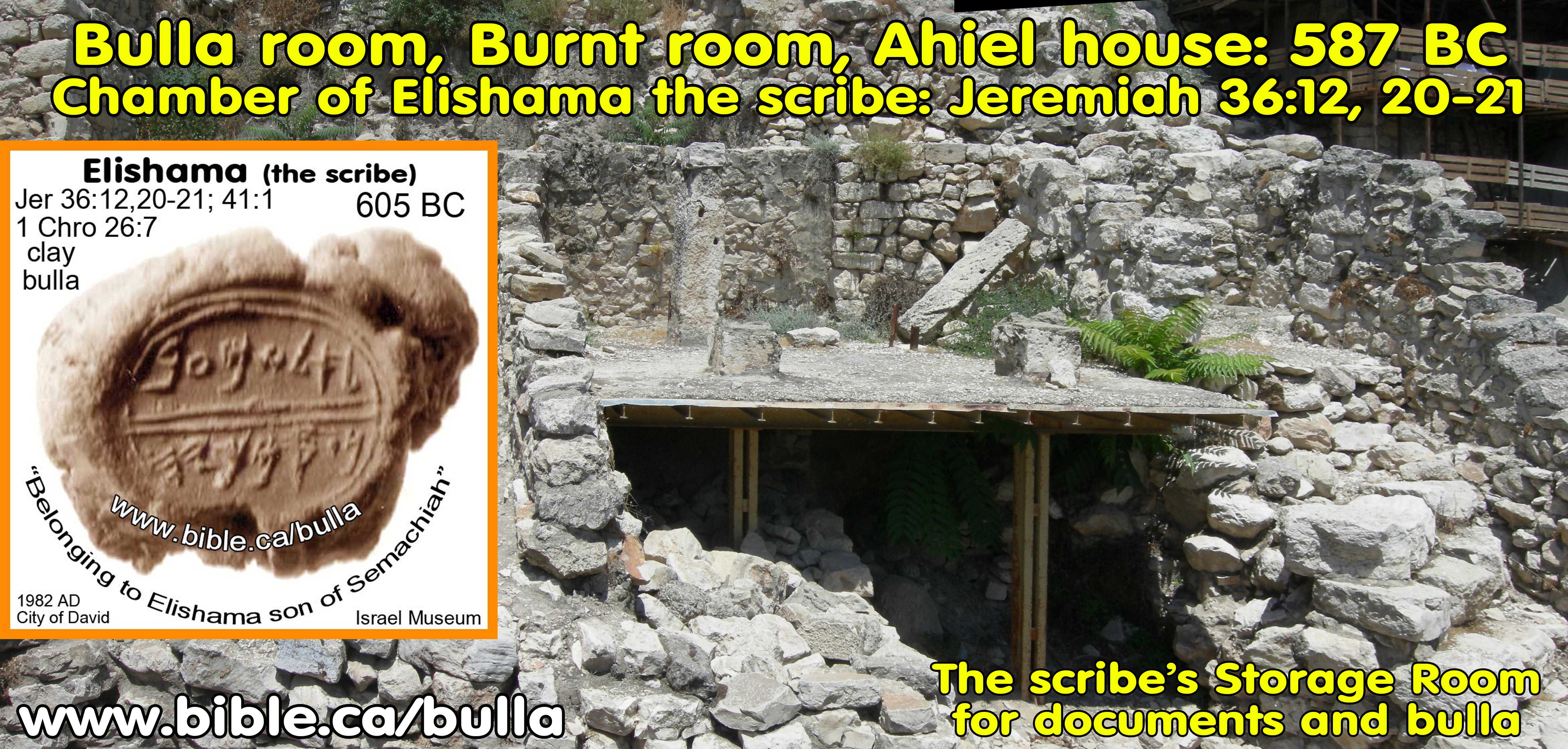
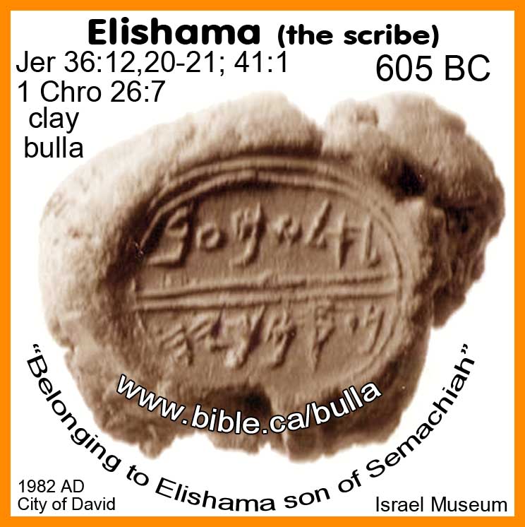
c.
This exactly mirrored how duplicate copies of Jeremiah’s “Deed of Land”
where deposited in the royal document chamber of Elishama the scribe in
Jerusalem (Jer 32:9-14). The “sealed copy” was inside the vault secured with
string and clay bulla seals, and the “open copy” was in the viewing room
adjacent to the vault for all to read. If a legal dispute occurred, and someone
challenged that the words of the open copy were different from the words of the
sealed copy inside the fault, they would call the officials who would open the
fault, break the seals of the original document, and compare it with the open
copy. In AD 1982, excavations in the City of David discovered both this official
document room of Elishama and his bulla (Jeremiah 36:20). What you read in the
book you find in the ground.
d. The depository of the 10 commandments: God gives tablets of stone to Moses: Deut 5:22
e. The 2019 Lead Curse Tablet of Mt Ebal was a sealed official legal document that was never intended to be opened. The lead tablet resembled an envelope with text on the outside and a folded sealed letter inside.
8. Public readings: Deut 6:7–9; 11:18-21; 17:18-20; 31:19-30
a. In Hittite covenants, the text was to be annually read to the vassal king and his people forever.
i. “It shall be read repeatedly, for ever and ever, before the king of the land of Mittanni and before the Hurrians.” (Treaty covenant between Suppiluliuma I of Hatti and Shattiwaza of Mittanni: 1344–1322 BC, A rev. 35–53, Hittite Diplomatic Texts, Gary M. Beckman, Harry A. Hoffner, Vol 7, p52, 1999 AD)
b. In the Deuteronomy covenant, YHWH went one step further and required the king to write a copy of the law with his own hand and always keep it with him to read daily. The Hebrews had to write out the law on their doorposts, gates, hands, foreheads, and memorize the song of Moses. All this demonstrates the high literacy rate of the Hebrews where man, women and child could all read and write.
c. The public readings of the 10 commandments: Expectation that children will be taught: Ex 20:5; Deut 5:9;29
d. The 2019 Lead Curse Tablet of Mt Ebal demonstrates the exceptional literary skills at the time of Moses. It also proves that there was an alphabetic script with which Moses and Joshua could have written the earliest biblical books.
Conclusion: Only through Jesus can we escape the curse:
1. The Mt. Ebal Lead Curse Tablet reveals the nature of God and our chose of curse or blessings!
2. Serpent was cursed. Sinners are cursed. Hell is the final curse.
3. Joshua’s Altar was on mountain of curses where atonement was needed. Expiated from the curse comes through the blood of Christ. Become a Christian to escape the final curse.
|
|
"Christ redeemed us from the curse of the Law, having become a curse for us—for it is written, “Cursed is everyone who hangs on a tree”— in order that in Christ Jesus the blessing of Abraham might come to the Gentiles, so that we would receive the promise of the Spirit through faith." (Galatians 3:13–14) |
By Steve Rudd, March 2022: Contact the author for comments, input or corrections.
C. The history of Shechem, Mt. Ebal and Mt. Gerizim:
- Today, ancient Shechem is located Tel Balata, which is about 3 km east of modern Nabulus. It may be that Tel Balata which literally means "a paving stone or tile" may in fact derive from Arabic balut, meaning "oak".
- In 2085 BC Abraham
left Haran at age 75 and the same year God appeared to him at Shechem: Gen
12:4. In 2085 BC, Abraham built an altar in Shechem beside the Oak of Moreh where God appeared to him and
promised to give his seed the land: "Abram passed through the land as
far as the site of Shechem, to the oak of Moreh.
Now the Canaanite was then in the land. The Lord appeared to Abram
and said, "To your descendants I will give this land." So he built an altar there to the Lord who had appeared
to him." Genesis 12:6-7. Regarding the "Oaks
of Moreh": Not just a single oak tree but a forest called the
"oaks of Moreh" were located
near, but not in Shechem, (Genesis 35:4) and apparently not directly on
either of the two mountains: "Are they [Mount Gerizim & Ebal] not
across the Jordan, west of the way toward the sunset, in the land of the
Canaanites who live in the Arabah, opposite Gilgal, beside the oaks of Moreh?" Deuteronomy
11:29-30. The location of the oaks of Moreh are clearly outside the formal
city limits of Shechem: "Then Hamor the father of Shechem went out to Jacob to speak with him." Genesis
34:6
- In 1900 BC, Jacob after he had fled from Laban back to Canaan, he built an altar at the place he camped "before the city of Shechem", not in Shechem. He bought this land: "Now Jacob came safely to the city of Shechem, which is in the land of Canaan, when he came from Paddan-aram, and camped before the city. He bought the piece of land where he had pitched his tent from the hand of the sons of Hamor, Shechem's father, for one hundred pieces of money. Then he erected there an altar and called it El-Elohe-Israel." Genesis 33:18-20
- In 1900 BC, just before Jacob moved from Shechem to Bethel, he hid the idols of his family under the "oak of Moreh" which was the very spot where Abraham had built an altar: "So they gave to Jacob all the foreign gods which they had and the rings which were in their ears, and Jacob hid them under the oak which was near Shechem." Genesis 35:4
- In 1883 BC, Joseph was sold into slavery. Jacob sent Joseph to Shechem to find his brothers, who had moved on to Dothan, where they betrayed him: "Israel said to Joseph, "Are not your brothers pasturing the flock in Shechem? Come, and I will send you to them." And he said to him, "I will go."" Genesis 37:13
- Joshua lived 1460 - 1350 BC: Joshua is described as a young man, a youth and was about 20 years old when Israel left Egypt in 1446 BC: (Ex 33:11; Num 11:28). Joseph was called "a youth" at age 17: Genesis 37:2. Joshua was chosen by Moses to fight Amalek at (Exodus 17:9) Rephidim. It is truly remarkable that a 20 year old was given the responsibility of leading the armies of Moses. Since the exodus was 1446 BC and Joshua lived to be 110 years old. (Joshua 24:29) This means Joshua was born about 1460 BC and died 1350 BC. This means that Joshua began serving Moses at age 20, and served Moses for 40 years in the wilderness and then 50 years in Canaan after crossing the Jordan.
- In 1406, when Israel crossed the Jordan, the tabernacle was first set in the Gilgal (Josh 4:19).
- In 1390 BC, Joshua traveled from Gilgal, where the tabernacle was located, to Mt. Ebal beside Shechem to built the "altar of Joshua". The ark of the covenant was taken to Mt. Ebal and used in the blessings and curses ceremony, while the tabernacle remained at Gilgal. Josh 8:30
- In 1385 BC, the tabernacle then moved to Shiloh (Josh 18:1,10) where he divided up the land by lot (Joshua 19:51). Shiloh was the central gathering point for Israel at the time of Joshua: "When the sons of Israel heard of it, the whole congregation of the sons of Israel gathered themselves at Shiloh to go up against them in war." Joshua 22:12.
- In 110 AD, Josephus says that the tabernacle was first at Gilgal, then Shiloh after which Joshua built the Altar on Mt. Ebal. The correct order was Gilgal, Ebal, Shiloh: "The fifth year was not past, and there was not one of the Canaanites remained any longer, excepting some that had retired to places of great strength. So Joshua removed his camp to the mountainous country, and placed the tabernacle in the city of Shiloh, for that seemed a fit place for it, because of the beauty of its situation, until such time as their affairs would permit them to build a temple; and from thence he went to Shechem, together with all the people, and raised an altar where Moses had beforehand directed; then did he divide the army, and place one half of them on Mount Gerizim, and the other half on Mount Ebal, on which mountain the altar was; he also placed there the tribe of Levi, and the priests. (And when they had sacrificed, and denounced the [blessings and the] curses, and had left them engraved upon the altar, they returned to Shiloh. (Josephus, Antiquities 5.1.19, 68-70)
- In 1385, Shechem became a central "city of refuge" for Ephraim and Manasseh: "They gave them Shechem, the city of refuge for the manslayer, with its pasture lands, in the hill country of Ephraim, and Gezer with its pasture lands," Joshua 21:21 (Josh 20:2,7; 1 Chronicles 6:67)
- In 1380, From Shiloh, Joshua sent the tribe of Reuben transjordan for their inheritance: Joshua 22:9. The sons of Reuben built an exact replica of the altar of burnt offering in the tabernacle at Shiloh on the east side of the Jordan which created a huge problem. Altars had to be endorsed directly by God or else they were considered apostate and rebellious: "Thus says the whole congregation of the Lord, 'What is this unfaithful act which you have committed against the God of Israel, turning away from following the Lord this day, by building yourselves an altar, to rebel against the Lord this day?" Joshua 22:16 "Therefore we said, 'It shall also come about if they say this to us or to our generations in time to come, then we shall say, "See the copy of the altar of the Lord which our fathers made, not for burnt offering or for sacrifice; rather it is a witness between us and you." '" Joshua 22:28
- In 1360 BC Just before Joshua died, the tabernacle "sanctuary of the Lord" was moved from Shiloh to Shechem and placed near the Oaks of Moreh. Joshua gathered all the people there for his farewell address: "Then Joshua gathered all the tribes of Israel to Shechem, ... and they presented themselves before God." (Joshua 24:1). He also set up a memorial stone directly underneath the very oak that Abraham had built an altar near and Jacob had hid his family idols underneath: "So Joshua made a covenant with the people that day, and made for them a statute and an ordinance in Shechem. And Joshua wrote these words in the book of the law of God; and he took a large stone and set it up there under the oak [of Moreh] that was by the sanctuary of the Lord. Joshua said to all the people, "Behold, this stone shall be for a witness against us, for it has heard all the words of the Lord which He spoke to us; thus it shall be for a witness against you, so that you do not deny your God." Then Joshua dismissed the people, each to his inheritance." Joshua 24:25-28
- In 1360 BC, Joshua died and was buried at Timnath-serah: Josh 24:30. At the same time Joseph, who had died in Egypt 440 years earlier (1800 BC), was buried at Shechem in a plot of land Jacob had bought 540 years earlier (1900 BC): "Now they buried the bones of Joseph, which the sons of Israel brought up from Egypt, at Shechem, in the piece of ground which Jacob had bought from the sons of Hamor the father of Shechem for one hundred pieces of money; and they became the inheritance of Joseph's sons." Joshua 24:32; Genesis 33:18-20; Acts 7:16.
- Today, the tomb of Joseph is located east
of modern Nabulus between Tel Balata and Sychar: "one of the tombs
whose location is known with the utmost degree of certainty and is based
on continuous documentation since biblical times. (Zvi Ilan, Tombs of the
Righteous in the Land of Israel, p. 365)
 .
.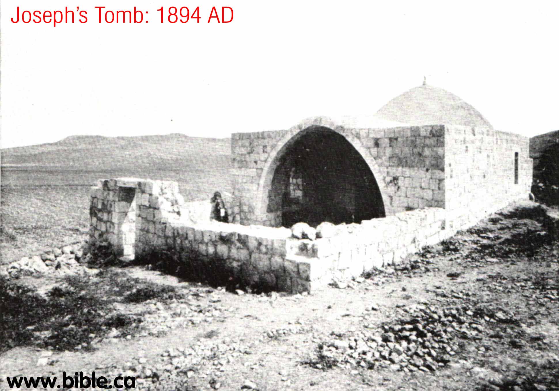
- On 7 October 2000, Joseph's Tomb, the
third most holy place in Judaism, was destroyed by Muslims. It is located
east of modern Nabulus between Shechem (Tel Balata) and Sychar at the foot
of Mt. Ebal. It had come under attack and the Israeli Defense Forces (IDF)
withdrew after gaining reassurances from the Palestinian Authority (PA)
that they would protect the site in accordance with their obligations
under the Oslo Accords to protect holy sites. Two hours after the
withdrawal Muslims began destroying the site. It was burned and torn down
stone by stone, then bulldozed. It was immediately declared a Muslim holy
site.

D. The ceremony in Shechem, Mt. Ebal and Mt. Gerizim.
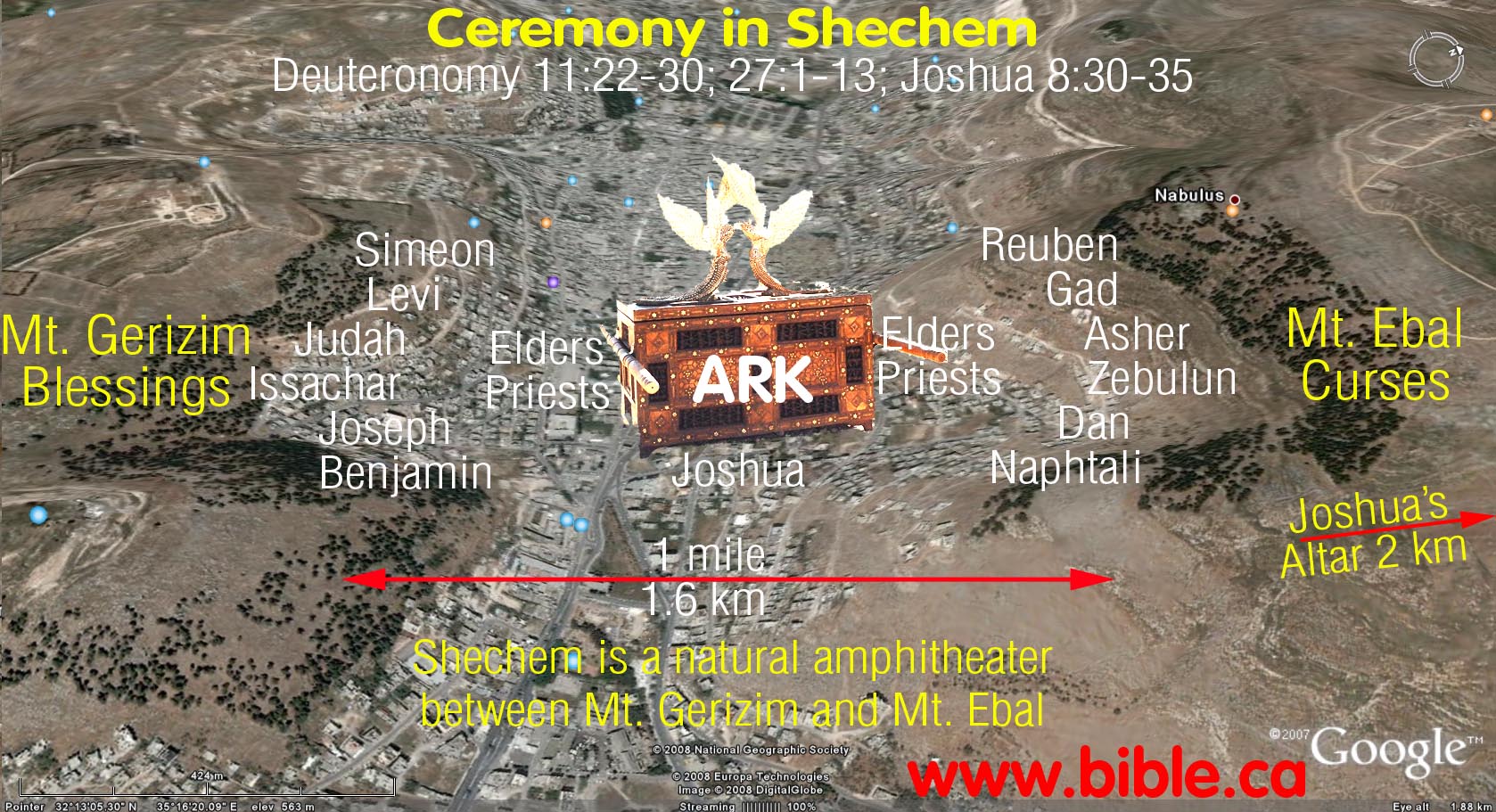
Scientists have tested this natural amphitheater many times and it works very well. This proves the ceremony of Joshua 8 could have really happened here.
Deut 11:22-30; 27:1-13; Joshua 8:30-35
- There was an elaborate and unique ceremony that took place at Shechem. It must have been an absolutely spectacular thing to be part of.
- In 110 AD, Josephus says recounts the ceremony: "from there he went to Shechem, together with all the people, and raised an altar where Moses had beforehand directed; then did he divide the army, and place one half of them on Mount Gerizim, and the other half on Mount Ebal, on which mountain the altar was; he also placed there the tribe of Levi, and the priests. (And when they had sacrificed, and denounced the [blessings and the] curses, and had left them engraved upon the altar, they returned to Shiloh. (Josephus, Antiquities 5.1.19, 68-70)
- It is clear that the ark of the covenant was located in the valley between Mt. Ebal and Mt. Gerizim. Joshua stood beside the ark. The elders, priests and leaders of the people divided up into two groups and stood directly beside each side of the ark. The 2.5 million people then divided up into two groups: 7 of the tribes on the slopes of Mt. Gerizim and the other 6 tribes on the slopes of Mt. Ebal. Remember that Levi was not one of the twelve tribes and Joseph was represented by two tribes.
- There were 22,000 Levites: Numbers 3:39 who spoke the curses and blessings were read by all the Levite priests to the people. This would make it easy to hear on each mountain as each of the corresponding blessings and curses were read. 22,000 men can create quite a volume.
- The Census of Numbers 26, at just before crossing the Jordan: 601,730 of men over the age of 20. This number did not include Levi who was not enumerated. Curses on Mt. Ebal: Reuben + Gad + Asher + Zebulun + Dan + Naphtali = 307,930. Blessings on Mt. Gerizim: Simeon + Levi + Judah + Issachar + Joseph (Ephraim + Manasseh) + Benjamin = 293,800. But Levi was not enumerated in the census. The difference in numbers between the two sides was 14,130 and when we add in the women and children from Levi, that brings it up about equal. We know from Numbers 3:39 that there were 22,000 male Levites aged 20 and older. But many of these would likely be included in the actual pronouncements of the blessings and curses. So in the end, the numbers on each of the two mountains was pretty close to an equal split of about 1.25 million on each side for a total of 2.5 Million. Today, this many people easily fit into areas much smaller than the space Israel had on the two mountain tope, sides and valleys in front of the ark.
- When the priests read the curses to the people sitting on Mt. Ebal, the people sitting on Mt. Ebal would reply "Amen" after each curse was pronounced. The same was repeated for the blessings to the people sitting on Mt. Gerizim. "The Levites shall then answer and say to all the men of Israel with a loud voice, 'Cursed is the man who makes an idol or a molten image, an abomination to the Lord, the work of the hands of the craftsman, and sets it up in secret.' And all the people shall answer and say, 'Amen.'" Deuteronomy 27:14-15
- Joshua was to do a burnt offering sacrifice of an animal at the altar. It is not clear when this offering was made in respect to the timing of the ceremony. It could be that the offering was made before, during or after the blessings and curses were pronounce.
- The altar appears to be a one time use structure never intending to replace or compete with the altar of burnt offerings of the Tabernacle.
- The town of Shechem is a natural
amphitheater which has been tested several times to see if the ceremony of
Joshua 8 is possible. Each test proved the ceremony was easily possible,
especially if 22,000 priests are shouting and one million people are
replying!

- The location of the altar was about 3 km north of where the ark was located. There is no reason why the altar had to be located within view of the people.
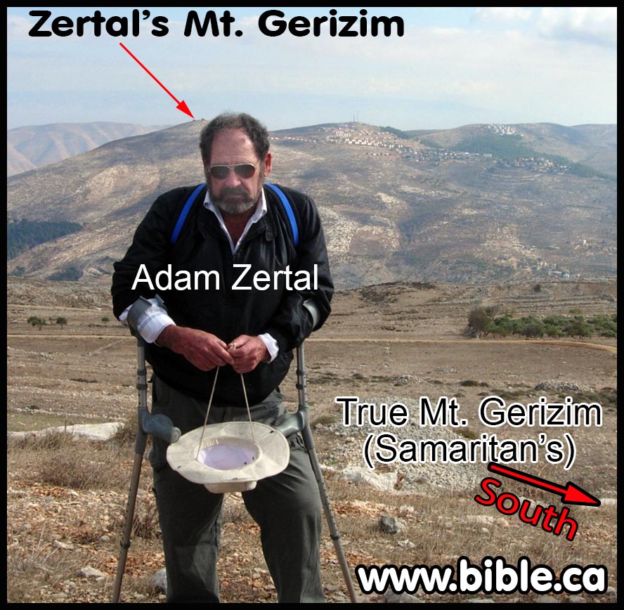
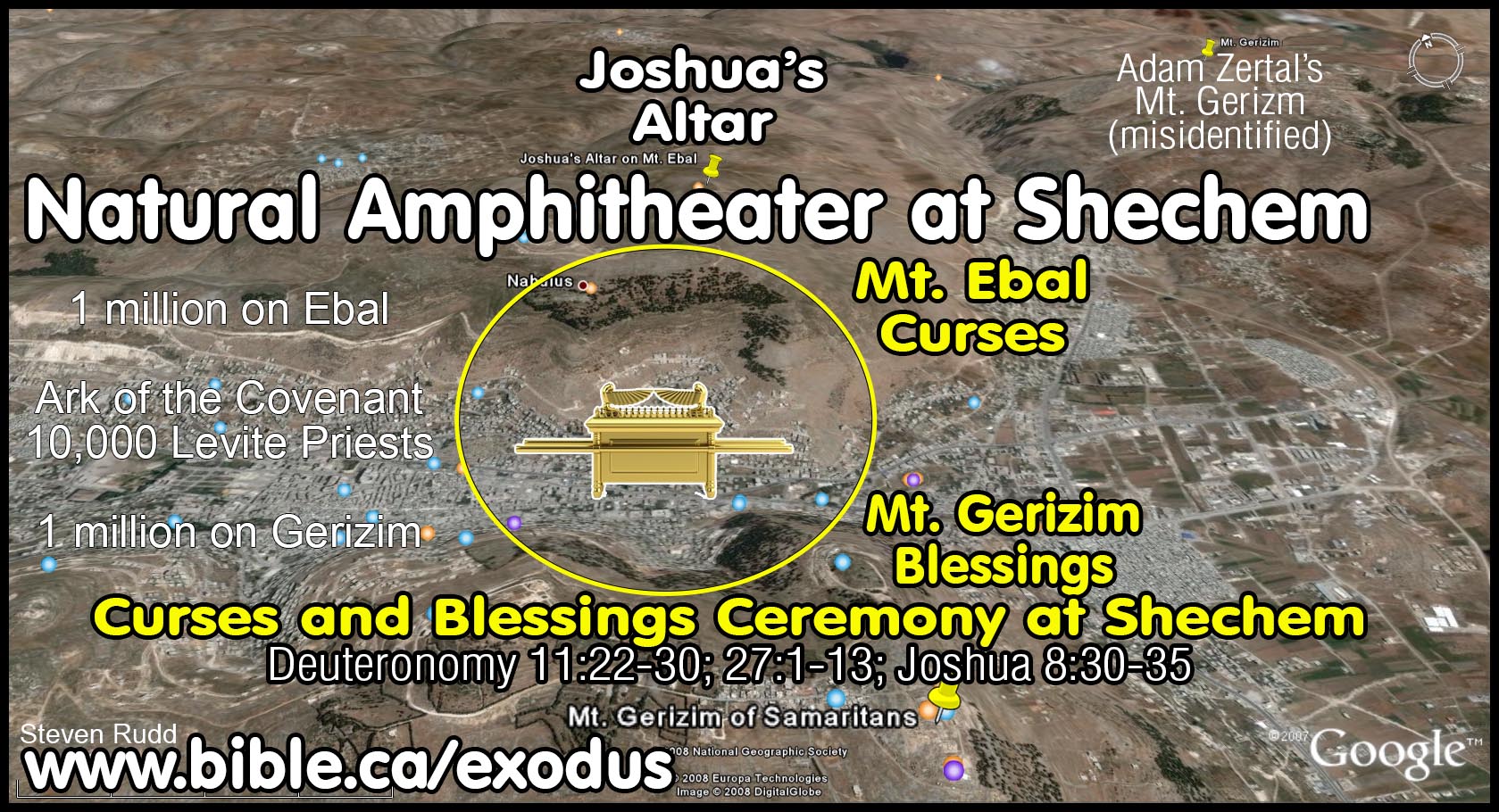
- The location of Joshua's altar that Adam Zertal discovered in 1980 doesn't disqualify the traditional Mt. Gerizim from being the correct location for that mountain. Zertal mistakenly thinks the location of the altar proves the Samaritans chose the wrong mountain in 500 BC as Mt. Gerizim. Zertal has chosen a new different mountain for Mt. Gerizim because of this. (see below) We disagree with Zertal and accept the Samaritan location for Mt. Gerizim.
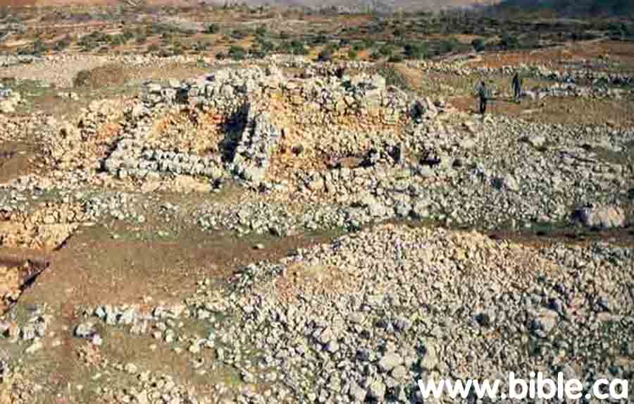
E. The location of Joshua's Altar on Ebal:
- Here is what the mound of rocks looked
like before excavation. "The excavators were surprised to find that the site had been deliberately buried under a layer of
stones before it was abandoned, presumably to prevent its
desecration. Perhaps abandoning Mt. `Ebal was related to establishing a
sacred site at Shiloh and the focus of the Israelite population shifting
from the territory of Manasseh in the north to that of Ephraim in the
central part of the country." (Adam Zertal)

- Ancient Shechem (Modern Nabulus) is
located between Mt. Ebal and Mt. Gerizim.

- Here is an aerial view of Joshua's Altar
site:
- A close up view of the site with an
aerial photo inset

F. The rectangular Hebrew altar of 1250 BC:
- If you visit the site today, this is what
the altar looks like. This altar was built in 1250 BC and is a Hebrew
altar.
- Here is the site early on in the
excavation:
"A ramp of unhewn stones, 4 feet wide by 23 feet long, rises to the top of the platform from the southwest. The gentle incline, easily climbed and the presence of the ramp itself accord with the explicit scriptural injunction: "Neither shalt thou go up by steps unto Mine altar, that thy nakedness be not uncovered thereon" (Exodus 20:26)." (Adam Zertal) - The four corners of the altar point to the four corners of the compass instead of the usual Hebrew custom of the sides facing to the compass. "Yet another detail of our altar suggests its Mesopotarnian roots. The four corners of our altar point north, south, east and west. In Mesopotamia, all sacred structures were oriented so that each corner was directed to a point on the compass. By contrast, the Second Temple was oriented so that its sides, not its corners, faced the four directions of the compass. The Temple altar had this same orientation." (Adam Zertal) "It is interesting that the corners of the platform point due north, south, east and west. The practice of constructing sacred buildings so that their corners pointed in the directions of the compass was characteristic of Mesopotamia throughout its history. Temples, as well as altars, were always oriented in this way. The practice stems from the nature of the religion which developed in Babylonia and Assyria, based on four principal natural forces: earth, fire, air and water." (Adam Zertal)
- This must be an altar, it cannot be a house or a watchtower: "Our initial thought was that this was a farmhouse or perhaps a watchtower. But it was different in almost every respect from the farmhouse's watchtowers we know from examples all over the country. When we reached the bottom of the structure, we immediately noticed that there was neither a floor nor an entrance. The walls were laid directly upon bedrock. Obviously, we were not dealing with a building that had been regularly lived in. To explain the structure as a watchtower is even less satisfactory, because there is no reason for a watchtower to be here. Mt. Ebal has always been an obstacle to transportation. All transportation routes have avoided it. There is, thus, no road for a watchtower to observe. And there were no Iron Age settlements nearby." (Adam Zertal)
- This is a drawing of the site discovered
in 1980 by Zertal:
- Kempinski, who is a Bible trasher, has
suggested that the 1250 BC altar at Mt. Ebal is exactly like the
installations at Giloh. Superficially there appear to be similarities, but
Kempinski has been soundly refuted in this regard and it is generally agreed
that Mt. Ebal is not a watchtower. "According to Aharon Kempinski,
this plan of Giloh, an Iron Age site near Jerusalem, shows a square
structure, top, left, similar in shape and details to the Mt. Ebal
structure that Adam Zertal identifies as an altar. The plan has been drawn
by Amihai Mazar, the excavator of Giloh. Mazar identifies this building as
a watchtower, built in Iron Age II (1000-586 B.C.) and reused in the
Middle Ages. Mazar's plan shows a wall built around the Iron Age
settlement that, according to Kempinski, closely resembles Zertal's
temenos wall at Mt. Ebal." (Joshua's Altar—An Iron Age I Watchtower,
Aharon Kempinski, 1986, BAR)

- "In Level I (the later level), around 1200 B.C., the site underwent a complete change. A large burnt-offering altar was erected upon the earlier cultic area, burying it under the debris of the earlier cultic activities and leaving the central feature of the earlier stage or platform in the exact center of the new one. The altar complex included courtyards, installations, a surround on the altar and ramps leading to it—all typical of the Israelite-altar model found in the Book of Ezekiel and the Second Temple altar described in Mishnaic sources. At the same time that the altar was built (in Level I) an inner temenos wall was added, surrounding the site and enlarging the earlier cultic area four times. There were no structures besides the altar within the inner temenos wall. A wide gateway in the inner temenos wall was constructed. Also, a second and much larger enclosure wall (the outer temenos wall) was constructed, thus creating one enclosure inside the other. No doubt, this ritual center was intended mainly for the gathering of a relatively large number of people. The evidence for this lies in the special location of the enclosure, in a way that the viewer could see the ceremonies on the altar from outside the enclosure wall. How long did this cultic center exist? Archaeologically speaking, not very long. The evidence of the pottery cannot be stretched beyond the middle of the 12th century B.C. (The most recent analysis of Level I pottery has necessitated raising the date of the end of this level about 50 years.) I would estimate this center's existence to be not more than 50 years. The site was never destroyed, however. Rather, it was deserted while in a complete and finished state. Why? We do not yet know. Its desertion, just as its erection, seems somehow to have been the result of a deliberate decision, and not of a natural development. There was no reason for such an abandonment based on environmental conditions. But such desertions are well known at Iron Age I sites; Mt. Ebal is no exception. The desertion of the site resulted in the fact that we now have a complete and untouched Israelite cultic center from the time when monotheism began—to be studied by archaeologists, Biblical scholars and other concerned scientists, both Jewish and Christian, from all over the world." (How Can Kempinski Be So Wrong!, Adam Zertal, BAR, 1986 AD)
- Here are two drawings of the small ramps
on the left and right hand side of the altar. These were understood when
reading the Mishna. "Adjacent to the northern side of the ramp is
another small, narrow wall, somewhat lower than the one beside it. It
turns out that this smaller ramp, which greatly intrigued us since we
could find no constructional logic for it, was intended as a means of
ascent for the priests to reach another part of the altar, the surround or
ledge. This is none other than the above-mentioned terrace adjacent to the
altar, which was reached by climbing the smaller ramp adjacent to the
larger one. All this became clear to us only after reading the extremely
precise Mishnaic descriptions of the Second Temple in Jerusalem: "The
altar was thirty-two [cubits] by thirty-two [cubits]. It rose up one cubit
and receded one cubit; this was the base. [Thus] we find left [a square
space of] thirty by thirty. [The next part built up on the base] rose up five
[cubits] and receded one cubit; this was the surround. Thus we are left
with twenty-eight by twenty-eight... And there was a ramp at the south of
the altar, thirty-two cubits by sixteen cubits in width..." (Middot
3:1-3). About the smaller ramp the Mishnah writes: "How was this
performed? The priest went up the ramp and passed around the ledge, and
came to the southeast corner..." (Zevahim 5:3).The mishnaic
description of the altar depicts a sort of graduated tower in which each
successive level is somewhat smaller than the one below it. In the Second
Temple period there were three levels, whereas the altar on Mt. 'Ebal has
only two. These levels are formed by the surrounding ledge (see
photographs and reconstruction). Interestingly enough, the future altar,
described by Ezekiel, which most scholars believe reflects the altar in
the First Temple, was also built in successive levels: "And these are
the measures of the altar by cubits - the cubit is a cubit and a
handbreadth: the bottom shall be a cubit, and the breadth a cubit, and the
border thereof by the edge thereof roundabout a span; and this shall be
the base of the altar. And from the bottom upon the ground to the lower
settle shall be two cubits, and the breadth one cubit; and from the lesser
settle to the greater settle shall be four cubits, and the breadth a
cubit: And the hearth shall be four cubits; and from the hearth and upward
there shall be four horns"(Ezekiel 43:13-15)." (Adam Zertal)
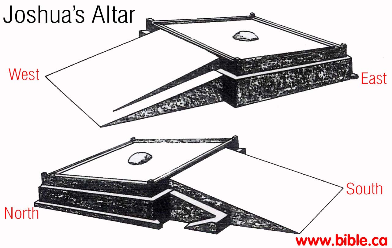
G. Joshua's actual Altar: The older round altar of 1406 BC:
NOTE: Here is a brief account by Adam Zertal in 2004, of the round structure underneath the rectangular altar. We must make it clear that Adam Zertal does not call the round structure an altar, WE DO. He dies not date it to 1406 BC, WE DO. He dates the round structure 50 years older (1300 BC) than the rectangular altar we see today on top (1250 BC).
"As we dug deeper into the strata of fill, it became clear that the cultic center, even the large altar itself, had been preceded by another cultic site. On the natural bed-rock, beneath the geometric center of the altar, we discovered a round structure, about 6.5 feet in diameter, built of unhewn stone. It was found full of yellowish material, above which was a thin layer of ashes and burned animal bones. At first we thought this was part of the altar. Shortly, however, levels of habitation preceding the large altar emerged in other parts of the site as well. Around the early, circular structure were signs of further cultic activity: an earthen floor paved with pottery, a large collar-rimmed jar, and other vessels. ... A rough wall, constructed of large boulders, was built to enclose a sacred area. In the center was a round structure, possibly used for sacrifice, and around it other activities took place." (Adam Zertal, 2004)
"After several decades of the site's existence, a revolutionary change occurred there. From a small place, sacred to one family or perhaps to the region, it suddenly became a central cultic site of supra-tribal or perhaps even national importance to the entire alliance of the tribes. A new temenos was built, as well as a broad, paved gateway. A large and complex burnt offering altar, comprised of the platform itself, a surround, a small and a large ramp, and paved courts, was built on top of the earlier round structure. When this larger complex was constructed, so it seems to us today, the remains of bones and ashes from the earlier rites were gathered together and used to fill the new altar. Burying the earlier structure in the center of the newer one apparently symbolized the continuity of the tradition of sanctity attached to the site." (Adam Zertal, 2004)
"When we excavated under the fill, we found some curious stone-built installations. One installation consisted of a circle made of medium-sized field stones laid on bedrock and located at the exact geometric center of the structure. The outside diameter of the circle of stones was 6.5 feet. The circle of stones was filled with a thin, yellowish material that we have not yet identified. ...
On top of this yellowish layer was a thin layer of ash and animal bones. This installation as well as the others inside the structure were clearly used in some fire-related activity before the structure was built. It is quite obvious, now, that the installations at the bottom of the structure represent an earlier phase, and the large structure itself represents a later phase-both from the same Iron I period." (Adam Zertal)
"Strange installations in the northern court of the altar complex. Five box-like installations built of stone were discovered in a row near the ramp that ascends the altar. Some contained large quantities of ash and burned bones from animal sacrifices, others complete pottery vessels unearthed in situ. This discovery, like that of the altar, reveals the hitherto undisclosed world of religious ritual of the early Israelites." (Zertal 2004)
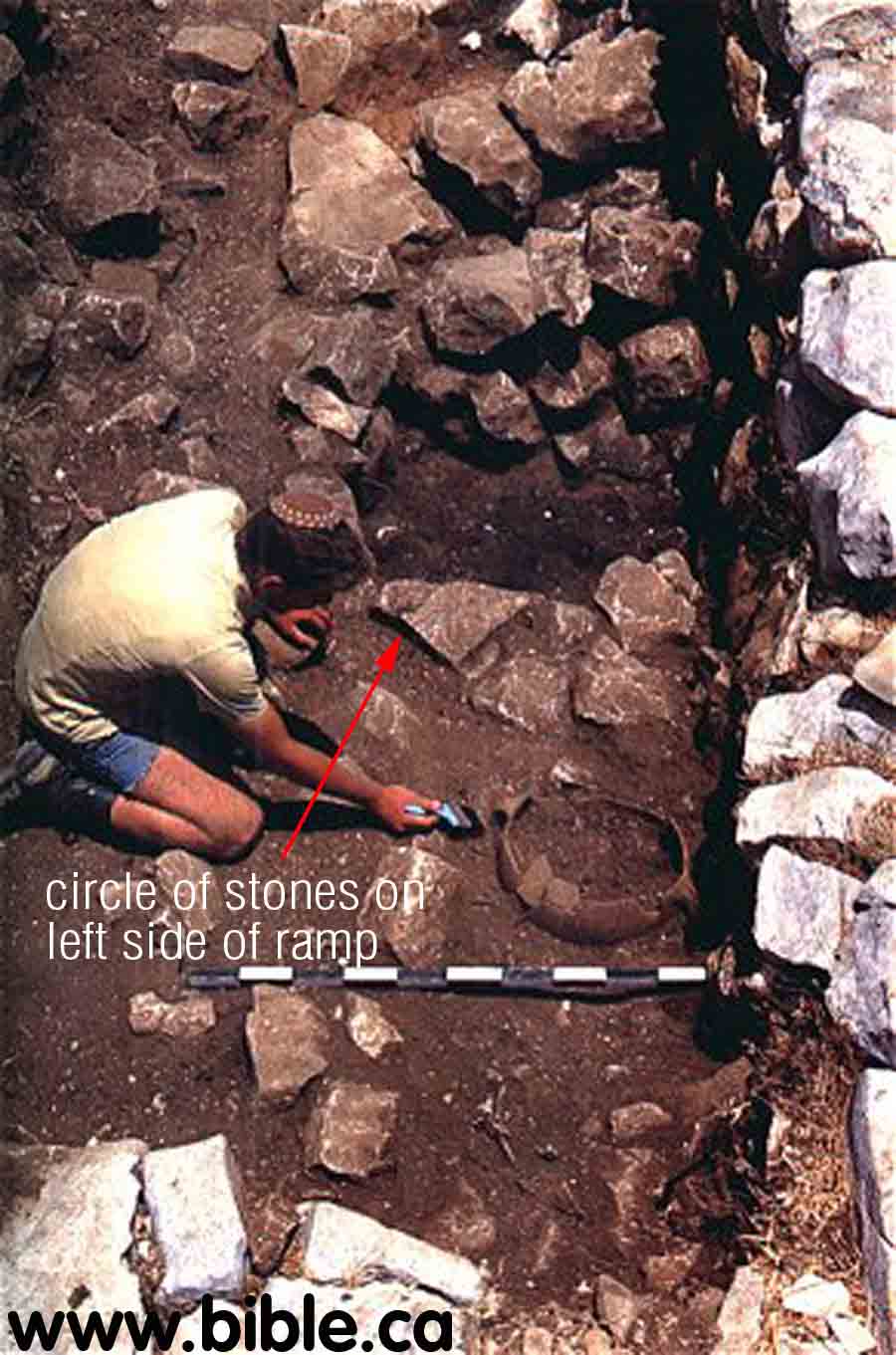
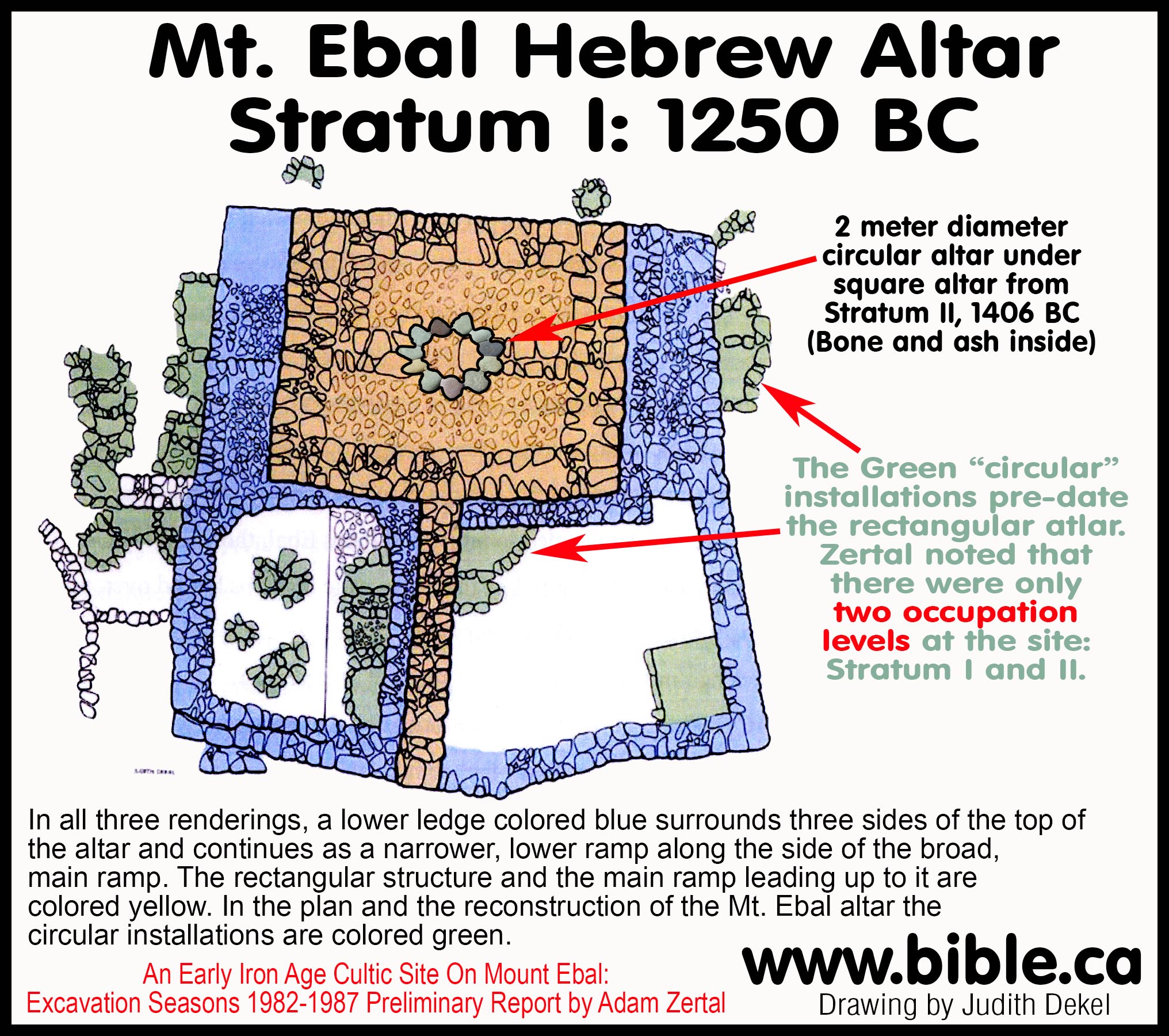
"In all three renderings, a lower ledge colored blue surrounds three sides of the top of the altar and continues as a narrower, lower ramp along the side of the broad, main ramp. The rectangular structure and the main ramp leading up to it are colored yellow. In the plan and the reconstruction of the Mt. Ebal altar the circular installations are colored green." (Zertal)
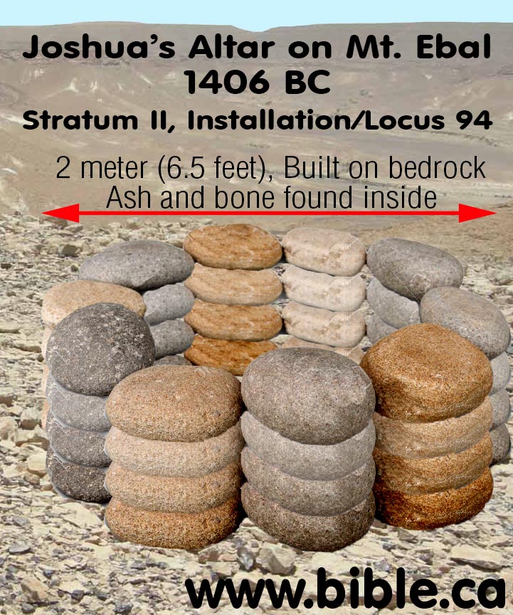
Here is a reconstruction of what the altar would have looked like on Mt. Gerizim. It is 6.5 feet in diameter and built on bedrock.
We disagree with Adam Zertal when he dates both the round altar and the rectangular altar that was built directly on top of it to within 50 years. "I would estimate this center's existence to be not more than 50 years." (How Can Kempinski Be So Wrong!, Adam Zertal, BAR, 1986 AD) While this is entirely possible, we have a better solution.
Here is an actual round altar that dates back to the exodus found at Gilgal. It serves as a model for what the round altar of Joshua looks like at Mt. Ebal.
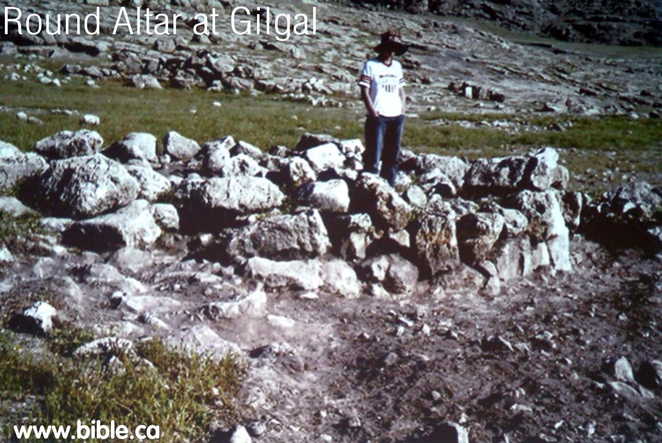
- We believe that the round altar is the one Joshua built in 1406 BC and the rectangular altar was built directly over top of the round one 150 years later in 1250 BC. It could be that the site has been used by Abraham (2000 BC) and Jacob (1930 BC) to build altars before Joshua came in 1406 BC. Then during the time of Deborah the Judge, another altar was built on top.
- Four levels of fill in the rectangular altar area: We believe Adam Zertal is wrong to date the circular altar to the same time as the rectangular one above it. It seems obvious that when they began to build the rectangular altar in 1250 BC, that they scraped everything off the immediate surface and used it as fill directly on top of the circular altar. This explains why most of what was found in connection with the circular altar is dated to 1250 BC. Fill represents the time in which the new structure was made, not the thing being buried. "The empty space itself was filled by the builders with four deliberately laid strata of fill. The lowest stratum contained a considerable quantity of ashes, above it was a stratum of dirt and stones, then another thick layer, approximately three feet deep, containing a large quantity of black ashes. In these ashes were hundreds of animal bones, some of which had been burned in a hearth." (Zertal)
- An Egyptian cartouche was discovered by Zertal at the site of Tuthmoses III dated to 1406 BC. Since this has been found here, we believe it is clear that this round altar underneath the present structure, is Joshua's Altar.
- This brings us to a critical point of this entire discussion about Joshua's Altar. We believe that the reason Adam Zertal did not date the round altar more than 50 years older than the rectangular altar, is because he mistakenly believes the exodus took place in 1250 BC. In his mind, if the round altar (as we call it, not Zertal) was much older than the rectangular altar, then it would predate the time Israel crossed the Jordan. It would mean that the round altar was a pagan altar built by the Canaanites. Such would be enough to prove the rectangular altar we see today could not have been built by Joshua, because no Hebrew worshipper of Yahweh would ever build an altar overtop of a pagan altar. Of course one way around this is to speculate that Abraham or Isaac built the altar and God led him to the exact same spot. While this is possible, it is unlikely and where is the archeological evidence?
- We would humbly invite Adam Zertal to
read this paper on the Exodus
being at 1446 BC, not 1250 BC. The altar changed him from a Bible skeptic
to a Bible believer. We suggest that he go all the way and accept the
Bible's date of 1406 BC when Joshua built his altar. Zertal probably knows
enough about the site that he could actually make a good case for this
round ring of rocks being dated to 1406 BC, but simply could not because
he mistakenly believed the exodus happened in 1250 BC. If he accepts the
Bible's date of the exodus of 1446, then he can date the 6.5 foot diameter
circle of stones up to 150 years earlier and still be within the time
Israel crossed the Jordan. He can contact the author by email here if he wishes
further discussion.
- Hebrew altars are generally square. Pagan Altars are square. This circular altar is the second one we know of. Another round altar built of stones is found at Gilgal.
- Israel Finkelstein, a known Bible trasher archeologist, may have shot himself in the foot again. He views the exodus and the kingdoms of David and Solomon as myths. In an effort to refute the truth that Israel actually settled Canaan as the Bible said, he argues that the Mt. Ebal site is older than what he believes is the date of the exodus. Problem is, he believes the exodus was 1250 BC, when in fact it was 1446 BC. "Adam Zertal, the excavator of a twelfth century hilltop site on Mt. Ebal, describes the site as cultic. A number of installations, including what may have been the remains of a stone altar, were encircled by a stone wall. Among the artifacts recovered were animal bones. These, as well as biblical references to Joshua's altar on Mt. Ebal (Deut 11:29; 27: 4-8; Josh 8:30-32) have led some to conclude that this was a open-air cultic site, perhaps an altar sacred to the early Israelites (Zertal 1986/1987; A. Mazar 1990b: 348-50). Kempinski suggested that the search for Joshua's altar should instead take place on Mt. Gerizim, in the vicinity of the Samaritan Temple (1993: 237*). Finkelstein agrees that the Mt. Ebal site was cultic but dates it to an earlier period, since he identifies ninety percent of the potsherds as Middle Bronze Age (1995 The Great Transformation: The "Conquest" of the Highlands Frontiers and the Rise of the Territorial States. Pp. 349-65 in The Archaeology of Society in the Holy Land, ed. T. E. Levy. London: Leicester University.p 359). Others disagree with the cultic identification, suggesting that its central stone installation was the foundation of a farmhouse or fortress and not an altar (Kempinski 1986; Dever 1992b: 32-34; Fritz 1993: 185). According to Coogan, the site was cultic in function, but may not have been Israelite, let alone the location of Joshua's altar (1990: 25-26). For a discussion of the difficulties in explaining the artifactual and architectural evidence on Mt. Ebal, see Gilmour 1995: 108-20. See Zertal 1993: 377 for a brief summary of the controversy." (Archaeology and the Religions of Canaan and Israel, Beth Alpert Nakhai, 2001 AD)
- At this point, we really cannot be sure until further seasons are spent excavating at the site to determine exactly what the origin of this circular altar is. We would like to see the entire rectangular altar carefully removed so it can be reconstructed later. This way excavations can take place below the rectangular altar of 1250 BC, down to the 1406 BC bedrock level of the circular altar. The significance of the discovery of a scarab of Tuthmoses III, dated to 1406 BC, found at the site cannot be underestimated.
H. Egyptian scarabs, pottery and bones found:
- Most exciting and promising is the scarab found from Tuthmoses III, who is the pharaoh of the exodus in 1446 BC.
- Zertal also found pottery that dated to 1250 BC.
- Zertal also found 8 pieces of plaster with no writing on it. Scientific testing has been done, but results are pending.
- In the altar was found a collection of
942 bones from 50-100 individual animals. These were scientifically
Analyzed by Hebrew University of Jerusalem and determined to be all kosher
one year old animals. The species included: Goats, Sheep, Cattle and one
gazelle: "When compared to other Iron Age habitation sites, some
interesting differences are apparent between Ebal and the others. The
first is the difference in emphasis in species present. Equids [the genus
that includes horses, donkeys, etc.], pigs, carnivores and gazelle (both
wild and domesticated) are absent at Ebal, but present at the Iron Age
sites of Lachish, Tel Qasile, Tel Miqneh, Tel Dan, Hazorea, Tel Michal,
Shiloh, Beer-Sheva, Tel Masos and Izbet Sartah. The species represented
and their frequency suggest that only edible animals are present at Ebal,
while at other sites animals possibly used for various purposes (such as
equids) are present. The specific absence of gazelle and pig remains is of
interest considering their presence in the immediate vicinity of the site,
both in antiquity and today. This is further emphasized by the high
frequency of fallow deer, which shares a similar environment to wild pig,
though the latter does not appear to have been hunted at Ebal. ... An
aspect which further highlights the difference between Ebal and habitation
sites is the number and distribution of burnt or scorched bones from Ebal
(28 bones forming 9% of the diagnostic bone sample) compared with 8 bones
(0.8%) from the Iron Age levels at the City of David (from a bone sample
of approximately 1,000 bones). Wapnish has reported that 15% of the equid
material (total of 65 bones) from Tel Jemmeh had cut marks and burning.
Though the exact period distribution of this 15% is not specified, this
and the City of David data indicate that the burnt material from Ebal is
slightly, but not significantly higher in proportion to the total bone
sample. However, the most salient feature of the Ebal burnt material is
the concentration of the bone in the altar area (17 of the 28 bones or 61%
of the total burnt bone samples from the site). This further suggests some
difference in activities between the areas at the site. ... Ebal differs
from other Iron Age sites in the absence of certain species such as
equids, pigs, gazelle and carnivores and in the presence of a high
frequency of fallow deer. In addition, the comparative data on burnt bones
suggests a frequency at Ebal, slightly higher than that expected from a
bone sample of this size. ... All of these features indicate a different
pattern of animal utilization at Ebal to that found at Iron Age habitation
sites. ... It is suggested that the Ebal faunal assemblage represents a
narrow range of activities either in function or time. The absence of
animals prohibited for consumption but frequent at other Iron Age sites,
suggests conformity with Biblical tenets." (Faunal Remains from the
Early Israelite Site of Mt. Ebal," Liora Kolska-Horwitz, Department
of Zoology, Hebrew University of Jerusalem, Conclusions)
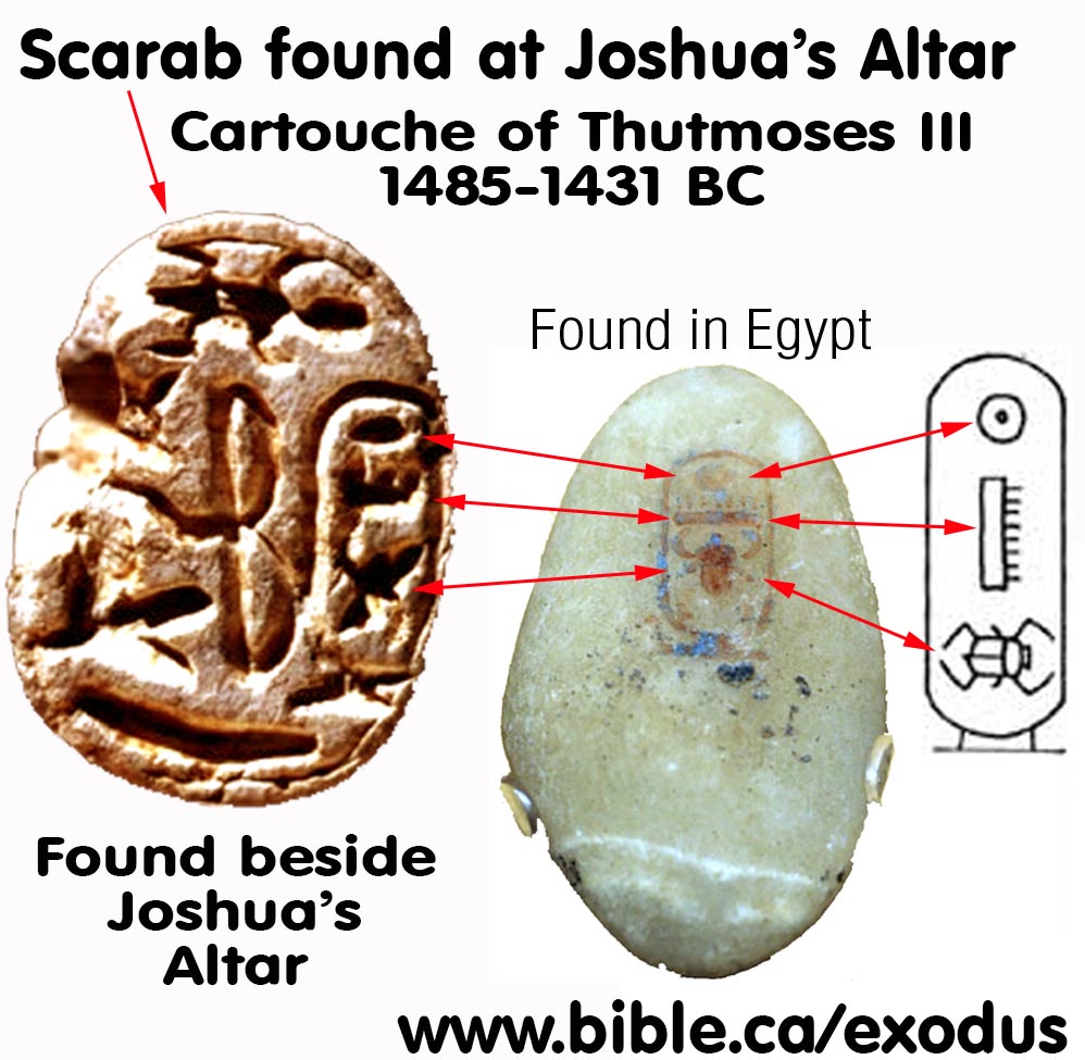
- Scarab found from the pharaoh of the Exodus:
- This scarab was found inside an offering structure. It displays a kneeling Egyptian archer and the cartouche of Tuthmoses III, the great Egyptian conqueror.
b. When Ramesses II reigned (about 1290-1224 B.C.) this carnelian scarab was issued to honor Tuthmoses III (1479-1425 B.C.). Found recently just north of the Mt. Ebal altar, the rare artifact pinpoints the date of the altar to this period in the 13th century B.C. What looks like a capital letter "B" in the center of the scarab is a double bow held by a kneeling archer, far left. The cartouche of the great conqueror Tuthmoses III appears at the far right. At the top is a crawling salamander, an Egyptian symbol of abundance.
c. "A scarab, or Egyptian-style signet ring, found in the altar's fill. The use of scarabs - seals and charms prevalent in ancient Egypt -spread over the entire ancient East. This seal, carved in the shape of a beetle an insect sacred to the ancient Egyptians -contains Egyptian religious symbols and scenes on its lower portion. Relatively crude in its workmanship, the scarab's ornamentation is geometric: a four-petal rosette with shoots between the petals, and a Uraeus (Egyptian cobra) emanating from each shoot. Discovering this scarab in the altar's fill enabled archaeologists to date the entire stratum, since the scarab can be ascribed with certainty to the great pharaoh Ramses II and to the latter part of his reign, 1245- 1220 b.c.e. Similar scarabs, dating to the same era, have been found in Egypt and Cyprus." (Zertal)
d. Providentially Adam Zertal is excavating at: Gates of the Aruna Pass the summer of 2008. This may provide more insights into Tuthmoses III, as the Pharaoh of the Exodus: "The Gates of the Aruna Pass: The site of Tell Assawir ("Mound of the Bracelets") is situated in perhaps one of the most strategically important areas in all of Israel. Located in the northern Sharon Plain at the approach to the northern foothills, Assawir controlled access to the narrow and rugged Aruna pass, the most direct route between the age-old coastal road and the inland Jezreel corridor. Assawir has thus seen its fair share of history, most notably in 1482 B.C. when Tuthmoses III of Egypt used the Aruna pass to gain a decisive victory over a large coalition of Canaanite chiefs that had fortified themselves at Megiddo. The victory would ultimately help the Egyptian New Kingdom pharaohs establish hegemony over southern Canaan for the next three hundred years. Although scholars still debate the site's ancient name and the specific role it played in the military strike of Tuthmoses III, there is little question that it was a major fortified site of the Middle Bronze and Late Bronze Ages. Recent excavations have shown that the large mounded site of Assawir (measuring some 15 acres) was established in the early second millennium B.C. and was protected by a steep-sided earthen rampart and glacis, a typical feature of Bronze Age Canaanite towns. The site continued to be occupied in the Iron Age I after the Egyptian empire had collapsed and, by the Iron II, Assawir was a major town of the northern kingdom of Israel. This summer (2008), you can help archaeologists from the University of Haifa dig deeper into this fascinating but still poorly understood site. The goals for this season will be to locate and excavate the Middle Bronze Age palace, further explore the city's Bronze Age fortification system and penetrate the mound's Iron Age I strata." (Adam Zertal, Director of dig)
a. 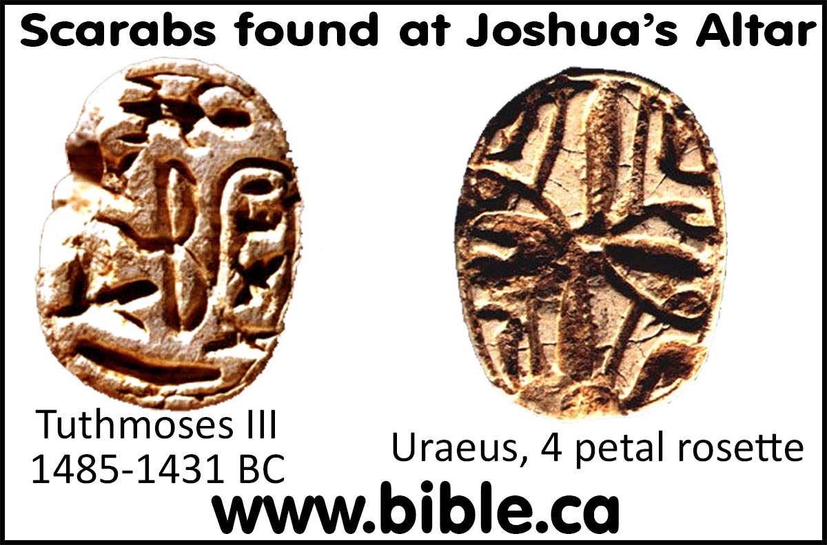
b. 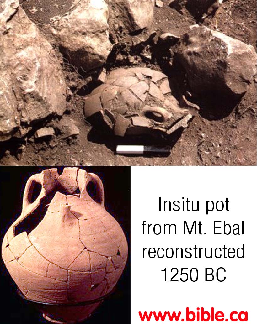
7. Pottery was found that dates to 1250 BC. Here is a photo of an insitu pot and how it looks today in the Museum.
a. In AD 1985, Adam Zertal excavated an incense altar at Joshua’s altar in stratum II.
b. In the AD 1906, Flinders Petrie excavated a similar sandstone incense and libation altars from the Hathor temple at Serabit el-Khadim which Petrie dated to the Late Bronze Age and identified as of Semitic (i.e. Hebrew) origin. Hebrews worshiped Hathor/Ashtaroth the cow goddess at Serabit el-Khadim and as the golden calf at Mt. Sinai in 1446 BC. In 586 BC the Jews offered libations to Hathor as the “queen of heaven” (Jer 44:19.)
c. In AD 2016, Douglas Petrovich identified a series of Hebrew “Sinai Inscriptions” at Serabit el-Khadim that he dated to the time of the exodus. Although Zertal never tested the origin of the pumice, it may have been from the Thera eruption, which Manfred Bietak (excavator of Goshen at Tel el-Dab’a) dated to the time of Thutmoses III using low Egyptian chronology. To complete the circle of evidence, Zertal used Petrie’s sandstone chalice as a parallel for the Mt. Ebal chalice in his exaction report. “Pumice chalice. This vessel was placed in Pit 250 before the Stratum LB fill was poured and therefore dates to Stratum II. It is 10 cm. high and the diameter of the base - and upper bowl is 8.5 cm. The bowl is 3 cm. deep.” (Adam Zertal excavation report of Joshua’s altar, 1985 AD) During the exodus, Moses camped at Succoth on the Gulf of Suez, at a location which is directly adjacent the turquoise mines of Serabit el-Khadim to pick up the Hebrew slaves who worked there.
d. In AD 2005, Steven Rudd redated Zertal’s stratum II from 1275 BC to 1406 BC because both the scarab of Thutmoses III and the pumice incense altar were excavated from stratum II.
I. Mt. Gerizim is located next to Shechem and beside the oaks of Moreh:
- Here is a detailed study of the Samaritans and why they chose Mt. Gerizim as "their Jerusalem".
- The oaks of Moreh were beside Mt. Gerizim and two Bible verses place the oaks of Moreh beside Shechem (modern Nabulus). Genesis 12:6 and Genesis 35:4.
- Judges 9:7 likewise places Mount Gerizim directly beside Shechem: "Jotham went and stood on the top of Mount Gerizim, and lifted his voice and called out. Thus he said to them, "Listen to me, O men of Shechem, that God may listen to you."
- In 325 AD, Eusebius believed that the Samaritan's choice for Mt. Gerizim was wrong and said so in his Onomasticon which he wrote in 325 AD. He likely based this on the Bible verse that said it was opposite Gilgal: "Are they [Mt. Ebal and Gerizim] not across the Jordan, west of the way toward the sunset, in the land of the Canaanites who live in the Arabah, opposite Gilgal, beside the oaks of Moreh?" Deuteronomy 11:30.
- In 325 AD Eusebius chose mountains sometimes called "Tyros" and "Thrax" above Aqaba jabr near Jericho. The Samaritans chose "Jebel es-Slamiyeh" and "Jebel et Tur". These are the traditional locations on all Bible maps today and are the correct locations.
- Here is what Eusebius wrote in his Onomasticon
in 325 AD:
Mt. Ebal: "Gaibal (Gebal). Mountain in the Promised Land where Moses commanded an altar to be built (at the command of Moses an altar was built). They say (there are) two neighboring mountains facing each other located at (near) Jericho, one of which (is said) to be Garizin [Gerizim], the other Gaibal [Ebal]. But the Samaritans erroneously point out two others near Neapolis (argue for two mountains near Neapolis but they err greatly) since the great distance of one from the other there shows that they are not able to hear one another when calling out from one (hear the voices calling out in turn blessing or cursing as Scripture records)." (Eusebius, Onomasticon 325 AD)
Mt. Gerizim: "Garizein (Garizin). Mountain where those calling out the blessing (curse) stood. Read the above mentioned Gaibal (Gebal)." (Eusebius, Onomasticon 325 AD)
Gilgal: "Golgol or Galgal. The Scriptures teach this is near Mt. Garisein and Mt.Gaibal. The place of Galgal is in the Jericho region (near Jericho). [Therefore the Samaritans err who would point out Mt.Gairsin and Mt.Gebal near Neapolis which Scripture testifies are near Galgal.]" (Eusebius, Onomasticon 325 AD)
Footnote from Onomasticon : This and the following entry can be treated together. The Onomasticon begins by recording the simple biblical information here. The generally accepted tradition is to follow the Samaritan tradition as given here. The two mountains are on either side of Neapolis (K. 4:28) and are Jebel es-Slamiyeh and Jebel et Tur. The Madaba Map reflects this tradition by having them near Shechem (K. 150:1) called Garizin and Gōbel. The pilgrims also recognize this identity. "At Neapolis is Mt Gazaren where the Samaritans say Abraham brought the sacrifice. And to ascend up to the summit are 300 steps. At the foot of the mountain is located a place by the name of Shechem" (Itin. Bourd. PPT I, 18). Zeno and Justinian built churches on Garizein according to Procopius Buildings V, vii, 5-17. Excavation of this area is going on. But Eusebius and Jerome prefer to follow an anti-Samaritan location. The Madaba map hesitates between the two opinions and so locates Gebal Garizeini near Ierichō [Jericho] (K. 104:25). The use of the LXX names in Ierichō region and the Aramaic in the Neapolis area may signify some preference. Since Josephus and the later Byzantines had the correct tradition, this rabbinic tradition must have developed in the late first and early second centuries. Procopius 905C is also confused: "This is situated at the Eastern part of Ierichō beyond Galgal" and he continues by denying the Samaritan tradition. Yet in 908A he seems to accept the Samaritan location and tradition. The two mountains near Jericho are probably those above Aqaba jabr sometimes called Tyros and Thrax. The Roman road to Jerusalem passed between them. In Interpretation of Hebrew Names "Gebal, ancient abyss or stone building" (87). (Eusebius, Onomasticon 325 AD) - In 542 AD, the Madaba map places the
two mountains twice, in two different locations: On the Madaba map, the
mountains of Ebal and Gerizim are in two different locations. One is at
Shechem (Modern Nabulus) and one near Jericho and Gilgal. This is because
the Orthodox Jews had created a new location near Jericho in their
longstanding dispute with the Samaritans. Eusebius, Jerome and the
creators of the Madaba map were fully aware of the two traditions and
chose to represent both on the map.
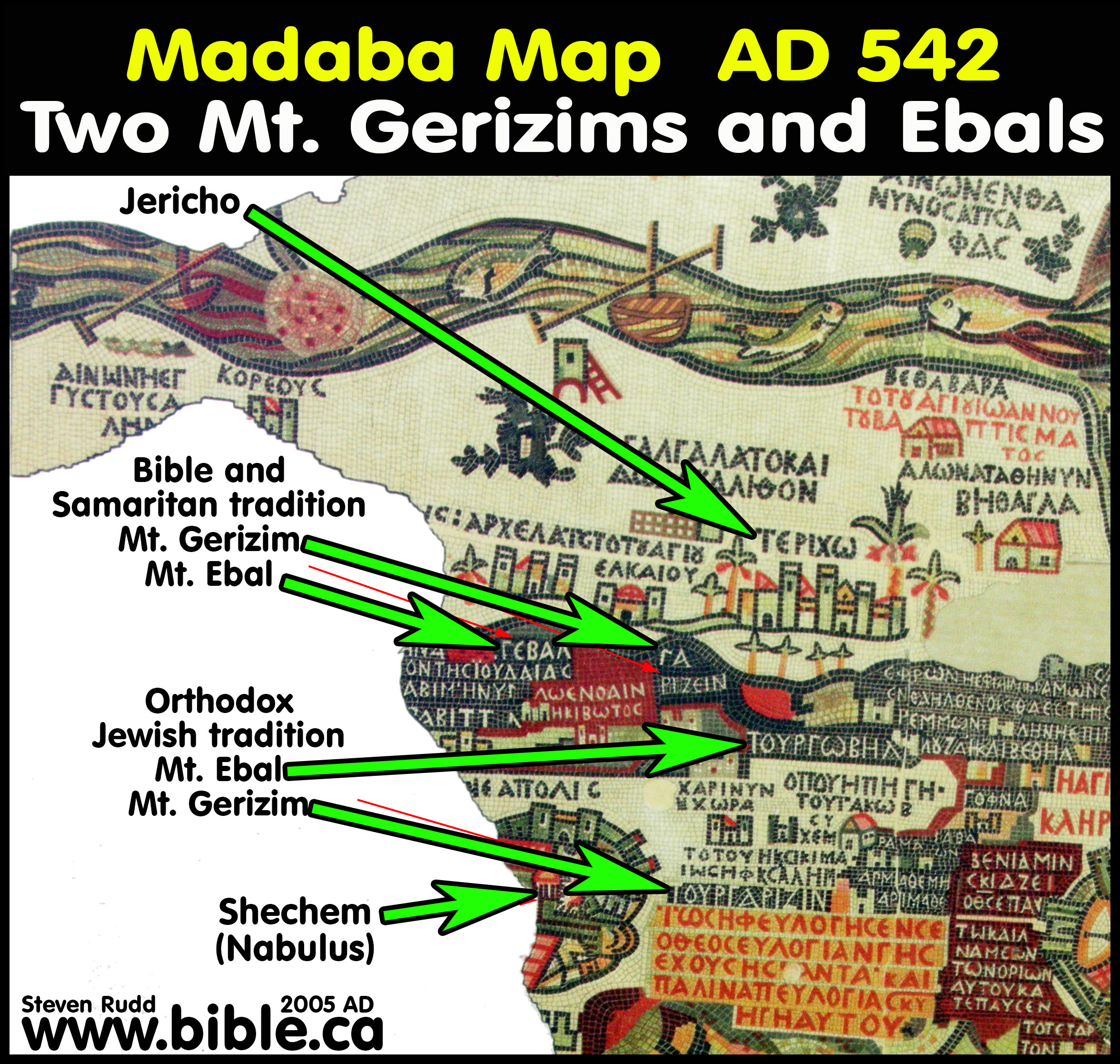
- Herbert Donner comments on this: "The mountains Gerizim and Ebal are represented twice on the Madaba Map: near Jericho and near Neapolis. What has happened here? The problem can be solved on the basis of Eus. On. 64:9-14 where, strangely enough, both mountains are indeed located near Jericho. Eusebius, however, does not fail to add: "The Samaritans show other ones near Neapolis, but they are wrong, for the mountains shown by them are too far from each other, so that it is impossible to hear one´s voice when calling to each other." Although this seems to be entirely intelligible and is confirmed by Deut. 27, the Samaritans were by no means wrong. Eusebius was wrong, and everybody knew it, perhaps he himself included. The Samaritans laid claim to the mountains, considering them to be their own holy mountains. Hostility to the Samaritans forced the orthodox Jews in Jerusalem to locate both mountains at another spot, for the Samaritans were not allowed to be right. Eusebius followed the orthodox Jewish tradition. The mosaicist, however, being well informed, preferred a Solomonic solution: he listed the mountains twice, indicating by larger letters that he regarded the location near Nabulus as being correct." (Herbert Donner, The Mosaic Map of Madaba, Kampen 1992, 24.48)
- In the 1980's, Adam Zertal has chosen an
entirely new location for Mt. Gerizim after discovering Joshua's Altar. Here
is a view looking due east from the left hand side of the 1250 BC altar
structure we see today. Remember Joshua's altar of 1406 BC is a 6.5 circle
of round rocks and is located on bedrock directly below the 1250 BC altar.
One of the problems for Zertal, is that the altar
doesn't directly point to his choice for Mt. Gerizim. Rather the
altar is facing the open plains to the left of Zertal's Mt. Gerizim.
Surely the altar would point directly to Mt. Gerizim since it was directly
in view.
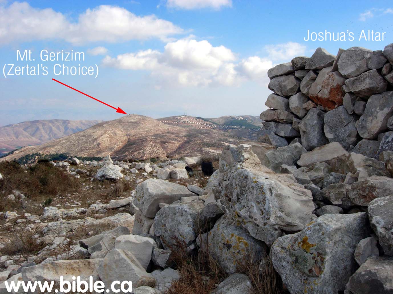 .
. - Here is a close up of Zertal's choice for
Mt. Gerizim taken from the south side of the altar.
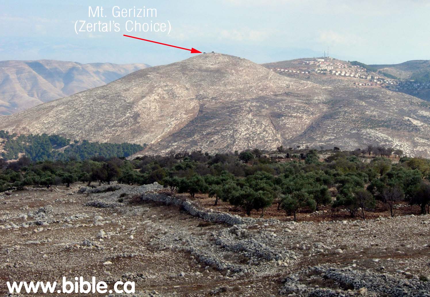
- When all has been examined it is clear that the correct location of Mt. Ebal is where Adam Zertal found Joshua's Altar. The correct location for Mt. Gerizim is where the Samaritans chose it. Zertal's choice for Mt. Gerizim is wrong. Eusebius is also wrong for locating the two mountains beside Jericho and Gilgal.
- The Bible and the Samaritan locations at Shechem (Nabulus) are correct. The orthodox Jewish locations near Gilgal are wrong.
The Bible texts:
- Moses: "For if you are careful to keep all this commandment which I am commanding you to do, to love the Lord your God, to walk in all His ways and hold fast to Him, then the Lord will drive out all these nations from before you, and you will dispossess nations greater and mightier than you. "Every place on which the sole of your foot treads shall be yours; your border will be from the wilderness to Lebanon, and from the river, the river Euphrates, as far as the western sea. "No man will be able to stand before you; the Lord your God will lay the dread of you and the fear of you on all the land on which you set foot, as He has spoken to you. "See, I am setting before you today a blessing and a curse: the blessing, if you listen to the commandments of the Lord your God, which I am commanding you today; and the curse, if you do not listen to the commandments of the Lord your God, but turn aside from the way which I am commanding you today, by following other gods which you have not known. "It shall come about, when the Lord your God brings you into the land where you are entering to possess it, that you shall place the blessing on Mount Gerizim and the curse on Mount Ebal. Are they not across the Jordan, west of the way toward the sunset, in the land of the Canaanites who live in the Arabah, opposite Gilgal, beside the oaks of Moreh?" Deuteronomy 11:22-30
- Moses: "Then Moses and the elders of Israel charged the people, saying, "Keep all the commandments which I command you today. "So it shall be on the day when you cross the Jordan to the land which the Lord your God gives you, that you shall set up for yourself large stones and coat them with lime and write on them all the words of this law, when you cross over, so that you may enter the land which the Lord your God gives you, a land flowing with milk and honey, as the Lord, the God of your fathers, promised you. "So it shall be when you cross the Jordan, you shall set up on Mount Ebal, these stones, as I am commanding you today, and you shall coat them with lime. "Moreover, you shall build there an altar to the Lord your God, an altar of stones; you shall not wield an iron tool on them. "You shall build the altar of the Lord your God of uncut stones, and you shall offer on it burnt offerings to the Lord your God; and you shall sacrifice peace offerings and eat there, and rejoice before the Lord your God. "You shall write on the stones all the words of this law very distinctly." Then Moses and the Levitical priests spoke to all Israel, saying, "Be silent and listen, O Israel! This day you have become a people for the Lord your God. "You shall therefore obey the Lord your God, and do His commandments and His statutes which I command you today." Moses also charged the people on that day, saying, "When you cross the Jordan, these shall stand on Mount Gerizim to bless the people: Simeon, Levi, Judah, Issachar, Joseph, and Benjamin. "For the curse, these shall stand on Mount Ebal: Reuben, Gad, Asher, Zebulun, Dan, and Naphtali." "The Levites shall then answer and say to all the men of Israel with a loud voice, 'Cursed is the man who makes an idol or a molten image, an abomination to the Lord, the work of the hands of the craftsman, and sets it up in secret.' And all the people shall answer and say, 'Amen.'" Deuteronomy 27:1-15
- The Curses towards Mt. Ebal: ""For the curse, these shall stand on Mount Ebal: Reuben, Gad, Asher, Zebulun, Dan, and Naphtali. "The Levites shall then answer and say to all the men of Israel with a loud voice, 'Cursed is the man who makes an idol or a molten image, an abomination to the Lord, the work of the hands of the craftsman, and sets it up in secret.' And all the people shall answer and say, 'Amen.' 'Cursed is he who dishonors his father or mother.' And all the people shall say, 'Amen.' 'Cursed is he who moves his neighbor's boundary mark.' And all the people shall say, 'Amen.' 'Cursed is he who misleads a blind person on the road.' And all the people shall say, 'Amen.' 'Cursed is he who distorts the justice due an alien, orphan, and widow.' And all the people shall say, 'Amen.' 'Cursed is he who lies with his father's wife, because he has uncovered his father's skirt.' And all the people shall say, 'Amen.' 'Cursed is he who lies with any animal.' And all the people shall say, 'Amen.' 'Cursed is he who lies with his sister, the daughter of his father or of his mother.' And all the people shall say, 'Amen.' 'Cursed is he who lies with his mother-in-law.' And all the people shall say, 'Amen.' 'Cursed is he who strikes his neighbor in secret.' And all the people shall say, 'Amen.' 'Cursed is he who accepts a bribe to strike down an innocent person.' And all the people shall say, 'Amen.' 'Cursed is he who does not confirm the words of this law by doing them.' And all the people shall say, 'Amen.'" Deuteronomy 27:13-26
- The Blessings towards Mt. Gerizim: " "Now it shall be, if you diligently obey the Lord your God, being careful to do all His commandments which I command you today, the Lord your God will set you high above all the nations of the earth. "All these blessings will come upon you and overtake you if you obey the Lord your God: "Blessed shall you be in the city, and blessed shall you be in the country. "Blessed shall be the offspring of your body and the produce of your ground and the offspring of your beasts, the increase of your herd and the young of your flock. "Blessed shall be your basket and your kneading bowl. "Blessed shall you be when you come in, and blessed shall you be when you go out. "The Lord shall cause your enemies who rise up against you to be defeated before you; they will come out against you one way and will flee before you seven ways. "The Lord will command the blessing upon you in your barns and in all that you put your hand to, and He will bless you in the land which the Lord your God gives you. "The Lord will establish you as a holy people to Himself, as He swore to you, if you keep the commandments of the Lord your God and walk in His ways. "So all the peoples of the earth will see that you are called by the name of the Lord, and they will be afraid of you. "The Lord will make you abound in prosperity, in the offspring of your body and in the offspring of your beast and in the produce of your ground, in the land which the Lord swore to your fathers to give you. "The Lord will open for you His good storehouse, the heavens, to give rain to your land in its season and to bless all the work of your hand; and you shall lend to many nations, but you shall not borrow. "The Lord will make you the head and not the tail, and you only will be above, and you will not be underneath, if you listen to the commandments of the Lord your God, which I charge you today, to observe them carefully, and do not turn aside from any of the words which I command you today, to the right or to the left, to go after other gods to serve them." Deuteronomy 28:1-14
- The Curses: " "But it shall come about, if you do not obey the Lord your God, to observe to do all His commandments and His statutes with which I charge you today, that all these curses will come upon you and overtake you: "Cursed shall you be in the city, and cursed shall you be in the country. "Cursed shall be your basket and your kneading bowl. "Cursed shall be the offspring of your body and the produce of your ground, the increase of your herd and the young of your flock. "Cursed shall you be when you come in, and cursed shall you be when you go out. "The Lord will send upon you curses, confusion, and rebuke, in all you undertake to do, until you are destroyed and until you perish quickly, on account of the evil of your deeds, because you have forsaken Me. "The Lord will make the pestilence cling to you until He has consumed you from the land where you are entering to possess it. "The Lord will smite you with consumption and with fever and with inflammation and with fiery heat and with the sword and with blight and with mildew, and they will pursue you until you perish. "The heaven which is over your head shall be bronze, and the earth which is under you, iron. "The Lord will make the rain of your land powder and dust; from heaven it shall come down on you until you are destroyed. "The Lord shall cause you to be defeated before your enemies; you will go out one way against them, but you will flee seven ways before them, and you will be an example of terror to all the kingdoms of the earth. "Your carcasses will be food to all birds of the sky and to the beasts of the earth, and there will be no one to frighten them away. "The Lord will smite you with the boils of Egypt and with tumors and with the scab and with the itch, from which you cannot be healed. "The Lord will smite you with madness [mental illness] and with blindness and with bewilderment of heart; and you will grope at noon, as the blind man gropes in darkness, and you will not prosper in your ways; but you shall only be oppressed and robbed continually, with none to save you. "You shall betroth a wife, but another man will violate her; you shall build a house, but you will not live in it; you shall plant a vineyard, but you will not use its fruit. "Your ox shall be slaughtered before your eyes, but you will not eat of it; your donkey shall be torn away from you, and will not be restored to you; your sheep shall be given to your enemies, and you will have none to save you. "Your sons and your daughters shall be given to another people, while your eyes look on and yearn for them continually; but there will be nothing you can do. "A people whom you do not know shall eat up the produce of your ground and all your labors, and you will never be anything but oppressed and crushed continually. "You shall be driven mad by the sight of what you see. "The Lord will strike you on the knees and legs with sore boils, from which you cannot be healed, from the sole of your foot to the crown of your head. "The Lord will bring you and your king, whom you set over you, to a nation which neither you nor your fathers have known, and there you shall serve other gods, wood and stone. "You shall become a horror, a proverb, and a taunt among all the people where the Lord drives you. "You shall bring out much seed to the field but you will gather in little, for the locust will consume it. "You shall plant and cultivate vineyards, but you will neither drink of the wine nor gather the grapes, for the worm will devour them. "You shall have olive trees throughout your territory but you will not anoint yourself with the oil, for your olives will drop off. "You shall have sons and daughters but they will not be yours, for they will go into captivity. "The cricket shall possess all your trees and the produce of your ground. "The alien who is among you shall rise above you higher and higher, but you will go down lower and lower. "He shall lend to you, but you will not lend to him; he shall be the head, and you will be the tail. "So all these curses shall come on you and pursue you and overtake you until you are destroyed, because you would not obey the Lord your God by keeping His commandments and His statutes which He commanded you. "They shall become a sign and a wonder on you and your descendants forever. "Because you did not serve the Lord your God with joy and a glad heart, for the abundance of all things; therefore you shall serve your enemies whom the Lord will send against you, in hunger, in thirst, in nakedness, and in the lack of all things; and He will put an iron yoke on your neck until He has destroyed you. "The Lord will bring a nation against you from afar, from the end of the earth, as the eagle swoops down, a nation whose language you shall not understand, a nation of fierce countenance who will have no respect for the old, nor show favor to the young. "Moreover, it shall eat the offspring of your herd and the produce of your ground until you are destroyed, who also leaves you no grain, new wine, or oil, nor the increase of your herd or the young of your flock until they have caused you to perish. "It shall besiege you in all your towns until your high and fortified walls in which you trusted come down throughout your land, and it shall besiege you in all your towns throughout your land which the Lord your God has given you. "Then you shall eat the offspring of your own body, the flesh of your sons and of your daughters whom the Lord your God has given you, during the siege and the distress by which your enemy will oppress you. "The man who is refined and very delicate among you shall be hostile toward his brother and toward the wife he cherishes and toward the rest of his children who remain, so that he will not give even one of them any of the flesh of his children which he will eat, since he has nothing else left, during the siege and the distress by which your enemy will oppress you in all your towns. "The refined and delicate woman among you, who would not venture to set the sole of her foot on the ground for delicateness and refinement, shall be hostile toward the husband she cherishes and toward her son and daughter, and toward her afterbirth which issues from between her legs and toward her children whom she bears; for she will eat them secretly for lack of anything else, during the siege and the distress by which your enemy will oppress you in your towns. "If you are not careful to observe all the words of this law which are written in this book, to fear this honored and awesome name, the Lord your God, then the Lord will bring extraordinary plagues on you and your descendants, even severe and lasting plagues, and miserable and chronic sicknesses. "He will bring back on you all the diseases of Egypt of which you were afraid, and they will cling to you. "Also every sickness and every plague which, not written in the book of this law, the Lord will bring on you until you are destroyed. "Then you shall be left few in number, whereas you were as numerous as the stars of heaven, because you did not obey the Lord your God. "It shall come about that as the Lord delighted over you to prosper you, and multiply you, so the Lord will delight over you to make you perish and destroy you; and you will be torn from the land where you are entering to possess it. "Moreover, the Lord will scatter you among all peoples, from one end of the earth to the other end of the earth; and there you shall serve other gods, wood and stone, which you or your fathers have not known. "Among those nations you shall find no rest, and there will be no resting place for the sole of your foot; but there the Lord will give you a trembling heart, failing of eyes, and despair of soul. "So your life shall hang in doubt before you; and you will be in dread night and day, and shall have no assurance of your life. "In the morning you shall say, 'Would that it were evening!' And at evening you shall say, 'Would that it were morning!' because of the dread of your heart which you dread, and for the sight of your eyes which you will see. "The Lord will bring you back to Egypt in ships, by the way about which I spoke to you, 'You will never see it again!' And there you will offer yourselves for sale to your enemies as male and female slaves, but there will be no buyer."" Deuteronomy 28:15-68
- Joshua: "Then Joshua built an altar to the Lord, the God of Israel, in Mount Ebal, just as Moses the servant of the Lord had commanded the sons of Israel, as it is written in the book of the law of Moses, an altar of uncut stones on which no man had wielded an iron tool; and they offered burnt offerings on it to the Lord, and sacrificed peace offerings. He wrote there on the stones a copy of the law of Moses, which he had written, in the presence of the sons of Israel. All Israel with their elders and officers and their judges were standing on both sides of the ark before the Levitical priests who carried the ark of the covenant of the Lord, the stranger as well as the native. Half of them stood in front of Mount Gerizim and half of them in front of Mount Ebal, just as Moses the servant of the Lord had given command at first to bless the people of Israel. Then afterward he read all the words of the law, the blessing and the curse, according to all that is written in the book of the law. There was not a word of all that Moses had commanded which Joshua did not read before all the assembly of Israel with the women and the little ones and the strangers who were living among them." Joshua 8:30-35
- "Abram passed through the land as far as the site of Shechem, to the oak of Moreh. Now the Canaanite was then in the land." Genesis 12:6
- "So they gave to Jacob all the foreign gods which they had and the rings which were in their ears, and Jacob hid them under the oak which was near Shechem." Genesis 35:4
- "Now the people came up from the Jordan on the tenth of the first month and camped at Gilgal on the eastern edge of Jericho." Joshua 4:19
- ""Are they [Ebal and Gerizim] not across the Jordan, west of the way toward the sunset, in the land of the Canaanites who live in the Arabah, opposite Gilgal, beside the oaks of Moreh?" Deuteronomy 11:30
- "Now when they told Jotham, he went and stood on the top of Mount Gerizim, and lifted his voice and called out. Thus he said to them, "Listen to me, O men of Shechem, that God may listen to you." Judges 9:7
- ""You shall make for them linen breeches to cover their bare flesh; they shall reach from the loins even to the thighs. "They shall be on Aaron and on his sons when they enter the tent of meeting, or when they approach the altar to minister in the holy place, so that they do not incur guilt and die. It shall be a statute forever to him and to his descendants after him." Exodus 28:42-43
- "'If you make an altar of stone for Me, you shall not build it of cut stones, for if you wield your tool on it, you will profane it. 'And you shall not go up by steps to My altar, so that your nakedness will not be exposed on it.'" Exodus 20:25-26
- "All the numbered men of the Levites, whom Moses and Aaron numbered at the command of the Lord by their families, every male from a month old and upward, were 22,000." Numbers 3:39
- "Then the whole congregation of the sons of Israel assembled themselves at Shiloh, and set up the tent of meeting there; and the land was subdued before them." Joshua 18:1
By Steve Rudd 2005: Contact the author for comments, input or corrections.
Mt. Ebal updated, by Adam Zertal 2004:
The cult site on mount 'ebal
Adam Zertal Nov 2004
A stone mound on the northeastern ridge
Archaeological surveys are no easy task. They involve combing an area on foot, day after day, month after month, in order to map and register all sites in the area. All the historical sites known to us were discovered because of ancient traditions handed down from generation to generation, or by accident, or as a result of systematic archaeological survey. Over the millenia, sites have been forsaken and cities abandoned and destroyed, and their names have often fallen into oblivion. Many a time an archaeologist faces the difficult riddle of discovering the name of a lost city or identifying the people who inhabited it.
We began a systematic survey of Mt. 'Ebal (a large mountainous bloc north of Shechem, 940 meters above sea level, making it the highest mountain in the region of central and northern Samaria) in the winter of 1980. We knew, at that time, that the hill country of Samaria must conceal countless historical discoveries. In early 1978 a small team from Tel Aviv University, succeeded by a group from Haifa University, began an archaeological survey of the biblical allotment of the tribe of Manasseh in the hill country, an area extending from the Jezreel Valley on the north to Shechem and Nahal Qanah on the south, and from the River Jordan on the east to the Via Maris on the west. It soon became clear that Samaria was a blank spot on the map of the Land of Israel. Few studies in depth have been made of the area, and a search for substantial reference material is bound to be disappointing. There are two reasons for this neglect. Firstly, the three great monotheistic religions did not view Samaria as a holy region for pilgrimage. Judaism sanctified Judea and Jerusalem and, during the Second Temple period, also the Galilee. Christianity attributed sanctity to the Galilee, where Jesus was active, and to Jerusalem. For Islam, only Jerusalem was sacred. The sites of the land were generally first publicized by pilgrims' writings, but this area was not of particular interest to them. Secondly, for the past two hundred years Samaria has been the center of Arab nationalism and of the Arabs' struggle against both Ottoman and British rule, and few scholars have dared penetrate into its hills. It seems that Samaria is the only place left where survey techniques can still reveal large and important sites, hitherto unknown. That is how we discovered King Solomon's town of Arubboth, the zealot city of Narbata. This method of systematic survey is what brought us to the mound of stones on the ridge of Mt. 'Ebal.
The mountain is an inclined area descending steeply to the south towards the valley of Shechem. Eastward it slopes down in four broad "steps,- today mostly covered with olive groves and field crops. Most of the mountain is bald and rocky, and is built of hard, Eocene chalk. On a clear day, from its summit you can see westward all the way to the Mediterranean, southward to the mountains surrounding Jerusalem, eastward to a glorious view of Mt. Gilead, northward to the snow-capped Mt. Hermon.
1 Reconstruction of Temple in Jerusalem, as it is described in tractate Middot of the Mishnah. The . reconstruction includes all the parts discovered in the altar on Mt. Ebal: a central platform, a the altar of the Second surround, a major ramp, and a secondary ramp leading to the surround.
On the northern side of the second "step- from the summit, on an extended spur, we discovered a large pile of stones, almost 80 feet in diameter and It) feet high. The mound was situated in the center of an eliptical area enclosed by a narrow stone wall. Thousands of sherds were scattered inside this area, silent testimony to what had transpired on the site. Classification of the pottery immediately led us to one of the most fascinating periods in archaeological and biblical research in Israel: the period of the Israelite settlement in the Land of Canaan (13th-12th century b.c.e. ). Of no less interest was the fact that nowhere else on the mountain, whose area extends over 4,500 acres, were any other biblical sites, either Canaanite or Israelite, discovered. At the time the site was discovered, we did not dream of what we would find there in the end. We believed - this was the hypothesis underlying our scientific inquiry - that we were dealing with a small settlement site, perhaps a farmhouse or a fortified tower.
2 The burnt offering altar on Mt. 'Ebal (near Shechem —Nablus), viewed from the southwest. The elevated platform, preserved almost to its entire original height of approximately 10 feet, can be seen in the rear. Leading to this structure is a double ramp; the wider one, on the right, was for the High Priest to ascend the platform, bearing in his hands the animal sacrifice to be burned. The smaller ramp (the row of stones to the left) leads to a ledge that surrounds the platform of the altar on three sides. The priest used to stand on this ledge when he recited his prayers, performed the ritual of spattering the sacrificed animal's blood on the altar, and supervised the burning of the sacrifice. Paved courts were discovered on either side of the ramp, arid gift offering installations were uncovered in the courts.
3 Reconstruction of the altar. Because the structure was so well preserved, this reconstruction only required minimal intervention by the artist. A ledge for the priests surrounds the central structure on three sides. A major ramp leads to the central structure, and to its left a the secondary ramp ascends to the surround. The courtyards appear in the foreground and the temenos wall in the background, at the foot of the mountains. Sketched by Judith Dekel.
1 A scarab, or Egyptian-style signet ring, found in the altar's fill. The use of scarabs - seals and charms prevalent in ancient Egypt -spread over the entire ancient East. This seal, carved in the shape of a beetle an insect sacred to the ancient Egyptians -contains Egyptian religious symbols and scenes on its lower portion. Relatively crude in its workmanship, the scarab's ornamentation is geometric: a four-petal rosette with shoots between the petals, and a Uraeus (Egyptian cobra) emanating from each shoot. Discovering this scarab in the altar's fill enabled archaeologists to date the entire stratum, since the scarab can be ascribed with certainty to the great pharaoh Ramses II and to the latter part of his reign, 1245- 1220 b.c.e. Similar scarabs, dating to the same era, have been found in Egypt and Cyprus.
2 Map of the allotment of the tribe of Manasseh in the central hill country. The location of the cultic site matches the biblical tradition about Mt. 'Ebal.
A mysterious structure filled with ashes and burned bones
For decades the period of the Israelite settlement has been one of the most controversial periods in archaeological research, and justifiably so. On the one hand, the books of Joshua and Judges present us a rich, multi-faceted saga, full of vicissitudes, about the conquest and settlement of the land, about inter-relations between Canaanites and Israelites, about movements of families, clans, and tribes, and about man struggling with rocks, forests and groves, and the local inhabitants. On the other hand, archaeological research has run into great difficulty studying this era, for which we have no external sources. Hence also the great interest which the isolated structure within the precinct on Mt. `Ebal had for us. Over two years elapsed, however, before we succeeded in raising the funds necessary to begin work. We excavated the site for seven seasons, each of which lasted approximately one month. There being no road to the site, we broke one through with our bare hands, so that we could reach the site by jeep and bring in tools, food and water.
Unlike other sites, where the archaeologist knows what he is excavating - a house, a room, a wall or other structure - the structure on Mt. `Ebal was enigmatic from the outset. To this day no architectural parallels to it have been found within Israel. Two years of work, comprising three seasons of laborious excavation, elapsed before we got the brainstorm which solved the riddle of the nature of the site by piecing together our scientific data with literary sources on Israelite cultic worship.
When we excavated the isolated structure in the center of the walled area which encompassed approximately one acre, it became clear that we were dealing with a far more elaborate complex than we had imagined at the outset. A large elevated structure, measuring 29.5 by 23 feet, rose in the center. It was built as a frame structure with walls about 5 feet thick, made of large, rough, unhewn stones. Inside the frame two thick walls were built facing each other and leaving an open space between them. The empty space itself was filled by the builders with four deliberately laid strata of fill. The lowest stratum contained a considerable quantity of ashes, above it was a stratum of dirt and stones, then another thick layer, approximately three feet deep, containing a large quantity of black ashes. In these ashes were hundreds of animal bones, some of which had been burned in a hearth. Many potsherds, belonging to the same period of early Israelite settlement, were found there as well. All this formed a filled platform which came to a height of about 10 feet above bed-rock. A sort of terrace, about a yard lower than the structure, was built adjacent to it, surrounding the high platform on three sides. Only the southeastern edge of the platform remained exposed. It is interesting that the corners of the platform point due north, south, east and west. The practice of constructing sacred buildings so that their corners pointed in the directions of the compass was characteristic of Mesopotamia throughout its history. Temples, as well as altars, were always oriented in this way. The practice stems from the nature of the religion which developed in Babylonia and Assyria, based on four principal natural forces: earth, fire, air and water.
A ramp of unhewn stones, 4 feet wide by 23 feet long, rises to the top of the platform from the southwest. The gentle incline, easily climbed, and the presence of the ramp itself accord with the explicit scriptural injunction: "Neither shalt thou go up by steps unto Mine altar, that thy nakedness be not uncovered thereon".
Adjacent to the northern side of the ramp is another small, narrow wall, somewhat lower than the one beside it. It turns out that this smaller ramp, which greatly intrigued us since we could find no constructional logic for it, was intended as a means of ascent for the priests to reach another part of the altar, the surround or ledge. This is none other than the above-mentioned terrace adjacent to the altar, which was reached by climbing the smaller ramp adjacent to the larger one. All this became clear to us only after reading the extremely precise mishnaic descriptions of the Second Temple in Jerusalem: "The altar was thirty-two [cubits] by thirty-two [cubits]. It rose up one cubit and receded one cubit; this was the base. [Thus] we find left [a square space of] thirty by thirty. [The next part built up on the base] rose up five [cubits] and receded one cubit; this was the surround. Thus we are left with twenty-eight by twenty-eight... And there was a ramp at the south of the altar, thirty-two cubits by sixteen cubits in width..." (Middot 3:1-3).
About the smaller ramp the Mishnah writes: "How was this performed? The priest went up the ramp and passed around the ledge, and came to the southeast corner..." (Zevaltint 5:3).
3 The stone mound beneath which the burnt offering altar complex was discovered. As excavation began, thousands of potsherds, dating to the 13th century b.c.e., the beginning of the period of the Israelite settlement, were found among the stones. The excavators were surprised to find that the site had been deliberately buried under a layer of stones before it was abandoned, presumably to prevent its desecration. Perhaps abandoning Mt. `Ebal was related to establishing a sacred site at Shiloh and the focus of the Israelite population shifting from the territory of Manasseh in the north to that of Ephraim in the central part of the country.
4 Strange installations in the northern court of the altar complex. Five box-like installations built of stone were discovered in a row near the ramp that ascends the altar. Some contained large quantities of ash and burned bones from animal sacrifices, others complete pottery vessels unearthed in situ. This discovery, like that of the altar, reveals the hitherto undisclosed world of religious ritual of the early Israelites.
The mishnaic description of the altar depicts a sort of graduated tower in which each successive level is somewhat smaller than the one below it. In the Second Temple period there were three levels, whereas the altar on Mt. `Ebal has only two. These levels are formed by the surrounding ledge (see photographs and reconstruction). Interestingly enough, the future altar, described by Ezekiel, which most scholars believe reflects the altar in the First Temple, was also built in successive levels: "And these are the measures of the altar by cubits — the cubit is a cubit and a handbreadth: the bottom shall be a cubit, and the breadth a cubit, and the border thereof by the edge thereof roundabout a span; and this shall be the base of the altar. And from the bottom upon the ground to the lower settle shall be two cubits, and the breadth one cubit; and from the lesser settle to the greater settle shall be four cubits, and the breadth a cubit. And the hearth shall be four cubits; and from the hearth and upward there shall be four horns" (Ezekiel 43:13-15).
On the west, adjacent to the altar and the ramps, are two stone-paved courts. In these we found structures constructed and paved with crushed chalkstone. Some of them contained ashes and animal bones, others pottery vessels which had been deliberately placed in the spot, apparently for offerings. Similar structures containing pottery were found round about the altar.
bones provide the solution
Examining the bones in the laboratories of the Hebrew University's Department of Zoology took several months. These were tense months for us, the excavators. When Liora Kolska-Horwitz, who did the bone analysis, brought us the results, they were very surprising. Except for the bones of a wild rabbit and a hedgehog (that happened to die on this site at a later date), 942 bones were examined, representing 50-100 specimens. These were attributed to four kinds of animals: goats, sheep, cattle, and fallow deer. The latter is a light-spotted animal which inhabited the woodlands of our country in antiquity. Examination of the sex and age of the animals revealed that all those that could be diagnosed were young males, approximately one year old. This correlates remarkably with the laws of sacrifice in the book of Leviticus: [The fallow deer does not fit the definition of sacrificial animals but is included in the list of animals fit for eating (Deuteronomy 14:5).] It appears that in this ancient period fallow deer were sacrificed, as well. And the Lord called unto Moses, and spoke unto him out of the tent of meeting, saying: Speak unto the children of Israel, and say unto them: When any man of you bringeth an offering unto the Lord, ye shall bring your offering of the cattle, even of the herd or of the flock. If his offering be a burnt-offering of the herd, he shall offer it a male without blemish" (Leviticus 1:1-3). A great part of the bones, as we mentioned, had been burned over a fire and were cut near the joints. Being scorched in this way attests that the flesh was not intended for eating but was burned over an open fire (i.e. not in an oven). Thus the high correlation with the biblical laws of sacrifice, together with the great architectural resemblance to Israelite altars, confirmed the view that we were dealing with a cultic site and altar from the beginning of the Israelite settlement.
1 An aerial view of the inner temenos and altar complex, from the south. Extremely few sacred sites of the ancient Israelites have been uncovered in archaeology of the Land of Israel; for, in an effort to centralize religious ritual in Jerusalem, Kings Hezekiah and Josiah tore down the "high places" and altars scattered elsewhere across the land. Thus, an example such as this one, of a sacred precinct surrounding a burnt offering altar, is quite rare. The altar itself is comprised of a raised platform (excavated, in the center of the photo), two courts (on the left), and a ramp ascending between them to the top of the platform. As is characteristic in excavation of sacred precincts, no structures other than the altar complex were found within the temenos. Situated on one of the highest points in the land of Israel, the altar on Mt. 'Ebal accords closely with the ancient scriptural tradition of building sacred centers atop mountains: "They shall call peoples unto the mountain; there shall they offer sacrifices of righteousness" (Deuteronomy 33:19).
2 The sacred precinct on Mt. 'Ebal (viewed from the west). The situation of the inner temenos wall within the enclosure of the outer temenos wall is evident. The gateway to the inner precinct was by way of a broad entrance with three steps. On the inner side was a large courtyard with no other structures in it, save the altar complex. Twice the Bible uses the phrase "at Mt. Ebal," as distinguished from "on Mt. 'Ebal," by which it refers to the side of the mountain, not its summit. Indeed, the site lies on the northeastern side of the hill. Drawn by Judith Dekel.
more surprises: a temenos, courtyards, and entrance
As the nature of the structure became increasingly clear, we began trying to solve the riddle of the enclosure. The thin enclosure wall was clearly not intended to provide a defense against enemies, but rather to delimit a sacred area, entry into which was permitted only to priests and levites, and perhaps other eminent persons.
Aside from the altar, no other structures were found inside the temenos (enclosure wall of a sanctified area). The entire area was laid out in the form of several courts. When we uncovered parts of them, it became clear that a considerable quantity of bones and potsherds lay scattered over the courts. However, unlike the bones found in the altar, they had not been burned and their flesh had been used for food. We called these courts the Maimuna area, for here the big feasts were held, as we read explicitly in Scriptures: "And thou shalt sacrifice peace-offerings, and shalt eat there; and thou shalt rejoice before the Lord thy God" (Deuteronomy 27:7). [The Maimuna is a celebration held by North African Jews on the last day of Passover and is noted for its great feasting.]
The entrance to the enclosure was built in a broad depression in the natural rock, north of the site. Here three wide steps, paved with flat stones, were constructed between two parallel walls. This elaborate entrance is unparalleled in other sites of the settlement period. Both the width (approximately 26 feet) and the paving, at the entrance to such a small site, are indicative of what we call a processional gateway. Such gateways were generally built for cultic processions, carrying holy objects, to pass through.
an ancient cultic site beneath the altar
As we dug deeper into the strata of fill, it became clear that the cultic center, even the large altar itself, had been preceded by another cultic site. On the natural bed-rock, beneath the geometric center of the altar, we discovered a round structure, about 6.5 feet in diameter, built of unhewn stone. It was found full of yellowish material, above which was a thin layer of ashes and burned animal bones. At first we thought this was part of the altar. Shortly, however, levels of habitation preceding the large altar emerged in other parts of the site as well. Around the early, circular structure were signs of further cultic activity: an earthen floor paved with pottery, a large collar-rimmed jar, and other vessels. The pottery findings in both phases were very similar, so much so that we believe the same people, or the same generation, built both phases of the site. There is no difference in the pottery; but, in contrast, there is a fundamental difference in the perception of the site, which may be put briefly as follows: in the second half of the 13th century, as far as we can tell, a modest cultic site was established on Mt. 'Ebal. A rough wall, constructed of large boulders, was built to enclose a sacred area. In the center was a round structure, possibly used for sacrifice, and around it other activities took place.
1 A jar, in situ, as it was placed 3,200 years ago in the gift offering installation. It was a common practice among all cultures of the ancient world for pilgrims to bring priests offerings for the deity when arriving at a sacred place. Several scriptural quotations describe this custom and the types of offering that were brought: "... and there shall meet thee there three men going up to God to Beth-el, one carrying three kids, and another carrying three loaves of bread, and another carrying a bottle of wine" (1 Samuel 10:3). In the altar complex on Mt. 'Ebal archaeologists found dozens of stone installations containing vessels, like the one pictured here, in which offerings were brought.
2 A three-handled jar from the offering structure in the Mt. Ebal altar, after restoration and treatment.
We do not know the origins of the great sanctity attributed to the mountain, but it appears that this sanctity only dates from the time of the Israelite settlement. For there is not the slightest sign of any Canaanite cultic tradition, nor any Canaanite finding which dates to the Late Bronze Age, anywhere on Mt. 'Ebal. It stands to reason that founding a cultic center on Mt. 'Ebal was intended as nothing other than a counter-weight to the presence of Canaanite Shechem and its cultic sites.
After several decades of the site's existence, a revolutionary change occurred there. From a small place, sacred to one family or perhaps to the region, it suddenly became a central cultic site of supra-tribal or perhaps even national importance to the entire alliance of the tribes. A new temenos was built, as well as a broad, paved gateway. A large and complex burnt offering altar, comprised of the platform itself, a surround, a small and a large ramp, and paved courts, was built on top of the earlier round structure. When this larger complex was constructed, so it seems to us today, the remains of bones and ashes from the earlier rites were gathered together and used to fill the new altar. Burying the earlier structure in the center of the newer one apparently symbolized the continuity of the tradition of sanctity attached to the site. [In the Bible a "burnt offering altar" is a structure to which animal sacrifices were brought and burned. The other biblical altar is a small incense altar, generally made of a single stone, on which incense was burned in the chambers of the Temple.]
Many pottery vessels were discovered on the site, all belonging to the Early Iron Age (the time of the Israelite settlement, 1250 -1000 b.c.e.). Prominent types include the pithos (large collar-rimmed storage jar), jars, cooking pots, kraters, jugs, and bowls. Yet what was most interesting was the discovery of two scarabs (Egyptian-style signet rings in the shape of a beetle, common in the Ancient Near East throughout the second millenium b.c.e.). One was found in the altar's fill, the second inside an offering structure. One displays a geometric design consisting of a four-petal rosette in the center, with four shoots between the petals and a uraeus (an Egyptian cobra, believed in Egypt to have magical powers of protection and holiness) coming out of each shoot. The other displays a kneeling Egyptian archer and the cartouche of Tuthmoses III, the great Egyptian conqueror. On the basis of similar findings in Egypt, Canaan and Cyprus, B. Brandl of the Hebrew University ascribes these scarabs to the second half of the 13th century b.c.e. In other words, they date to the time of the great Egyptian pharaoh, Ramses II, who is considered the pharaoh of the exodus from Egypt. Finding these scarabs here does not mean they were brought directly from Egypt; that would be going too far. More important, however, is that they fix a date for the construction of the altar - approximately 1250 b.c.e.
Shechem and mount `ebal in the bible: is this indeed joshua's altar?
In early Israelite sources Shechem is considered a central holy place for the tribes coming to settle the land. Moreover, Shechem's sanctity also finds expression in the stories of the patriarchs. When Abraham migrated from Mesopotamia to the land of Canaan, he came to Shechem first: "And Abram passed through the land unto the place of Shechem, unto the terebinth of Moreh. And the Canaanite was then in the land. And the Lord appeared unto Abram, and said: 'Unto thy seed will I give this land'; and he builded there an altar unto the Lord, who appeared unto him" (Genesis 12:6-7). This tradition was continued by Jacob: "And Jacob came in peace to the city of Shechem, which is in the land of Canaan, when he came from Paddan-aram; and encamped before the city. And he bought the parcel of ground, where he had spread his tent, at the hand of the children of Hamor, Shechem's father, for a hundred pieces of money. And he erected there an altar, and called it God, the God of Israel" (Genesis 33:18-20).
There appears to be a direct connection between this and the important tradition in Deuteronomy 27 and Joshua 8 concerning an altar erected on Mt. 'Ebal and an important covenant made on the site: "And Moses and the elders of Israel commanded the people, saying: 'Keep all the commandment which I command you this day. And it shall be on the day when ye shall pass over the Jordan unto the land which the Lord thy God giveth thee, that thou shalt set thee up great stones, and plaster them with plaster... And it shall be when ye are passed over the Jordan, that ye shall set up these stones, which I command you this day, in mount Ebal, and thou shalt plaster them with plaster. And there shalt thou build an altar unto the Lord thy God, an altar of stones; thou shalt lift up no iron tool upon them. Thou shalt build the altar of the Lord thy God of unhewn stones; and thou shalt offer burnt-offerings thereon unto the Lord thy God... And thou shalt write upon the stones all the words of this law very plainly.' And Moses and the priests the Levites spoke unto all Israel, saying: 'Keep silence, and hear, 0 Israel; this day thou art become a people unto the Lord thy God...' " (Deuteronomy 27: 1-9).
The Book of Joshua describes the performance of this commandment: "Then Joshua built an altar unto the Lord, the God of Israel, in mount Ebal, as Moses the servant of the Lord commanded the children of Israel, as it is written in the book of the law of Moses, an altar of unhewn stones, upon which no man had lifted up any iron; and they offered thereon burnt-offerings unto the Lord, and sacrificed peace-offerings. And he wrote there upon the stones a copy of the law of Moses, which he wrote before the children of Israel" (Joshua 8:30-32).
No scholar challenges the fact that this is an extremely important and authentic tradition dealing with a central event in the life of the people. All agree that this event took place on Mt. 'Ebal. As to the date of the event and the date it was recorded, however, views vary. Another tradition, in Joshua 24, accords special importance to Shechem. There Joshua made a covenant with the people, "and set them a statute and an ordinance in Shechem" (Joshua 24:25). According to the biblical redactor, Shechem and its environs were a major center for the emergent union of Israelite tribes. The central altar was erected on Mt. 'Ebal, and there Israel became "a people unto the Lord thy God" (Deuteronomy 27:9); whereas the "statute and ordinance" (whatever this obscure expression means) were given to the people in Shechem.
Thus far, archaeological research has not been bountiful on the period of the Israelite settlement. In most of the major places mentioned in the stories of the conquest, such as Jericho, 'Ai, 'Arad, and others, no strata of destruction from the Late Bronze Age which would accord with the biblical account have been found. Reputable scholars have suggested that the entire story of the conquest is nothing more than a later, etiological tradition which sets out to account for various manifestations in the light of mythological traditions and folklore. Recent extensive archaeological surveys of the central hill country, however, reveal clearly the process of Israelite settlement as a major settlement movement of the era (1250-1100 b.c.e.). Hundreds of newly-founded, small settlements were established within a short period throughout the hilly allotments of the tribes of Manasseh, Ephraim and Benjamin. The settlers used a characteristic type of pottery and their houses were generally built on a three- or four-room plan. [An architectural design for a residential structure, having three compartments running lengthwise and one crosswise. The living quarters were in the lateral room (sometimes of two storeys), while the livestock, kitchen, and storerooms were in the longitudinal compartments. The entrance to the structure was on the central longitudinal room. Its convenience and efficiency made this the prevalent and almost exclusive plan in the villages and habitations of the newly arrived Israelites, and in their later sites as well.] Although Israelite pottery and architecture were influenced by the Canaanites, they have certain prominent and unique characteristics. In our survey of the hill country of Manasseh we were able to study the ecology of the Israelite settlement and, using new research methods, we succeeded in reconstructing the process by which they penetrated the central hill country from the eastern Transjordan. Evidently the beginning of the penetration, sometime in the 13th century b.c.e., was made by semi-nomadic shepherd groups migrating from the edge of the desert, by way of the "ecological pipe" of Wadi el Far'a (Natial Tirzah). Many sites with ancient pottery typical of the settlement period were discovered along the fertile and well-watered valley of this river, which is surrounded by broad pasture. In the next phase the Israelites established themselves along the edges of the internal valleys of the hill country of Manasseh: Tubas (biblical Thebez), Zebabdeh, Sanur, Dothan, and others. An economy based on olive and grape cultivation, which henceforth would characterize Israelite habitation of the hill country, did not emerge until the settlement process drew to a close at the end of the 12th century. As this complex and fascinating process was developing, the people's religious and ritual practice took shape. The cultic site on Mt. Ebal satisfies the three criteria necessary to identify a biblical site: chronological (beginning of the Israelite settlement), geographical, and the nature of the site (a cultic center with a burnt-offering altar). In view of this analysis, the identity of the biblical story and this site as the first inter-tribal center of the Israelite tribes can hardly be doubted.
This is the first time a complete Israelite cultic center, including an altar for burnt offerings, is available for study. Thanks to King Josiah's and King Hezekiah's activities in breaking up the "high places," only two small altars for burnt offerings have been discovered in Israel, one in 'Arad and the other (discovered no longer intact) in Beersheba, and both date relatively late. The altar on Mt. 'Ebal is not only the most ancient and complete altar, but also the prototype of the Israelite burnt offering altar of the First and Second Temple periods. The Mesopotamian architectural influence on the structure of the altar is also very interesting, both in its stepped construction and in the orientation of its corners to the north, south, east, and west.
1 The second Mt. 'Ebal scarab, found in an offering structure north of the altar. This finely-tooled scarab displays a kneeling Egyptian archer (left) holding a double bow. To his right is the cartouche (royal seal) of the great 15th century, b.c.e conquerer, Tuthmoses III. Above the archer's head is a salamander and at his feet a boat. The drawing means "Pharaoh commands ten thousand archers." This rare memorial scarab, issued by Ramses II in honor of the great conquerer who lived two centuries earlier, has only four known parallels and can be dated with great precision to 1245-1220 b.c.e., thus strongly supporting the dating of the altar's construction to the latter half of the 13th century, b.c.e.
2 A view of the altar during excavation. Its central part is a stone structure, 24.5 feet by 29.5 feet. An open space was discovered inside, with specially constructed walls leading into it. The interior space was found filled with altarnate layers of stone and ash. The man in the photo is kneeling on a layer of ash. To the archaeologists' great surprise, hundreds of animal bones, most of them burnt, were found in the layers of ash. Burnt bones are evidence of burnt offerings. The bones were attributed to four types of animal -cattle, sheep, goats, and fallow deer and all were from young males, just as the Toraic laws on sacrifice prescribe. Fallow deer is the only animal not mentioned as one that may be sacrificed; thus discovery of its bones in the Mt. 'Ebal altar is rather perplexing. The varieties of animal bones discovered are evidence that the laws of sacrifice were followed from the very beginnings of the Israelite religion. Despite the presence of wild boars in the region, not a single bone of this animal, not fit for sacrifice, was found on Mt. 'Ebal.
by Adam Zertal
Research papers written by Adam Zertal 1980's: BAR 1985 AD
Has Joshua's Altar Been Found on Mt. Ebal?
by Adam Zertal
To appreciate fully the significance of the unique altar and cult center we are excavating on Mt. Ebal, one must first understand the archaeological context in which these discoveries were made.
We found the altar and cult center, not in the course of excavating a tell, but in the course of conducting an archaeological survey. The recent history of archaeology in Israel and in adjacent lands has seen a slow movement away from the excavation of large, well-known tells in favor of surveys of larger geographic areas. A survey not only provides a comprehensive background of an area, but it also gives the archaeologist a broader understanding of individual sites discovered during the survey.
It would be difficult to find a better example to illustrate this than Mt. Ebal and the altar and cult center we found on it. To understand what we found, we must understand not only the site itself, but the mountain on which it was discovered and, indeed, how this mountain relates to the surrounding area in a particular time period.
An archaeological survey is conducted by surveyors who systematically walk over a defined area, so that trained eyes examine the surface of every square meter of land, slope after slope, ridge after ridge, field after field, searching for evidence of human occupation. All such evidence is carefully examined, recorded, mapped, and in the case of our survey, programmed into a computer. Sometimes limited excavation is undertaken at key sites. A survey is thus a slow, tedious process; paradoxically, it is at the same time exciting.
Our survey, which began in 1978. intends to cover the area allotted to the Israelite tribe of Manasseh. We expect to complete the survey by 1990.
Incidentally, the altar and cult center on Mt. Ebal have not been our only important discoveries. Another was Khirbet el Hammam, which has now been conclusively identified as ancient Narbata, where the First Jewish Revolt against Rome started in 66 A.D. And the city in the stratum just beneath Narbata has been identified as Arubboth, the third district capital of King Solomon (I Kings 4:10). But this site will be the subject of another article. Let us return to Mt. Ebal.
Our survey of Mt. Ebal itself began in February 1980, nearly two years after we began our survey of Manasseh. Ebal is a huge mountain-about six and a half square miles (18 square kilometers)-in the southern part of Manasseh. It is also the highest mountain in northern Samaria, rising over 3,000 feet (940 meters) above sea level. From its peak, on a clear day, we could see the snows of Mt. Hermon in the north, the mountains of Gilead across the Jordan to the east, the Mediterranean Sea to the west, and the hills surrounding Jerusalem to the south. Our survey of this mountain alone took nearly two months to complete.
Mt. Ebal, known from Deuteronomy, chapters 27 and 28, as the mountain where the curses were pronounced, is separated on the south from Mt. Gerizim, the mountain of the blessings, by the deep narrow valley of Shechem.
On a cool spring afternoon in April-April 6, 1980, to be exact-when we had nearly completed our survey of the mountain, we came upon a large heap of stones that was not very different from the thousands of stone heaps we had already found, collected by farmers as they cleared their fields for planting. True, the stone heap was somewhat larger than the typical one, but what really distinguished it was the great quantity of pottery sherds lying around it.
We were immediately able to date these sherds to the early part of the period archaeologists call Iron Age 1 (1220-1000 B.C.), the period during which the Israelites entered Canaan and settled there. Iron Age 1 also includes the period of the Judges.
Our survey of the territory of Manasseh proved very rich in the number of sites from Iron Age I. To date, we have discovered approximately 160 sites from this period. This was hardly surprising. The Bible tells us that Israel was really born here-in the central hill country and especially near the ancient city of Shechem (Genesis 11:31, 12:6; Joshua 24).
But Mt. Ebal itself was different. Except for the heap of stones mentioned above, there was not a single site from Iron Age I on Mt. Ebal. Here, amidst evidence of dense Iron I occupation in the hill country of Manasseh, in an area identified in the Bible with the new Israelite settlements, was a prominent mountain devoid of any Iron Age sites, except one-our heap of stones. We discovered more than ten other sites on Mt. Ebal, but none of these was occupied in the Iron Age.
It took us two years to raise funds to excavate the heap of stones, and to organize our expedition. But I must confess we did not rush, for we never dreamed that the site would prove to be the earliest and most complete Israelite cultic center ever discovered and the prototype of all later ones. It took us another two years and three seasons of digging to find out what we were really excavating.
The heap of stones was called El Burnat by the local felluhin. It means "the hat" in Arabic. It is located on the northeastern side of Mt. Eval on a low, stony ridge, on the so-called second step of ihe mountain. The site is enclosed on three sides by beautiful little valleys, producing an amphitheater-like setting. Here, we began to dig with eight volunteers in September 1982.
We have completed four seasons of excavation; one in October 1982. rwo in 1983, and the last in the summer of 1984, and we now have a reasonably complete picture of the site.
The central feature of the site, found under the heap of stones, is a rectangular, nearly square structure. Today it stands to a height of almost nine feet. Since it is so beautifully preserved, we conclude that this is probably close to its original height. It is constructed of large, unhewn field stones. The outside measurements are 24.5 feet by 29.5 feet. Its walls are 5 feet (1.4 meters) thick.
Our first season, in October 1982, concentrated on this central structure. Our initial thought was that this was a farmhouse or perhaps a watchtower. But it was different in almost every respect from the farmhouse's watchtowers we know from examples all over the country. When we reached the bottom of the structure, we immediately noticed that there was neither a floor nor an entrance. The walls were laid directly upon bedrock. Obviously, we were not dealing with a building that had been regularly lived in.
To explain the structure as a watchtower is even less satisfactory, because there is no reason for a watchtower to be here. Mt. Ebal has always been an obstacle to transportation. All transportation routes have avoided it. There is, thus, no road for a watchtower to observe. And there were no Iron Age settlements nearby.
The strangest feature of the structure was the filling, which, together with the structure, formed a kind of stage. When we excavated the fill within the structure, we found that it consisted of deliberately laid strata or layers of field stones, earth aid ashes, one layer on top of the other. The earth and ashes contained pieces of pottery, all from Iron Age I, and animal bones. The ash was of different kinds of burnt wood, principally evergreen oak (Quercus Calliprinos).
Getting a little ahead of my story, I will tell you that the bones, which were found in such large quantities in the filling, were sent for analysis to the zoology department of the Hebrew University in Jerusalem. The bones proved to be from young male bulls, sheep, goats and fallow deer. Most of the bones had been burnt in open-flame fires of low temperature (200-600 degrees C). Some of the bones were cut near the joints. The first chapter of Leviticus describes the animals that may be offered as sacrifices. A burnt offering must be a male without blemish (Leviticus 1:3). It may be a bull (Leviticus 1:5} or a sheep or a goat (Leviticus 1:10). The close match of the bones we found in the fill with this description in Leviticus 1 was a strong hint as to the nature of the structure we were excavating. Although fallow deer were not included in the Biblical description, they are a kosher animal that may be slaughtered and eaten, so it is possible that during the early stages of the Israelite religion, a fallow deer could also have served as an acceptable sacrifice.
But all this analysis of the bones actually occurred much later At the end of our first season, when the winter rains began, and it turned cold on Mt. Ebal, we still had no idea what this mysterious structure was.
Here are the results of the lab tests on the bones we found: Examining the bones in the laboratories of the Hebrew University's Department of Zoology took several months. These were tense months for us, the excavators. When Liora Kolska-Horwitz, who did the bone analysis, brought us the results, they were very surprising. Except for the bones of a wild rabbit and a hedgehog (that happened to die on this site at a later date), 942 bones were examined, representing 50-100 specimens. These were attributed to four kinds of animals: goats, sheep, cattle, and fallow deer. The latter is a light-spotted animal which inhabited the woodlands of our country in antiquity. Examination of the sex and age of the animals revealed that all those that could be diagnosed were young males, approximately one year old. This correlates remarkably with the laws of sacrifice in the book of Leviticus: And the Lord called unto Moses, and spoke unto him out of the tent of meeting, saying: Speak unto the children of Israel, and say unto them: When any man of you bringeth an offering unto the Lord, ye shall bring your offering of the cattle, even of the herd or of the flock. If his offering be a burnt-offering of the herd, he shall offer it a male without blemish" (Leviticus 1:1-3). A great part of the bones, as we mentioned, had been burned over a fire and were cut near the joints. Being scorched in this way attests that the flesh was not intended for eating but was burned over an open fire (i.e. not in an oven). Thus the high correlation with the biblical laws of sacrifice, together with the great architectural resemblance to Israelite altars, confirmed the view that we were dealing with a cultic site and altar from the beginning of the Israelite settlement.
When we excavated under the fill, we found some curious stone-built installations. One installation consisted of a circle made of medium-sized field stones laid on bedrock arid located at the exact geometric center of the structure. The outside diameter of the circle of stones was 6.5 feet. The circle of stones was filled with a thin, yellowish material that we have not yet identified. On top of this yellowish layer was a thin layer of ash and animal bones.
This installation as well as the others inside the structure were clearly used in some fire-related activity before the structure was built. It is quite obvious, now, that the installations at the bottom of the structure represent an earlier phase, and the large structure itself represents a later phase-both from the same Iron I period.
Two cross-walls divide the structure. If these cross-walls extended further, they would meet and divide the structure in two. They are too short to meet, however. One of these short walls was built over the circle installation at the center of the structure.
Another curious discovery: two comers of the structure point precisely (within an error of less than one degree) to the north and the south; since the structure is rectangular, the other two comers point nearly but not exactly east and west.
Attached to the structure on the Southwestern side were two adjacent, stone-paved courtyards. In each courtyard were stone-built installations, three in one and four in the other. Some of these installations were paved with crushed chalk. They contained either ashes and animal bones, or complete pottery vessels (jars, jugs, juglets and pyxides)-one or the other, but not both.
What at first glance appears to be a wall separating the two courtyards outside the rectangular structure actually rises from the far side up to the main structure at an incline of 22 degrees. This is in fact a ramp leading up to the stage on top of the main structure. This ramp is a bit over 3 feet wide and 23 feet long- It is made of medium-sized field stones. The highest point of the ramp indicates that the main structure was one layer of stones higher than its present elevation, rising to a height of approximately 10 feet. So both the ramp and the excellent state of preservation of the structure indicate it has been preserved to nearly its full original height.
More surprises: a temenos, courtyards, and entrance
This structure, together with its ramp and courtyards and adjacent area, is surrounded by a thin elliptical wall enclosing about 37,650 square feet (3,500 square meters). We refer to this wall as the temenos wall. (Temenos is a Greek word meaning "an enclosed sacred place.") The temenos wall stands to a height of about one and a half feet and is made of small field stones. This wall is built on the edge of the slope. About seven feet west and down the slope from this wall is a retaining or revetment wall, which we now assume to be an earlier temenos wall, made of very large boulders. The space between the two walls is filled with field stones that support the later temenos wall.
During the last excavation season, we located the gateway through the temenos wall. It consists of two parallel walls perpendicular to the temenos wall, 23 feet apart. Three wide steps lead up the slope and through the gateway. The entrance is beautifully paved with large, flat stones, creating a very wide and precisely detailed processional entrance. No parallel to this entranceway has been found in Iron Age Israel. This beautiful entrance emphasizes the significance of Mt. Ebal as a sacred cultic center.
Within the temenos or sacred precinct but outside the main structure, we found different stone installations, in addition to those already described. They are mostly built of small flat stones and are arranged in three groups. In some we found pottery vessels but no ashes or trace of fire. Originally, the vessels probably contained some kind of offering. In other installations, we found ash and animal bones but no pottery.
As the nature of the structure became increasingly clear, we began trying to solve the riddle of the enclosure. The thin enclosure wall was clearly not intended to provide a defense) against enemies, but rather to delimit a sacred area, entry into which was permitted only to priests and levites, and perhaps other eminent persons. Aside from the altar, no other structures were found inside the temenos (enclosure wall of a sanctified area). The entire area was laid out in the form of several courts. When we uncovered l, parts of them, it became clear that a considerable quantity of bones and potsherds lay scattered over the courts. However, unlike the bones found in the altar, they had not been burned and their flesh had been used for food. We called these courts the Maimuna area, for here the big feasts were held, as we read explicitly in Scriptures: "And thou shalt sacrifice peace- offerings, and shalt eat there; and thou shalt rejoice before the Lord thy God" (Deuteronomy 27:7).
The entrance to the enclosure was built in a broad depression in the natural rock, north of the site. Here three wide steps, paved with flat stones, were constructed between two parallel walls. This elaborate entrance is unparalleled in other sites of the settlement period. Both the width (approximately 26 feet) and the paving, at the entrance to such a small site, are indicative of what we call a processional gateway. Such gateways were generally built for cultic processions, carrying holy objects, to pass through.
A word about the pottery.
In the past few years our knowledge of the pottery of this period in the area of Manasseh has increased greatly. We can now say with considerable confidence that the site on Mt. Ebal consists of two distinct levels, to which two very similar groups of pottery are related. The earlier level is from the second half of the 13th century B.C., and the later from the first half of the 12th century B.C. Much of the later pottery is uniquely adorned on its handles with a reed-hole decoration and a "man's face" decoration. Both were discovered and studied during our survey in Manasseh, and now we consider these handles to be the clearest indication that the particular stratum in which they are found dates to the Israelite settlement period-especially in the territory of Manasseh.
About 70 percent of the pottery vessels are large collar-rim storage jars, which are known to have been the principal storage vessels of the newly settled Israelites.
About 20 percent of the pottery vessels are jugs and chalices. The balance are small vessels, mostly votive, specially made by hand for ritual use, We found only a small quantity ot common domestic pottery, such as cooking pots.
In retrospect it seems strange, but the truth is that the finds I have just described did not suggest to us that the structure itself was an altar. That insight came only toward the end of the third season. Up to that time we remained in the dark as to what our mysterious structure was. We looked for parallels by which to interpret it, but could find none; it seemed our structure was unique. Then the light dawned-in a flash.
I remember it vividly. It was a Thursday, the morning of October 13,1983. A friend of mine, a young archaeologist named David Etam visited the site, and I gave him a tour, I was explaining the site to him, especially the difficulty we were having understanding the function of the strange central structure that had been filled. David interrupted me: "Why don't you think the opposite? Why don't you think that the filling is the important part, rather than the building?"
For months we had been trying to understand the structure by thinking of the filling as secondary. We were concentrating on the outside structure. David's insight stunned me. I grabbed a Bible and opened it to Exodus 27:8, which describes the portable Tabernacle altar the Israelites were commanded to build in the wilderness: "Make it hollow, with boards. As you were shown on the mountain, so shall it be made."
Then I went to a Biblical encyclopedia and looked under "altar" and read as follows: "The Tabernacle altar is described as having four walls; it was filled with earth and stones to its full height. On this filling the fire was burned. This construction method is well-known from Assyrian altars. That is why the altar is described |in the Bible] as being' hollow with boards' (Biblical Encyclopedia, Vol. 4, p- 773 [Hebrew]).
Suddenly it all became clear: the filling and the structure were together one complete unit-an altar!
That evening, after a long day of excavating and washing pottery, I took a piece of paper and pencil and drew a rough sketch of what I thought the structure would have looked like, assuming it was an altar. I showed my sketch to one of the staff. He was dumbstruck. He ran from the room and soon returned with a Mishnah. He opened the Mishnah to a passage in tractate Middot that minutely describes the Second Temple and surrounding structures. The particular edition he was using contained a drawing of the Second Temple altar as it was described in Middot. The drawing in the book was almost identical to the sketch I had drawn. Now it was I who was dumbstruck.
Beyond question, our site is a cultic center. The more than 50 installations containing either animal bones and ashes (the remains of sacrifices) or pottery vessels (which must have once contained offerings) seem irrefutable evidence of the cultic nature of the site. The special nature of the bones further supports this conclusion. The isolated location of the site on a prominent mountain further strengthens the case. But the most striking feature of the site is the central structure, which, it seems, must now be interpreted as an altar.
A ramp of unhewn stones, 4 feet wide by 23 feet long, rises to the top of the platform from the southwest. The gentle incline, easily climbed and the presence of the ramp itself accord with the explicit scriptural injunction: "'And you shall not go up by steps to My altar, so that your nakedness will not be exposed on it.'" Exodus 20:26
One curious feature of our structure provides well-nigh conclusive evidence that it is an altar. About three feet below the top of the altar is the top of a thin wall that encircles three sides of the altar, in effect creating a kind of ledge attached to the outer wall of the altar. As this ledge goes from the northwest side to the southwest side, it gradually widens from about two feet until it reaches a width of 7.5 feet. This ledge also curves around the comer formed by the intersection of the altar and the ramp and continues down one side of the ramp.
There is absolutely no functional explanation for this thin wall or ledge. Obviously it was not built to strengthen the main structure, whose walls are made of large stones. These walls of large stones were certainly not supported by a thin wall on the outside. Moreover, the archaeological evidence indicates that the thin wall was built at the same time as the thick inner wall against which it leans; the thin wall was not a later addition.
The puzzle of this thin wall or ledge was again solved by reference to the description of the Second Temple altar in tractate Middot of the Mishnah. According to this description, the square Second Temple altar had two ledges surrounding it. The base of the altar was 32 cubits wide. One cubit from the base, the altar narrowed to 30 cubits, leaving a two-cubit ledge around it, or as the Mishnah calls this ledge, a "surround." Five cubits higher, the altar again narrowed to 28 cubits, leaving another two-cubit ledge or surround. The ledge created by the second narrowing curved around and down the ramp leading up to the altar. The Mishnah calls it a "small ramp," made for the priest to ascend to the "surround."
This is exactly what we have at our site, except that there is only one ledge or step instead of two. The step or ledge of our altar even curves around and goes down the ramp, thus creating a beautiful "small ramp" attached to the main one.
Of course, the Second Temple altar was built a thousand years or more after our altar, but it now seems beyond doubt that the Second Temple altar, as described in Middot, preserved ancient traditions of Israelite altar construction.
Adjacent to the northern side of the ramp is another small, narrow wall, somewhat lower than the one beside it. It turns out that this smaller ramp, which greatly intrigued us since we could find no constructional logic for it, was intended as a means of ascent for the priests to reach another part of the altar, the surround or ledge. This is none other than the above-mentioned terrace adjacent to the altar, which was reached by climbing the smaller ramp adjacent to the larger one. All this became clear to us only after reading the extremely precise mishnaic descriptions of the Second Temple in Jerusalem: "The altar was thirty-two [cubits] by thirty-two [cubits]. It rose up one cubit and receded one cubit; this was the base. [Thus] we find left [a square space of] thirty by thirty. [The next part built up on the base] rose up five [cubits] and receded one cubit; this was the surround. Thus we are left with twenty-eight by twenty-eight... And there was a ramp at the south of the altar, thirty-two cubits by sixteen cubits in width..." (Middot 3:1-3).
About the smaller ramp the Mishnah writes: "How was this performed? The priest went up the ramp and passed around the ledge, and came to the southeast corner..." (Zevahim 5:3).
The mishnaic description of the altar depicts a sort of graduated tower in which each successive level is somewhat smaller than the one below it. In the Second Temple period there were three levels, whereas the altar on Mt. 'Ebal has only two. These levels are formed by the surrounding ledge (see photographs and reconstruction). Interestingly enough, the future altar, described by Ezekiel, which most scholars believe reflects the altar in the First Temple, was also built in successive levels: "And these are the measures of the altar by cubits - the cubit is a cubit and a handbreadth: the bottom shall be a cubit, and the breadth a cubit, and the border thereof by the edge thereof roundabout a span; and this shall be the base of the altar. And from the bottom upon the ground to the lower settle shall be two cubits, and the breadth one cubit; and from the lesser settle to the greater settle shall be four cubits, and the breadth a cubit: And the hearth shall be four cubits; and from the hearth and upward there shall be four horns"(Ezekiel 43:13-15).
Although the Biblical description of the Tabernacle altar built by the Israelites in the wilderness is not absolutely clear on this point, there is a hint that it, too, was constructed with a narrower block set upon a wider base. The Bible speaks of this altar's having a "ledge" (Exodus 27:5). Ezekiel's description of the future Temple's altar is clearer. It will have a number of ledges, creating a stepped tower (Ezekiel 43:14).
As early as 1920, the great American archaeologist William F Albright suggested that the Israelite altar had a Mesopotamian origin, ultimately based on the well known ziggurat, a huge multi-stepped temple that some have suggested is the model for the Tower of Babel. The Bible tells us that the Judean king Ahaz, in the latter part of the eighth century B.C., ordered a new altar to be built for the Jerusalem Temple, based on the plan of an altar he had seen in Damascus, where he had met the Assyrian king Tiglath-Pileser III (2 Kings 16:10-16). This, too, suggests Mesopotarnian influence on the Israelite altar.
Sacred traditions tend to endure. The two ledges on the Second Temple altar as described in the Mishnah may well preserve a very ancient tradition. And the ledge surrounding much of our altar on Mt. Ebal may also reflect this tradition of the Mesopotarnian altar built up with ledges.
Yet another detail of our altar suggests its Mesopotarnian roots. The four comers of our altar point north, south, east and west. In Mesopotamia, all sacred structures were oriented so that each corner was directed to a point on the compass. By contrast, the Second Temple was oriented so that its sides, not its corners, faced the four directions of the compass. The Temple altar had this same orientation. We are not told the orientation of the First Temple-Solomon's Temple-but it, too, probably faced east. The altar associated with Solomon's Temple doubtless followed the same orientation as the Temple itself. Why this difference in orientation between our Mt. Ebal altar and the Temple altars? Perhaps altars associated with temples were oriented differently from open-air altars not associated with temples. Other explanations, however, are also possible.
At this point, it may be instructive to consider what we know about altars from the Bible and how our altar illuminates or is illuminated by these passages.
Altars are frequently mentioned in the Bible. There are two principal types: the small incense altar and the large altar for burnt offerings. Archaeologists have uncovered many incense altars. Each is square, carved from a single stone and small -never measuring more than about a foot and a half in any direction. A depression on the top held the burning incense presumably used in the temple. Some incense altars have horns at the upper comers; others do not.
The burnt offering altar was much larger and was used for animal sacrifices. Animal sacrifice was at the core of Israelite cultic activity. Comparatively few burnt offering altars have been found in archaeological excavations in Israel, however. As we shall see, our Mt. Ebal altar is one of only three Israelite burnt offering altars ever discovered, and of these ours is both the oldest and the most complete.
There seem to have been two kinds of burnt offering altars-one associated with a temple where, in the Near Eastern religious purview, God dwelled. The other might be called an independent burnt offering altar, because it was not associated with a temple. Although the subject is not free from controversy, it appears that the independent altar is part of what the Bible describes as a bamah or high place, probably an open-air cultic center where sacrifices were offered. For example, in 1 Kings 3:4, we learn that King Solomon went to Gibeon to sacrifice there, for that was the great high place (bamah); on that altar Solomon presented a thousand burnt offerings. There God appeared to Solomon in a dream.
If this analysis is correct, our Mt. Ebal altar is an independent altar (not associated with a temple), the central structure in a bamah.
It might be helpful briefly to place our altar in a general context of ancient Near Eastern altars that have been found throughout the region-in ancient Mesopotamia, Syria, Egypt, Anatolia, Greece, Cyprus and the Aegean Islands. In Israel, altars have been found from the Early Bronze Age (3150-2200 B.C.) to the late Iron Age (800-586 B.C.). From the Bronze Age, altars have been found at Megiddo, Shechem, Hazor and Nahariya. From the Iron Age, a Philistine altar was found at Tel Qasile, and Israelite altars were discovered at Tel Arad and Beer-Sheva.
From this very considerable archaeological material, we get some idea of what ancient altars were like, but only a partial idea as to the form of an Israelite altar. In general, Near Eastern burnt offering altars, like our Mt. Ebal altar, are square or rectangular structures of considerable size. They are built of worked and squared ashlar blocks. Sometimes they have horns at the upper comers (as at Beer-Sheva and Kition in Cyprus), and sometimes they do not (as at Arad).
Altars were ascended by stairs-at least this is true in cases where the means of ascent have been preserved. Unfortunately, until now, no ascent to an Israelite altar has been discovered in a preserved state, but the ramp on our Mt Ebal altar indicates a strict adherence to the law in Exodus 20:26, which requires a ramp rather than steps: "And you shall not go up by steps to My altar, so that your nakedness will not be exposed on it." (Exodus 20:26) In many cases, Near Eastern altars are stepped; that is, they are built in square or rectangular layers, each one higher and smaller than the one beneath. This is especially the case in Mesopotamia, Anatolia and Syria.
Some altars, like ours, have outer stone frames and are filled on the inside with earth or pebbles. This is true of altars in Greece and Assyria, and it may also be true of the Israelite altar at Arad. We cannot be sure about the Arad altar because a section has never been cut through it that would reveal what lies inside the outer stone frame.
The size of ancient Near Eastern altars varies from about 3 feet on a side (Alalakh) to about 20 feet on a side (temple 2A at Shechem). It is difficult to tell their original heights because they are not usually well preserved. Before our altar was discovered, the height of the highest preserved altar was about five feet.
Our altar fits well within the pattern established by these other altars, although it is the best preserved and stands almost to its original height (ten feet). Our altar apparently did not have horns, or they were not preserved.
Every other ancient altar that has been discovered thus far, however, was connected with a temple, or as at Beer-Sheva, was in a city where we may suppose a temple existed in connection with the altar (2 Kings 23:8). Our altar alone seems to have been an independent altar in the country side, not associated with a temple or a settlement. This is probably because the Mt. Ebal altar and its associated cult site were built at a very early period in the development of Israelite cult and religion; at that time, there was no temple. Moreover, the Mt. Ebal cult center lasted for only a relatively short time. It is unlikely that a temple could develop in such a short time. Even at Shiloh, which was the site of the successor to the Mt. Ebal cult center, no temple was built.
It may be interesting to compare the size of our altar to other altars mentioned in the Bible-the Tabernacle altar in the wilderness, the altar in Solomon's Temple, and the altar associated with Ezekiel's future Temple. The Tabernacle altar was much smaller than the other two; the Mt Ebal altar is closer to the larger ones.
While the Biblical altars are all square, ours is slightly rectangular. Many other Near Eastern altars are rectangular, and it may be that independent Israelite altars not associated with temples were rectangular rather than square.
The Bible makes it clear that there were many independent Israelite altars. During the religious reforms of King Hezekiah (eighth century B.C.) and King Josiah (seventh century B.C.), these outlying ritual centers were suppressed and destroyed, in order to centralize the cult in Jerusalem.
In terms of height, and in terms of width and length, our altar is closer to the altar in Solomon's Temple and in Ezekiel's visionary Temple than to the Tabernacle altar.
Incidentally, the Second Temple altar was much larger than all these altars. Although slightly different figures are given for the Second Temple altar in the various sources-the Mishnah, Josephus, and the newly published Temple Scroll from the Dead Sea caves-all agree that it was much larger than the altars described in the Bible.
After discussing all these technical data, important as they are, and proving that we are dealing here with a burnt offering altar in an Israelite cult center, we come now to the most intriguing question: Is this altar related to the Biblical traditions which describe Joshua's building of an altar on Mt. Ebal?
The building of an altar on Mt. Ebal is described in two places in the Bible, once in Deuteronomy, when the Israelites are commanded to build the altar after they pass into the Promised Land, and again in the book of Joshua, when the altar is actually built.
In Deuteronomy 27:1-10, Moses, in some of the most dramatic and awe-inspiring words in the Bible, commands the people to build the altar:
Now Moses and the elders of Israel commanded the people, saying, "Keep all the commandments which I command you this day. And on the day you pass over the Jordan to the land which the Lord your God gives you, you shall set up large stones, and plaster them with plaster; and you shall write upon them all the words of this law, when you pass over to enter the land which the Lord your God gives you, a land flowing with milk and honey, as the Lord, the God of your fathers, has promised you. And when you have passed over the Jordan, you shall set up these stones, concerning which I command you this day, on Mount Ebal, and you shall plaster them with plaster And there you shall build an altar to the Lord your God, an altar of stones; you shall lift up no iron tool upon them. You shall build an altar to the Lord your God of unhewn stones; and you shall offer burnt offerings on it to the Lord your God; and you shall sacrifice peace offerings, and shall eat there; and you shall rejoice before the Lord your God. And you shall write upon the stones all the words of this law very plainly." And Moses and the Levitical priests said to all Israel, "Keep silence and hear, O Israel: this day you have become the nation of the Lord your God. You shall therefore obey the voice of the Lord your God, keeping his commandments and his statutes, which I command you this day." With this commandment, Israel has become the people of the Lord.
The ceremony on Mt. Ebal is described in Joshua 8:30-35:
Then Joshua built an altar in Mount Ebal to the Lord, the God of Israel, as Moses the servant of the Lord had commanded the people of Israel, as it is written in the book, of the law of Moses, "an altar of unhewn stones, upon which no man has lifted an iron tool"; and they offered on it burnt offerings to the Lord, and sacrificed peace offerings. And there, in the presence of the people of Israel, he wrote upon the stones a copy of the law of Moses, which he had written. And all Israel, sojourner as well as home born, with their elders and officers and their judges, stood on opposite sides of the ark before the Levitical priests who carried the ark of the covenant of the Lord, half of them in front of Mount Gerizim and half of them in front of Mount Ebal, as Moses the servant of the Lord had commanded at the first, that they should bless the people of Israel. And afterward he read all the words of the law, the blessing and the curse, according to all that is written in the book of the law. There was not a word of all that Moses commanded which Joshua did not read before all the assembly of Israel, and the women, and the little ones, and the sojourners who lived among them.
In Deuteronomy 27:11-13, we are told that half the tribes are to stand on Mt. Gerizim for the blessing of the people, and half on Mt. Ebal for the curses. The curses are recited in Deuteronomy 27:14-26; then in Deuteronomy 28:1-14 come the blessings, followed by additional curses in Deuteronomy 28:15-68.
If the people follow the Lord's commandments, they will be blessed; if not, they will be cursed. As foretold in Deuteronomy 11:22-29:
If you diligently keep all these commandments that I now charge you to observe, by loving the Lord your God, by conforming to his ways and by holding fast to him, the Lord will drive out all these nations before you and you shall occupy the territory of nations greater and more powerful than you. Every place where you set the soles of your feet shall be yours. Your borders shall run from the wilderness to the Lebanon and from the River, the river Euphrates, to the western sea. No man will be able to withstand you; the Lord your God will put the fear and dread of you upon the whole land on which you set foot, as he promised you. Understand that this day I offer you the choice of a blessing and a curse. The blessing will come if you listen to the commandments of the Lord your God which I give you this day, and the curse if you do not listen to the commandments of the Lord your God but turn aside from the way that I command you this day and follow other gods whom you do not know. When the Lord your God brings you into the land which you are entering to occupy, there on Mount Gerizim you shall pronounce the blessing and on Mount Ebal the curse.
After these references to Mt. Ebal, the name Ebal is never mentioned again in the entire Bible.
A question may arise concerning the identification of our Mt, Ebal altar with the one described in the Bible because our altar is not on the very peak of Mt. Ebal. Mt. Ebal descends in what may be described as four very wide terraces or steps. Our altar is on the second step from the top. Moreover, Mt. Gerizim cannot be seen from our site.
In the mountain, not on the mountain:
On the other hand, the Bible itself hints that Joshua's altar was not built at the top of the mountain. In Joshua 8:30, we read that Joshua built the altar b-Mt. Ebal. The Hebrew letter beth (pronounced "b") usually means "in" rather than "on top of." This might suggest that the altar was not built on the top of Mt. Ebal, In Deuteronomy 27:4. where the instructions are given to build the Mt. Ebal altar, we find the same verbal construction, with a beth.
By contrast, in Deuteronomy 11:29, where the instructions for pronouncing the curses are given, we are told that they are to be pronounced at Mt. Ebal, that is, on Mt. Ebal.
For a Biblical archaeologist, a comparison between the Bible and archaeological finds is always inspiring, but like a mine field as well. Is the cultic center altar unearthed by us on Mt. Ebal the one mentioned in the Bible? How can one judge such a fundamental issue? What criteria should we use for such a judgment?
The main problem, I suppose, is that archaeology has not always corroborated the Biblical stories of Joshua's time. At Jericho, Ai, Arad, and other sites, archaeology does not corroborate what the Bible tells us. No evidence from the period of Joshua has been found at these sites. [Note: Verification for Jericho has since been found: Cypriot Pottery]
With respect to the Mt. Ebal altar, however, all the scientific evidence fits very well with the Biblical description. The three main factors that correlate precisely are the period, the nature of the site, and the location. True, no inscriptions have been found as yet. But apart from that one point, it may be said with all scientific restraint that there must be a connection between the strong, important and authentic Biblical tradition that identifies Mt. Ebal as a central Israelite cultic center and the gathering place of the Israelite tribes, on the one hand, and the site unearthed by us, on the other. There are still debates about most of the issues: Who was Joshua? When did the Israelite tribes enter the Land? Did they enter from the east, as the Bible states?
But this rare case, where Biblical tradition and concrete archaeological evidence coincide, cannot be ignored. We have on Mt. Ebal not only the complete prototype of an Israelite altar, but moreover, a site that might prove to be directly related to the Biblical traditions concerning Joshua's building of an altar on Mt. Ebal.
We have a few more seasons of work at least before any further conclusions can be drawn. Certainty as yet eludes us; all the evidence has still not been analyzed. For the moment, we leave the reader to reach his or her own conclusion. As scientists, we must say that the case has not yet been proven.
Evidence for Dating the Mt. Ebal Altar
In the fill of the Mt. Ebal altar, along with bones and pottery sherds, we found an Egyptian-style scarab. Within an oval frame, the scarab displays a geometrical pattern consisting of a four-petal rosette and, between the petals, four branches. From each branch comes a uraeus (an Egyptian cobra).
This scarab is very rare; only five known parallels exist-one from Egypt, three from Israel and one from Cyprus. AD these parallels date this special find to the period between the reigns of Ramses II (19th dynasty; 13th century B.C.) and Ramses III (20th dynasty; beginning of 12th century B.C.)
This scarab fixes the earliest date for the construction of the Mt. Ebal altar; it could not have been built before the 13th century B.C. Moreover, because this scarab comes from a stratigraphically sealed locus, together with a well-dated pottery sequence, it has even greater chronological significance--it gives us an approximate date for the original erection of the altar and cultic center.
Other distinctive pottery forms buttress the argument for a 13th-12th century B.C. date for the Ebal altar. Collar-rim jars were commonly used storage vessels during the settlement period and are dated by archaeologists to the 13th through the llth centuries B.C.
Excavators discovered a collar-rim jar in a circular stone installation in the altar's courtyard. Since they found no ashes in the vessel, they assume that it once contained a non-burnt offering.
Pottery handles decorated with designs of reed-holes (top left) and a "man's face" (center left) were discovered during the survey of the territory of Manasseh. The dearly recognizable handles are now used as indicators that the strata in which they appear date from the Israelite settlement period.
Many pottery vessels were discovered on the site, all belonging to the Early Iron Age (the time of the Israelite settlement, 1250 - 1000 B.C.E). Prominent types include the pithos (large collar-rimmed storage jar), jars, cooking pots, kraters, jugs, and bowls. Yet what was most interesting was the discovery of two scarabs (Egyptian-style signet rings in the shape of a beetle, common in the Ancient Near East throughout the second millenium B.C.E.). One was found in the altar's fill, the second inside an offering structure. One displays a geometric design consisting of a four-petal rosette in the center, with four shoots between the petals and a uraeus (an Egyptian cobra, believed in Egypt to have magical powers of protection and holiness) coming out of each shoot. The other displays a kneeling Egyptian archer and the cartouche of Tuthmoses III, the great Egyptian conqueror. On the basis of similar findings in Egypt, Canaan and Cyprus, B. Brandl of the Hebrew University ascribes these scarabs to the second half of the 13th century B.C.E. In other words, they date to the time of the great Egyptian pharaoh, Ramses II, who is considered the pharaoh of the exodus from Egypt. Finding these scarabs here does not mean they were brought directly from Egypt; that would be going too far. More important, however, is that they fix a date for the construction of the altar - approximately 1250 B.C.E.
Adam Zertal 1985-2004
AN EARLY IRON AGE CULTIC SITE ON MOUNT EBAL:
EXCAVATION SEASONS 1982-1987
PRELIMINARY REPORT
Adam Zertal*
This Iron Age I site (Arabic: 0-Burnat; map id. 7154/5694 (UTM)), previously unknown, was discovered during the survey of the hill country of Manasseh' in April 1980. Beginning in 1978 this project has scanned in a full-scale archaeological survey the northern third of the central hill country, together with stratigraphical excavation of key sites (Zertal 1984:84-86). The 1750 sq. km. of the Manassite territory were found to be particularly rich in finds of Iron Age I. In fact, it seems that one. third of all the sites of the Land of Israel from this period are located in this region, together with half of the estimated population (Finkelstein 1988:332-333).
However, on Mount Ebal itself, which was thoroughly explored, no other Iron Age I site came to light. (Of the 12 sites discovered, one belonged to Middle Bronze Age 11B and the rest -dated to much later periods, beginning with the 'Persian period.) The site of el-Burnat was therefore completely isolated during its period of existence.
1. TOPOGRAPHICAL SETTING AND SITE DESCRIPTION -
The site occupies the southern part of an elongated ridge approximately 800 m. above sea-level and 1000 m. northeast of Mount Ebal's peak (940 m. above sea-level), which rises to the north of the valley of Shechem (Fig. 1; P1. 5:1). The village of `Asireh esh-Shemaliyeh lies beneath its northern slopes, while Tell Balatah (ancient Shechem) is
See also the reports in this issue on the scarabs and seal by B. Brandi (p. 166), the faunal remains by L.K. Horwitz (p. 173) and the botanical remains by N. Liphschitz (p. 190).
The survey of the hill country of Manasseh is conducted on behalf of the Department of Archaeology of the University of Haifa. From 1978 $o 1983 it was conducted by the Department of Archaeology and Near E'astern Civilizations of Tel Aviv University and - the Israel Exploration Society.
The survey covers the hilly biblical allotment of the tribe of Manasseh. Its borders are the Jordan in the east; the line Gilboa/Jenini Megiddo/'Iron junction in the north and northwest; the line 'Iron junctioniTulkarm/Qalqiiya in the west; Wadi .Qanah in the southwest and Wadi Abradpebel Kebir/ Damiyah bridge in the southepst. The original unit consisted of 1750 sq. km., increased now to 2000 sq. km. with the addition .of the southern Beth-shan Valley.
The survey is headed by the author, with the permanent partnership of Nivi Mirkam, Idan Shaked, Shraga Hashman. Yasmine Bar Maor, Liah Pardo, Natalie Masika and Shlomo Sender. Special thanks should be given to Kibbutz 'En Shemer'Ind the Shomron Regional Council for their help. The first publication is Zertal 1984.
In order to obtain the height above sea-level it is necessary to add 700 m. to all the elevations appearing on the plans.
located at its southern end. To the east the mountain descends in four large steps, on the second of which lies our site. It commands a good view of the deep gorge of Wadi Abrad and Jebel Kebir to the east, Wadi Fafah to the northeast and Jebel Hureish to the north. The ridge of el-Burnat descends sharply to the north and northeast with low but steep cliffs, while to the southwest it slopes moderately into a small cultivated valley, where a path connects it to ‘Asireh esh-Shemaliyeh. This path, already recorded by the Palestine Exploration Fund (Conder and Kitchener 1882: Sheet XI), is the only existing track on Mount Ebal.
The site of el-Burnat seemed worth excavating due to its unusual location, its homogeneous pottery, uncontaminated by later occupation, and its possible biblical significance. Its cultic character, however, was not recognized until the third season, when accumulated material pointed in this direction.
The site consists of a large double enclosure surrounded by a stone wall (Fig. 2; P1. 5:1). The outer enclosure, 250 m. long and 52 m. average width (14 dunams), is shaped like an elongated kite with its wide base to the north and its tip to the south, where presumably the entrance was located (P1. 5:1), The wall is of unequal width:. from 2.5 m. at the east to 1.7 m. in the west, where the exact line is hard to determine. The large enclosure has been probed mainly along the line of its surrounding wall, which seems to belong to a single phase (Stratum 1B; see below). Although there are a few Iron Age I sherds scattered over the area, we have not yet encountered any signs of architectural remains inside. Most of the enclosure area is barren and broken up by protruding bedrock, probably due to extensive erosion following the abandonment of the site.
The inner enclosure is located at the high;northern part of the outer enclosure (Fig. 2; P1. 5:2). It is 110 m. long and its average width 35 m., covering approximately 3.8 dunams. Shaped like the figure 8, it is divided into a southern half (Areas A and B) and a northern half (Area C). The latter has no architectural remains except a Tian enclosure, while the southern part contains the main complex of the site. An entrance structure connecting the outer and inner enclosures was uncovered in the middle of a low rocky ledge at the northhwest.
2. EXCAVATIONS
Seven seasons of excavations, each lasting about two to four weeks, were carried out between 1982-1987 under the direction of the author, assisted by Nivi Mirkam, who was also the administrator, and Zvi Lederman who was the expedition surveyor. Area supervisors in the various seasons were Shlomo Pipano, Shmuel Yosef, Anabel Zarazetski, Hanni and Rafi Grinberg, Idan Shaked, On Rati and Alon Shavit. Merav Hofi was recorder during the first four seasons and Tammi Harpaq during the last three. Photographers were Moshe Weinberg, Ami Van-Liben and Douglas Springer. Pottery was restored by Amaliya Katzenelson and Idan Shaked. Judith Dekel drew the plans and Daliya Egozi the map. Reconstructions were drawn by Judith Dekel and Lane Ritmeyer. Rachel Pollak drew the pottery. Ada Perry Arranged the figures and plates. Jane Thomas and Anita Wolf served as coordinators for the registration of volunteers, whose average number was 25-35, about half of them from abroad and the rest from the Oranim Seminary of the kibbutz movement.
The expedition was accommodated in Shavei-Shomron 'School. Zvi Koenigsberg, former director of the school, deserves special thanks for hi 4 tielp and support.
The first three seasons (1982-1983) were conducted on behalf of the Institute of Archaeology of Tel Aviv University and the following four seasons (1984-1987) on behalf of the Department of Archaeology, Haifa University. Assistance was received from the Israel Government Ministry of Science, the University of Haifa, the Shomron Regional Council, Frank Green and David Cohen. Richard Damashek, Fred Carrier and Robert Sutton were of great help in organizing my lecture tour in the U.S.
The digging proceeded slowly and cautiolusly, and from the third season on all material was sifted. Registration was based on the locus-basket system. Since 1983 a computer program, developed by Ron Hermoni, enabled us to register the fmds on the spot and analyze them as well. All tools (picks, trowels, etc.) were handmade by Uri Hofi. The staff developed a new system for dust cleaning by motor sprayer, and lastly, special rubber tracks were used as artificial paths for the wheelbarrows.
3. STRATIGRAPHY AND ARCHITECTURE
Two strata, labelled Stratum I and II, were recognized at the site. Stratum I was subdivided into Phase B (the main phase) and Phase A (post-occupational phase). Both strata belong to the beginning of Iron Age I, reflecting the material culture of the Israelite settlement period in the eentral hill country. Both strata were short lived, and the entire lifespan of the site did not exceed 100-120 years. No signs of destruction or fire were discerned in the transition between the strata no at the time of abandoning the site.
According to the two Egyptianized scarabs unearthed (Brandi 1986-1987), the seal and the pottery, Stratum II was founded in the middle of the 13th century B.C.E. or slightly later (ca. 1240) and ended around 1200 B.C.E. Stratum 1B followed immediately and was abandoned in the middle of the 12th century (ca. 1130), and the site was never resettled (and see chronological discussion below).
Architectural remains of both Strata II and I were found in Areas A and B . In Area A 450 sq. m. of the inner enclosure were exposed, which equals 12% of the total area of this enclosure and 36% of the excavated area. The architecture includes the large complex of Stratum IB. Area B extends to the north, south and west of the complex. About 470 sq. m. were excavated, exposing an entrance structure and a large, paved courtyard. In Area C a total of 300 sq. m. was excavated (Fig. 10). All the remains seem to belong to Stratum IB. Area D, located beyond the outer enclosure wall just below the low cliffs on the northeastern side of Area A, was opened in 1987 as a trial dig. An area of 250 sq. m. was excavated. Although the fields here were strewn with Iron Age I sherds, no architecture came to light except one wall sloping down from the enclosure wall. The pottery apparently came from clearing the site at some stage of its existence, perhaps between Strata II and IB.
STRATUM II
Area A (Figs. 3, 6-7)
Remnants of Stratum II were uncovered here under the main structure of the later stratum and under its southern courtyard.
The remains under the main structure included fragmentary walls of a building (Walls 18 and 36), Surface 61, Pit 250 and Installation 94.
Surface 61 lies on bedrock beneath the fill of the Stratum 1B main structure. Well levelled, it is 40 cm. thick, made of a packed griyish material. It joins Wall 18 and very likely continued southwards under Wall 8 of overlying Stratum IB (Fig. 5). Surface 61 was partitioned into inner cells by two thin walls. The pa1,4ment in these cells was covered with a layer of ash 5 cm. thick on top of large body sherds of Iron Age I jars (Pl. 6:1). Wall 18 was undoubtedly part of the ancient building, although the connection between it and Wall 36 to its east is not clear. A large collar-rimmed jar (Fig. 13:1) was uncovered near Wall 18.
Installation 94, which is an integral part of Surface 61, was unearthed in the eastern part of this surface. It is 2 m. in diameter and built of medium-size stones, some of them charred, protruding 20-25 cm. above the surface. Its southern side is covered by Wall 13 of Stratum IB (P1. 6:2), whidh effectively cancelled its use. It was found covered with stones, beneath which was a 10 cm. layer 'of clean ash containing many animal bones, some burnt. The installation is located in the exact centre of the overlying building, and in the middle of the opening between its inner Walls 13 arld 16, creating an obstacle for passage between the two spaces (see below). A similar round structure, 1.45 m. in diameter, discovered in Courtyard 103 of Stratum XI in the Philistine temple at Tell Qasile, was interpreted by the, excavator as a sacrificial altar (Qasile 1:51).
Pit 250 is a depression in the bedrock underneath the Stratum 1B structure, near Wall 15 (Fig. 6). It is bordered by two walls and by Surface 61. It contained two large hammerstones, pottery sherds of restorable vessels and a chalice made of light volcanic material, probably pumice (Fig. 21:7; Pl. 19:1). According to these findings, Pit 250 may have been used as a favissa, just before it was sealed by the fill of Stratum IB.
A trial probe (Locus 81) was made along Wall 5 under the southern courtyard of Stratum IB to examine the 'remnants beneath its stone paving (P1. 11:2). Sizeable quantities of ash, coals, burnt wood and animal bones were found on the bedrock. There were also some dispersed hearthstones. Restorable pottery vessels found in and around these stones included two jars, a krater and a bowl (Fig. 14). Some querns were also recovered. The picture, as suggested by the burnt bones, is one of cooking, roasting and/or sacrificing, which apparently took place on bedrock in the open.
In addition to these finds, there were a number of installations filled with ashes and pottery located north, south and east of the main structure of Stratum IB that cannot with certainty be attributed to either stratum. These will be discussed in detail below.
Area B (Figs. 3-4)
The topography of the southwestern slope of Area B consists of irregular rock steps, 1.5 in. high and extending 3 to 10 m. into the hillside. When founding the site, the builders of Stratum II exploited this feature and constructed a wall of large boulders (Wall 29/75) along the outer edge of the second step from the top of the ridge. The boulders, measuring on the average 1.5 x 1.2 m., were laid in a row, one above the other, and the wall is preserved to a height of two csourses, (or 1 m.). So far, 60 m. of this curving wall have been exposed (Figs. 3-4; P1. 7:1), extending beyond the limits shown in the figures. At the south in Squares 13/ D25-26 it was supported by outer retaining Wall 54 (Fig. 9).
Walls built of large boulders are fairly common in this period. The closest parallel is the wall at the "Bull Site," 20 km. northeast of Mount Ebal, which is likewise an enclosure wall (Mazar 1982:33-34),
Connected to and supported by Wall 29 on its eastern side was a structure, apparently of domestic nature, with many features of the four-room house plan (Figs. 3, 4). It consists of three elongated rooms roughly oriented northwest-southeast and parallel to Wall 29, and a broadroom at the rear. It is bound on the southeast by Walls 31 and 112, on the northwest by Wall 91 and on the northeast by the vertical face of the rock step.
The southwestern room (measuring 3.5 x 11.5 in.) has two units, Loci 154 and 84, with Wall 63 separating them. The entrance into Room 154 is through Wall 28, where one of the doorjambs collapsed and the other inclined southwards (P1. 7:2) as a result of the filling operations of Stratum IB.
The central long room, measuring 3.5 x 11.5 m., consists of three units. In its original phase it comprised Loci 273/279 and an entrance room (Locus 272). At some later phase of Stratum II, curving Wall 62 was built, creating two rooms (P1. 8:1). The entrance from Room 272 was southwest of a column, which may have been built to support the roof beams. The function of Wall 111 is unknown. The northeastern long room, Locus 287, measuring 3.5 x 7 m. is bound by the vertical bedrock step and Walls 85 and 110, with the entrance into the central unit between these two marked by a large threshold stone (P1. 13:2).
Next to the threshold was a well built bin, Locus 292 (Fig. 4; P1. 8:2). The bin was partially built into a natural depression in the rock and partly of small stones. An almost
· complete jug (Fig. 19:6; P1. 17:4) was found inside, carefully covered by a fill of stones and soil. The jug was broken in antiquity and presumably was placed in the bin during the large-scale filling operations of Stratum TB.
The broadroom of the house is bound by Walls 88 and 109 in the southeast, Wall 64 in the northeast and Wall 91 in the northwest. Although Wall 91 could not be completely exposed due to the Stratum LB paving, it is highly probable that it connects with Wall 29.
The main entrance to the house has not yet been found. The walls are one stone wide, a common building practice in Iron Age I sites.
The floors were made of packed greyish material (P1. 8:1), identical to that of Surface 61 of Stratum II in Area A. They are easily distinguishable from the later filling of Stratum IB. Pottery vessels retrieved from the floor included an oil lamp, bowls, jars and a collar-rimmed pithos standing in a bedrock depression in the floor.
A direct stratigraphical connection between the Stratum II elements in Area A and 13 has not been found. However, both areas are connected by, Wall 32 and covered by the elements of the unified plan of Stratum IB (the main structure and courtyards of Area A and the courtyard paving of Area B), so it may be assumed that the elements underneath were all part of the Stratum II system.
The four-room house is considered characteristic of the settling Israelites. Shiloh (1970; 1978) has suggested a correlation between this type of building and the Israelites according to two criteria: its time-span (first appearance in the 13th-11 th centuries) and its geographical distribution, corresponding to the borders of Israelite settlement. Shiloh suggested the following features: three long rooms, equal 'and parallel, connected to a single broadroom; functionally, the broadroom was for living quarters and the others for storing and domestic us; the broadroom is one quarter of the length and there are many variations in the inner arrangement of the rooms.
The Mount Ebal structure is 16 m. long, its width is 9 in. and its overall area 144 in. The broadroom is about one-third of its length.
Recently some scholars have cast doubt on the Israelite origin of the four-room house, suggesting to date its first appearance to the Late Bronze Age (Ahlstrijm 1984a:42-48). The fact that a four-room holise was unearthed in Stratum II at Mount Ebal already in the second half of the 13th century gives support to its Israelite origin.
STRATUM IB
Area A (Figs. 5-9)
The central complex of this stratum has five architectural elements (P1. 9:1): the main structure, the surrounding complex of walls, the courtyards, the double wall between the courtyards (the "ramps') and the installations around the structure. Some of the latter belong to Stratum II.
Main structure (Figs. 5, 6-8)
Built of large unhewn stones, this rectangular structure is located on a rocky spine of the ridge in Area A. Erected on bedrock, it rises 3.27 m. above it. Its corners are oriented towards the four points of the compass, the south and north corners with an error of less than I degree.
The outer dimensions of the structure are: northeast (Wall 15) 8.75 m.; southwest (Wall 9) 9:00 m.; northwest (Wall 14) 7.00 m.; southeast (Wall 8) 7.00 m.; the inner measurements of the four walls are 6.00 m., 6.25 m., 4.65 m. and 4.60 m. respectively. These walls are approximately 1.4 m. in width; creating an inner space of 30 sq. m., which was subdivided into two elongated spaces by Walls 13 and 16, with an opening in the middle (Figs. 6-7; Pl. 9:2). Both of the inner walls are on the same elevation as the outer walls. Wall 13, which joins Wall 8 at the southeast at bedrock level, is slightly elevated at its other end (Pl. 6:1), while L-shaped Wall 16 , stands directly upon the underlying remains of Stratum II (Fig. 8).
The structure is relatively well preserved, perhaps due to the, support of the surrounding walls and courtyards. However, it suffered from an earthquake that partially destroyed its eastern and northern corners.
The structure was found to be artificially filled with layers containing various combinations of earth, stones, ashes, animal bo:nes and potsherds. Four distinct layers (A-D, from bottom to top) were recognized (Fig. 8). Layer A, which consisted of pure black ash containing many animal bones and sherds, was laid thinly and evenly over the floor of Stratum II in the western and eastern parts of the structure. Layer B, about 60 cm. thick, contained mostly stones and earth with a few bones and sherds. Layer C (P1. 9:2), consisting of 60 cm. at pure black ash, had the largest concentration of animal bones and pottery. The layers sloped diagonally downwards frQln inner Walls 13 and 16, indicating the directions from which they were poured. In the middle of the northern part of the fill some-20 pieces of white plaster about 3 cm. thick were neatly arranged in layers. These plaster chunks must have originated in Stratum II, and similar traces of, plaster were found in Area B in both strata. To the best of my knowledge, no plaster of any sort has been recovered from any other Iron Age I site.
The final layer of the fill consisted mainly of stones. This may have been the remains of a rough paving intended to seal the fill ii*,de (Pl. 9:1).
The layers inside the structure were app.rently all laid at the same time, since they are evenly spread throughout (except at the sides from which they were poured), and the sherds in all of them are homogeneous. Since none of the sherds could be fitted together, it is unlikely that this was debris from ,an upper storey, because such debris usually contains at least partially restorable vessels.
An accumulation of material identical in nature to Layer C of the fill inside the structure, and likewise containing many cattle bones, was found outside near its eastern corner (Loci 101, 131). We assume that this deposit originated from the fill material inside the structure and spilled out when its eastern corner collapsed. If this assumption is correct, Scarab No. 1, dated to the second half of the reign of Ramesses II (Brandi 1986-1987), which came from Locus 101, would give the structure a terminus post quern of the mid-13th century B.C.E. The stone seal, also dated to the 13th century, found deep down in the northern part of Layer C of the fill (Locus 249) corroborates this date.
In our opinion, this structure was never usied as an ordinary building. It has no
entrance and no floor. The Stratum II surface could not be used as a floor either, because its western side is partitioned into cells and the eastern part of the structure stands on irregular bedrock, 50 cm. lower than surface 61. Finally, Installation 94 of Stratum II juts up in the direct center of the gap between inner Walls 13 and 16, creating an insurmountable obstacle for iany movement inside the structure. We therefore assume that it was constructed as a high platform, filled ,with Stratum II deposits from elsewhere on the site, such as the bone and ash material fdund among the hearths of Locus 81.
Surrounding wall complex (Figs. 5, 7)
The main structure was bounded on three sides by a number of additional walls, all equal in height and all about 80 cm. lower than the top of it (Fig. 7). The wall on the northwestern side is parallel to Wall 14 of the main structure and has two components: a narrow stone-built wall on its outer side (Wall 20) and a fill of packed stones between it and the main structure, for a total width of 1.75 m. It is 80 cm. lower than the structure, thus creating a veranda-like ledge. The thin wall continues northwest to merge with Wall 4 of the northern courtyard (P1. 11:1).
The additional wall components on the southeastern side are similar but not identical. Wall 12 is parallel to Wall 8. For most of its length there is a 5-10 cm. gap between them, but it is bonded to the eastern corner of the mail structure by three flat stones (P1. 10:1). It is therefore presumed to have been built at the same time as the main structure.
Wall 21 runs more or less in the same orientation as Wall 12, the space between them also filled with stones, to create another ledge, in this case 2.5 m. wide. Unlike the ledge on the opposite side of the main structure, this one is some 1.00 m. lower than the top of
it. The surfaces of the ledges on both sides are well preserved, so it is assumed that they stand to their original heights (Fig. 7; P1. 9:1).
On the southwest side of the main structure is Wall 10 (60 cin. wide), adjacent to Wall 9 and located between it and the raised stone pavement of the southern courtyard. It is identical to Wall 12 and join i it at a right angle. Continuing northwards, it adjoins Wall 2. At.the junction of these two wa11$ a probe (Locus 180) was cut, wjtich. showed the following (P1. 10:2):
(1) Technically, the main structure was the first to be built; (2) Wall 2, which joins the main structure at a right angle, was the next; (3) Wall 10/12 'which is a single unit, adjoins Wall 2; (4) since this L-shaped unit (Walls 10 and 12) is bonded to the eastern corner of the main structure, it follows that all these elements were cotistructed at the same time as an integrated unit.
A narrow wall (W7), only 50 cm. wide, is built against the northwest side of Wall 2, but it is of diiferent construction and lower than it (Pis. 11; 12:1). At the point where Wall 2 joins the main structure, Wall 7 turns northwards and merges with the outer wall (W4) of the northern courtyard (131. 11:1). It is an integral part of the main structure, although it may have been built at a technically later phase.
The courtyards (Figs. 5,6; Pis. 11:1; 12:1). These are open, squarish, paved architectural units attached to the main structure. Although they differ.slightly in plan, they both seem to be part of the overall design.
The southern courtyard measures approximately 6 x 8 m. (outside dimensions) with an internal area of 35 sq. m. (P1. 9:1). It is well paved and levelled with large to medium-sized unhewn stones, irregularly placed. Presumably it was an tinder floor bedding for a well packed layer of earth, which was washed away over the years (Pl. 11:2). This type of surface is well known from other Iron Age I sites (Brgamer 1982:138; Finkelstein 1986:24-27). The paved level was raised approximately sal cm. above bedrock, retained by well built frprnewalls (W5, M158) and by Walls 9 and 10 of the main structure. The western wall (A15) was found to be disturbed, perhaps by the weight of the courtyard paving, and its stones collapsed outwards (Pl. 11:2).
Three stone installations were built into the paving (Fig. 5): Locus 17 at the southern corner contained ash and partially burned animal bones. Installation 53 at the northern corner was semi-circular and paved with packed limestone; it contained the remains of a jar. The small circle of stones, Installation 51, attached to the bottom of Wall 2, contained a complete juglet in situ placed upon a flat stone (Fig. 18:1; Pl. 18:5).
The northern courtyard (6 x 6.6 m.) is about 20 sq. m. in area (Pl. 11:1). It is 30 cm. lower than the southern courtyard and paved in the same way. In an unpaved strip along Wa4 7, lower by 40 cm., were five stone installations in a row (Fig. 6; P1. 12:1). These squarish box-like structures, measuring about 40 x 40 cm., contained the following: Locos 63 — yellowish powdery soil, burnt, with some ash; Locus 42.— a complete juglet (Fig. 18:2; Pl. 18:3); Locus 64 — isit and animal bones; Locus 24A — a complete three-handled jar-jug (Fig. 17:1; 131. 18:1); Locus 24 — a complete three-handled jug (Fig. Pl. 18:2).
Four circles of stones, (each about I m. in diamater), with a fiat stone in the centre were unearthed on the surface of the pavement. Their function is unknown.
Tu double wall between the courtyards (the "ramps')
Two parallel and adjacent walls (Walls 2 and 7) rise from the southwest to the top of the main structure (Figs. 5, 6). Wall 2 is 7 m. long and 1.2 m. wide (Pls. 11:2; 12:1) like a' - triangular wedge, with its base adjoining Wall 9 of the main structure and its -apex on groond level perpendicular to Walls 3 and 5 of the courtyards (Fig. 6; Pl. 11:1). Its gradient has been calculated as 22 degrees. At its highest preserved point (n(t. far from the spot where it joins Wall 9), it is one course higher than the main structure, from which we assume that the structure is missing about one course of its stones. Since Wall is an integral part of Walls 3 and 5, which in turn are part of the surrounding wall cortpleX, it appears that all these elements were built in the same phase.
We have interpreted Wall 2 as a ramp rather ,than as an oidinary dividing wall on the following grounds: (1) It is the only means of ascent to the top of the main structure; (2) wete it an ordinary wall, its outer end would have joined walls of approximately the same height as the main structure, whereas Walls 3 and 5 are low "framewalls," whose function wa to retain the floors of the open courtyards. If the courtyards had been walled and ro9fed, their walls would have left some evidence, at least at the points where they joined th0 main structure. Not only is such-evidence lacking, but the entrance into the northern coOrtyard (and possibly the southern one as well) was by three steps, built along the width of the courtyard (P1. 11:1). Thus Wall 3 is the top step of a broad stairway on the same level as the paving of the northern- courtyard.
The purpose of Wall 7 described above is unclear, since it did not serve any constructional purpose. It may have served as a secondary ramp leading up to-the ledges of the main structure.
Installations of Strata II-I
About 70 to 80 installations were uncovered to the north, south And east of the central complex. These consisted of crudely arranged storie-borcl'ered circles, squares, or rectangles (and many irregular shapes) with an average diameter or width of 30 cm. to 70 cm. They are intermixed and built one upon the other in kome cases. They probably represent at least two stages of use (Strata II and TB), but their -stratigraphic relation to each other is not always clear. The upper layer was in turn covered by the stone mantle of Stratum IA.
The larger of these concentrations is in the north in Squares F/ G/1-120-22, where about 60 installations were discerned. Roughly,.about half of them contained vessels or parts of vessels: pithoi, jars (Pl. 13:1), bowls, jugs and a few cooking pots. Some were votive vessels, such as the small juglet with pointed base similar to the one found in the northern courtyard (see above), or the pyxi( (Fig. 18:3). Some of the installations were empty. None contained ash or bones. They are connected to the central complex by a number of walls: Wall 17, which extends from the northern 'courtyard, and Wall 44, which joins curving Wall 22. This wall encompasses other installations, in one of which scarab No. 2 was unearth0. The stratigraphical position of the scarab could not be fixed, because of the mixture of the Strata II and I installations, but its deep location hints at Stratum IL
Another ihptaliation (Locus 269) yielded, next to a jar, 'a golden earring (Pl. 19:8). An identical silver earring was found on the surface nearby (P1. 19:7),
Some 15 additional installations were found east and south of the main structure in Squares F/ G/ H 25-27. Three of them were near Wall 21 and the others on bedrock nearby (Fig. 9).
In view of their great number, their concentration around the main structure and the presence of votive vessels, we interpret these installations as places for visitors to a sacred site to leave their offering vessels.
The custoth of placing pottery vessels around a ritual structure has deep roots in Near Eastern traditions. From the Middle Bronze-Late Bronze cultic site at Nahariya, the excavator provides the following description (Dothan 1956:119).: "Between the stones were found small pottery bowls....S ometimes these vessels were found one on top of the other, and sometimes one next to the other. Dozens of these seven-cup vessels were found intact on the small Bamah arid a few were found on the floors of the courtyard."
At Hazor a similar phenomenon was discerned in the "long temple" (Ottoson 1980:60).
In the Obelisk Temple at Byblos many bowls and vessels were placed by offerants, especially near the cella, where the pile of pottery vessels reached a height of 2 m. (Dunand 1950: Pls. XCI:2; XCII:14122-14123). Also at the "Champ des offrandes" in Byblos vessels were piled up around the temple. In her description of the sacred place at Athienou, Cyprus, Dothan (1981:91-92) writes: "Extraordinarily large accumulations of small votive vessels and of regular-size vessels were concentrated mainly in the courtyard of the building in heaps of several hundred vessels each." The same phenomenon is known from Anatolia (Bittel 1981:65) and Cyprus (Karageorghis 1981:84-85).
Among the places where votive vessels were found in quantity are: Megiddo (Megiddo
II: Pl. 256:7-13),
Gezer (Gezer II: Fig. 504:5-7; Gezer Pl. CLIII:23-26), Byblos
(Dunand 1950: Pl. CXLI) and Ugarit (Shaeffer 1949:250; Figs. 106A; 106:1-9).
The practice of bringing vessels with wine, etc. as offerings to a sacred site is well attested in the Bible as well (1 Sam. 1:24; 103).
Area B
In Stratum 1B the character of Area B underwent a radical change (Fig. 9). In Stratum II it was a domestic quarter, whereas now the architecture took on monumental dimensions, creating a large courtyard (Locus 139), a kind of platform in front of the main complex (Wall 32) and a broad staircase entrance to the enclosure.
Courtyard 139
The main activity in Stratum IB was the filling and levelling off of the Stratum II structure, creating a wide, stone-paved courtyard southwest of the central complex (Fig. 4; P1.7:1). The space between narrow Wall 28 and outer Wall 29 (formerly Rooms 154, 84, or the western unit of the "four-room house") was filled in with medium-sized stones, creating a wide, strong retaining wall to support the new system. The openings were blocked (P1.7:2), and the Stratum II structure itself was filled up with stones (P1. 13:2) and earth containing pottery sherds of the Stratum II horizon. All the 1.5 m.-high space above the Stratum II floor was thus raised to the height of the upper terrace level (P1. 8:1). The new levelled unit was paved with stones (Pl. 14:1). Presumably these were covered with packed earth, which was washed away after the abandonment of the site. On this stony pavement some hearths and installations were unearthed together with a large quantity of Stratum TB potsherds stuck between the stones, and many animal bones.
On the bedrock between the courtyard and the central complex another wide stone step was built (Wall 32), which created a raised platform (Pl. 7:1), 2.5 to 3 m. wide, connecting the two units. Since the main building and the courtyards tend to slope westwards on the natural descent, they are supported by Wall 32, which is itself supported by Pavement 139 and the newly built, wide retaining wall W29/ W28 (Figs. 4, 6).
Curved Wall 22, which is part of the northern group of installations of Area A, was probably constructed to support them. It is built against a protruding bedrock step, curving downwards to merge with Wall 32 (P1. 9:1).
A probe was made on the outer side of Wall 75 to clarify the nature of the southwest slope in Squares B/D 25/26. Three large rocky terraces were discerned here. The natural indentations in the rock were filled with pottery of Strata II-IB, many animal bones and ash.
Entrance structure 220
The Stratum 1B paving of Courtyard 139 is stratigraphically well connected to Entrance 220 at the north. This large entrance structure, leading from the outer to the inner enclosure, was uncovered in Squares DJ F17-18 (Figs 2,9; P1. 14:2). it was located at the natural opening of the low ridge, upon which was built the western inner enclosure Wall 77 (Fig. 10; P1. 5:2). The dimensions of the entrance are 7.5 x 9.0 m. and Its axis is north-west south-east. It consists of two parallel walls, Wall 70 and Wall 71, more or less aligned to the Strata II enclosure walls W28/ W29. To overcome the gradient of 15 degrees in the bedrock, three steps were built and paved with stone slabs, The lower step (W72), built of large stones, probably connects with Wall 29 (Fig. 9). It may have been part of a bent-axis approach. The two steps above it (W73 and W74) are also paved with stone slabs', but the upper step is slightly different; it has a narrow, well paved passage at its northern side, whereas the southern part is higher and paved with small stones. As it stands now, we tend to assign this to Stratum IA, since it is well connected with the stones covering the courtyard in the final phase of the site.
Entrance passages and gateways are present fn many Iron Age I sites. At 'Izbet Sartah, Stratum III, a narrow entrance was located, with nearby structures (Finkelstein 1986:8-9; Fig. 3). A possible entrance to the eastern part of the enclosure at the "Bull Site" has been reconstructed by Mazar (1982:33; Fig. 5). At Tel Masos it was suggested that there was a simple entrance between Buildings 410 and 420 in Stratum II (Kempinski a.o. 1981:163). However, at contemporary Giloh, 'Ai and Kh. Raddanah, no entrances were discerned because of the fragmentary nature of the remains.
The hoz! Age I-II entrances known so far are generally fortified and as narrow as possible (Herzog 1986:1-3). The entrance to the site at Mount Ebal has a different concept. Its unusual width and lack of surrounding defensive walls suggests a ceremonial function.
Stratigraphically, the structure is well connected to the extensive building activities of Stratum III, including the main complex and the western courtyard. Wall 71 joins Wall 77 of the inner enclosure, which in turn, joins the outer enclosure. If Wall 77 belongs to Stratum IB, then so does Wall 71 and the entrance structure itself.
Area C
Area C (Fig. 10; P1. 15:1-2) consists of the northern open ground surrounded by outer enclosure Walls 78 and 99 and inner enclosure Wall 77.
Wall 78 of the outer enclosure bounds it on the northeast. This 2.5 m.-wide wall, constructed of medium-sized fieldstones, consists of two parallel elements. Apparently, first a two-faced wall 1.5 m. wide was constructed and then later a 1 m.-wide wall was added on the inside. At its northern end (Locus 230) it is joined at a right angle by Wall 99 (Pl. 15:1)
Wall 99 is a straight, 1.7 m. wide wall sloping down into the southwestern valley (Pl. 5:1). Its overall length is approximately 85 m. until the point where it disappears. From Locus 230 to the point where the inner enclosure wall (W76/ W77) adjoins it, it is 34 m. long. Its present height is about 40 cm., but the quantity of loose stones on both sides of it indicates that it originally stood to a height of about 90 cm. (Pl. 15:1) Its foundations were mostly laid in shallow earth trenches, not based on bedrock, which is the case with other segments of the enclosure walls at the site, such as Wall 78 on the eastern side.
A stretch of 21 m. was excavated along the foot of this wall. The only sherds found (mostly of pithoi and jars) were of Iron Age I, which is strong evidence for its contemporaneity with the sit. There are no signs that additions were made to the wall after Iron Age I.
Wall 77 connects Wall 71 of Entrance 220 in Area B with a small enclosure in Area C which we have termed the "corral" (Locus 210; P1. 15:2). This, in turn, is connected to outer enclosure Wall 99. Wall 77 is the narrowest of all the enclosure walls (only 60 cm. wide), despite the fact that on this slope a much wider wall would have been required to prevent erosion. It is badly preserved along its 45 m.-length. Judging by the small quantity of stones on either side of it, if probably did not stand higher than 50 to 60 cm. (Fig. 2).
The three enclosure walls are part of the new architectural design of the site in Stratum IB. We have interpreted theser,as enclosure walls rather than defensive walls because of the unusual entrance structure, the limited height of the walls and the fact that the weakest wall was built on the weakest line.
This interpretation is strengthened by comparison with other Iron Age I walls. At Giloh a double casemate defense wall of large stones was uncovered, which the excavator considers the prototype of casemate walls in subsequent periods, citing parallels to this kind of fortification in other hill country sites (Mazar 1981:12-18). In other Iron Age I sites other types of defensive walls were discerned, such as a protective belt composed of the outer walls of the buildings. Practically nowhere else except at the "Bull Site" (Mazar 1982:33-34) was there a surrounding wall that encompassed empty ground.
"Corral" 210 is located in the corner formed by Walls 99 and 76/77. it is a roughly circular elevated area of unknown function, surrounded by Wall 76 which is connected to Enclosure Wall 99 at one end (Fig. 10; Pl. 15:2).. This connection is stratigraphically unclear, since Wall 76 seems to pass under Wall 99, at least in one point. Wall 76 is a double curving wall used to retain what is inside the corral. This elevated, enclosed area of about 100 sq. m. was paved with fieldstones and strengthened by thin inner walls. The
surface was elevated in order to attain the level of the protruding bedrock. The pottery -
consisted of rough storage vessel sherds, mainly collared-rim pithoi.
The Area C excavations showed that the enclosure walls belong to the main phase of the site, Stratum 113, and that no regular structures were built inside. In all other Iron Age I sites (with the exception of the "Bull Site"), domestic structures are either part of the wall or located inside it (Mazar 1981:6-18; Finkelstein 1986:106-116).
STRATUM IA
Area A
When excavating the main structure, parts of it were found covered by stones. These may have been an accumulation due to field cleaning in later periods, but we think it is more likely that they were deliberately placed there. Since Wall 1 of Stratum 1A was constructed on top of the southeastern ledge of the main structure (Wall 12/21), it prevented any passage onto it (Fig. 5; P1. 10:1). Wall 1, which is not an organic part of the structure, was probably used to hold the stones that were placed on top of Wall 12. This would mean that the ledges were no longer in use in Stratum IA. A similar phenomenon was discerned on the northwestern side of the structure (P1. 16:2). If these rocks were indeed intended to cover the structure, then what we may have here is an artificial "burial" of the plade, presumably at the time of its abandonment. However, it should be noted that the courtyards were apparently not covered by stones but left exposed to the erosional elements that carried away their beaten earth floors.
Area B
From the beginning of the excavations, it was noted that there were two layers of courtyard paving in Area B, the lower of which was Locus 139. Covering this and 80 cm. higher there was another layer of well arranged medium-sized stones whose purpose was apparently to cover the courtyard or to raise its level (Fig. 4; Pl. 16:1). This phase is well defined in Entrance 220, where the upper step was covered by an upper layer relating to the western part of the Area B courtyard (Pl. 14:2).
The external part of the western courtyard, mainly above Walls 29 and 28, was found to be in its covered state, showing the post-occupational phase at the site. In the inner part however, it seems that some of this cover was removed by later cultivation. Cover IA connects well with "podium" Wall 32, whi9h it covers in the same way as the installations at the northwestern side of the main structure in Area A were covered.
Combining these data, it seems that before the final abandonment the site was deliberately "buried" by a layer of stones. This assumption is supported by the following points: (1) the same phenomenon was found on top of the main structure (see above); (2) there is a sharp contrast between the finds of lower Courtyard 139 and the upper (final) one. There are many bones and sherds on the floor of the lower courtyard, while the upper one is sterile; (3) there was no need to raise the level of the lower courtyard, since it was well retained by Walls 29 and 28 and by the inner walls of the Stratum II structure, which projected slightly above the level of the courtyard. The raising of the level by 80 cm. or more should therefore be considered a covering rather than a floor raising.
4. POTTERY
The pottery was analyzed according to the method first followed in the Deir 'Alla excavation report (Franken 1969:240-244). All the diagnostic sherds were counted by vessel type. They are discussed here by type, from open to closed vessels, while the pottery figures are arranged according to locus or groups of related loci, whenever possible.
A statistical study was made encompassing roughly half of the loci of the two strata (Table 1). The 19 loci of Stratum II that were included in the study represent 53% of the total of 36 loci of this stratum at the end of the 1985 season. The sample consists of 274 indicative sherds. From Stratum IB the material for the statistical study was taken from 109 loci, which is 42% of the loci from the combined total of Strata II-I. There were 819 sherds in the sample.
|
STRATUM II TABLE 1. VESSEL DISTRIBUTION |
||||
|
|
STRATA II |
STRATUM IB |
||
|
Bowls |
32 |
14.2 |
139 |
16.9 |
|
Kraters |
16 |
5.8 |
69 |
8.4 |
|
Cooking pots |
12 |
4.4 |
51 |
6.2 |
|
Jars |
32 |
11.6 |
49 |
6.0 |
|
Pithoi |
78 |
28.5 |
250 |
30.0 |
|
Jugs |
53 |
19.3 |
142 |
17.3 |
|
Juglets |
4 |
1.5 |
47 |
5.7 |
|
Punctured design |
9 |
3.2 |
60 |
7.3 |
|
LB tradition |
8 |
3.0 |
2 |
0.02 |
|
Others |
23 |
8.3 |
10 |
1.2 |
|
Total |
274 |
99.8 |
819 |
99.02 |
STRATUM II
Only vessels from loci belonging purely to Stratum II are presented here, except for a few unusual items that came from the installations, where the stratigraphical attribution is not always clear. The latter are not included in the statistical study. The unmixed loci are those in the fill of the main structure, the probe made under the courtyard in Area A and the Stratum II floors in Area B.
Bowls
Three major types appear in Stratum II. The first and most frequent is a large open bowl, with ring base and thickened inverted rim (Figs. 11:1, 3, 5, 7; 14:5). The average diameter is about 40 cm. It also appears, but rarely, in a smaller version (Fig. 11:2, 10). This type dominated the loci of this stratum, representing 11% of the total sherds and 82% of the bowl sherds. It is widely prevalent in about 40% of the Iron Age I sites surveyed in the hill country of Manasseh, but mainly in the eastern part of the syncline (Zertal 1986b:294). We have therefore called it tie "Manassite" bowl.
This type originated in the transitional Late Bronze/ Iron Age I assemblages in the north, as shown by its appearance in Megiddo Stratum VIIB of the 13th-12th centuries B.C.E. (bowl type 282: Megiddo Lk Pls. 65:9; 74:5; 78:11) and its total disappearance in Megiddo V (11th-10th centuries). It also comes from a, Canaanite context at Tell Abu Hawam (Hamilton 1935:48, No. 290). The same type is to be found in the Israelite settlements of the earliest periods (IA-IB) at Taanach (Rast 1978: Figs. 3:6-8; 8:1; 13:1-2), whereas in 11th century Period lilt "still appears occasionally"(ibid:12 and Fig. 25:7-8); but see Finkelstein's criticism regarding the low dating of Period HA (Finkelstein 1988:88-89). It also comes from Bethel (Kelsp:1968: Pl. 60:2fLand the "bull site" (Mazar 1982: Fig. 9:1, 5). The Canaanite prototypes ar.,e much smaller (10-15 cm. in diameter) than the Iron Age I versions. These small bowls are usually made of light-coloured, well levigated clay and wet smoothed, whereas the Iron .Age version is generally made of
|
POTTERY FROM FILL OF MAIN STRUCTURE (STRATUM II) |
|||
|
No. Type |
Reg. No. |
locus |
Description |
|
1 Bowl |
384/2 |
50 |
Reddish-brown (grey), well fired* |
|
2 Bowl |
611/3 |
101 |
Grey (black), well fired |
|
3 Bowl |
121/1 |
10 |
Reddish-grey (black), well fired |
|
4 Cooking pot, Type A |
121/3 |
10 |
Dark; mica inclusions, medium fired |
|
5 Bowl |
232/2 |
22 |
Light red, well fired |
|
6 Cooking pot, Type A |
583/1 |
101 |
Light brown, black grits |
|
7 Bowl |
131/1 |
13 |
Dark red, well fired |
|
8 Cooking pot, Type B |
121/2 |
10 |
Dark brown, black grits, medium fired |
|
9 Bowl/ krater |
134/1 |
14 |
Dark brown, well fired |
|
10 Bowl |
508/2 |
86 |
Reddish brown, many grits |
|
11 Cooking pot, Type AB |
583/1 |
101 |
Light brown, mica inclusions |
|
12 Cooking pot, Type B |
163/3 |
18 |
Dark brown, mica inclusions |
|
13 Krater |
611/1 |
101 |
Grey (black), well fired |
|
14 Bowl |
459/1 |
50 |
Light grey, very well fired |
|
15 Bowl |
122/1 |
10 |
Light grey, well levigated |
|
16 Cooking pot, Type B |
163/4 |
18 |
Dark brown, mica inclusions |
|
17 Krater |
682/1 |
86 |
Reddish brown (black) |
* In parenthesis: colour of core.
reddish-brown coarse clay with many grits and good firing. Therefore, this bowl is an example of a small Late Bronze Age vessel imitated and adapted by the Israelites in their new territories, where it became widespread in the 13th-12th centuries B.C.E.
The greatest concentration of this bowl is in the hill country of Manasseh. It was encountered only occasionally in the survey of the Ephraimite region south of Shechem, mainly in the Shechem vicinity (I. Finkelstein, personal communication). Also in the region north of Manasseh it seems that these bowls are rare. In all 66 surveyed sites where Iron Age I pottery was found and published — in the western Jezreel Valley (Raban 1982), the eastern Jezreel and Beth-shan Valleys (kori 1977) and the Lower Galilee (Gal 1980) — only one such bowl was published (Zori 1977; Fig. 35:6).
The second type of bowl (called a krater lin some publications; see Yadin and Geva 1986:56) is a deep, high vessel with thickened everted rim, thick ring base and no handles (Fig. 12:11; 13:2-3 and probably the base in Fig. 14:4). This type, Megiddo bowl 276, is characteristic of the 13th-12th centuries B.C.E., rarely going down to the 11th century. In Megiddo the range of this type is Strata VIII-VIA (Megiddo II: Pls. 61:23; 66:1; 69:11; 78:14). At Taanach it is only represented in Period IA (Rast 1978: Fig. 4:11). The same date (12th century) can be given to the specimens at 'Afula IIIB (Dothan 1955: Fig. 17:23), Deir 'Alla (Franken 1969: Figs. 46:27; 49:78-81), Hazor XII (liazor III-IV: Pl. CCI:4) and recently at Beth-shan Stratum 4 (formerly VIB), dated to the first half of the 12th century (Yadin and Geva 1986:7; Fig. 23:1).
The third type is seen in Fig. 11:14-15. These two bowls are small, with rounded, carinated profile, similar to the Late Bronze Age "cyma" bowl but different from it in its proportions and thick rim and walls. Chronologically, this'vessel comes from the same
horizon as the above types, with parallels in lia.zor XII (Hazor P1. CLXIV:19)
and Taanach IB (Rast 1978: Fig. 13:13-14).
Kraters
The distinction between kraters and large bowls has never been satisfactorily defined, and different scholars have called the same vessel by different naines. Nevertheless, kraters seem to be large, deep bowl-shaped vessels with straight or rounded walls. Four of the specimens represented in Stratum II (Figs. 11:13, 17; 12:13, 16) have similar characteristics: straight walls and slightly curved rims. Chronologically, they all come from the 12th century and later horizons, widespread on the coast and in the Jezreel Valley. No. 11:17 has a curved rim with a narrow groove on the exterior. Close parallels come from Tell Qasile (Qasile II: Fig. 17:5) and Beth-shan Stratum 4 (Yadin and Geva 1986: Fig. 23:6).
A different rim is shown in Fig. 11:13 with parallels at Megiddo VIIA-VIA (Type 319; Megiddo II: Pls. 74:12; 79:1). The rim of Fig. 12:13 is lose to that of the deep bowl discussed above (Fig. 13:2, Megiddo type 276) and a parallel comes from Beth-shan Stratum 4 (Yadin and Geva 1986; Fig. 23:4). Fig. 12:16 is similar to the vessel in Fig. 11:17, but smaller.
A unique vessel is the bowl[krater with inverted ledge rim (Fig. 11:9). No exact parallels could be found so far.
Cooking pots
Cooking pots are very poorly represented in the ceramic inventory of both Strata II
and I. This may possibly be a characteristic of a cultic site, since the same phenomenon
appears at Tell Qasile (Qasile No complete cooking.
pot was unearthed and the
data are based upon rim sherds (see also Tables 1-3).
This vessel provides a good example of the transition between the Late Bronze Age and the Iron Age I cultures, since the "Canaanite" type A, thoroughly discussed by Mazar (1981:20-23; see also Kempinski 1985:402-403) appears together with the "Israelite" type B cooking pot. The major period of overlap is the 12th century B.C.E. It is the relative quantity of the type A cooking pots compared to type B that is the best chronological indicator. Since 41% .of the total number of cooking pots in Stratum II are of type A (Table 3), this seems to point to a date in the 13th century rather than the 12th century for Stratum II. Even in Stratum LB cooking pot type A still represents 19% of the total sherds of this vessel, which also indicates a relatively early date.
Type A (Figs. 11:4, 6; 14:6) has an everted triangular rim. It is well represented in 14th-13th sites all over Canaan, for instance at Megiddo (Type 15, with a range between Strata IX-VIII, presumably continuing . to VII; Megiddo II: Pl. 61:27), 'Afula HIB (Dothan 1955: Fig. 17:3), Tel Mevorakh (Mevorakh II: Fig. 11:15), and .Giloh (Mazar 1981: Fig. 7:1-5), etc.
Type AB (Fig. 11:11; 13:4) is a transition between types A and B. They have a straight and ridged or slightly everted rim, generally without a "tongue." Since these rims do not occur in Stratum 113, they seem to be a subtype rather than al)otter's variation. No. 11:11 has a good parallel at Tell Qasile XII (Qasile II: Fig. 14:24), qzbet Sartah (Finkelstein 1986: Fig. 8:3)) and Giloh (Mazar 1981: Fig. 7:10). No. 13:4 has no tongue at all and an outcurved rim. Parallels come from Uzbet Sartah III (Finkelstein 1986: Fig. 8:4) and Giloh (Mazar 1981: Fig. 7:12).
Type B (Figs. 11:8, 12, 16; 12:10; 14:7) characterizes the 12th-1 lth centuries B.C.E. It has a tongued rim, sometimes erect, sdmetimes slanted. This type accompanies the Israelite settlement and other cultures in Canaan from the upper Galilee to Tel Masos in the Negev. Parallels are found at Taanach IA (Rag 1978: Figs. 2:8; 13:12-13), Hazor XII
(Hazor
Giloh (Mazar 1981: Fig. 7:8-9), etc.
In the middle of the 11th century the new type C makes its appearance. Type C, according to our classification, has a long tongue with a very low ridge on it. From stratified excavations where it appears, it seems that type C continues throughout the 10th century (see, e.g. Taanach IIA (Rast 1978: Fig. 29:1-5); Megiddo VA (Megiddo II: P1. 90:5). Significantly, at Mount Ebal there is no' sign of this later type C.
Jars
The two complete jars restored from *Locus 81 under the paving of the southern courtyard (Fig. 14:1, 9; P1. 17:1-2) are both aVout 50 cm. high, thin-walled, grey or whitish in colour and well fired. The shape is ovoid with rounded (Fig. 14:9) or slightly pointed base (Fig. 14:1). The neck is high with a wide opening and pinched mouth. Both of these jars, together with one of the same type4from Stratum 1B (Fig. 17:1) and four others from the last season (not illustrated) seem to have originated in the broad family of Late Bronze Age/ Iron Age I jars with ovoid body, two loo Handles on the body and wide, short neck (Megiddo jar type 135, distribution range Strata VIIA-VIA; Megiddo II: Pls. 716; 76:3). It is also found at 'Afula ITIBE-A (Dothan 1955: Fig. 16:5-17)', Beth-shan 4 (Yadin and.Geva 1986: Fig. 28:1-3) and Hazor XII (Hazor III-IV:Pl. CLXIX:1-2).
However, this type has a wide, short neck, with rounded rim aind protruding ridge on the neck whereas our jars have similar bodies but higher and narrower necks and different rims.
These jars can be divided into three main types.
The first type has two loop handles, a rounded base, high neck and pinched rim as described above (Fig. 14:9: Pi. 17:1). Only one complete specimen was found.
The second type is similar but has three handles: two loop handles on the body and one extending from rim to shoulder (Fig. 14:1; P1. 17:2). Six restorable vessels of this type were found at Mount Ebal, but elsewhere it is very rare. A survey of the published material of the Late Bronze Age/ Iron I sites shows that Mount, Ebal is practically the only place where this type was used. The only parallel is from the Philistine temple at Tell Qasile, Stratum X, dated to the 11th century B.C.E. (Qasile II: 63-64; Fig. 49:1; Photo 66). As Mazar describes it: "This vessel, which is a unique combination of jar and jug, is unparalleled elsewhere." This solitary example from Tell, Qasile seems to be a relic, originating much earlier somewhere in the hill country, perhaps at Mount Ebal. Of the six specimens of this combination jar-jug found at Mount Ebal, five came from the installations, so it is very likely that this jar was used as an offering vessel.
The third type (Fig. 12:2, 14-15) has a unique rim. The neck is high and narrow, with a sharp, triangular ridge at the rim. The closest parallels are in Taanach IA (Rot 1978: Fig. 4:6). No complete specimens were found.
Jugs and juglets
Nearly 20% of the sherds in Stratum II were jugs (Table 1), attesting to the wide use of this vessel at the site. Two types of jugs, both characteristic of the I3th-12th centuries could be discerned.
The first came from Bin 292 of the "four-room house." This jug has a globular body, a low ring base and a single handle extending from the shoulder (Fig. 19:6; P1. 17:4). This type is derived directly from the Late Bronze Age biconical prototype, usually decorated in this period, as in Megiddo IX (Megiddo II: P1. 49:11), Megiddo VII (P1. 67:10) and Hazor (Hazor III-IV: Pls. CCXLI:19-21; CCXCII:15-17). The type continues into the early Iron Age I, when it is still decorated sometimes (Megiddo II: P1. 75:5) but more often undecorated and sometimes more globular (Megiddo II: Pi. 81:1, 3; Yadin and Geva 1986:27:1).
The second type, represented only by rims (Figs. 12:17; 15:6-7) is a jug with slightly thickened and slanted cut rim. The best parallels are found in Taanach IA (Rast 1978: Figs. 1:5; 3:3-4; 6:7, 14, 16), 'Afula IIIB (Dothan 1955: Fig. 18:2,5, with less slanted rims) and the "bull site" (Mazar 1982: Fig. 4:10).
Two percent of the sherds were those
of juglets. Many sherds. of the handmade votivejuglet of Stratum TB (Fig. 18:2) were recovered from
Stratum II so it may have been
used as an offering vessel in Stratum II as well. Other juglets such as the
pyxides (Fig. 18:3; 19:3) came from the installations and their stratigraphical
origin is not clear (see Stratum 1113 below).
Pithoi
About 28% of all the ceramic inventory of Stratum II were sherds of the well known collared-rim pithos (Figs. 12:1, 3-4, 6-7, 9, 18; 13: 1, 5-6, 8; 14:4 This percentage is similar to the frequency of this vessel in other Iron Age I sites where the material was statistically published (i.e., Giloh and qzbet $artah).
The material of the collared-rim pithoi at Mount Ebal is easily distinguished. It is generally reddish-brown on the exterior with grey-black core, well fired with ma'ny grits. One specimen (Fig. 13:1; Pl. 17:3) was unearthed under the main structure near Wall 18 and was partially restored. It is estimated that the vessel was originally 1.3-1.4 m. high. it has a wide .opening and low neck, well defined folded rim and the typical "collar." Two loop handles are on the body. This specimen, as well as all the other 24 sherds of Strata II-I illustrated here, belongs to the central hill country family (Mazar 1981:29-31).
The Stratum II rims have a variety of shapes, but nevertheless can be divided into two categories: those with short well defined fold (Figs. 12:3, 6, 9; 13:5-6) and those with a longer fold and sometimes concave profile (Figs. 12:1, 4, 7; 13:1, 8). Fig. 12:18 is a rare specimen with a ridge on the rim. Parallels for the first type are seen at 'Izbet Sartah III (Finkelstein 1986: Fig. 9:3), Taanach IA (Rast 1978: Fig. 4:1), Giloh (Mazar 1981: Fig. 8:1), and the second type is paralleled at the same sites (Finkelstein 1986: Fig. 9:4; Rast 1978: Fig. 9:1; Mazar 1981: Fig. 8:10).
The question arises as to whether there is any chronological or regional significance for the different shapes of the collared rim of these pithoi. The answer to this question is difficult due to the small quantity of rims published so-far. Nevertheless, several scholars have explored this subject. Callaway (1969:8-9) tried to classify the rims at 'Ai according to their measurements in order to use them as a chronological indicator. Rast (1978:9), after examining the material from Taanach, came to the conclusion that there is- a difference between the vessels in Periods IA-IB and II. And finally Finkelstein (1986:7778) observed a possible distinction between the relative quantities of thickened and thin - rims in Strata 4I and II at 'Izbet Sartah. At Mount Ebal no difference could be discerned so far between the rims of Strata II and TB since a variety of rim-and-neck combinations were-found in both strata.
The wide representation of the collared-rim pithos in all the hill country Iron Age I sites suggests that this vessel was used as the main container for storing water. Apparently, few water cisterns were hewri by the new settlers in the 13th-12th centuries B.C.E. and they must have been dependant upon perennial water sources during the formative stage of their sedentarization (Zertal 1986b:310-316).
Another type of pithos with a holemouth rim (Fig. 14:8) has Parallels in Taanach IA-IB (Rist 1978: Figs. 7:4-5; 12:5-7; 16:4), where they are called craters.
Punctured and incised decoration (Strata II-IB)
Decoration of handles and rims (before firing) with small indentations (1-2 mm. in diameter), reed imprints or slashed incisions typifies the settlement period in the Manassite hill country from whence it spread northwards and southwards (Zertal 1985:42; 198613:238:287; Finkelstein 1988:2g5-287). The Niictures and incisions vary in 'size and depth, and there is a wide variety of combinations and designs (Figs. 15:1-2, 5-9;
18:4-8; 19:2, 9-12). There is even what appears to be a man's face (Fig. 19:9-10,12). A summary of designs appearing on handles and rims found-at Mount Ebal or -collected in the survey are shown in Fig.-20.
Examples of this decoration are found in the central and northern hill country as well as in the southern part of the. Jezreel Valley: 'Afula IIIA-B (Dothan 1955: Figs. 11:29-31; 16:25-28), Taanach Periods I-TI (Rast 1978: Figs. 10.12-14; 20:2), Tell el-Faeah (N) (Chambon 1984: Pl. 79:1.2), etc. According to these sites, the -chronological range of this decoration seems to be from the 13th to 10th, centuries B.C.E.
There is an interesting correlation between the frequency of this phenomenon and those of cooking pot type A and the Manassite bowl, all of which are more common in the eastern side of the Shechem syncline. A possible explanation may be that the punctured decoration was widely used during the 13th to 12th centuries and then declined in popularity. If so, the decoration may be useful as a chronological tool, tracing the movement of the settling Israelites from- the east (Jordan Valley) to the west (Manasseh) and to the south (Ephraim).
Vessels of Late. Bronze Age derivation
These are vessels that were widespread in the 14th-13th centuries, mainly in Canaanite sites, and gradually disappeared in the 12th-11 t4 centuries B.C.E. without leaving any "descendants". They are therefore presented here under a separate heading.
Mycenaean .sherds. Two small Mycenaean she'rds were found, both in a Stratum II context. The first (Fig. 15:4) is part of a jar or an amphoriskos, white slipped and burnished with light brown decoration. It came from Locus 163 in Area B, which is a fill of occupational debris above the Stratum II domestic structure, sealed by the Stratum 1B courtyard. The second (not illustrated), which is only 3 mm. in diameter, came from Locus 300 in Area B, very close to a Stratum II floor. The two sherds were too small to be accurately defined, but were both identified as Mycenaean IIIB-C, which covers the period of our site and coincides with the chronological evidence of the scarabs and the
seal, i.e. 1250-1150 B.C.E.
Biconical jug (Fig. 15:3). The sherd of this jug, which was found in the fill of the main structure, is white strived and painted black and red in the triglyphic metope style. This vessel and type of decoration are well known since Late Bronze Age I, and particularly common in the 14th century B.C.E. Parallels come from the Fosse Temple at Lachish, Structures II and HI (Lachish II: Pis. XLIXB:260; XLVII1:243, 251), Hazor 1B in Area H (Hazor I: Pl. CXLIV:1) and Stratum XIII of Area R, dated to the 13th century B.C.E. (Yadin 1972:274). In Megiddo it comes from Late Bronze Age I and II contexts (Megiddo Tombs: Pls. 43:11; 55:1) and Strata VIII and VIM of the 14th-13th centuries (Megiddo IL Pls. 58:3; 63:3), Beth-shan (Oren 1973: Fig. 39:20) and Tel Mevorakh Stratum X (Mevorakh II: Fig. 2:2).
Bowls. The shallow bowl from Locus 81 (Fig. 14:10) with everted rim is typical of Late Bronze Age 141. Some specimens are red slipped (Hazor P1. CXVI:1,-3), which is not the case with our sherd.
The carinated bowl (Fig. 12:12), which came from the fill of the main structure, was
found
in abundance at Hazor XIII (e.g. Hazor Pl. CLXII:22-29), Megiddo VIII,
VIIB and VII (Megiddo IL Pls. 61:8; 65:15; 72:2), Tel Mevorakh X (Mevorakh
II: Fig. 1:11-12). The type is well dated to the second half of the Late
Bronze Age.
Chalices. The chalice foot from Locus 157 (Fig. 12:5), the fill of the main structure, is made of light coloured and well levigated clay. The rim of the 1:r.se flares outwards, thus differing from the typical Iro/i Age I chalice. parallels are from Megiddo VII (13th century; Megiddo II: P172:12) and Hazor XIII (Hazor P1. CXXIX:17:19).
The chalice with the slanted rim (Fig. 12:8) also comes from the fill of the main structure. Parallels are known at Megiddo VII (Megiddo II: P1:72:12) and the LB tombs (Megiddo Tombs: Pls. 16:9; 34:12; 35:28), Hazor XIII (Hazor III-IV: Pl. 1:21) and Tel Mevorakh X (Mevorakh Fig. 1:23).
Type distribution as compared with other sites
Table 2 shows a comparison of type distribution of the pottery of Stratum II with two other excavated Iron Age I sites from which comparable data have been published: Giloh (Mazar 1981:31) and qzbet Sartah (Finkelstein 1986b: Tables 3.1; 3.2). Since the criteria used for classifying the vessel types were different at each site, this gives only a rough picture of the comparative ceramic distribution. However, it should be noted that there was practically no punctured or incised decoration at either Giloh or qzbet Sartah, while what we have classified separately as "vessels in the Late Bronze Age tradition", although mentioned in the text of both excavation reports, is obscured by vessel type categories and other classifications such as "miscellaneous decorated sherds". What does emerge from the intersite comparison is the relatively small percentage of cooking pots at Mount Ebal in comparison to both sites and its large percentage of jugs and juglets.
STRATUM IB
The Stratum 1B assemblage shows continuity from Stratum II with relatively minor
changes, as may be seen in Table 1. Among the changes are:
(1) Vessels in the Late Bronze Age trachtion disappear almost completely.
(2) The quantity of punctured and incised decoration is doubled from 3.2% in Stratum II to 7.3% in Stratum 1B.
(3) The percentage of Type B cooking pots increases at the expense of Type A (Table 3). Type A, in the Late Bronze Age tradition, almost disappears in Stratum 1B, and the 10 sherds illustrated came frorii mixea loci, such as the northwestern group of installations. The overall quantity of cooking pots, howe'ver, remains small, 6% of the total finds.
Bowls
The predominance of the thickened rim "Manassite" bowl continues and both the large (Fig. 16:2-3; 17:4) and the small (Fig. 17:3) vessels appear, although at a slightly reduced frequency (9.1% of the total finds in Stratum IB versus 11% in Stratum II). This bowl also seems to predominate in Taanach Periods IA to 1B, although statistics have not been published. An examination of its distribution leads to the conclusion that in the second half of the 12th century it almost disappears following the same trend as cooking pot type A. This bowl can therefore serve as a chronological indicator.
Kraters
The two kraters depicted in Figs. 16:1 and 19:5 are very similar to those of Stratum II (Figs. 11:13; 12:13). The vessel in Fig. 16:4 belongs to a class of krateri bowls with folded rim and has good parallels at Taanach IA (Rast 1978: Fig. 7:5) and Megiddo VII (Megiddo II: P1. 69:12).
The krater with the inward slanting rim (Fig. 19:4) merits special notice. This vessel belongs to a long tradition of Late Bronze Age kFaters. It is a large vessel with ring base and biconical body. In most cases the upper register is decorated (Megiddo II: Pis. 66:3-4; 69:14, 16), frequently with the "deer and palm" motif (ibid.: Pl. 69:13; Finkelstein 1986: Fig. 13:6). Later it became one of the most popular of the Philistine kraters, like
those from Ashdod (Ashdod Fig. 85:6-9) and Tell
Qasile (Qasile II: Fig. 13:16-28).
The Mount Ebal specimen has the local tradition of vertical handles rather than
Philistine horizontal ones.
Cooking pots
As stated above, cooking pot type A almost disappears in Stratum IB. The type B
vessels (Figs. 16:12; 17:0, 8) predominate.
Jars and pithoi
The same type of jar represented in Stratum II (i.e. the jar with ovoid body, two loop
handles on the body and a high neck) continues into Stratum 1B. Both types of rims are ,4
also represented: the cut rim and the pinched rim (Fig. 17:1; 14:1). The unique jar-jug with three handles, which came from an installation in the northern courtyard (Fig. 17:1), is similar to that of Stratum H, but its colour is reddish-brown.
The collared-rim pithoi of Stratum IB represent the same variety as in Stratum II: the short rim (Figs. 16:9, 11; 17:7: 19:7) and the long type (Figs. 16:6-8, 10, 13-15; 19:8). Some of the pithoi rims are decorated with reed imprints and punctured designs (Fig. 16:7, 10).
Another type of pithos is seen in Figs. 16:5 and 17:5. This vessel has a very short neck, almost a holemouth one with a close — but not exact — parallel at Megiddo VI (Megiddo II; P1. 83:1).
Jugs and juglets
The relative quantity of jugs declines slightly in Stratum IB but the types are similar to those of Stratum II. The jug with the slanted cut rim, appearing already in Stratum II, is now the main jug (Figs. 16:17-19; 19:12). On many of these jugs a punctured or "man's face" decoration appears (Fig. 19:9-10, 12). A unique three-handled jug was found in an offering installation in the northern courtyard (Fig. 17:2; P1. 18:2). This vessel has a biconical body, a high neck and three handles extending from rim to shoulder. Originally it was made with an ovoid base, then a ring base was added, a method of base manufacture unknown to us. This jug has no parallels.
Two complete or restorable juglets were found in Stratum IB. The first (Fig. 18:1; P1. 18:3) belongs to a class of small juglets with single handle from rim to shoulder and slightly pointed base like those in Megiddo VII-VI (Megiddo II: Pls. 63:4; 81:10) and
Hazor XII (Hazor P1. CCI:25).
The small juglet (Fig. 18:2; P1. 18:5) is handmade
and its proportions are different from those of other juglets' found in
contemporaneous sites: the neck is wider and the body shorter. There were maliy
sherds of this type in both strata. No parallels were found. Since botli
juglets came from the installations, it may be assumed that they were votive
vessels used as offerings.
The two pyxides (Figs. 18:3; 19:3) were found inside the installations where the stratigraphical position is not clear. They belong to the common Late Bronze Age/ Iron Age I type with parallels at Megiddo (Megiddo II: P1. 84:9) and Hazor XII (Hazor III-IV: Pl. CCI:28).
SUMMARY AND CHRONOLOGY
The ceramic inventory at Mount Ebal is a homogeneous, well dated and short-lived assemblage. The following points should be emphasized:
1) The pottery of Stratum II is different from that of the 31 Late Bronze Age sites explored in the survey of the Manasseh hill country or the published material of the four that have been excavated in the region (Shechem, Taanach, Tell el-Far‘ah (N), Megiddo) and from the general LB assemblages in Canaan. Nonetheless, 3% of the total finds are in the Late Bronze Age tradition, including two Mycenaean IIIB-C sherds.
2) The assemblage of Stratum II also differs from that of other Iron Age sites by the types of pottery and their relative frequencies. Some new and unique types make their appearance: the three-handled jar-jug, the three-handled jug and the votive vessels. The fact that these types are not found at places such as Taanach, Tell el-Faeah (N), Megiddo, Hazor, Giloh and lzbet Sartah may be due to the cultic nature of the site at Mount Ebal. This may also account for the rarity of the cooking pots.
3) Cooking pots Type A, in the Late Bronze Age tradition, appear in Stratum II as 41% of the total number of cooking pots (Table 3). As we learned from the survey, the sites where there is a high percentage of cooking pots of this type (25% or more of the total number of cooking pots) are concentrated mainly in the eastern half of the Shechem syncline (east of a line drawn roughly from Jenin to Shechem).
1) Other types, such as the "Manassite" bowl and folded-rim bowl are particularly widespread in the region. The distribution of the "Manassite" bowl is similar to that of cooking pot Type A — mostly in the eastern half of the territory.
2) One of the most striking phenomena
that appeared in the 13th-12th centuries is the decoration by indentations or
incisions, which is widespread in the territory of Manasseh. Like the
distribution of cooking pot Type A and the "Manassite" bowl, the
concentration of vessels with this decoration is greater in the eastern part of
the territory. This distribution pattern may point to an east-west expansion of
the entering Israelite families or clans
6) The noticeable continuity between Strata II and I, both in vessel types and their relative frequencies, shows that the site continued to be occupied and/ or visited by the same ethnic groups.
7) The date of the abandonment of the site or the terminus ante quern can be suggested by ceramic comparisons with Stratum TB. Because of the re*gionality of the Iron Age I culture, only sites in the general vicinity have been taken into account. The nearest relevant sites and levels related to Mount Ebal Stratum 1B are Taanach Periods IA-113, 'Afula Stratum MB and Megiddo Strata VIIA-B. All these terminate in the middle of the 12th century B.C.E. and do not enter into the 11th century.
8) The Stratum TB inventory differs from and predates 11th century B.C.E. assemblages such as those of Taanach I1A, Megiddo VI and Tell el-Faea.h,(N) VIIA-B. No painted or burnished material was recovered. As for the combination jar-jug from Tell Qasile Stratum X, we tend to see it as an exception at Tell Qasile, as suggested by the excavator (Qasile 11:63-64).
9) The assemblages of both strata are bdsically similar to those of the surveyed sites in the Manassah hill country. The pinched mouth jar, the thickened-rim ("Manassite") bowl and the vessels decorated with punctured designs are local or regional products. This similarity is evidence for the homogeneity of the society that settled in the region in the 13th-12th centuries B. C. E.
10) There are several vessels, however, that also point towards the cultic use of the site: the small juglets with pointed base and/ or rounded body (Fig. 18:1-2) and the small carinated bowl (Fig. 14:11-12) are possibly votive vessels, perhaps produced at the site itself (Dothan 1981:91-92). The three-handled jar-jug, of which six restorable specimens were found at Mount Ebal and a parallel in the Philistine temple at Tell Qasile, may also be a cultic vessel.
5. STONE AND METAL ARTIFACTS
STONE VESSELS AND IMPLEMENTS (Fig. 21; P1.19:1)
.The stone vessels and implements present a picture relatively close-to that known for other Iron Age I sites in the hill country, with some interesting divergencies. The artifacts include querns, "basins", hammers, weight stones or small grinding stones and flint tools. There is also a unique chalice made of ptimice (volcanic material).
Querns
There were 34 grinding stones or querns, mainly from Area B and the northwestern group of installations. -Most of them (23) are made of basalt, probably from material brought from neighbouring Wadi Fafah or Wadi Malih. The others are made_ of a hard type of local sandstone from the Lower Cretaceous period found in the deep gorge of Wadi Faeah.
"Basins"
These are irregular chunks of different sizes (ranging from 20 to_40 cm. in diamater) and varying shapes. They are made of the same local sandstone as the querns mentioned above. Most of them have a central indentation that was hewn out with 0. sharp instrument such as a chisel (Fig. 21:1-3). Some of them are better worked that others (Fig. 21:8-9), and some seem to be unfinished. Tool marks appear also on the bottom and sides of several of them.
Thirty-two of these "basins" were recovered, most of them in Courtyard 139 of Stratum IB.
No exact parallels are known for them nor is it clear what their function was. It is not likely that they- were used as mortars, since the central indentation is not smoothed.
Hammers
Two stone hammers were found in Pit 250, underneath the Stratum II fill (Fig. 21:4-5). The large one is of particular interest. It measures 8 x 23 cm. and is made of quartzite. - Flint tools
Conspicuous by -their absence are flint sickle blades, so typical of the agricultural Iron Age I sites (Stager 1981: 11-12). In most of the Iron Age I sites in the survey at least a few; such blades -were found. On the other hand, a number of flint knives, which are very rare in Iron Age I sites, were recovered.
Eight mall flint balls about 5 cm. in diametei were discovered (Fig. 21:6). Since their bottoms were flattened, they may have served as weights, but it is also possible that they were used as grinding stones or pestles.
Pumice chalice
This vessel (Fig. 21:7; P1. 19:1) was placed in Pit- 250 before the Stratum LB fill was poured and therefore dates to Stratum II. It is 10 cm. high and the diameter of the base - and upper bowl is 8.5 cm. The bowl is 3 cm. deep. Beneath the rim there is a deep - indentation and then a ring-shaped thickening, below which begins the high flared base. No. exact parallels are known for this unusual vessel. Its shape and proportions are similar to a group of cultic stone vessels discovered in the Hathor cave of the Egyptian temple at Serabil el-Khadim in Sinai (Petrie 1906: Figs. 142-143). The proportions of our pumice chalice particularly resemble the large (50 cm. high) sandstone chalice from this group. Although the Hathor cave of the temple was in use from the 12th to 20th Dynasties, Petrie (ibid.:94) considers these vessels, (which he calls "incense altars") as , belonging to the 19th and 20th Dynasties. They differ from the elongated Egyptian type, and in his opinion, they are Semitic in origin.
Galling (1925) presents similar objects from Egypt with a bowl-shaped top and a decorative ring around the narrow upper part of the high base, calling them "Opferstand" (1925: Tafel 2:14-20). Similar vessels appear on Mesopotamian cylinder seals of the second millennium B.C.E., where figures are seen sacrificing and bringing offerings. These vessels, called Vaseraltars, are biconical- with a high base and a decorative ring between the base and bowl (ibid.: Tafels 4:13-18; 5:19-31; 7).
METAL OBJECTS
The site of Mount Ebal is rich in metal objects. Nearly fifty bronze, iron, silver and gold items were unearthed and registered in seven seasons. In comparison, only eight metal artifacts were found in the large area excavated at lzbet Sartah (Lupu 1986:135). In this report only 17 items will be discussed, those registered up to the fifth season (1985).
The bronze bracelet (P1. 19:2) is a typical product of the Late Bronze-Early Iron Ages, with parallels at qzbet Sartah (Lupu 1986: Fig. 29:4) and the Late Bronze Age-Iron Age I miners' shrine at Timna (Rothenberg 1983-1984: Fig. 49), where many such bracelets were unearthed and published as offerings to the goddess of the shrine. Six bracelets of this type were found at Mount Ebal.
The arrowhead (P119:3) is a Late Bronze Age type as well (Lupu 1986: Fig. 29:3; Hazor III-IV: Pl. CLXIX:21-22).
Of special interest are the loop earrings (partially broken) of bronze, silver and gold (P1. 19:6-8). This is a well-known type of earring in the Late Bronze-Early Iron Ages (Maxwell-Hyslop 1971: 224 ff., 240, 262 ff.) and is found in many sites, such as the beautiful collection from Tomb 118 at Deir el Balah (19th Dynasty; Dothan 1979:73; Figs. 159-162; 165470), the shrine at Timna (Rothenberg 1983-1984: Fig. 51), Beth-shan (Oren 1973:119; Figs. 32a; 41:23-26; 42b; 49:7-12), Megiddo (Megiddo Tombs:177; Pls. 128:1-5; 166:6-7), etc.
The iron nail (P1. 19:4) is a rare find of iron from the 13th-12th centuries B.C.E.
|
Metal Objects |
||||
|
|
Object |
|
|
|
|
1 |
Metal sheet |
109 |
Bronze |
A II-I |
|
2 |
Bracelet |
175 |
Bronze |
A II |
|
3 |
Ingot |
30 |
Bronze |
A I |
|
4 |
Arrowhead |
82 |
Bronze |
B II |
|
4 |
Ring |
81 |
Bronze |
A- II |
|
6 |
Nail |
87 |
Bronze |
A- II |
|
7 |
Pin |
89 |
Bronze |
A II |
|
8 |
Ingot |
Surface |
Bronze |
A- |
|
9 |
Unidentified piece |
98 |
iron |
A II-1 |
|
10 |
Earring |
175 |
Bronze |
B I |
|
11 |
Nail |
160 |
Iron |
B I |
|
12 |
Earring |
269 |
Gold |
A II |
|
13 |
Earring |
Surface |
Silver |
|
6. DISCUSSION AND INTERPRETATION
STRATUM II
Although the Stratum II structure in Area B on the lower step is domestic in nature, there are many features of this stratum in Area A that seem to be cultic. One of these features is Installation 94, found full of ash and burnt animal bones; another is Surface 61, which is divided into cells and paved with pithoi body sherds and covered with ash and bones. Both of these point to ritual activities, related to burning and animal sacrifice.
Buildings located inside settlements that were dedicated to cultic activities are well known in Iron Age I: Megiddo (Megiddo 11:45, 'Ai ('Ay:22 ff.), Hazor (Yadin 1972:132134), Hazorea (Ben Tor 1979:111-113) and Tel Masos (Kemiiinski a. o. 1981:163). They are characterized by animal bones, ash and cult vessels. No differences has been reported for their plans differing from those of ordinary domestic houses.
The finds from the probe made under
the later southern courtyard are a possible indication of ceremonies held in
the open related to animal sacrifice, eating and drinking. Parallels are known
in Late Bronze Age and iron Age I cultic sites such as Nahariya (Dothan 1956:16-18), Deir
possible cultic activities, and Beth-shan, Stratum VI, Locus 1053, where a room
in the temple was identified as a "cooking area," due to the large
quantities of ash (James 1966:16). In the Solar Shrine at Lachish piles of ash
were discerned (Lachish V:29). Perhaps the most similar evidence comes
from Mound A at Tell el-Mazar in the Jordan Valley (Yassine 1984:110-114),
where a courtyard was unearthed with an accumulation of ash, pottery and animal
bones to a depth of 65 to 85 cm. The excavator suggests that visitors to the
sanctuary processed and cooked food here.
The "four-roomed house" in Area B is of domestic nature, although the range of animal bones is more limited than is usual at contemporary domestic buildings. It may have served as a residence for the people who were in charge of the cultic place on the ridge above.
STRATUM IB
The most difficult obstacle in interpreting the finds of the main stage at Mount Ebal is the lack of any known parallels in Iron Age I. Architecturally, four possible interpretations can be given to the main complex in Area A of this stratum: a domestic building (farmhouse), a storehouse, a tower, a cultic structure or a combination of the above. Let us examine each of these possibilities.
Domestic quarter
The architecture of the main complex
is completely different from that of any known domestic building. The
predominant plan in most Iron Age I excavated sites is that of the four-room
house and its derivatives (Breamer 1982:1-100; Stiloh 1970:180-190; 1978:3651;
Stager 1981(II):1-22; Fig. 3). The plan is well known in the hill country at
Giloh (Mazar 1981:6-11), Taanach (Rast 1978:267), qzbet Sartah (Finkelstein
1986:14-15; 2425; Figs. 4-5), Kh. Raddanah (Callaway 1974:91) and 'Ai (Breamer
1982:166-169). The
Among the architectural details of Early Iron Age buildings are:
1) Column construction. This is considered one of the major innovations of the time and is found in all 482 structures analyzed by Breamer (1982:12-129), Columns were built into the walls, were used for roof supports and for doorposts.
2) Doorway construction. Iron Age I doorways were equipped not only with doorposts of stone columns, but with thresholds and lintels of large stones or monoliths (ibid.:130-133), Sometimes the doorways were constructed as arches.
3) Stairways. A stairway construction leading up to the second storey of the house, usually outdoors, is to be found in some cases, for example at Kh. Ritma, Tel Masos, Beer-sheba, Tell Beit Mirsim and Tell en-Nasbeh (ibid.:134); ,
None of these features was present in the main complex at Mount Ebal. There were no columns, no doorways of any kind and no stairway. In fact, the only way to reach the main structure from the courtyards (unless wooden ladders are proposed) was by the stone ramp between them. In addition, most of the characteristic features of an Iron Age I agricultural site, which would have enabled us to interpret the main complex as a farmhouse, are missing. These include:
1) Bins or silos for storing grain, such as found at Ai (Callaway 1965:13-14; Callaway and Cooley 1971: 9-19); Tell en-Nasbeh (McCown 1947:179 ff.); Tell Beit Mirsim (TBM III:!); abet Sartah (Finkelstein 1986:124-128) and Shiloh (Finkelstein 1985:149; Fig. 7), Although one bin was unearthed in the domestic quarter of the Stratum II settlement, there were no silos or bins at all in Stratum 1B. The installations surrounding the main structure were definitely not used for grain storage since neither their size nor construction is suitable for such a function,
2) At most Iron Age I sites where the animal bones have been published, dog and ass bones were included. The dog was used to protect the crops, herds and the settlement itself, while the ass was the major source of transportation (Billik and Beynart 1958:169171; 1970:112-113). There are neither ass nor dog bones in the limited and specialized Mount Ebal faunal, assemblage (see Horwitz 19864987).
3) Sickle blades, used to harvest the winter crops, are another sign of an agricultural settlement (Stager 1981(11):11-12). Although a few flint knivcs were recovered at Mount Ebal, sickle blades are conspicuous by their absence.
4) There is no evidence in or around the site for processing of other food products such as olive presses or winepresses.
In fact the only indication of food processing are the querns, but in the absence of storage facilities it may be assumed that the grains were produced elsewhere and brought to the site.
Storehouse
It is even less plausible that this complex was a storehouse. The best known storage building of the period is from Shiloh (Kjaer 1930:104; Finkelstein 1985:131-138; Fig. 3). It is an elongated building consisting of two long storage units with a central unit in between. More important, it was full of large storage jars and pithoi. Stratum IB at Mount Ebal has neither this kind of architecture nor its associated material culture.
Tower
A tower is defined by thick walls, generally with ,small spaces inside, built for observation, guarding part of a fortification or other function (Mazar 1970:633). Some of the features enable us to compare the Mount Ebal structure to a tower, as has been suggested by Kempinski (1986:42-49). However, no tower dating to the Israelite settlement period is known so far. The reason may lie in the socio-economic structure of the farmers and herders who occupied the hill country at this time. ,The pattern of settlement found in the surveys is mainly that of isolated, small sites (Gal 1983:82-83; Finkelstein 1988:185-205; Zertal 1986b:334-337), with limited cultivated areas adjoining the villages. Watchtowers to guard the crops appear only during Iron Age II, when the fields expanded further away from the village centres (Mazar 1981:5; Damati and Yeivin 1974:18-19).
The function of a tower as part of a fortification system is related to a centralized military organization, of which we have no evidence to date. The biblical tradition portrays a peaceful settlement process in the region of the house of Joseph, implying coexistence with the Canaanites (Alt 1932:28; Aharoni 1979:211). The archaeological picture fits well this description (Finkelstein 1988:260-264; Zertal 1986b:359). Neither the Manasseh nor the Ephraim surveys discovered structures that could be defined as towers. Moreover, Mount Ebal has always been an obstacle to transportation and there is no road there for a watchtower to observe. The topographical location and nature of the site also defy its identification as a defence tower. No considerations of security were taken into account in choosing its location. The site is not surrounded by a defensive wall; along its western, unprotected side there is only a thin, negligible enclosure wall. The entrance is unusually wide to be defensible. :The various architectural elements — the surrounding ledge, the "ramps" and the courtyards — have nothing in common with the concept of a tower.
The role of a tower in a religious context also comes to mind, for example the Late, Bronze Age "temple towers" at Megiddo and Shechem (Megiddo 11:102-105; Wright 1965:81-102), a combination of a temple and a tower (Mazar 1968:92-93). The architectural concept of these, however, is entirely different. Na'aman (1986), who recognizes the cultic nature of the site, would like to identify it with the Tower of Shechem and the House of El-Berith (Judg. 9:46-49). He suggests a wooden superstructure (ibid.:274). However, the biblical story-describes burning by fire and there is no evidence of destruction by fire or any other means.
Nor is there any evidence that the main structure was a basement or foundations for same other kind of superstructure of unknown function. The is insufficient stone debris for a second storey and no evidence at all of bricks or brick material. The fill of the main structure was poured in layers and is not the usual hodgepodge of destruction debris from an upper storey.
By the process of elimination, we are therefore left with the concept of Mount Ebal as a cultic site. What kind of cultic site is the next question.
THE CULTIC NATURE OF THE SITE
Cultic sites may be roughly classified as either open sites or temples (de Vaux 1961:407408; Yeivin 1968:304-305; Fritz 1977:23 If.; Haran 1978:13-58; Ottoson 1980:93 ff.; 99 ff.). The latter is characterized by a building or buildings of unusual or monumental architecture, while an open site may include an altar, may, FebA, tree or other feature (Haran 1981:35-36). Both types may have an enclosing (temenos) wall, unusual concentrations of ash and bones, remnants of sacrifices and other ceremonies, cult vessels, votive objects and figurines.
The absence of any building in the ordinary sense of the word in Stratum 1B at Mount Ebal excludes its definition as a temple. The main structure could hardly be a regular building since it lacks the necessary features such as a floor or entrance. Moreover, there is need to explain the non-functional parts of the architecture: the surrounding complex of walls and the two "ramps."
The main difficulty in interpreting this complex as an open cult site is the rarity of Early Israelite cultic sites for comparison. The only one excavated thus far is the "bull site" (Mazar 1982), which is not only small and simple, but very badly preserved, providing us with little information. Most of the enclosure wall is missing, and the only preserved parts of the assumed ritual centre are a large standing stone and some pottery sherds (Mazar 1982; Fig. 8).
The lack of archaeological parallels for the structure at Mount Ebal means that a possible solution should be sought in the rich literature on :the subject. The most common type of cultic installation from the literary sources is the altar, which is defined as a structure of stone, earth, bricks or any combination of the above, upon which animal sacrifices were carried out (Gray 1971:96-98). In the Bible this is called a burnt offering altar (Gen. 8:20; Lev. 9:24; Jos. 22:9, etc.), as contrasted with the incense altar, which is a miniature imitation of the burnt offering one, made of stone or clay (Haran 1970:778779; Barrois 1953:386, 444; Glueck 1971:120-125)
The burnt offering altar played a central role in the Israelite ritual, and much has been written on the subject (Kittel 1908; Hallo 1923; de Groot 1924; Galling 1925; Wiener 1927; Unger 1928; Hanel 1936; Balscheit 1938; Stamm 1945; Ro‘ bertson 1948; Vincent 1949; Galling 1957; Gadegaard 1978; Haran 1978:18-26). A broad review has been published by Conrad (1968) and recently Ben-Noon (1985) has dealt with the biblical rules of the altar.
Three biblical descriptions of a burnt offering altar provide us with information regarding some features of this structure: the Tabernacle altar (Ex. 27), the Solomonic altar (2 Chr. 4:1) and the altar of Ezekiel's vision (Ezek. 43). Some instructions for building the altar (including injunctions against hewn stones and stairs) are given in Ex. 20:21-23. From these sources we may learn some of the specifications and attributes of a burnt offering altar: size, design, building materials, stairs (or ramps) and horns.
Burnt offering altars are large, square structures. Their length and breadth range from 9 to 10 m. (Solomon and Ezekiel altars) and their height from 5 to 6 m. They are designed in two or three steps (or ledge's), each ledge higher and smaller than the one below (Ezek. 43:13-18; Ex. 27:1; Haran 1970:771-772; de Yaux 1961:412). According to Albright (1920; 1942:150-153), this stepped arrangement is an essential feature of the altar, probably originating in Mesopotamian cultic structures.
According to Exodus 20:26, the altar is not to be ascended by steps, the altarnative presumably being a ramp, a feature supported by altar descriptions from the Second Temple period (see below). Ezekiel (43:17), on the other hand, mentions steps without any reservations, even describing the direction they should face. Horns are an integral part of the altar, well preserved on the incense altars excavated and on the stone altar unearthed at Beer-sheba dated to Iron Age II (Aharoni 1974). Horns, however, would be the first part to be damaged after a structure was deserted, due to their uppermost position and exposure to the elements.
Exodus 20:24 mentions an earth altar, the meaning of which is unclear, and another one of stone (vs. 26). Descriptions of an altar of unhewn stones are repeated in Second Temple literature. The Tabernacle altar is "hollow with boards" (Ex. 27:8; 38;7), possibly a structure filled with earth. This practice might have had parallels in Assyria (Haran 1970:773).
The similarity of both the general concept of the burnt offering altars and their individual attributes indicates continuity from the First to the Second Temple periods, a common phenomenon in sacred structures (ibid.:772-773). The Mishnaic terms, although their exact meanings are not always clear, nevertheless suggest a large, square, stepped building, ascended by a ramp (Mishn'a Midot 3:1). Similar descriptions are given by Josephus Flavius, who mentions a large, square altar structure with a ramp (Wars V:222; Cornfeld 1982:350-360; Fig. on p. 350). In Contra Apion T:198, Josephus repeats this description, citing Hecetayus from Avdera, with slight variations. A similar description is found in the Temple Scroll published by Yadin (1983:239-241) who sees a great similarity between the Second Temple altars and the one described by Ezekiel. An even earlier description is found in "the letter of Aristeas" (Hadas 1951:135), dated to the Hellenistic period. This mentions a ramp as well.
The structure on Mount Ebal can be cdmpared to a large burnt offering altar, with a ramp leading up to it and ledges around it in the image of a stepped building (Fig. 22). We therefore suggest that this was an open cultic site witb_an altar, surrounded by a temenos, entered by a ceremonial entrance, with installations around it containing offerings of the worshippers who came to the site or remains of previous sacrifices (Fig. 23).
As noted above, the main structure and the whole site were found covered with stones (Stratum IA). The custom of "burying" sacred monuments, such as statues of gods and kings, was pointed out by Ussishkin (1970). Na'aman' (1986:274) has suggested that this custom existed for complete temples as well. He interprets the fill at Hazor Temple IA in Area H (Yadin 1975:80, 261) and at Arad Fortress Stratum VIII (Herzog a.o. 1984:19, 22) as deliberate coverings, probably to burry the kites. According to Na'aman, Mount Ebal Stratum IA is probably the same cultic "burial" before its abandonment.
The reasons for its abandonment are unknown, but we suggest that the site was covered in order to protect it because it was still considered sacred.
7. CULT PRACTICES AT MOUNT EBAL AND THE BIBLICAL TRADITION
Since the site on Mount Ebal is the largest and most complete Early Israelite cultic centre excavated, we may make a few suppositions regarding the nature of the cult practices in the 13th-I2th centuries B.C.E.
In Stratum 1B, the site seems to be designed for a relatively large crowd. One indication for this is the low height of the western enclosire wall, which was designed to leave the main structure visible from outside, meaning that some of the people must have been standing outside during the sacrifices. Another indication is the great number of pottery offerings found in the repositories around the main structure. However, except for a few votive vessels, and perhaps the chalices, no cultic vessels were found, unless the unique jar-jug, which has a parallel in the Philistine* temple at Tell Qasile, is indeed a cultic vessel. The stone basins, which are not found at any other site, may also have had some unknown cultic function.
The limited range of the faunal remains, all conforming to Mosaic dietary laws, and all except the fallow deer mentioned in the Bible as suitable for burnt offerings, is probably significant, since the assemblage differs from that found in Bronze Age and Iron Age domestic sites and in Canaanite cultic sites (Dothan 1956; Qasile 11:148-150; de Vaux 1958; and see mainly Horwitz 1986-1987).
To supplement our knowledge of the cult practices, we may turn to the biblical traditions of Shiloh (1 Sam. 1-10), which are considered trustworthy, since their date of composition cannot be later than the 10th century B.C.E. (Zevat 1982:83-92). In Shiloh stood a "high place" and a "house of the Lord," the meaning of which is not clear. Unfortunately, no such "bamah", or shrine was located in the extensive excavations conducted there (Kjaer 1930; Finkelstein 1985), although Finkelstein suggests that the large storehouse in Area C was an auxiliary structure to a presumed Iron Age sanctuary that stood on the summit of the hill not far above the spot where a dump of Iron Age cult vessels was found (ibid.:169; Pl. 19:1, 3-4).
Pilgrimages were made to Shiloh for yearly sacrifice and payiqg 90.11,e_tithe-.--Amang-the offerings mentioned in addition to bulls or buirocks, are an ephah of flour and a skin (or jug) of wine (1 Sam. 1:24), which may be a hint as to what kind of offerings were placed in the installations at Mount Ebal. The sacrifices were consumed by the people after they were blessed on the high place at Shiloh (1 Sam. 9:13), a practice that is probably reflected by the burnt bones and evidence of cooking in some of the installations at our site.
The biblical tradition regarding a central ritual place on Mount Ebal is mentioned in two Deuteronomistic sources: once in Deut. 27, where the Israelites are commanded to build an altar after they pass over the Jordan and again in Josh. 830-35. In these a central ceremony is described in the presence of the people of Israel. The description includes the building of an altar and the sacrifice of burnt offerings and peace offerings on it. The law of Moses was copied on the stones, and the words of the law were read. In Deut. 27:11-13 we are told that half the tribes are to stand on Mount Gerizim for the blessing and half on Mount Ebal for the durse.
Many scholars believe in the basic authenticity of the text. Its authenticity is presumed because an important ceremony is mentioned Outside Jerusalem in the heart of the territory of Joseph, which is in sharp contrast with the main theme of Deuteronomy, namely, centralization of worship in Jerusalem. Such an insertion would not have been made unless a strong historical tradition existed (Soggin 1972:241). Among the scholars who agree that the Mount Ebal traditionis both ancient and historical are Steurnagel (1900:96), Noth (1966:141-142), Alt (1966:125-126) and Mazar (1974:149). In his article on the subject of why the Ebal tradition was entered into the Deuteronomic text and whether there is a connection between the site and the text, Anbar (1985:352) states that the existence of a cultic centre on Mount Ebal is supported by the original story of Deut. 27:4, 8, the intervening verses being a later interpolation.
Assuming the basic historicity of the biblical ceremony, although much changed and edited, the question must be raised as to whether there is a connection between the biblical tradition and the finds from the site. No conclusive answer can be given, but it should be noted that this is the only transitional Late Bronze Age/Iron Age site existing on the mountain. It correlates with the biblical tradition by the date of the events, the location and general character of the site. it is well connected with the new society of the settling Israelites. It is not far away from Shechem, an early and important ritual centre in the Bronze and Iron Ages. It is hopeful that further research will be able to contribute more information to answer this crucial question.
8. MOUNT EBAL AND ISRAELITE SETTLEMENT IN THE MANASSEH HILL COUNTRY
Regardless of the exact nature of the main complex and its connection with the biblical traditions of Mount Ebal, the site contributes to several facets of our knowledge of the Iron Age I culture in the hill country of Manasseh.
In the survey, 111 sites with Iron Age I pottery — most of them unknown before were registered up till autumn 1987, spread over more than 1100 sq. km. surveyed so far. This region was found to be the richest ip number of sites and population for a given region or tribal allotment during this period, with an estimated population of 29,000 in the mid-11th century B.C.E. (see Zertal 1986b:303). The homogeneity of the material culture and the pattern of settlement of the new element that swept into the region points towards a common origin.
Our analysis of the process of settlement suggests three stages of sedentarization. It seems that the newcomers were semi-nomads in the first stage, grazing the desert fringes on the eastern side of the Shechem syncline, between Wadi Far‘ah and Wadi Malih and probably all along the semi-arid regions of eastern Samaria from Mt. Gilboa to the Judean desert. Permanent settlement began only in the second stage, when the inner valleys began to be farmed extensively. This stage was accompanied by a slow movement westwards (Zertal 1986b:324-350), which is archaeologically attested by the distribution of several types of pottery: cooking pot Type A, the "Manassite" bowl and the vessels with punctured decoration. The third stage, around the end of the 12th century and in the 11th century B.C.E., is characterized by the intensive cultivation of-olive groves and vineyards, together with occupation of the hilly areas in the western and southern parts of the region, towards the Sharon plain and Mt. Ephraim.
The finds from Mount Ebal, since it is one of the few that have been excavated in the region, give us some hints of the ecological and environmental conditions at the time. The presence of large numbers of fallow deer amongst the faunal remains (Horwitz 1986-1987) indicates an area covered by Mediterranean forest, a fact strengthened by the botanical report (Liphshit4 1986-1987). The presence of the typical species of the maquis such as evergreen oak and pistacia, is additional evidence that Mount Ebal, together with other hilly parts of the Shechem syncline, was sparsely inhabited during the Late Bronze Age, and the forests began to be cleared 'only with the arrival of the Israelites. The site may be seen as a lacuna in an otherwise largely forested area. The results of our survey point to the same phenomenon, namely that the hilly parts of the region were largely unsettled in the Late Bronze Age and were occupied for the first time by the newcomers. The finds at Mount Ebal suggest that the economy of the surrounding countryside (the eastern valleys) was based on animal husbandry and sedentary agriculture. The large number of cattle bones indicates permanent farming, such as the cultivation of winter grains, since cattle were used mainly to draw the plough rather than to supply food, sheep and goats being more efficient as grazers and food producers. The presence of olives in the excavations and the wood of the almond tree shows that horticulture was practiced inside the generally still afforested landscape and the eastern valleys already at the beginning of the 12th century. In this respect the agriculture of the society represented at Mount Ebal does not differ from the later economic systems of the hill country.
The absence of hewn water cisterns supports our assumption that the site had a perennial water source, presumably 'Ain Kekub, 1.5 km. away. The water was probably carried regularly from the spring and stored in the collar-rimmed pithoi (Zertal 1986a).
Since the pottery from Mount Ebal is basically the same as that round in the survey sites and the material culture of these sites is identical, we suggest that it served as the central place of worship for. the inhabitants of the Manasseh hill country, beginning with very modest installations (Stratum II), perhaps for a single family, and rebuilt on a monumental scope in Stratum 1B, presumably for a larger population. The circumstances for this "reform," which was carried out peacefully and without destruction, may have been some kind of social reorganization or centralization. In any case, the existence of this large cultic site in Stratum IB points toward an organized society. The size of the enclosure and the main complex, together with the large quantities of pottery and animal bones, hints at a tribal or multi-tribal organization. Food and water were consumed at the site and these had to be gathered, transported and distributed in an organized way. This would have required a permanent priesthood with
centralized leadership to administer the settlement. Sociologically, Mount Ebal appears to represent an element different from the autochtonic one, and having a basically imported culture. The architecture of this people, and to a certain extent their pottery, are different than those of the Canaanite civilization, although connections with it can easily be traced. The architecture of the main complex is new, especially as far as its special components are concerned. There is no parallel for this structure in the Canaanite world, and altars from the Late Bronze Age and Iron Age I tepples are entirely different in concept (Qasile 1:72-73).
If, as in our opinion, the main complex at Mount Ebal is indeed an altar, then the similarity between it and the altars in the First and Second Temples in Jerusalem define the builders of the site as Israelites. This definition is particularly important in the face of various hypotheses that have tried to explain the settlement period with other theories, such as social revolution or peasant revolt" of the indigenous population (Gottwald 1984).
An Early Iron Age Cultic Site On Mount Ebal: Excavation Seasons 1982-1987: Preliminary Report by Adam Zertal
|
. |
Conclusion:
1. The round altar built directly below is Joshua's altar on Mt. Ebal which he built in 1406 BC.
a. Israel crossed the Jordan exactly 40 years to the day from leaving Egypt Nisan 14 in 1446 BC. After defeating Jericho and Ai, Joshua build his altar in 1446 BC
b. The circular altar measures 2 meters in diameter (6.5 feet).
c. The round altar is located at the exact geocentric center of the square altar platform which lay above.
d. Inside were found burnt bones and an ash layer
e. A few meters from the circular altar was found another ash layer in Locus 81 under the front lower edge (south west) of the ramp.
2. The rectangular altar is to be dated to 1250 BC and was built in the time of Deborah of Judges 4.
By Steve Rudd: Contact the author for comments, input or corrections.
