The Exodus Route: Elim
|
|
Elim 12 springs 70 palms Modern Ain Ounah or Aynuna Nabatean Leuke Kome (Strabo) “Onne” (Ptolemy) “White Village” (Periplus Maris Erythraei) A Natural Oasis |
|
|
|
|
|
Exodus locations:
|


Introduction:
1. Our route located Elim at the Ain Ounah (Ainounah or Aynuna)
a. Elim had 12 springs and 70 palm trees.
b. There is a natural oasis located at modern Ainounah today.
c. Ain = Spring.
2. Elim as a major oasis, which we locate at Ain Ounah.
a. This was a significant and known location because it is used as a reference marker to locate "the Wilderness of Sin which is between Elim and Sinai" Ex 16:1.
b. Elim is the first of three line-of-site locations: Elim, Wilderness of Sin, Wilderness of Sinai.
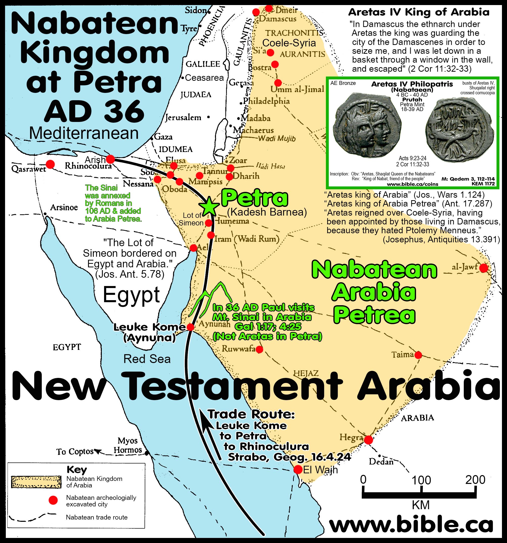
3. During Nabatean times (1st century) Elim was called Leuke Kome which is Greek for “White Harbor” also known as “White Village”.
a. It was a major seaport and the beginning of a caravan route through El Bad to Petra to Rhinocolura (Arish).
b. Two large rectangular storage buildings have been excavated validating the function of a sea to land shipping hub at the time of Apostle Paul.
c. Nabatean officials were stationed there in order to collect a 25% duty on all goods being imported.
d. We can now be certain that Leuke Kome was the western border town of the Nabatean kingdom in the first century and that Wilderness of Shur, Midian and Al Bad are in first century Arabia.
4. Bible texts:
a. "Then they came to Elim where there were twelve springs of water and seventy date palms, and they camped there beside the waters." Exodus 15:27
b. "Then they set out from Elim, and all the congregation of the sons of Israel came to the wilderness of Sin, which is between Elim and Sinai, on the fifteenth day of the second month after their departure from the land of Egypt." Exodus 16:1
c. "They journeyed from Marah and came to Elim; and in Elim there were twelve springs of water and seventy palm trees, and they camped there. They journeyed from Elim and camped by the Red Sea." Numbers 33:9
5. Little is known about Elim except:
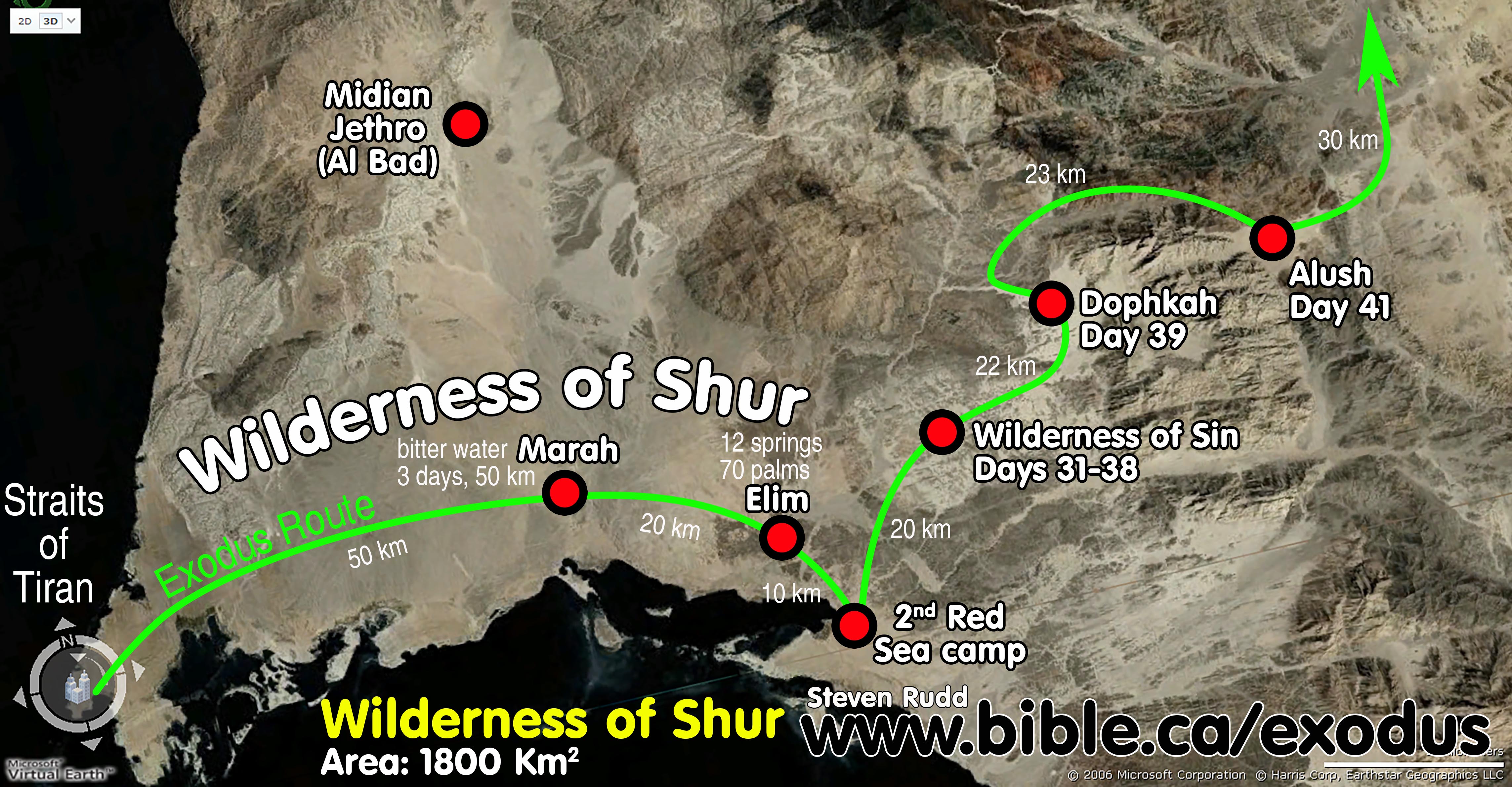
a. Marah and Elim are both in the Wilderness of Shur: "Then Moses led Israel from the Red Sea, and they went out into the wilderness of Shur Exodus 15:22
b. There were 70 date palms and 12 springs of water indicating an oasis.
c. The wilderness of Sin was located between Elim and Sinai.
d. There was a change of course at Elim. From Tiran to Elim the route travels east then makes a left turn north to pass through the Wilderness of Sin with Mt. Sinai directly ahead for the first time.
e. Elim, the Wilderness of Sin and Mt. Sinai are lined up geographically in a south to north row.
6. Keys in locating Elim:
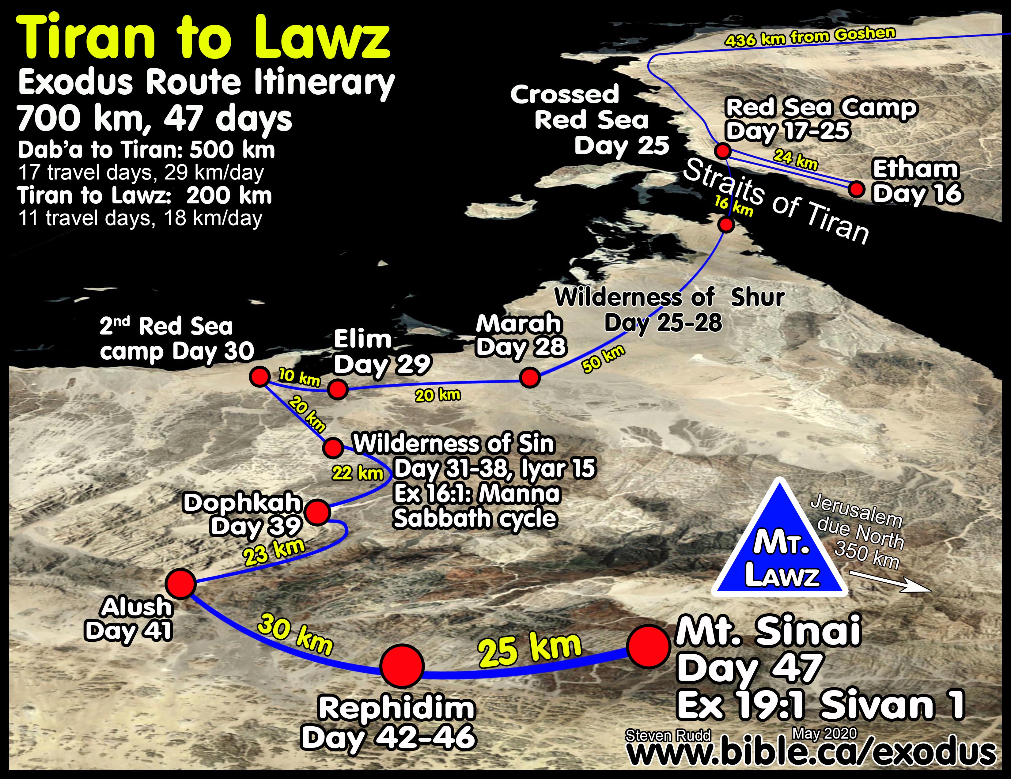
a. Elim was day 29 from Goshen and day 5 from the Red Sea crossing: Ex 16:1 (Wilderness of Sinai is day 31)
b. Geographically Elim is a 5-day journey from the Red Sea, but Israel likely travelled at a slower pace than before they crossed because the Egyptian army had been defeated.
c. There was only one Red Sea camp after crossing the Red Sea. This means that neither Marah or Elim were on the Red sea but must be inland enough to be isolated from the Ocean. If Israel travelled near the Red Sea coast for the first four days after crossing the Red Sea, the "second camp by the Red Sea" would make no sense. Every indication is that before they reached the second Red Sea camp after Elim, they were inland, to be not camping near the Red Sea.
d. The next stop after Elim is the second Red Sea camp.
7. Early Christians created metaphoric meanings for Elim: from ACC, Vol 3, p 83-84
a. “The wood that restores the sweetness to water is Christ” (Tertullian).
b. “The waters of baptism are of no avail unless the cross of Christ is preached” (Ambrose).
c. “The seventy palm trees remind us of Christ’s seventy disciples” (Jerome).
d. “The bitter water was the law of the Old Testament, which needed to be tempered by the cross of Christ” (Maximus of Turin).
e. “Marah and Elim stand in sharp contrast. Marah had one bitter spring; Elim had twelve sweet ones. This is a contrast between the law and the gospel (Maximus of Turin).”
f. The Contrast Between Marah and Elim. Maximus of Turin: They arrived at a place called Elim, where there were twelve very pure springs of water and a multitude of seventy flourishing palm trees. See the mystery of God—how, after the bitterness of the law, the richness of gospel piety abounds. There the one spring is harsh to drink, but here the many are all sweet to imbibe. Once there was no refreshment after weariness, but now there is refreshment after labor. For springs are at the disposal of the thirsty, and palms are offered to victors. Palms are offered to victors, I say, because after the hardness of the law it is a victory to have arrived at the grace of the gospel. For part of the victor’s reward is to moisten his mouth from a flowing spring and to take the triumphal palm in his hand. With the spring the confessor’s tongue is purified, and with the palm the martyr’s hand is honored—the former because it has praised the glory of Christ, the latter because it has refused the altar of sacrilege. Sermon 68.2.
g. The Meaning of Elim. Bede: When the people of God went out from Egypt, their sixth resting place, in which “there were twelve fountains of water and seventy palm trees,” was called Elim (that is, “of rams”), so that both by its name and by its appearance it might contain the figure of the apostles and the apostolic men. On the Tabernacle 2.4.
A. Elim provides several keys in decoding the exodus route:
1. Elim with 7 springs 3400 years ago might still have at least one or more active spring today. Elim at Ain Ounah (Anounah) is a perfect fit for a Tiran Red Sea crossing.
2.
Elim, the wilderness of sin and Mt. Sinai must be lined up in a direct
line-of-sight sequentially: Ex 16:1
a. This sequential order is an important marker most ignore in the Red Sea Route by positioning Elim closer to Mt. Sinai than the Wilderness of Sin.
b. This marker also shows that for the first time since crossing the Red Sea, Israel was walking directly towards Mt. Sinai.
c. This is a perfect fit for the Tiran crossing because it is at Elim, that Israel makes a 90 degree turn left and begins for the first time to be making the final approach to Mt. Sinai which is directly ahead in line of site.
d. The Nuweiba route of Glen Fritz has the order backwards because his Elim (located at Al Bad) is between the Wilderness of Sin and Mt. Sinai. His line-of-site sequential order is Wilderness of Sin, Elim, Mt. Sinai and this directly contradicts Exodus 16:1 which says, “the wilderness of Sin, which is between Elim and Sinai”. This is a serious problem he was unaware of or failed to address in any way and represents a dissonance between his Nuweiba route and scripture.
3. After crossing the Red Sea, the first major directional change in course was at Elim: Ex 16:1 “Sin is between Elim and Sinai”
a. From the Red Sea to Elim, Israel was travelling east. After Elim Israel was travelling north. The route turned 90 degrees left at Elim.
b. The sequential marker (Elim, Sin, Sinai) must indicate a change in course at Elim because if “between” merely means the next stop on the itinerary, then the wilderness of Sin is also “between” Mt. Sinai and Marah, Etham, Succoth. In the Itinerary, the wilderness of sin was “between” both Marah and Elim, yet Moses excluded Marah because there was no direct line-of-sight between Marah, Wilderness of Sin and Mt. Sinai.
c. The special notation that the Wilderness of Sin is between Elim and Mt. Sinai proves this is a geographic vector sequence and not merely an itinerary sequence.
d. The inescapable conclusion is that the reason Moses takes special care to note that the Wilderness of Sin was between Elim and Sinai, is because Israel made a 90 degree left turn at Elim and for the first time, was heading towards Mt. Sinai in line of sight.
4. Elim must be close enough to the second Red Sea Camp that they are connected in some way, yet, remain distinct stops.
a. In the Ex 16 narrative Moses routes directly from Elim to the Wilderness of Sin and skips the second Red Sea Camp. Moses included the second Red Sea camp in his detailed Num 33 itinerary, where the order is Elim, Second Red Sea camp, Wilderness of Sin.
b. The solution is simple. There is a direct easterly line of sight between Marah, Elim and the second Red Sea camp, but the Wilderness of sin was north of both Elim and the second Red Sea camp.
c. Walking southeast from Marah, Israel camped at Elim, then continued in the same southeast direction for 10 km to reach the second Red Sea camp. Leaving the Second Red Sea camp for the Wilderness of Sin, Israel travelled north, passing Elim closely on the left side. The compass bearing upon entering Elim (From Marah) was the same compass bearing from Elim to the Red Sea as one strait line.
d. In this way, the entire congregation left Elim, visited the Red Sea which was close to Elim, then passed Elim by on route north to the Wilderness of Sin.
e. Elim at the desert oasis of Ain Ouna is a perfect fit for the Tiran crossing and a fail for the Nuweiba crossing.
5. The Nuweiba route of Glen Fritz camps twice at Elim and features an unbiblical third Red Sea camp:
|
Nuweiba Crossing Failure: Second & Third Red Sea Camps Numbers 33:10 |
|||
|
TIRAN CROSSING |
NUWEIBA CROSSING |
||
|
Scripture: Tiran |
Glen Fritz southern route |
Alternate Northern Route |
|
|
Whole Group |
Main group |
Second group |
Whole Group |
|
Elim (Ain Ouna) |
Elim |
Elim |
Elim |
|
Second Red Sea camp (Num 33:10) |
***Missing*** |
Second Red Sea Camp |
***Missing*** |
|
Wilderness of Sin |
Wilderness of Sin |
Elim |
Wilderness of Sin |
|
Dophkah |
Third Red Sea Camp |
Wilderness of Sin |
|
|
|
Dophkah |
Third Red Sea Camp |
|
|
|
|
Dophkah |
|
|
PERFECT FIT |
FAIL |
FAIL |
FAIL |
a. Fritz knows his southern route to Mt. Sinai after crossing at Nuweiba is deeply flawed because it provide no logical opportunity or solution for a second red sea camp as scripture says. The same failure is true for those who cross at Nuweiba then take the northern route to Mt. Law. Fritz knows from Numbers 33:10 that there must be second Red Sea camp between the Nuweiba crossing and one stop before the wilderness of Sin. So he is forced to fabricate a fictional itinerary where the larger group went directly from Elim to the Wilderness of sin but a smaller group went from Elim to the second Red Sea camp, then back to Elim, then the Wilderness of Sin, then off to an unbiblical third Red Sea Camp. In Fritz’s fiction, neither group follow the inspired itinerary recorded by Moses of Elim, second Red Sea camp then the Wilderness of Sin. In Reality, there were three groups in the Fritz fiction: After camping at Elim (Al Bad) one group heads for the Wilderness of Sin, a second group heads for the Red Sea at Maqnah and a third group camps an additional two days waiting for those who went to the Red Sea to return.
b. Fritz’s route contradicts the Bible by rearranging the sequence of stops so that Elim is visited twice: Marah, Elim, 2nd Red Sea camp, Elim, Wilderness of Sin, unbiblical third Red Sea Camp. Fritz is to be praised that he the is the only proponent of the Nuweiba crossing that even tries to have a second Red Sea camp after crossing at Nuweiba. The Fritz route takes Israel from Elim at El Bad, west to the Gulf of Aqaba, then “backtracks” to Elim, then south to the Wilderness of Sin. Strange that Fritz has no backtrack at Etham where scripture requires it, but then adds a backtrack at the second Red Sea camp which contradicts scripture. Fritz’s backtrack adds on additional two days to his itinerary which he desperately needs to reach Mt. Sinai in 47 days as per Ex 19:1.
c. In Fritz’s fictions and fabrications, none of his groups follow the inspired itinerary recorded by Moses from Elim to the second Red Sea camp to the Wilderness of Sin and finally to Dophkah.
d. The Tiran route marks the second Red Sea camp after Elim according to the Bible, at the identical location the Fritz-Nuweiba route marks an unbiblical third Red Sea camp after the Wilderness of Sin and before Dophkah.
6. Fritz rationalizes the otherwise absurd two day journey from Elim (Al Bad) to the Gulf of Aqab (Maqnah) by suggesting the Hebrews were motivated to collect the debris from the Egyptian army after they drowned in the sea the week before. He is also forced to define Elim like a large wilderness area as opposed to a single location in spite of the fact the Bible said it had 7 springs and 70 date palms. Glen Fritz own words: comments in [square brackets] added:
a. “Elim was likely a large district in the Wadi al-‘Ifal area of Al-Bad’. Elim may have extended into Wadi Ḥamḍ. … Due to the immense size of the Exodus multitude, Elim should be envisioned as a
b. large, spread out district.” (Exodus Mysteries, Glen Fritz, p376, 387, 2019 AD)
c. “The continuation to Yam Suph, 30.5 km (19 mi.) from the Al-Bad’ part of Elim, is a bit of a conundrum because it amounted to a significant deviation from the net course of the journey to Mount Sinai. It was essentially a dead end destination with limited potable water and encampment space.” (Exodus Mysteries, Glen Fritz, p391, 2019 AD)
d. “A “contingency” [smaller group 2 who went from Elim, Maqnah, Elim, Wilderness of Sin] of the Hebrews continued to the shore of Yam Suph near present day Makna, 30 km (19 mi.) from Al-Bad’. A “contingency” [smaller group 2] is suspected rather than the entire multitude [larger group 1 who bypassed Maqnah and wend directly to the Wilderness of Sin from Elim], because this encampment was only listed in the Numbers 33 itinerary; it was not mentioned in the Exodus 16 itinerary. Practically speaking, the entire multitude could not easily encamp at the sea in the Makna area due to terrain and water limitations. At Yam Suph, the Hebrews happened upon the wreckage of the Egyptian army strewn along the coast, which had drifted 64 km (40 mi.) south from the site of the sea crossing debacle a week earlier. This providential circumstance allowed them to salvage weapons and other useful objects transported from Egypt for them by thousands of troops and hundreds of chariots. The multitude moved south from the Yam Suph and Elim encampments into the adjacent Wilderness of Sin, arriving about 10 days after the sea crossing exit and one month after leaving Egypt (Exo. 16:1).” (Exodus Mysteries, Glen Fritz, p469, 2019 AD)
e. “However, the initial arrival of the multitude in the Wilderness of Sin likely preceded the hundreds of thousands trailing behind by several days.” (Exodus Mysteries, Glen Fritz, p399, 2019 AD)
7. In Ex 16:1, the entire congregation arrived as a single group at the Wilderness of Sin on the same day.
a. This was day 31 from Goshen: Saturday, 15th day of the 2nd month, Iyar 15.
b. The reason this is critical, is because it was on Lyar 15 (a Saturday) that Moses first revealed the 7-day Sabbath/Manna cycle in the Wilderness of Sin. They learned that Manna would fall for six days: Sunday to Friday, which a double portion on Friday. Then Saturday, the 7th day, they were to rest and no Manna would fall. It is important that Israel arrived as a single group on a Saturday so they could all learn together about the Manna/Sabbath cycle.
c. The Glen Fritz Nuweiba crossing route splits the 3 million Hebrews into two groups when they first arrive at Elim (Al Bad). One group continues south to the Wilderness of Sin, arriving on Lyar 15 (Ex 16:1), while the second group travels one day through narrow canyons to modern Maqnah on the Gulf of Aqaba as the second Red Sea camp. This group retraces their steps back to Al Bad (Elim) then south to the Wilderness of Sin. The first group arrives at the Wilderness of Sin on Lyar 15 (Day 31) but the second group arrives two full days later on Lyar 17 (Day 33). This second group not only missed Moses’ instructions about the Sabbath/Manna cycle, for them, Quail suddenly appeared in the evening while they were at the second Red Sea camp, then the next day Manna suddenly appeared without explanation from Moses who was two days ahead. They then arrived at Elim on the second day of Manna while they camped for the second time at Elim on Monday. By the time the second group finally got to the Wilderness of Sin on Tuesday (the third day of Manna), the first group had already moved and were still two days ahead between Dophkah and Alush. The first group to arrive at the Wilderness of Sin experienced quail that same evening and Manna in the morning because they grumbled but the second group probably missed all this, being two days of travel away. This directly contradicts Ex 16:1-2 which twice says “all the congregation arrived” and “the whole congregation grumbled about food” the same day.
d. The Tiran route is a perfect fit for the entire 3 million Hebrews arriving at the Wilderness of Sin together as a single group on the same day.
8. In Ex 17:1, Israel camped a full 8 days at the Wilderness of Sin as a single group to learn the Sabbath/Manna cycle before moving to Dophkah.
a. Israel camped 8 days (days 31-38, Lyar 15-22), Saturday to Sunday, at the Wilderness of Sin then left for Dophkah the following Sunday.
b. "THEN all the congregation of the sons of Israel journeyed by stages from the wilderness of Sin, according to the command of the Lord, and camped at Rephidim" (Exodus 17:1)
c. The key is that only after all the events in chapter 16 had occurred “THEN” all the congregation left the Wilderness of Sinai.
d. Glen Fritz completely misses this important 8-day camp at the Wilderness of Sin to learn the Sabbath/Manna cycle and allows only one camp day at the Wilderness of Sin. Fritz splits the congregation up into two separate travel groups, two days apart. The first group arrives at the Wilderness of Sin on Lyar 15 as per Ex 16:1, then leaves for the unbiblical “third Red Sea Camp after only one camp day, then continuing to Dophkah. The second group arrives at the Wilderness of sin two days later on Lyar 17, completely missing Moses’ instruction about the Manna/Sabbath cycle while the first group has already moved from Dophkah and is arriving at Alush.
e. The Tiran route is a perfect fit but the Fritz’s Nuweiba route directly contradicts scripture.
9. Marah is the closest Israel will come to Midian as they wind their way around the west side of Mt. Sinai.
a. The first time Jethro joins Moses was at Rephidim, which was one stop before arriving at Mt. Sinai.
b. Glen Fritz has Israel cross the Red Sea at Nuweiba then camp at Al Bad (Midian) as his Elim for two days. Not only is this contradicted by Jethro’s visit at Rephidim with no mention of Jethro at Elim, Fritz’s route merges with the Straits of Tiran Red Sea crossing route.
c. If the actual exodus route passed directly through Midian, the hometown of Moses’ and Jethro’s, there would have been some notation by Moses.
d. Most obvious is that if Moses camped up to three days at Midian, he would not have called the location Elim! He would have called it Midian in the Num 33 Itinerary list. Fritz’s choice for Elim at Midian contradicted by Jethro’s first visit at Rephidim
10. The difficult Nuweiba route intersects and Merges with the easier Tiran route:
a. Fritz’s Nuweiba route merges at the Wilderness of Sin (Fritz) with the Straits of Tiran Red Sea crossing route after Elim (Fritz) to become the same route until the second Red Sea camp. The Fritz Nuweiba route arrives on day 31 at the same geographic location where the Tiran route intersects on day 26. This intersection point is south of Al Bad. The two routes unite even though the stop names are different until the Fritz route arrives at his third Red Sea Camp. Of course, this is the same location for the second Red Sea camp of the Tiran route but the third Red Sea camp for Fritz’ Nuweiba route. From this point to Mt. Sinai the two routes split apart.
b. Overall, the Tiran route over all shorter in both distance and time and has much easier terrain than the Nuweiba Route. The Tiran Route is shorter, faster and easier than Nuweiba. Nuweiba is 25% longer in distance, 18 days longer (not including 15 missed camp days) and 400% more difficult than the Tiran route.
c. The Elephant in the room is if the two routes merge south of Al Bad, why don’t those who promote the more difficult Nuweiba crossing simply adopt the simpler Tiran crossing route?
|
Summary comparison of Tiran vs. Nuweiba Red Sea Crossings |
||
|
|
Tiran: Rudd |
Nuweiba: Fritz |
|
Total days Goshen to Sinai |
47 days (including 8 days waiting for pharaoh and 8 days at the Wilderness of Sin) |
64-65 days with zero days waiting for pharaoh and only 1 day at the Wilderness of Sin. Fritz says 61 days to the Wilderness of Sinai and 3-4 more to Mt. Sinai. |
|
Goshen to Red Sea |
294 miles/490 km |
272 miles/435 km |
|
Red Sea Crossing |
10 miles/16 km |
10 miles/16 km |
|
Red Sea to Sinai |
156 miles/260 km |
273 miles/437 km |
|
Goshen to Sinai |
450 miles/750 km |
555 miles/888 km |
|
Total narrow canyon travel |
30 miles/50 km |
171 miles/273 km |
|
% of narrow canyon travel |
7% (30/450) |
31% (171/555) |
|
% distance difference |
Nuweiba is 25% longer in distance than Tiran (450/555) |
|
11. Only a Red Sea crossing at Tiran satisfies all these keys whereas the Nuweiba crossing of Glen Fritz fails.
B. Timing and distances:
![]() Travel
times, distances, days of the week
Travel
times, distances, days of the week
Israel arrived at Elim on Thursday, day 29 from Goshen and day 4 from the Red Sea crossing. Elim is 20 km from Marah and it is 10 km to the second Red Sea camp.
C. Nabatean archaeology of Elim (Leuke Kome) in the first century:
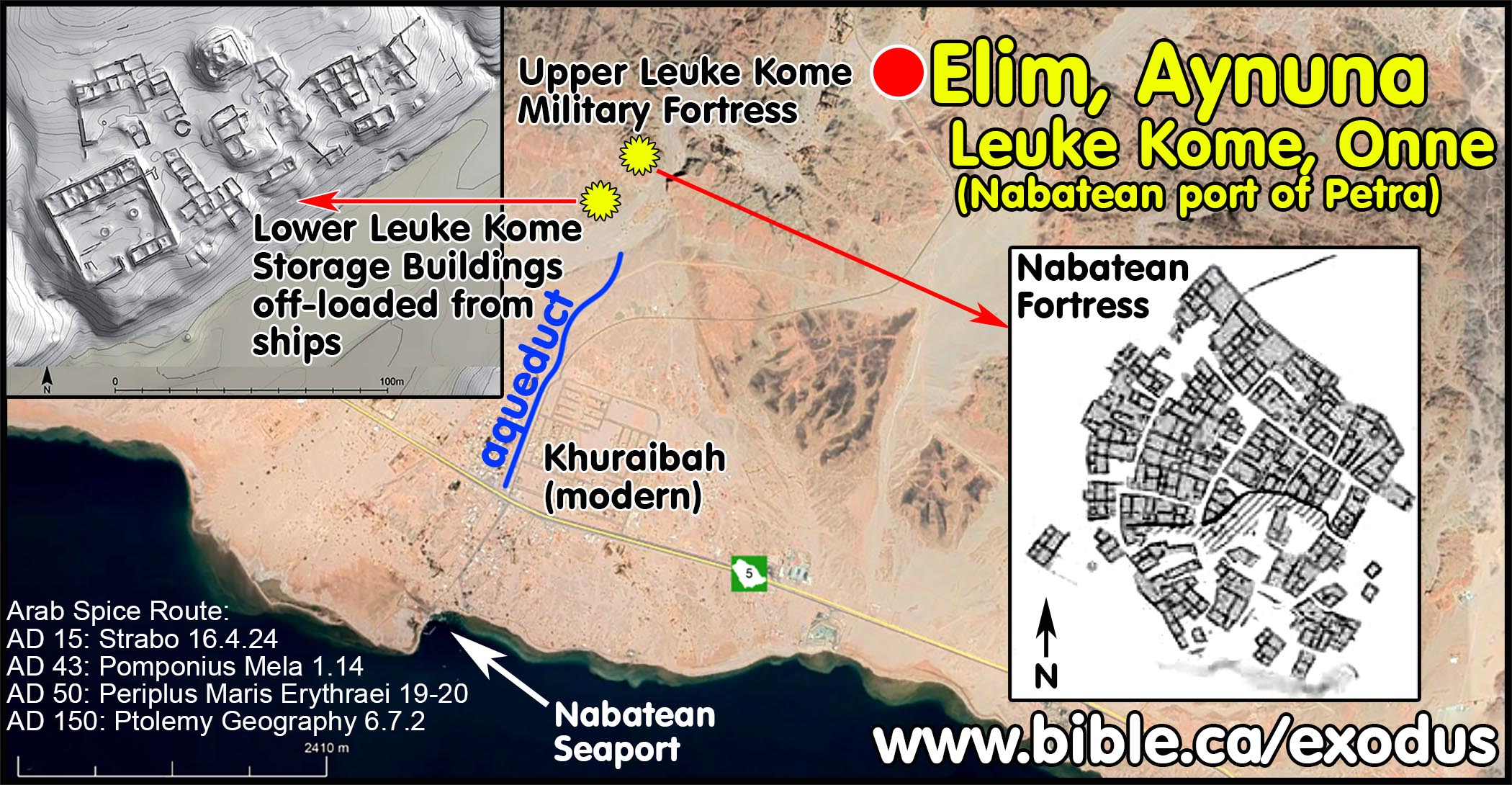
1. Leuke Kome was the Nabatean port city for Petra. Goods from southern Arabia and India would arrive by ship and were offloaded. Strabo described how goods were transported from Arabia to the port city of Leuke Kome, which is the Biblical Elim at Ain Ounah (Aynuna) to Petra then Rhinocolura. Ancient maps (c. AD 1600) may have called it “Onne or Omne”. A 25% tax was levied by the Nabatean official and the goods were then transported overland by camels to Petra then to Rhinocolura (Arish). The Nabateans controlled this seaport at Arish, which was the ancient border between Egypt and Israel.
a. In the Exodus, Elim is the same location as Nabatean Leuke Kome and modern Ain Ounah (Aynuna).
b. “Merchandise is conveyed from Leuce-Come to Petra, thence to Rhinocolura in Phœnicia, near Egypt, and thence to other nations. But at present the greater part is transported by the Nile to Alexandreia. It is brought down from Arabia and India to Myus Hormus, it is then conveyed on camels to Coptus of the Thebais, situated on a canal of the Nile, and to Alexandria.” (Strabo, Geography 16.4.24)
c. “Eudaimon Arabia [Arabia Felix] is bounded on the north by the designated border of Arabia Petraia [Arabia Petra] and of Arabia Deserta; on the northeast by a part of the Persian gulf; on the west by the Arabian gulf; on the south by the Red Sea; on the east by that part of the Persian gulf and the sea, which extends from the entrance to this gulf as far as the Syagros promontory. The [north-west] coast of this region is as follows: after the border of the Arabian gulf in the inmost part of the Elanite gulf [Gulf of Aqaba], Onne 66°20' [Leuce Come]. 28°50'; Modiana or Modouna [Not same as Midian], but south of Onne on coast] 66°40' . 27°45'” (Claudius Ptolemy, Geography 6.7.1-2, translated by Brady Kiesling, 150 AD)
2. Sailors refused to sail their goods up the Gulf of Aqaba to the port at Elat (Ezion Geber) because of dangerous and unpredictable seas. The direction of prevailing winds made it difficult to sail directly up or down the Gulf of Aqaba. The Gulf of Aqaba was also notorious for pirates who would steal the cargo and sell the crew as slaves.
a. “After sailing past this country, one encounters the Laeanites Gulf [Gulf of Aqaba] around which there are many villages [Al-Bad/Midian] of the so-called Nabataean Arabs. They occupy much of the coast and not a little of the adjacent country which extends into the interior and contains a population that is unspeakably great as well as herds of animals that are unbelievably numerous. In ancient times they led a just life and were satisfied with the livelihood provided by their flocks, but later, after the kings in Alexandria had made the gulf [of Aqaba] navigable for merchants, they attacked those who suffered shipwreck. They also built pirate vessels and plundered sailors, imitating the ferocity and lawlessness of the Tauri in the Pontus. But later they were caught at sea by quadriremes and properly punished. (Agatharchides of Cnidus, On the Erythraean Sea 169 BC, translated by Stanley M. Burstein, 1989, book 5, fragment 90a. Diodorus 49 BC, 3.43.1-5)
b. “The land next the sea is similarly dotted here and there with caves of the Fish-Eaters, but the country inland is peopled by rascally men speaking two languages, who live in villages and nomadic camps, by whom those sailing off the middle course are plundered, and those surviving shipwrecks are taken for slaves. And so they too are continually taken prisoners by the chiefs and kings of Arabia; and they are called Carnaites. Navigation is dangerous along this whole coast of Arabia, which is without harbors, with bad anchorages, foul, inaccessible because of breakers and rocks, and terrible in every way. Therefore we hold our course down the middle of the gulf and pass on as fast as possible by the country of Arabia until we come to the Burnt Island; directly below which there are regions of peaceful people, nomadic, pasturers of cattle, sheep and camels.” (Periplus Maris Erythraei 20, AD 50)
3. Archaeological excavations confirm Leuke Kome was a major Nabatean trade route port. It was located 3 km north of a large, safe seaport. The site features a large military fortress made of mudbricks and a large mudbrick storage complex for goods off-loaded from ships. A ceramic aqueduct transported fresh water 3 km from the buildings down to the seaport. There are a cluster of 7 archaeological sites located between the seaport and the mudbrick fortress that include a Nabatean cemetery.
a. “'Aynunah is one of the ancient settlement sites northwest of the Kingdom. It contains some antiquities that date back to the Nabataean period and the early Islamic period. It lies in the vicinity of a well-known Nabataean port called Leuke Kome. 'Aynunah was also one of the caravansaries on the Egyptian coastal route. Al-Yaqubi mentioned it in the third century after hijrah (9th century A.D). He wrote "whoever wants to depart from it (Midian) to Makkah, has to arrive on a place at the coast of the salted sea called 'Aynunah. In 'Aynunah there are buildings, palm trees and gold mines"” (Al-Bid, Ansary, p41, 2002 AD).
b. “Archaeologically Leuke Kome has been identified as a cluster of seven inter-related settlements in the region of Aynuna in Saudi Arabia, c. 5 km from the coast at the mouth of the Gulf of Aqaba (Ingraham et al. 1981: 76–8). Although known only through survey, extensive architecture is visible at two of the complexes, including a standing tower; nearby is a large necropolis. It seems that during the first century ad there was some decline in the use of Leuke Kome as a result of the ascendancy of the Egyptian maritime routes, but that it continued to play a role in the still robust overland trade (Young 2001: 100, 103–4). Leuke Kome is described in the mid-third-century Monumentum Adulitanum (Chapter 4, 88–9), which implies that it was still active at that time as part of Provincia Arabia. A reference by Marcianus may extend the occupation until ad 400 (Ward 2002: 115). Surface pottery from Aynuna included Nabataean wares (Ingraham et al. 1981: pls 82, 86), but no Egyptian or Eastern ones can be identified from the literature. Petra, the capital of Nabataea and an important caravan site, has, on the other hand, been intensively excavated and published. To date, Gogte (1999) has identified a mould-decorated pot similar to Hellenistic ones, like those made in western India (Begley 1992: 157–76). There is a potential for the recovery of further Indian and Arabian finds from these sites, which will help to clarify their role on the wider maritime stage.” (Indo-Roman Trade: From Pots to Pepper, Roberta Tomber, p68, 2012 AD)
c.
“The wadi runs about 4 km inland and
sites are clustered on both sides. No traces of ancient structures except for
some ruins of a water conduit of unknown date can be observed in the port of
Khoraiba [see Fig. 2]. The 19thcentury seafarers’ accounts paint a picture of
humble buildings of mud brick and reed (Wellsted 1838: 162–163; Burton 1878:
133–137). Just where the wadi comes down from the inland plateau, on the right
(western) bank, there is a group of buildings typical of structures used for
the storage of goods. This complex, currently investigated by a Polish–Saudi
team, may have been an emporium located close to the port. Its location in the
northernmost regions of the Red Sea make Aynuna and excellent stop on the land
route connecting Nabatea with the rest of Northern Arabia while avoiding at the
same time the hardships of the Gulf of Aqaba. A relatively good road,
approximately 300 km long, ran from the Red Sea through Wadi ‘Ifal to Aqaba and
farther on along the Wadi Arabah to the Nabatean capital of Petra [Fig. 5]. The
route through Wadi ‘Ifal was used also in the Islamic period, as part of the
“Egyptian Pilgrim Route” to the Holy Cities. It crossed the mountains, but was
relatively easy and safe for caravans. Stopovers, with fresh water available,
were at Haql, Al Sharaf, Al Bad and in Wadi Aynuna. The stretch of the route
between Aqaba and Petra was well known as Via Nova Traiana and was used by the
Roman army. Assuming that a fully loaded camel can make 30– 40 km per day
(Seland 2015: 46), a caravan moving from the Red Sea must have taken 8–9 days
to reach Petra.” (The port of Aynuna in the pre-Islamic period: nautical and
topographical considerations on the location of Leuke Kome, Karol Juchniewicz,
Polish archaeology in the Mediterranean, p36, 2018 AD)
4. Upper Leuke Kome military fortress:
a. “This site is about 2.5 kilometres north of al-Khuraibah. One can reach the site across an unpaved track in Wadi 'Aynunah. The site consists of a settlement area and spread in an area of about 500x500 meters. This important settlement lies at the edge of Wadi 'Aynunah around its water spring. A large number of fine Nabataean eggshell wares were found here, therefore the site could be attributed to the Nabataean period.” (Al-Bid, Ansary, p42, 2002 AD)
b. “Now to the left of Berenice, sailing for two or three days from Mussel Harbor [Myos Hormos] eastward across the adjacent gulf, there is another harbor and fortified place [military fortress], which is called White Village [Greek = Leuke Kome], from which there is a road to Petra”” (Periplus Maris Erythraei 19, 50 AD)
5. Lower Leuke Kome storage buildings:
a. “The archaeological remains consists of a ceramic water qanat, and slight! high and dunes in which there are foundation of stonewalls spreading in an area of 400x600 meters. The site is about 20 metres above sea level. The old water qanat can be traced to a distance of 300 meters in north-south orientation. It is made of ceramic in semi cylindrical shape and is fixed with mortar on stone foundation. It represents a developed irrigation system. The qanat appear at levels proportional to the earth surface. In certain areas, it is half a meter in height. The width of the qanat is 20cm at the base and 40-50cm on the exterior. There is also an Islamic cemetery on the site. Various types of Nabataean and Islamic potsherds were found including the painted and fine Nabataean eggshell wares. Thus, the site can be dated to the Nabataean and the early Islamic period.” (Al-Bid, Ansary, p41, 2002 AD)
b. “A very preliminary analysis of the pre-Islamic ruins in Wadi Aynuna leads to the conclusion that the cluster of buildings in Lower Aynuna functioned as a storage facility for goods brought to the port at Khoraiba by ship. Once on shore, they were transported by camel caravans to Aila/Aqaba and then to Petra. Still, there are issues to be considered. Why should a storage facility be located 3 km away from the port and why in the first place goods would have been stored there instead of being shipped on smaller vessels further north to the port of Aqaba? Accessibility of water and pastures for camels is the simplest answer to the first question. Both were easily available in the valley of Aynuna and the caravan station would have been located halfway between the port and the camel pastures. Moreover, the site was protected by the nearby settlement in Upper Aynuna. Regarding the second issue, two factors come into play: time and risk. Sailing conditions in the Gulf of Aqaba, with the sudden gales that could last for days, coupled with treacherous reef-lined shores made the journey fraught with danger. In 1833, it took the British ship ss. Palinurus under Captain Robert Moresby six days to sail from the mouth of the Gulf to Aqaba and that only on the second try. Moresby spent four years charting the northern part of the Red Sea for the East India Company and he had no doubt that the Gulf of Aqaba was dangerous to sail. Lateen/settee rigged vessels, known probably as early as the 2nd century AD (Whitewright 2009: 102) were capable of sailing even in such a narrow stretch of sea, although it might have been regarded as risky and time consuming. The inland trade route through Wadi ‘Ifal cut by half the time to reach Petra and was perfectly safe. Decisions in this regard would have been business-driven and safety-oriented for sure. Sailing all the way to Aqaba is another issue to be considered. The Periplus, whether by mere chance or not, speaks of Leuke Kome and not Aqaba/Aila, which is clearly the port of Petra. Aqaba/Aila is not even mentioned there. It seems to have been of minor importance for international trade, possibly because of the risky location in terms of navigation. Aynuna/Khoreiba however was the last safe point on the way from the south, still ensuring fairly comfortable sailing conditions. The real challenge started in the Tiran Strait. The port of Aynuna with its excellent anchorage and its safe and easy connection via an inland route to the rest of the Nabatean kingdom, allowed this dangerous stage of the voyage to be avoided. Modern accounts of sailing conditions in the Gulf of Aqaba indicate that caravans could reach Petra in half the time and without any additional risk. Identifying Leuke Kome has been the topic of numerous scientific discourses and it is beyond the scope of this paper to study the pros and cons of all the diverse views and arguments. What should be pointed out in this context is the topographical question. Generally speaking, two locations of Leuke Kome are considered: Aynuna and El Wajh. The most important source for Red Sea topography is definitely the Periplus Maris Erythraei where Leuke Kome is clearly described as the “port of Petra”. There would be no reason for merchants to stop in El Wajh and take a roundabout route through the Hegra, which incidentally is not mentioned at all, to reach Petra, when Aynuna offers a good and safe anchorage, and an excellent connection with the capital of the Nabateans. The only advantage of El Wajh, and a contested one at that, is its situation opposite Qusair/Myos Hormos, corresponding thus to the description in the Periplus, which says that Leuke Kome is to the east of this port. However, while the Periplus seems to be quite accurate in its descriptions, it shows a surprising generality in the case of Leuke Kome: an approximate distance (“two or three days sailing”) and not very exact directions (“to the left of Berenike”). Moreover, there is no mention of the goods that were traded in this port, a component usually present in descriptions of other ports. It has been recently argued that the author of the Periplus had never been in Leuke Kome personally, making his description of the harbor unreliable at best (Bukharin 2012: 110–124). No material indicating Nabatean presence in El Wajh has been recorded so far, while the temple at Wadi Hamd, found by Burton, is too far away ("one long or two short marches", Burton 1879: 220 ) to be linked with the port and was rather part of the main route connecting this part of the coast with Al Hijr (ancient Hegra, modern Mada’in Saleh), an important Nabatean city in the interior. The author of the Periplus expectedly did not mention Hegra as it would have been a major land stop on the way to Petra. The subordinate route from El Wajh went 50 km south before turning east–northeast toward the desert city. The location of Aynuna on the contrary suits most of the topographical directions regarding Leuke Kome in the Periplus and given by Strabo (Gawlikowski forthcoming). The safe anchorage and the convenient land connection with Petra make Aynuna a strong contender for identification with ancient Leuke Kome. (The port of Aynuna in the pre-Islamic period: nautical and topographical considerations on the location of Leuke Kome, Karol Juchniewicz, Polish archaeology in the Mediterranean, p38, 2018 AD)
6. AD 50 Periplus Maris Erythraei describes Leuke Kome as a Nabatean port:
a. The Periplus Maris Erythraei means “The Voyage around the Erythraean Sea” and was written around AD 50 by a Greek sailor on the Arabian trade route from Egypt to India.
a. Leuke Kome (Greek for “White Harbor”) is located at Ain Ounah, which is also Biblical Elim of the Exodus.
b. The Greek sailor wrote at the time of Paul that “Arabia” was to the south of the Gulf of Aqaba down the entire length of the coast of the Arabian Gulf. He excluded the Sinai Peninsula from his definition of where Arabia was located.
d. “The Periplus Maris Erythraei is a document of vital importance in the study of the Roman Red Sea trade with Arabia, India and Africa, which gives us a rich source of information on the trading routes and practices of Roman merchants in the Red Sea and Indian Ocean at the beginning of our era. In the course of his description of the Arabian trade, the author of the Periplus gives passing mention to the port of Leuke Kome, from which goods were transported to the Nabataean capital of Petra. In the course of this description, an intriguing reference is made to the presence at Leuke Kome of a customs-officer of the reraprr] (a 25% tax on incoming goods) and a centurion. … According to Strabo, Leuke Kome was a part of the Nabataean kingdom at the time Aelius Gallus' expedition to Arabia Felix arrived there in 25 B.C., and was at that time a substantial market and port for the incoming incense trade from southern Arabia (Strabo Geogr. 16.4.23). In later years, however, it would seem that this trade died off to some extent (Geogr. 16.4.24), although the citation from the Peri plus above clearly indicates that trade continued to pass through Leuke Kome in the middle of the first century A.D., the time that the Periplus was written.” (The Customs-Officer at the Nabataean Port of Leuke Kome, Periplus Maris Erythraei 19, Gary K. Young, Zeitschrift für Papyrologie und Epigraphik, p266, 1997 AD)
D. How the traditional choice for Elim fails:
- The Bible says they exited the Red Sea when to Marah and Elim, then camped beside the Red Sea again. This means that Marah and Elim were not beside the Red Sea but somewhere inland. The traditional location on most Bible maps for the Marah and Elim are on the east coastal plain of the Red Sea. The coastal flat is only about 10 km wide at this point.
- Because traditional route has Israel traveling down the east side of the Gulf of Suez in a narrow coastal plain, all three locations (Marah, Elim, second Red sea camp) are by the Red Sea. This makes no sense because Marah and Elim should not be near the Red Sea or else the narrative saying they left Elim and camped by the Red Sea is nonsense. If this was the case it would say they left the Red Sea and camped again by the Red sea at Marah, and left Marah and camped by the Red Sea again at Elim, then left Elim and camped by the Red Sea.
E. Photos and maps:
|
Elim, even today the springs support many trees in the middle of a dry desert. |
|
|
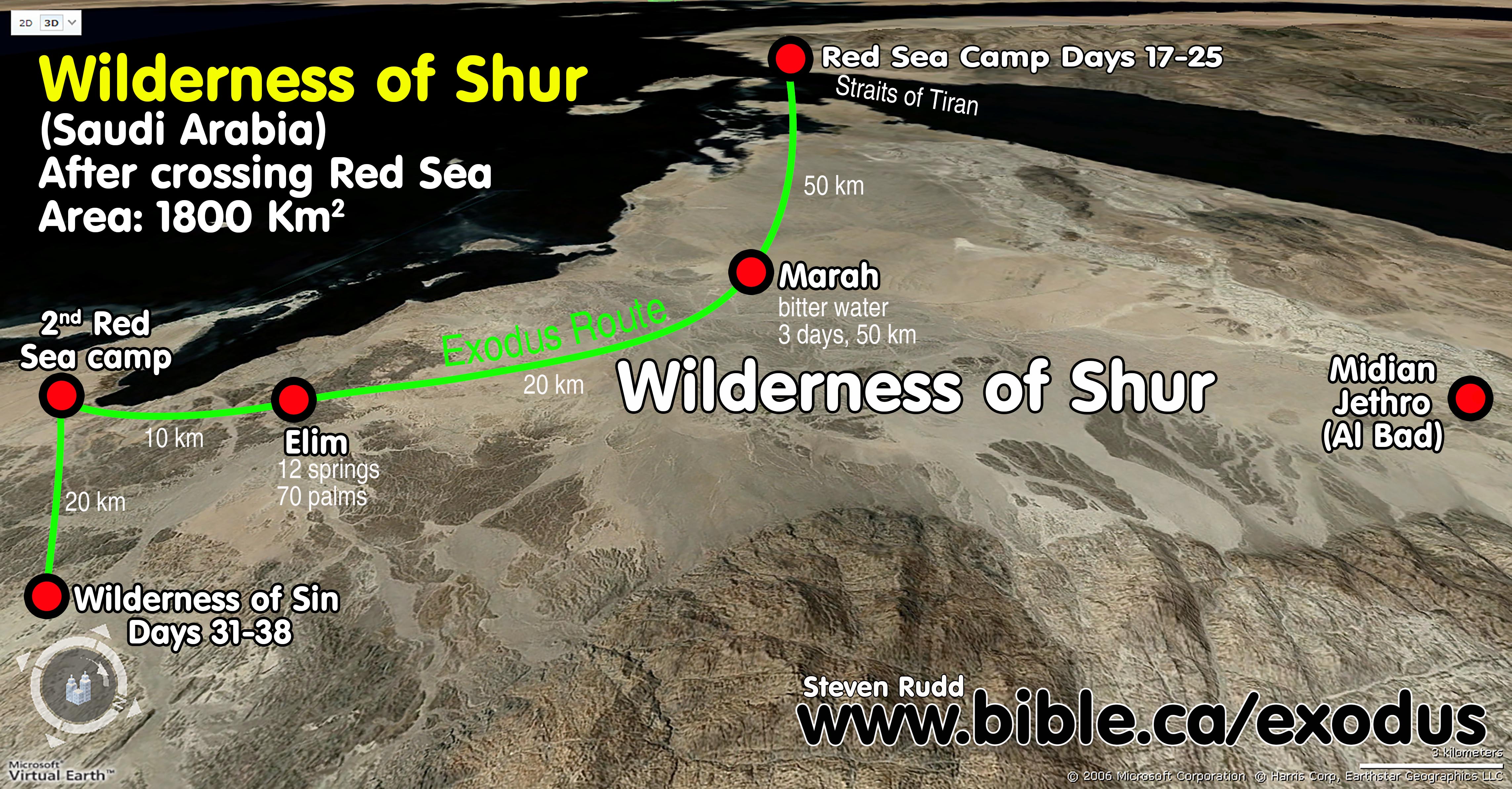
Aerial view of the wilderness of Shur and the exodus route. |
|
|
Terrain looking south to the Wilderness of Sin. |
|
|
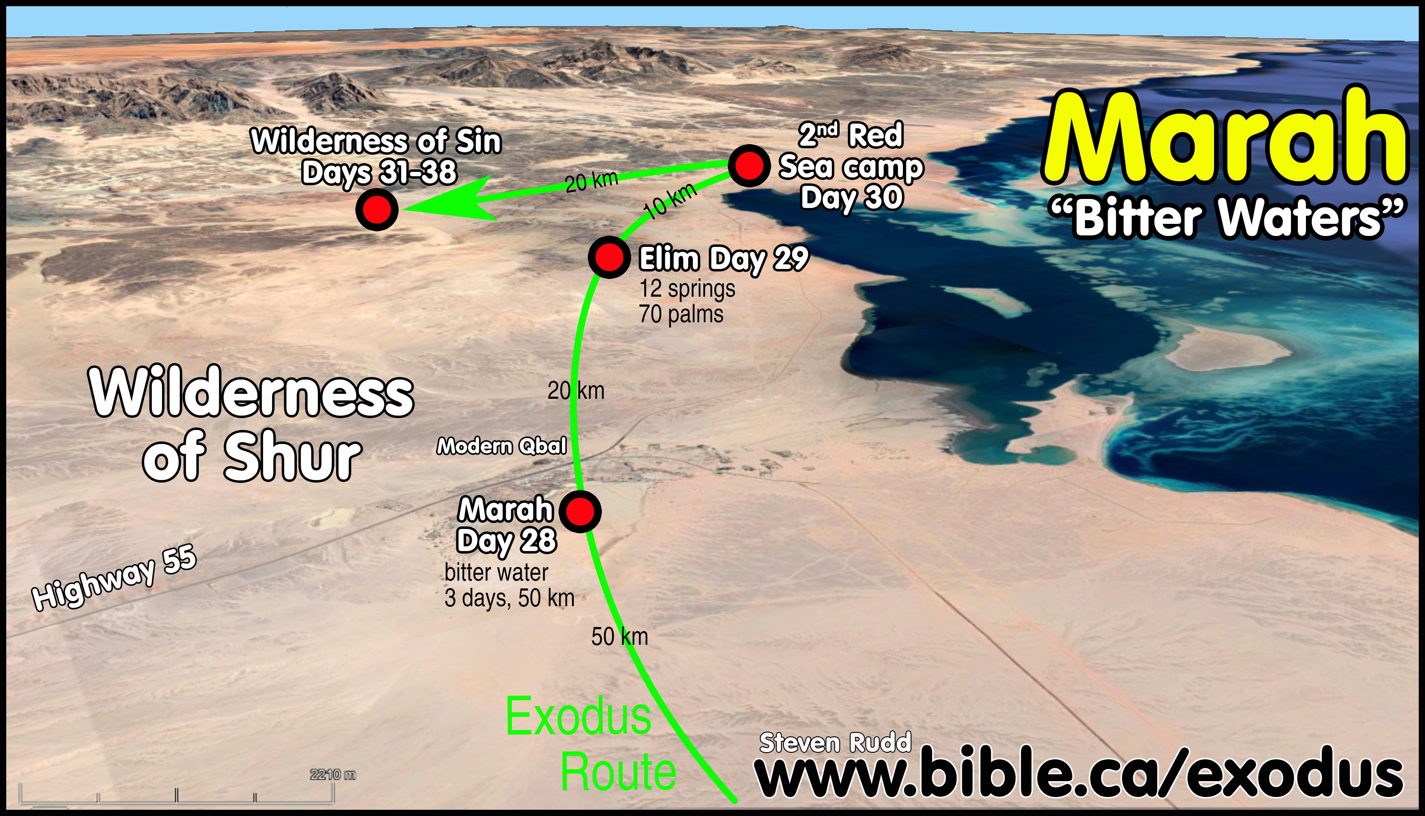
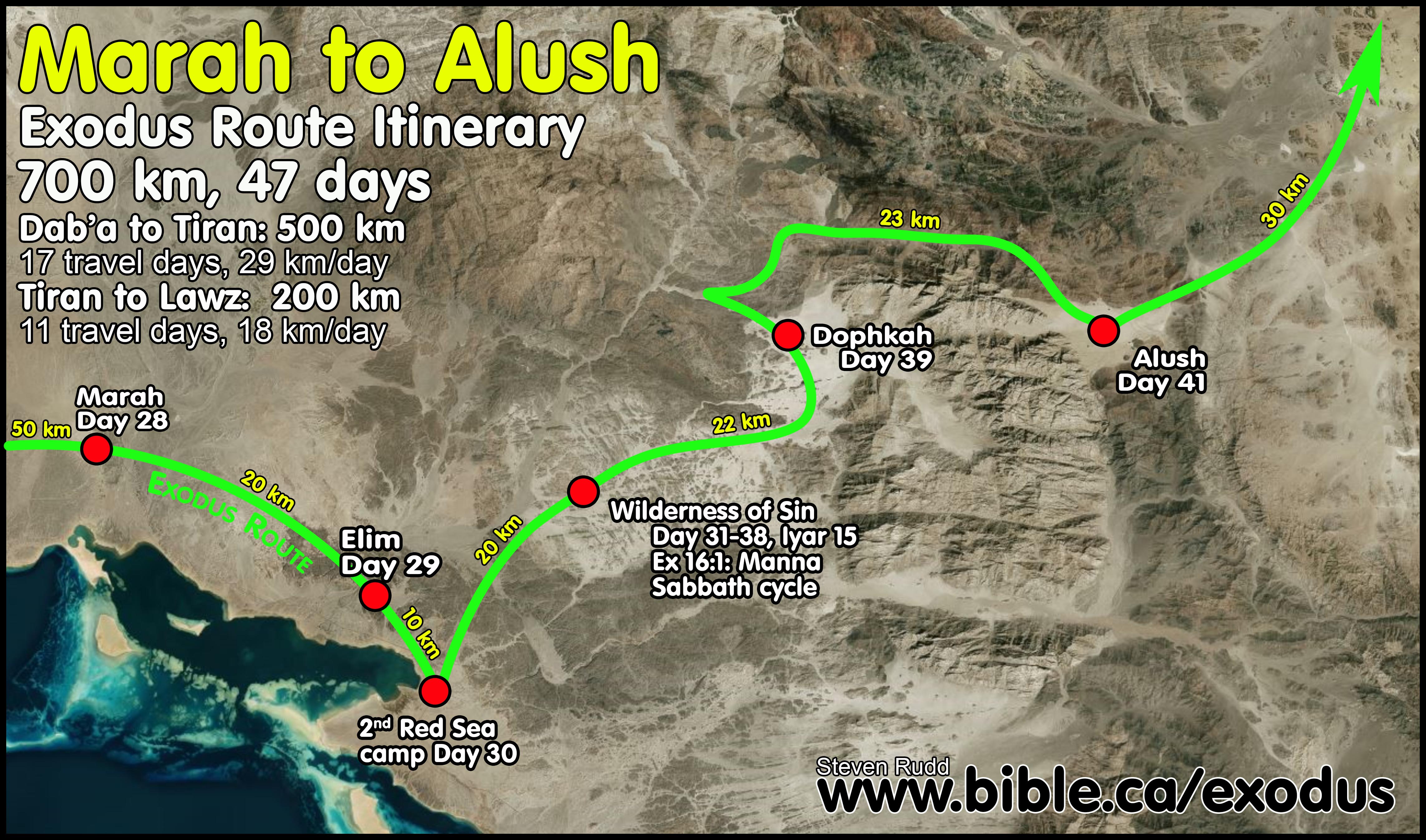
Exodus route from Marah to Alush. |
|
|
Marah and Elim which are both in the wilderness of Shur. Distances are indicated from each stop. |
|
By Steve Rudd: Contact the author for comments, input or corrections.
