The Exodus Route: Marah
|
|
Marah (bitter waters) |
|
|
|
|
|
Exodus locations:
|


Introduction:
1. The location would be somewhere with a natural water supply that was bad for some reason.
2. We have no idea why the water was “bitter” but it was most likely brackish (salty).
a. The Wilderness of Shur wherein they are travelling, is a wide and flat coastal plain very close to sea level elevation.
b. Although 7 km inland from the Red Sea, it is quite possible that the water was brackish.
c. For example, even today, all the ground water south of Beersheba in Israel is brackish. Today, Israel has adapted by farming catfish (a non-kosher fish) that they sell to the "gentiles".
3. A tree of unknown species was thrown into the water.
4. Early Christians created metaphoric meanings for Marah: from ACC, Vol 3, p 83
a. “The wood that restores the sweetness to water is Christ” (Tertullian).
b. “The waters of baptism are of no avail unless the cross of Christ is preached” (Ambrose).
c. “The seventy palm trees remind us of Christ’s seventy disciples” (Jerome).
d. “The bitter water was the law of the Old Testament, which needed to be tempered by the cross of Christ” (Maximus of Turin).
e. “Marah and Elim stand in sharp contrast. Marah had one bitter spring; Elim had twelve sweet ones. This is a contrast between the law and the gospel (Maximus of Turin).”
5. Marah is the closest Israel will come to Midian as they wind their way around the west side of Mt. Sinai.
a. Jethro joins Moses at Rephidim, which was one stop before arriving at Mt. Sinai.
b. Glen Fritz has Israel cross the Red Sea at Nuweiba camp then camp at Al Bad (Midian) as his Elim for two days. Not only is this contradicted by Jethro’s visit at Rephidim with no mention of Jethro at Elim, Fritz’s route merges with the Straits of Tiran Red Sea crossing route.
A. Bible texts:
- "Then Moses led Israel from the Red Sea, and they went out into the wilderness of Shur; and they went three days in the wilderness and found no water. When they came to Marah, they could not drink the waters of Marah, for they were bitter; therefore it was named Marah. So the people grumbled at Moses, saying, "What shall we drink?" Then he cried out to the Lord, and the Lord showed him a tree; and he threw it into the waters, and the waters became sweet. There He made for them a statute and regulation, and there He tested them. And He said, "If you will give earnest heed to the voice of the Lord your God, and do what is right in His sight, and give ear to His commandments, and keep all His statutes, I will put none of the diseases on you which I have put on the Egyptians; for I, the Lord, am your healer."" Exodus 15:22-26
- "They journeyed from before Hahiroth and passed through the midst of the sea into the wilderness; and they went three days' journey in the wilderness together and camped at Marah. They journeyed from Marah and came to Elim; and in Elim there were twelve springs of water and seventy palm trees, and they camped there." Numbers 33:8-9
B. Timing and distances:
![]() Travel
times, distances, days of the week
Travel
times, distances, days of the week
1. Distances:
a. Marah is 50 km from the place they crossed the Red Sea at the Straits of Tiran and 7 km inland from the Red Sea.
b. Marah is also 35 km due south of Jethro's hometown of Midian, located today by archeologists at modern Al-Bad.
c. This is the closest Israel will come to Midian as they wind their way around the west side of Mt. Sinai.
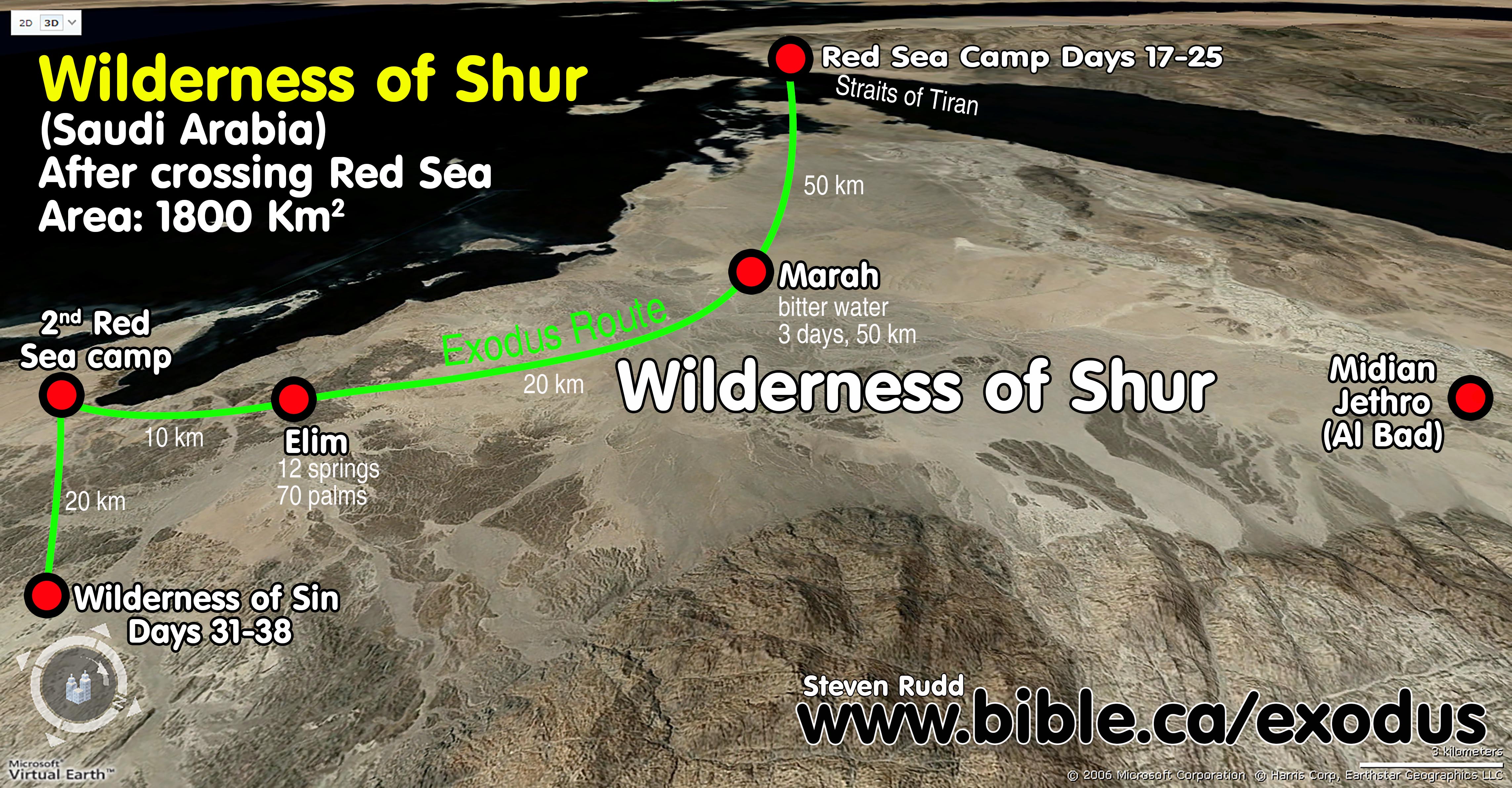
2. Marah and Elim are both in the Wilderness of Shur: "Then Moses led Israel from the Red Sea, and they went out into the wilderness of Shur Exodus 15:22
a. Since they crossed the Red Sea on a Sunday, they spent three days, Monday - Wednesday, travelling to Marah.
b. The arrival at Marah is day three from the Red Sea. Jewish time can mean a duration of Friday to Sunday being three days as we see in timing from the crucifixion to resurrection or the Trimphal entry exactly one week before that was also a Friday to Sunday duration: "Jesus said to them, "Go and tell that fox, 'Behold, I cast out demons and perform cures today and tomorrow, and the third day I reach My goal.'" Luke 13:32. So the three days could be parts of three days. Remember the Bible says they did travel day and night by the pillar of fire. So they could have left Monday night and arrived Wednesday morning.
C. Photos and maps:
|
Overview map with all the locations between the Red Sea crossing and Mt. Sinai with distances and times. |
|
|
Moses was tending his flocks not far from Midian when he saw the burning bush at Mt. Sinai. |
|
|
Marah and Elim are both in the wilderness of Shur. Distances are indicated from each stop. |
|
|
Aerial view of the wilderness of Shur and the exodus route. |
|
|
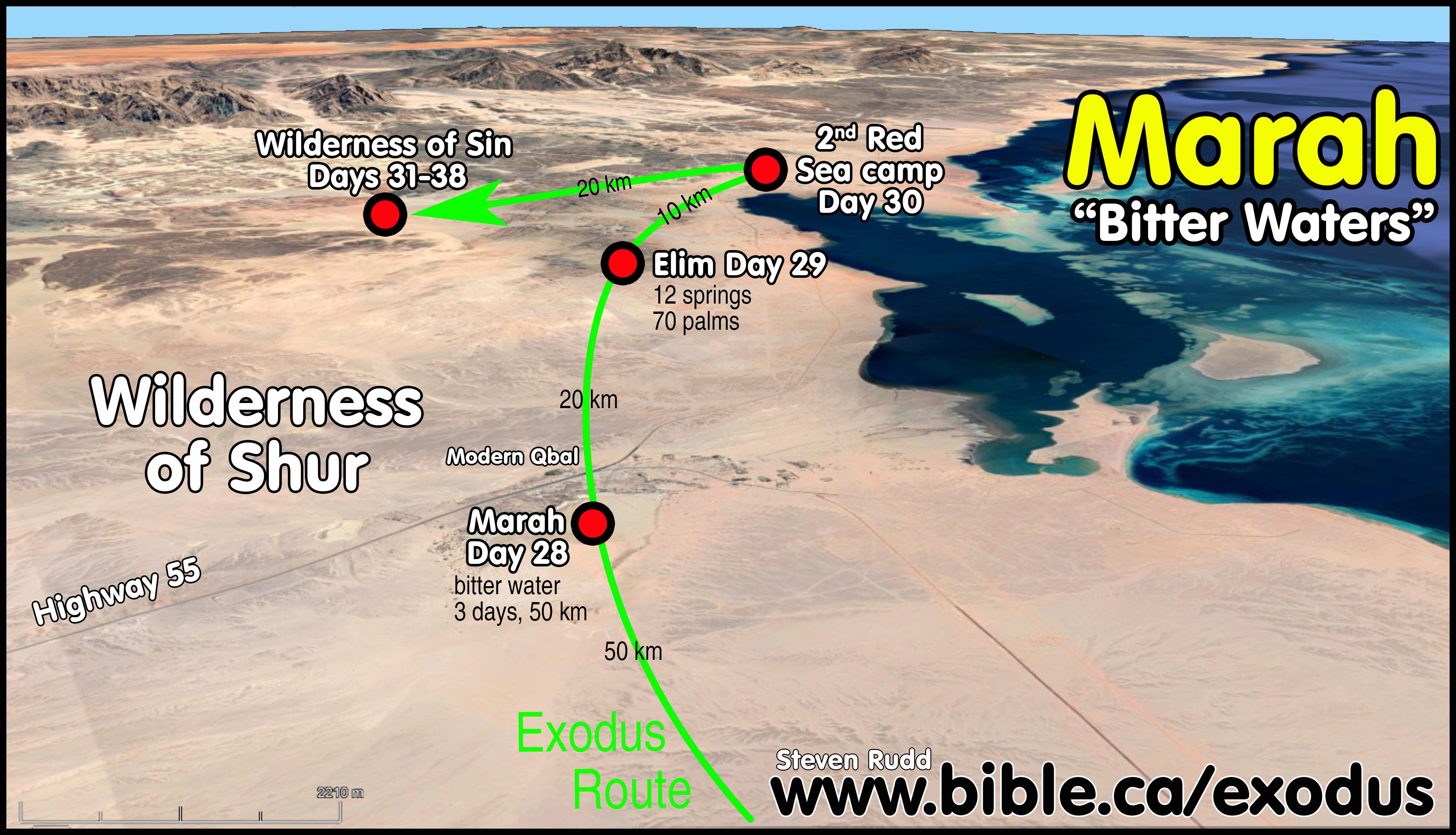
Marah close up. |
|
|
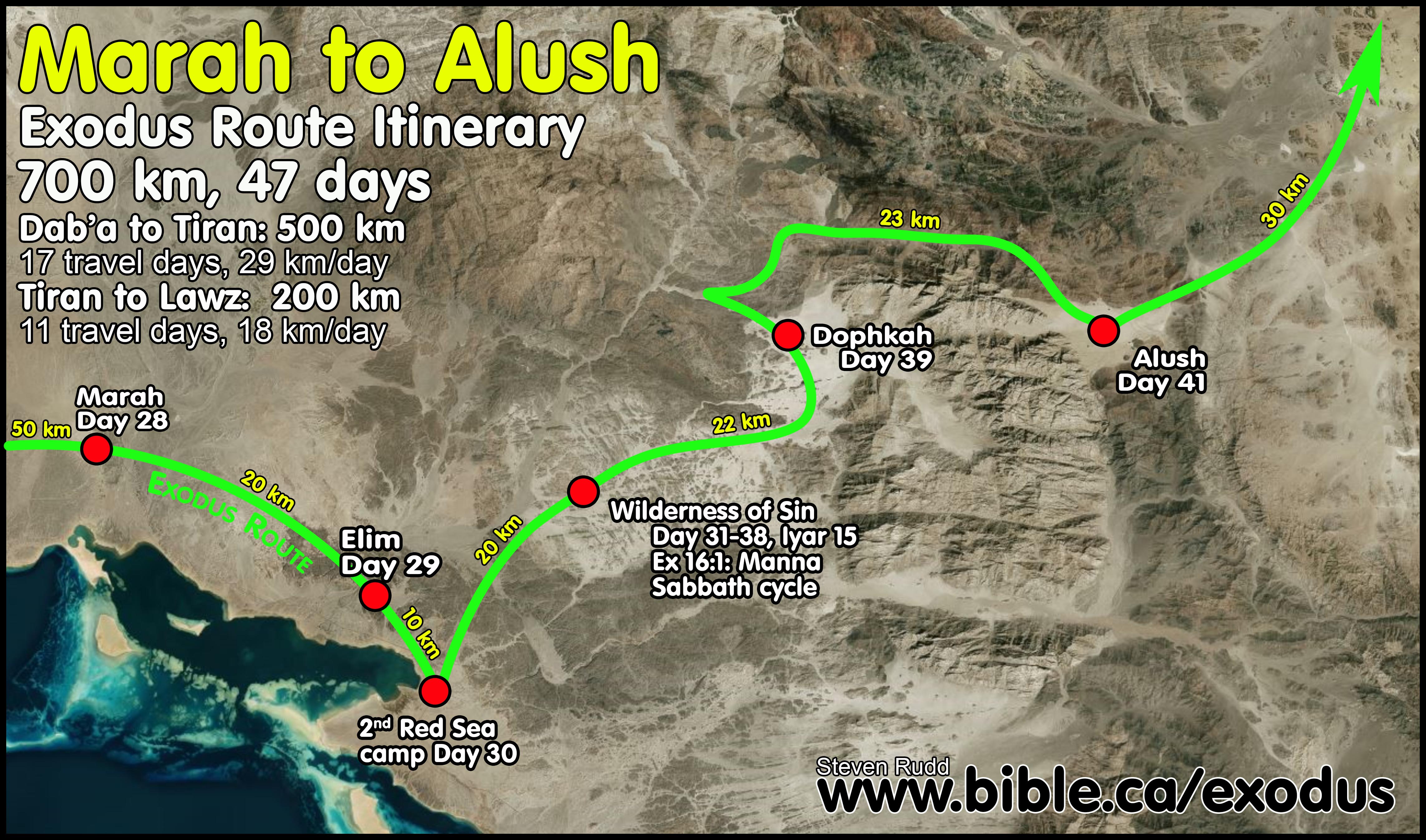
Here is the terrain looking towards the Wilderness of Sin. |
|
|
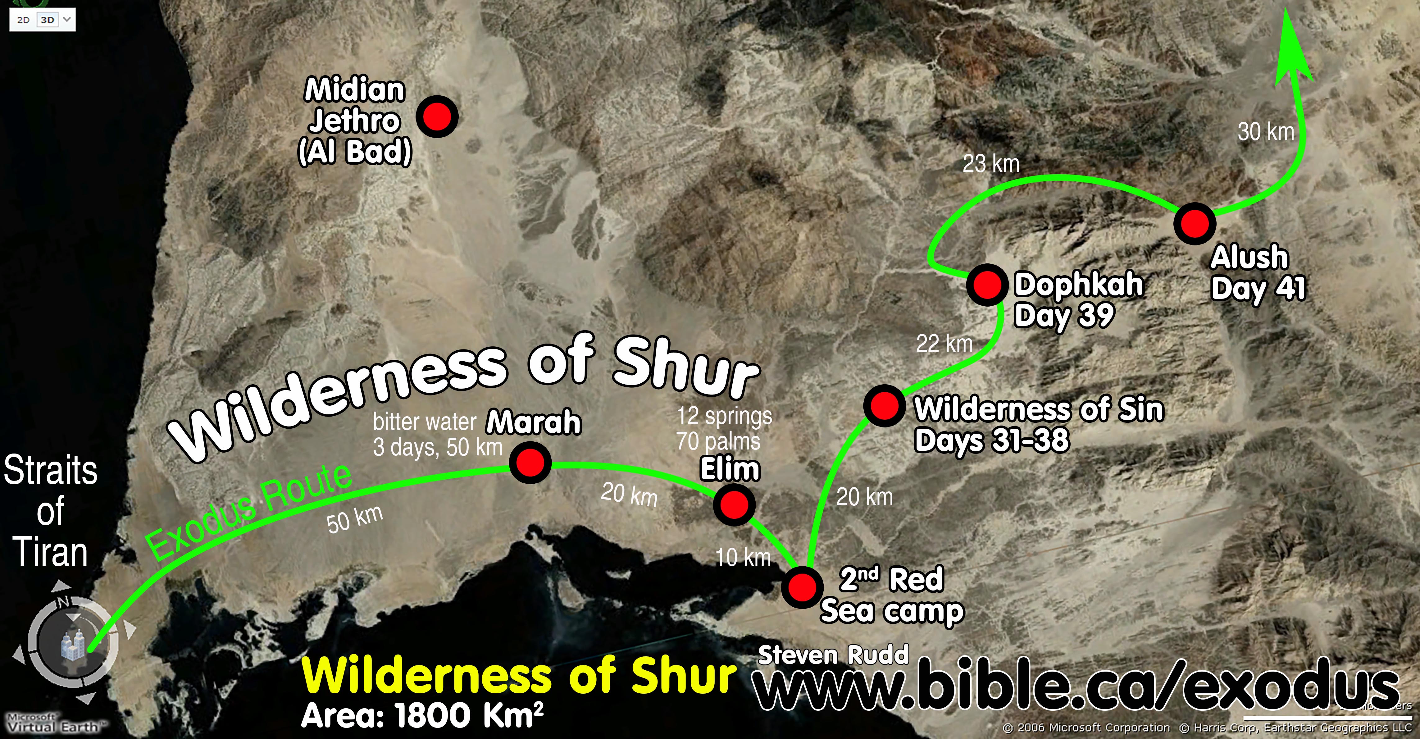
Marah to Dophkah. |
|
D. How the traditional choice for Marah fails:
- The Bible says they exited the Red Sea when to Marah and Elim, then camped beside the Red Sea again. This means that Marah and Elim were not beside the Red Sea but somewhere inland. The traditional location on most Bible maps for the Marah and Elim are on the east coastal plain of the Red Sea. The coastal flat is only about 10 km wide at this point.
- Because traditional route has Israel traveling down the east side of the Gulf of Suez in a narrow coastal plain, all three locations (Marah, Elim, second Red sea camp) are by the Red Sea. This makes no sense because Marah and Elim should not be near the Red Sea or else the narrative saying they left Elim and camped by the Red Sea is nonsense. If this was the case it would say they left the Red Sea and camped again by the Red sea at Marah, and left Marah and camped by the Red Sea again at Elim, then left Elim and camped by the Red Sea. A crossing point at the Straits of Tiran travelling 67 km straight inland, however, makes perfect sense and is logical when they change direction and stop at Elim, then head for the Red Sea and camp beside it. The traditional route doesn't work, but our route works perfect!
- The traditional route could fix this somewhat by placing Marah on the far eastern section of the coastal plain, but it still doesn't make much sense.
By Steve Rudd: Contact the author for comments, input or corrections.
