Mt.
Sinai in Arabia: The Exodus Route Restored!
Proving the
exodus route from the Bible: An Analysis of scriptural evidences.
|
VIDEO: Archeology of Mt. Sinai in Arabia (Unicorn Internet Archaeology)
Steven Rudd, 2022 Near Eastern Archaeological Society annual lectureship, Denver |
|

|
|
Exodus Route Restored:
"Don't Make the Monkey Mad!" |
Buy “Exodus Route Restored” from Amazon by Steven Rudd
Buy Discounted copy: Email Steven Rudd to order: Order discounted copy direct from author by email
|
In AD 2005, using the Bible only, Steven Rudd noticed 42 keys to decoding the Exodus Route that indicated the Red Sea crossing was at the Straits of Tiran, Mt. Sinai was in Saudi Arabia and Kadesh Barnea was at modern Petra.
ISBN: 9798619062717
As featured in Tim Mahoney’s Patterns of Evidence “The Red Sea Miracle”
|
|

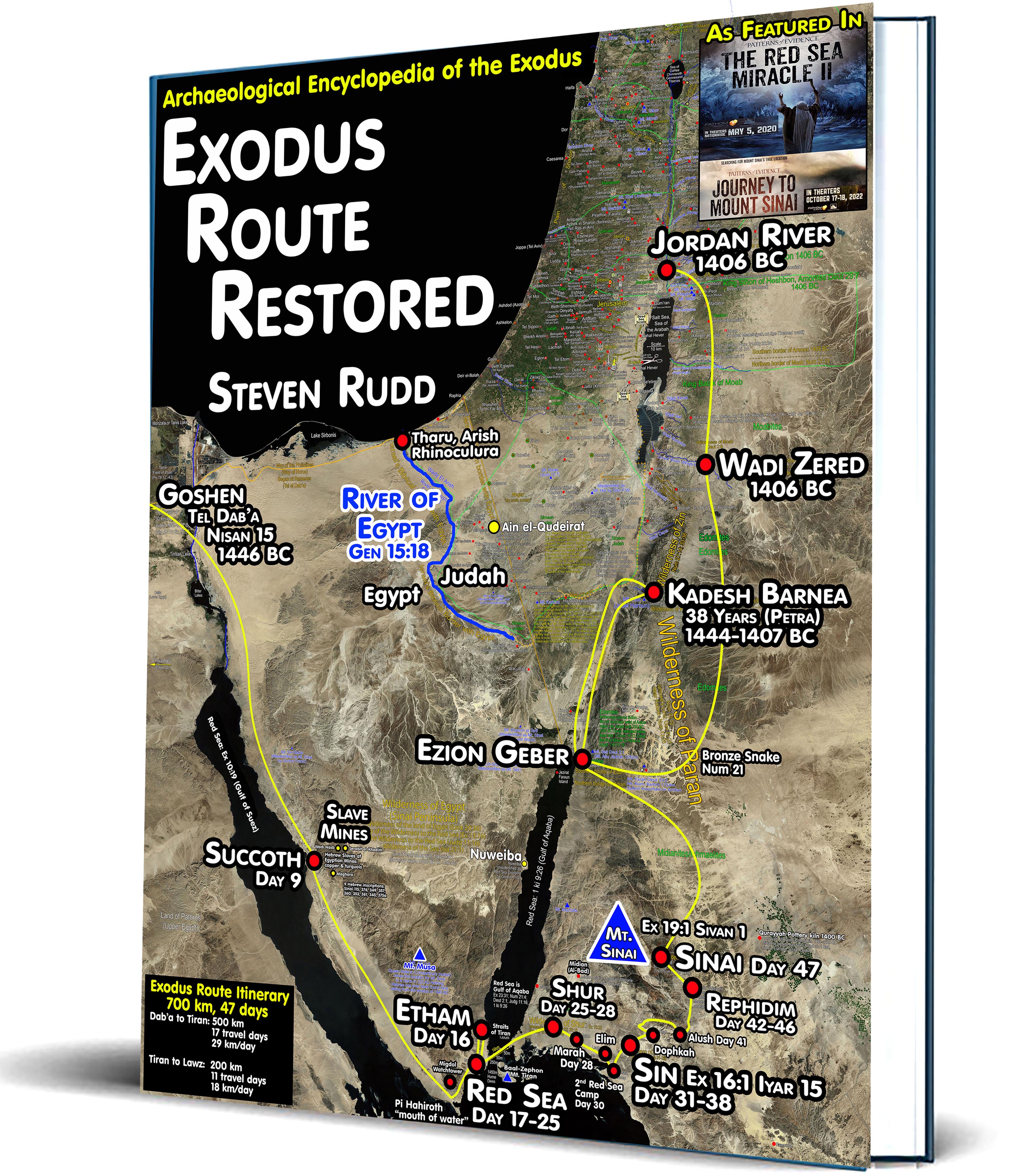
Overview of the Exodus and Conquest:
In 1446 BC, the 700 km trip from Goshen (Tell el-Dab’a) to Mt. Sinai took a total of took 47 days. After travelling day and night 500 km from Goshen, Israel made the 19 km crossing of the Red Sea at the Straits of Tiran on day 25 then took 22 days to travel 200 km from the Red Sea Crossing to Mt. Sinai. Travel was easy for the 2-3 million Hebrews because there was a 20 km wide, flat coastal plain that hugged the eastern shore of the Gulf of Suez from Goshen to the Strait of Tiran, which the author calls, “The Exodus Highway”. On day 9 after leaving Goshen, they arrived at Succoth, adjacent to the turquoise mines of Serabit el-Khadim and waited for the Hebrew mining slaves to join the main group. On day 15 they reach the Straits of Tiran and pass the Egyptian Migdol watchtower stationed above the final Red Sea crossing point and on day 16 they reached the dead-end at Etham. God orders them to backtrack to the final Red Sea crossing camp beside the Migdol where God used Israel to bait Pharaoh to attack. On day 17, as Israel leaves Etham, it would take 4 hours for a passenger pigeon (cf. Eccl 10:20) to fly 400 km from the Egyptian watchtower (Migdol) back to Egypt with the message that Israel was trapped and wandering aimlessly. (If a passenger pigeon was not used, Israel travelled day and night arriving on day 7, leaving plenty of time for a message to get back to Egypt by horseback in 7 days and pharaoh to return in 7 days, maintaining a Red Sea crossing on Day 25.) For 8 days Israel camped at the Red Sea crossing point (days 17-24) while Pharaoh's army pursued them with 600 choice horse-drawn chariots (Exodus 14:6-9). On day 18 Pharaoh's army easily traveled the 400 km from Goshen to the Red Sea crossing in 7 days (days 17-24), at a rate of 57 km/day with horse-drawn chariots and arrived on day 24. The Egyptians were stopped on the eastern shore of the Gulf of Suez by an angel, about 36 km short of Israel’s camp. After crossing the Red Sea at the Straits of Tiran via the natural underwater land bridge on day 25, Israel travelled 3 days (day 25-27) on “The Exodus Highway” through the Wilderness of Shur and the land of Midian, then travelled 3 more days (day 28-30) and arrived at the second Red Sea camp, then one more day to reach the wilderness of Sin. The only difficult portion of the trip was the canyons between the Wilderness of Sin through Dophkah to Alush. Amazingly Scripture notes that only during this portion of the journey, they “travelled in stages” (Ex 17:1) because the terrain was narrow and difficult. Exactly 31 days after leaving Goshen they enter the Wilderness of Sin (Nisan 15 - Iyar 15: Ex 16:1). In the Wilderness of Sin Israel camped 8 days (day 31-38) to learn about the Manna/Sabbath day cycle. Leaving the Wilderness of Sin as a single group of 2-3 million, Israel arrived at Dophkah on day 39. Between Dophkah and Alush Israel travelled in small groups by “stages” through the 23 kilometers of mountain canyons to Alush on days 40-41. On days 41-42 Israel arrived in stages at Rephidim and complained about having no water. God told Moses that when he finally arrived at Mt. Horeb, he is to bring water out of the “split rock” as the main water supply for the 11 months stay camped at the foot of Mt. Sinai. On the night of day 42 the Amalekites attack and the next morning Moses assembles an army, and his hands are held up high on a hilltop on day 43. That night Jethro arrives, and watches Moses judge the people all day long on day 44. Day 45 is the second sabbath and Jethro gives Moses his advice about delegating the judging duties to others. Day 46 Jethro returns home to Midian while Moses departs for Mt. Sinai arriving after dark on day 47 which is Sivan 1 (Ex 19:1). In the morning of day 47 Moses strikes and splits the rock at Mt. Horeb for a massive water supply for 3 million Hebrews. On day 48 Moses ascends Mt. Sinai for the first time and God recites the Ten Commandments orally. Moses descends and tells the people to take an oath to obey the laws of YHWH (Ex 19:3-8). On day 50 (Thursday, Sivan 4), God tells Israel to prepare for three days (Friday – Sunday) at the end of which God will descend upon Mt. Sinai. (Ex 19:10-11). On Pentecost Sunday (Sivan 7), day 53 from leaving Egypt, Mt. Sinai explodes (Heb 12:18) when God gives the law to Moses over a period of 40 days. Israel spent 343 days (11 lunar months and 19 days) camped in the Wilderness of Sinai (Num 10:11) while Moses received the law and Israel built the Tabernacle tent. The journey from Mt. Sinai through Ezion Geber (Numbers 33:35-36) to Kadesh Barnea, was 20 stops over a period of about 11 months. Israel spends 38 years camped at Kadesh Barnea located at modern Petra. Aaron died on the 1st day of the 5th month of the 40th year of the wilderness wandering (summer 1407 BC). Shortly after mourning Aaron for 30 days, the people left Mount Hor which was beside Petra (Kadesh) and moved south to the Red Sea (“Yam Suph”- Deut 1:40 – Gulf of Aqaba) passing a second time through Ezion Geber (Deut 2:8). They journeyed east to avoid the Edomites living in the mountains and began moving north. Before they crossed the Wadi Zered, Israel rebelled again with the result that God sends poisonous snakes to kill the people. In obedience to God, Moses sets up a pole with a snake to heal them. Those who had been bitten could look at the snake and be healed as a type of the crucifixion of Christ (Jn 3:14). They crossed the Wadi Zered at the south end of the Salt Sea and Moses spoke the words of the book of Deuteronomy at Iye-abarim. The conquest began and Israel passed directly through Dibon-gad and commenced the defeat of the Transjordan nations. While camped at Shittim (Tel Hammam) Israel mourned Moses for 30 days. In 1406 BC Israel crossed the Jordan on the 10th day of the 1st month of the 41st year (spring, 1406 BC), four days before the 41st Passover, which was exactly 40 years from when they left Goshen. They started counting sabbatical years and Jubilees after crossing the Jordan. (Num 33:38; 20:28; Deut 34:8; Josh 4:19; 5:10). Israel camped at Gilgal then defeated Jericho and Ai. They traveled to Shechem and built Joshua’s Altar. The Ark of the Covenant was positioned in the valley between Mt Gerizim and Mt. Ebal with half the tribes on each of the two mountain sides. The echo-ritual “curses and blessings ceremony” of Deut 27-28 were spoken across the valley to each of the six tribes on each side. From 1406-1400 BC Israel first defeated the northern Amorite Pentapolis, then second, the southern Amorite Pentapolis. They were unable to defeat the five Philistine Pentapolis cities (Ex 13:17-18; Deut 2:23; Josh 11:22; 13:2-3; Jud 1:18-19; 3:1-3) until the time of David. The Philistines had restricted Israel’s possession of the promised land to the central hill country until 1003 BC. After 6 years of conquest war, on the first Sabbatical year of 1399 BC, Israel moved the tabernacle from Gilgal to Shiloh which served as Israel’s first capital city for 305 years until the Philistines burned the city in 1094 BC.
Quick links within this document:
Links to related Exodus Route documents
10 Chronological facts about the events of the Exodus
Historical survey before the Exodus
Exodus Antitypes in the New Testament
25 antitypical parallels between Moses and Apostle Paul
14 Keys that unlock the Exodus Route:
1. The Exodus was a Miracle: They journeyed day and night
2. Succoth: The stop to get Hebrew miners at Serabit el-Khadim
3. The Etham Dilemma: "The Great Backtrack when they hit THE WALL"
4. The Ignored second Red Sea camp
5. "Journey in stages" through mountains and difficult terrain
6. Edom's territory was Transjordan from 1446 - 605 BC.
7. Moses was "not out of Egypt" until he was off the Sinai Peninsula
8. The River of Egypt is the border between Egypt and Israel
10. The southern border of Judah puts Kadesh at Petra
11. "Piltdown Kadesh" vs. Biblical Kadesh Barnea at Petra
12. Without the Gulf of Aqaba, the Sinai Peninsula becomes Arabia.
13. How Paul, Josephus, Strabo and Herodotus defined Arabia
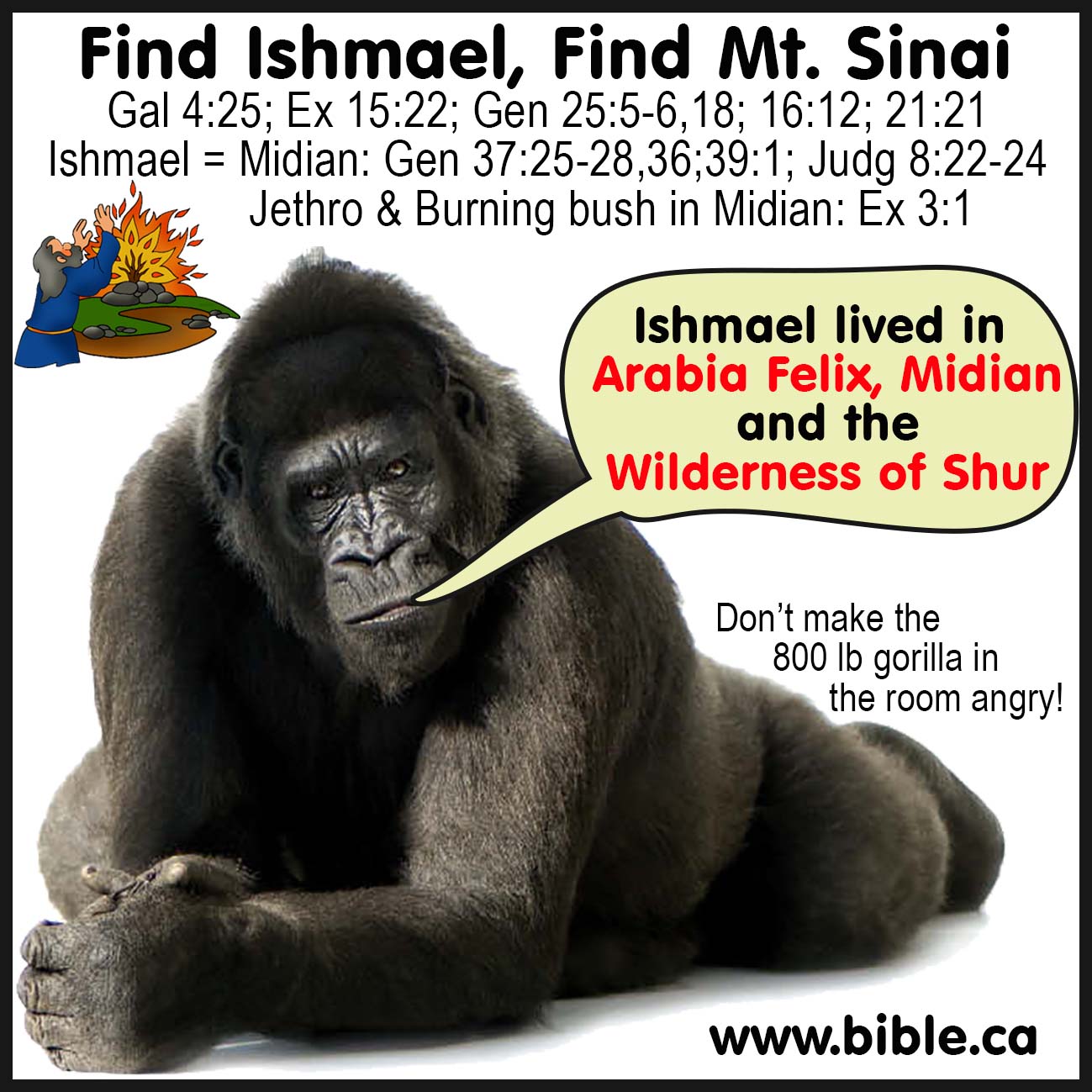
14. Ishmael Is Arabia: Find Ishmael, find Sinai! Ishmael lived in Shur.
50 stops of the Exodus: (4 legs of the Journey)
![]() 3 stops between Goshen and the Red Sea crossing
3 stops between Goshen and the Red Sea crossing
Goshen, Wilderness of
Egypt, Succoth, Migdol,
Etham, Pi Hahiroth, Baal Zephon, Straits of Tiran
![]() 10 Stops between the Sea crossing and Mt. Sinai
10 Stops between the Sea crossing and Mt. Sinai
Wilderness
of Shur, Marah, Elim, Second Red Sea Camp,
Wilderness of Sin,
Dophkah, Alush, Rephidim (Meribah),
Wilderness of
Sinai, Mt. Sinai, Wilderness of
Paran
![]() 22 Stops between Mt. Sinai and Kadesh Barnea
22 Stops between Mt. Sinai and Kadesh Barnea
Ezion Geber, southern Arabah valley, Kadesh Barnea, Petra, El-beidha
Wilderness
of Zin, Ein
el-Qudeirat, Ein
Qedeis, Ein
El Weibeh, Ein Hasb
Jezirat Faraun
Island, Timna,
![]() 15 Stops between Kadesh Barnea and the Jordan
15 Stops between Kadesh Barnea and the Jordan
Mt. Hor, Edom and Mt. Seir, The Way of the Spies and Hormah
See also:
![]() Top
ten list of reasons why the exodus route was not restored until now.
Top
ten list of reasons why the exodus route was not restored until now.
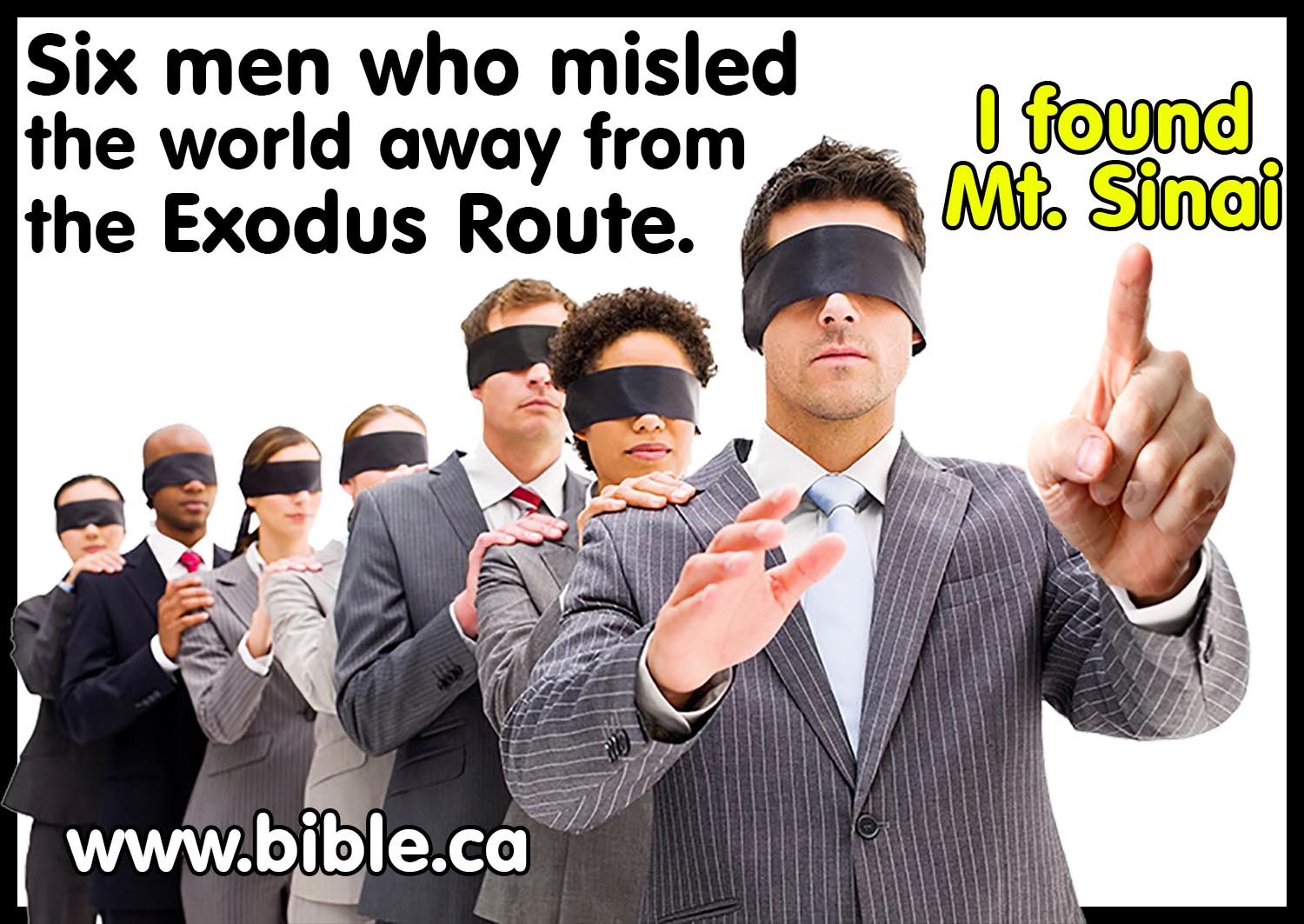
![]() Six
men who misled the world away from the true exodus route.
Six
men who misled the world away from the true exodus route.
![]() Date and Pharaoh of the Exodus:
1446 BC. Thutmoses III (1485 - 1431 BC)
Date and Pharaoh of the Exodus:
1446 BC. Thutmoses III (1485 - 1431 BC)
![]() When
was Israel "out of Egypt"?
When
was Israel "out of Egypt"?
![]() Miracles of the Exodus and
Red Sea Crossing
Miracles of the Exodus and
Red Sea Crossing
![]() The eight ascensions of
Moses up Mt. Sinai
The eight ascensions of
Moses up Mt. Sinai
![]() History of the search for Kadesh
Barnea.
History of the search for Kadesh
Barnea.
![]() Antitypes
of when Moses struck the rock.
Antitypes
of when Moses struck the rock.
![]() Thirty-eight
continuous years at Kadesh
Thirty-eight
continuous years at Kadesh
![]() Judah's
southern border and the location of Kadesh.
Judah's
southern border and the location of Kadesh.
![]() Travel
times, distances, days of the week
Travel
times, distances, days of the week
![]() History of the
Transjordan Territory of the Edomites.
History of the
Transjordan Territory of the Edomites.
![]() Historic
antique Exodus route maps from 1500 AD that had no Gulf of Aqaba.
Historic
antique Exodus route maps from 1500 AD that had no Gulf of Aqaba.
![]() Population
of the Exodus Jews: 2-4 Million Hebrews left Egypt not 35,000!
Population
of the Exodus Jews: 2-4 Million Hebrews left Egypt not 35,000!
![]() Excluding
various exodus routes: We reject: Bitter lakes, Lake Sirbonis, Lake Ballah,
Nuweiba Beach, Gulf of Suez, Mt. Musa, Ein el-Qudeirat, Mt. Karkom, Gebel Khashm et-Tarif (Hashem
el-Tarif), Mt. Sin Bisher.
Excluding
various exodus routes: We reject: Bitter lakes, Lake Sirbonis, Lake Ballah,
Nuweiba Beach, Gulf of Suez, Mt. Musa, Ein el-Qudeirat, Mt. Karkom, Gebel Khashm et-Tarif (Hashem
el-Tarif), Mt. Sin Bisher.
10 Quick Chronological facts:
1. The Date of the Exodus: 1446 BC
2. Pharaoh who killed Hebrew children: Amunhotep I: 1532-1511 BC
3. Pharaoh's Daughter who adopted Moses: Hatshepsut: 1526 BC
4. Pharaoh of Moses' flight to Midian in 1486 BC: Thutmoses II/Hatshepsut: 1498-1485 BC
5. Pharaoh of the Exodus: Thutmoses III: 1485/1464 - 1431 BC
6. Red sea crossing: Straits of Tiran on the gulf of Aqaba crossing on day 25 arriving 20 days later at Mt. Sinai on day 44.
7. Mt. Sinai: Jebel/Mt. Lawz in Saudi Arabia arriving on day 47 and spending 11 months, 5 days at Sinai.
8. Kadesh Barnea at El Beidha beside modern Petra spending 38 years.
9. Crossing the Jordan in 1406 BC, 40 years to the exact day they left Egypt.
10. The Conquest took 6 years and on the first sabbatical year of 1399 BC they set up the
tabernacle tent at Shiloh where it stood for 305 years until 1094BC.

Authors note: The exodus route proposed herein was conceived by the author in 2005 AD, but it is actually a restoration of the ancient view held by first century Christians.
1. Step #1: I began with the Bible as my only guide and blueprint for locating places connected with the exodus. I completely ignored everything EXCEPT the bible: I ignored maps, history, commentaries and the opinions of my fellow archeologists. From this study, I concluded the Scriptures taught that Israel crossed the Red Sea somewhere on the Gulf of Aqaba, forcing Mt. Sinai to be in Saudi Arabia. (Paul plainly tells us Mt. Sinai is in Arabia: Gal 4:25) I was also able to prove from scripture that Kadesh Barnea must be Transjordan, somewhere south of the Dead Sea in modern Jordan.
2. Step #2: Only after I had concluded my scriptural study, did I begin to consider two important additional witnesses: Historical literary sources and archaeology. Josephus, Eusebius Jerome and others pointed Mt. Lawz as the best candidate for Mt. Sinai. Josephus and Eusebius led me to target the general Petra area for the location of Kadesh Barnea. When conflicts arose between the Scriptures, history and Archaeology, I always chose the infallible, all-sufficient, imperishable and inerrant Word of God.
While this may not make Bible doubting archeologists happy, I have more trust in the Bible than the ever-shifting opinions of fellow archeologists who are often looking to disprove the Bible, rather than support it as the book of true ancient history that it really is. Having said this, Archaeology is an important tool in validating the Bible. I have travelled extensively throughout Israel and the Levant. I have been directly involved in many archeological digs under the authority of the IAA (Israel Antiquities Authority). I am a professional staff archeologist for the Shiloh Israel excavation from 2017 to the present. I did not discover this exodus route, I merely restored it to what is revealed in scripture. I hope this book will strengthen your faith in God's inspired word. You can print the maps and glue them into the back of your bible. You can use this material in public presentations and sermons, as long as you do not put any part of this book on the internet or sell it.
![]() Why not visit one of our local churches? Click here to
locate a congregation in your hometown.
Why not visit one of our local churches? Click here to
locate a congregation in your hometown.
Steve Rudd: Contact the author for comments, input or corrections.
|
The Exodus Route |
|
|
|
|
|
|
|
|
|
|

Introduction: Historical and Archaeological survey of the Exodus
1899 BC: Israelites enter Egypt
The Hebrews entered Egypt in 1899 BC when Joseph was sold by his brothers to the Ancient Arabians known as "Ishmaelites". Archeology has shown from excavations at Ramesses (Avaris, Goshen, Tel el-Dab'a), that at the time of Jacob entering Egypt in 1876 BC, Asiatics (i.e. Semitics) ran a commerce hub located there as an egalitarian society. In 1997 AD, agnostic David Rohl was first to make the connection with the archeology at Tel el-Dab’a and the tomb of Joseph. Rohl reexamined the excavation reports by Austrian Manfred Bietak, who was director at Tel el-Dab'a. For this Rohl is to be praised in spite of the fact that he unnecessarily shifts Egyptian Chronology hundreds of years. From ancient times, Goshen (Tel el-Dab'a) was the main shipping commercial hub at the beginning of the “Way of Horus” coastal road north to Tyre. The Hebrews were very prosperous until the Hyksos arrived and took over the management of Avaris. Like modern port cities with millions of containers being loaded and offloaded from ocean tanker ships, Avaris needed huge storage areas for all the goods.
|
|
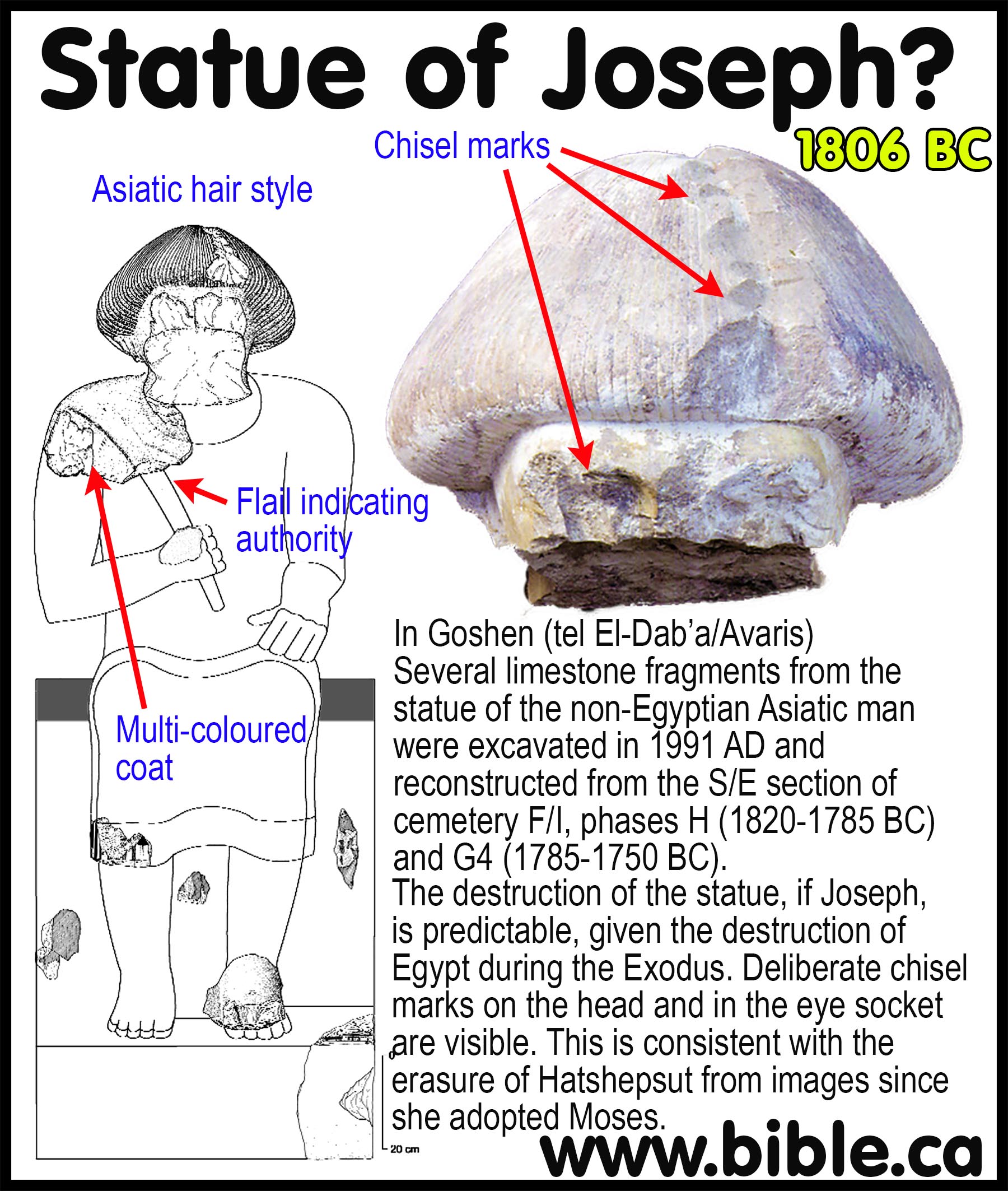
A stunning archeological find at Tel el-Dab'a was a fractured statue that dated to the 12th Dynasty Pharaohs (c. 1806 BC). In Goshen (tel El-Dab’a/Avaris) several limestone fragments from the statue of the non-Egyptian Asiatic man were excavated in 1991 AD and reconstructed from the S/E section of cemetery F/I, phases H (1820-1785 BC, Low Egyptian Chronology = LC) and G4 (1785-1750 BC, LC). These dates correspond to the death of Joseph in 1806 BC. The Egyptians were always careful to portray different things that showed the national background of the subjects of their paintings or statues, as well as their status in society. The person portrayed in this statue had a lighter skin than was used in portraying native Egyptians. He also had a flail held across his chest. The flail symbolized that a person possessed considerable authority, but not a pharaoh. Pharaohs were shown with the double crown of Egypt and the ‘uraeus’ or cobra’s head on that crown. He was therefore an ‘Asiatic’, Semitic person (Hebrew). Single and double donkey burials excavated at the tomb complex are typical of Semitic ritual at the time of Joseph and indicate Hebrews were present. |
Low Egyptian Chronology (LC) is favored. Kris J. Udd notes that the trend is towards the Low Chronology of the 18th dynasty Egypt which makes Thutmoses III the pharaoh of the Exodus because LC start of his reign was 1485 BC. (Has Radiocarbon Artificially Raised Bronze Age Dates?, Near Eastern Archaeological Society Bulletin, Vol 58, 2013 AD)
The mushroom hairstyle is also Semitic and non-Egyptian. An additional fragment from the shoulder with the flail features a clear multi-coloured coat design. The coat Jacob gave Joseph got him sold to Egypt but then became the symbol of his authority over them. His statue had been smashed into pieces by someone who was very angry at him and what he represented, although previously he must have been held in high regard. The destruction of the statue, if Joseph, is predictable, given the destruction of Egypt during the Exodus. Deliberate chisel marks on the head and in the eye socket are visible. This is consistent with a widespread phenomenon known as the “erasure of Hatshepsut” (see below) at the time of the Exodus, where many of the images of her that had been carved in wall reliefs were deliberately defaced with chisel marks, likely because since she adopted Moses who destroyed Egypt with 10 plagues. The statue of Joseph was slightly larger than life size. It was also associated by some archaeologists with an impressive mansion that its own tomb in the form of a small pyramid. The tomb, however, was empty; someone had removed the mummy, apparently before the smashing took place. This led to speculation that this was a portrayal of Joseph, since all these facts would fit what we know about Joseph from the Bible. It has therefore been called by some “the Joseph statue.” Others think it is instead a statue of Joseph’s father, Jacob, but this does not fit with the youthful appearance; Joseph was 30 years old when he became vizier, but Jacob did not enter Egypt until he was 130 (Genesis 47:9).
1657-1538 BC: Hyksos rule Egypt for 119 years: “The Pharaohs who knew Joseph”.
In c. 1657 BC the Hyksos overthrew the pharaohs of Egypt and built their palaces at Tel el-Dab'a. The Hyksos ruled for about 119 years, displacing the Egyptians as the government of Egypt. They were the Pharaohs who "knew Joseph" and cooperated with the Hebrews. Archeology has confirmed that the Hyksos built three palaces at Tel el-Dab'a directly beside the Hebrews. From the time of Joseph down to the end of the Hyksos period, the Hebrews enjoyed freedom with no slavery, but that was about to end. The Hyksos were expelled by the 18th dynasty Pharaohs of Egypt who “Knew not Joseph”. In 1538 BC Ahmoses I finally defeated the Hyksos and the Hebrews were stripped of their financial control of the commercial shipping hub and became oppressed slaves who built two storage cities of Pithom and Ramesses (Ex 1:11). The oppression of the Hebrews began in 1538 BC and ended in 1446 BC with the Exodus of Moses.
Egyptian oppression and slavery began in 1538 BC
1557 BC: Rise of the 18th Dynasty "MOSES PHARAOHS who knew not Joseph"
Ahmoses I (1557-1532 BC) was only 10 years old when he ascended the throne after the death of his brother. Excavations at Tel el Dab’a (Avaris) by Bietak and synchronisms with day book entry in year 11 of Khamudi (the last Hyksos king) in the Rhind Mathematical Papyrus indicate the defeat of the Hyksos at Avaris started in the 15th year of Ahmoses I in 1542 BC. This seems to be confirmed by records of Ahmoses I first military campaigns which began after his 10th regnal year in 1547 BC at age 20. Inscriptions on the wall of a cliff-tomb at El Kab, located 100 km south of Luxor, of a naval officer named Ahmoses (who served under three pharaohs: Ahmoses I, Amenhotep I, and Thutmose I,) contains the biography of Ahmoses I. The El Kab inscription records a sequence of three successive sieges of Avaris that were interrupted by a Nubian offensive which was defeated. Avaris finally fell after the 4th attack. Khamudi, the defeated Hyksos king then fled from Avaris to the biblical city of Sharuhen (Joshua 19:6) in the Simeon Negev where the inscription records a six-year siege until Sharuhen finally fell in the 21st regnal year (1536 BC). This marks the end and final expulsion of the Hyksos by Ahmoses I. The inscription then records the first foreign offensive campaign south into Nubia against the Troglodytes and two successive counter attacks that were defeated. Another inscription found in the ancient Egyptian mining town of Tura located 15 km south of Cairo on the east bank of the Nile, indicate the latest possible date for the defeat of the Hyksos was in the 22nd regnal year of Ahmoses I (1535 BC). “Ahmoses must have conquered Avaris by [sometime before] the 18th or 19th year of his reign. This is suggested by a graffito in the quarry at Tura whereby, “oxen from Canaan were used at the opening of the quarry” in Ahmoses’s regnal year 22. Since the cattle would probably have been imported after Ahmoses’s siege of the town of Sharuhen, which followed the fall of Avaris, this means that the reign of Khamudi must have terminated by year 18 or 19 (1539-1538 BC) of Ahmoses’ 25-year reign (1557-1532 BC) at the very latest.” (Egypt, Canaan, and Israel in Ancient Times, Redford, Donald, Bronze Age Collapse, Ch 8, 1992 AD) We conclude that the Hyksos ruled Egypt for no earlier than 1657 BC and no later than 1538 BC for a maximum total possible years of 119.
The Egyptians finally over-threw the rebel Hyksos government in 1538 BC by AhMOSES I who became the first 18th dynasty Pharaoh who "did not know Joseph" (Ex 1:8). With the rebel Hyksos expelled, Ahmoses I took over the Hyksos palaces at Tel el-Daba, which explains how Moses was found in the river by Pharaoh's Daughter near where the Hebrews lived. Ahmose I marks the beginning of the period of slavery and oppression for the Hebrews as a way to prevent the Hebrews from seeking the throne or leaving Egypt. Exodus 1:11 tells us that the Hebrews were making mud bricks to build the storage cities of Pithom (Tell el-Retaba) and Ramesses (Tel el-Dab'a), both of which have been extensively excavated through archeological digs. It may be a puzzle as to why Pharaoh would build a storage city in the very town where the Hebrews lived, until you remember that this was the main shipping hub at the beginning of the Way of Horus. (see exodus route map above) Tel el-Dab'a was a city similar to modern port cities with millions of containers being loaded and offloaded from ocean tanker ships. The Slavery and oppression was a political and social policy to make sure the Egyptians never lost economic control of their country again, as they had dating back to the time of Joseph in c 1800 BC. The specific fear of Ahmoses I was that the Hebrews would leave Egypt not that he would be deposed by them. "Come, let us deal wisely with them, or else they will multiply and in the event of war, they will also join themselves to those who hate us, and fight against us and depart from the land.” (Exodus 1:10) Notice the Exodus narrative begins with the defeat of the rebel Hyksos at the rise of Ahmose I with a special note regarding how prosperous the Hebrews had become. But during the next 92 years (1538 – 1446 BC) from Ahmose I to Thutmoses III (Pharaoh of the Exodus), the Hebrews went from a management role to slaves and may have lost some of their business skills during this period. However, God saw fit to once again give them world-class training at another major commerce center like Tel el-Dab'a at Kadesh Barnea. Kadesh, located at modern Petra, was a triple crossroads of trade where they spent 38 years once again learning trade, commerce and how to run a business. Kadesh Barnea would later become the capital city of the Nabatean Arabic empire that controlled trade routes. This may explain why even today, the Jews are so incredibly prosperous in the world of business. If only we could get these "natural branches" to believe that Jesus Christ is their risen messiah.
18th Dynasty Pharaohs of the
Exodus (LC):
Pharaoh who killed Hebrew children: Amunhotep
I: 1532-1511 BC
Pharaoh's Daughter who adopted Moses: Hatshepsut: 1526 BC
Pharaoh of Moses' flight to Midian: Thutmoses II/Hatshepsut: 1498-1485 BC
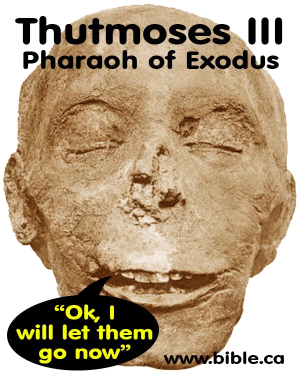
Pharaoh of the Exodus: Thutmoses III: 1485/1464 - 1431 BC. Thutmoses III
was Pharaoh in 1446 BC for a total of 54 years but there were three
distinct phases to his rule.
- (1485-1464) First was when he was a baby and his step-mother Hatshepsut ruled as co-regent for 21 years .
- (1464-1446) Second, after Hatshepsut died he ruled as Pharaoh for 18 years until the exodus .
- (1446-1431) Third, he ruled another 15 years after the exodus.
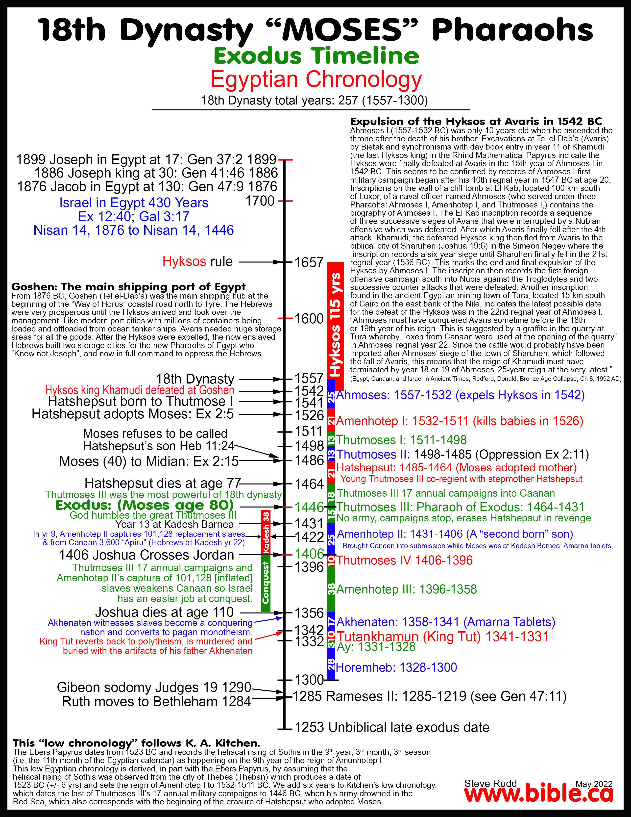
1526 BC: Moses is adopted by Hatshepsut into Pharaoh's house.
Pharaoh who killed
Hebrew children: Amunhotep I: 1532-1511 BC
Pharaoh's Daughter who adopted Moses: Hatshepsut:
1526 BC
|
The previous efforts to "let us deal wisely" with the Hebrews was not working and the Egyptians were being out-populated by the productive Israelites. Amunhotep I (1532-1511 BC, LC) decides to kill all the male Hebrew children. This is antitypical to Herod's slaughter of the babies in 1 BC after Jesus was born in 2 BC. Hatshepsut was the daughter of pharaoh who drew Moses out of the water and adopted him into the king's household. Hatshepsut was the daughter of Thutmoses I who married her brother Thutmoses II and was co-regent with her son Thutmoses III. |
|
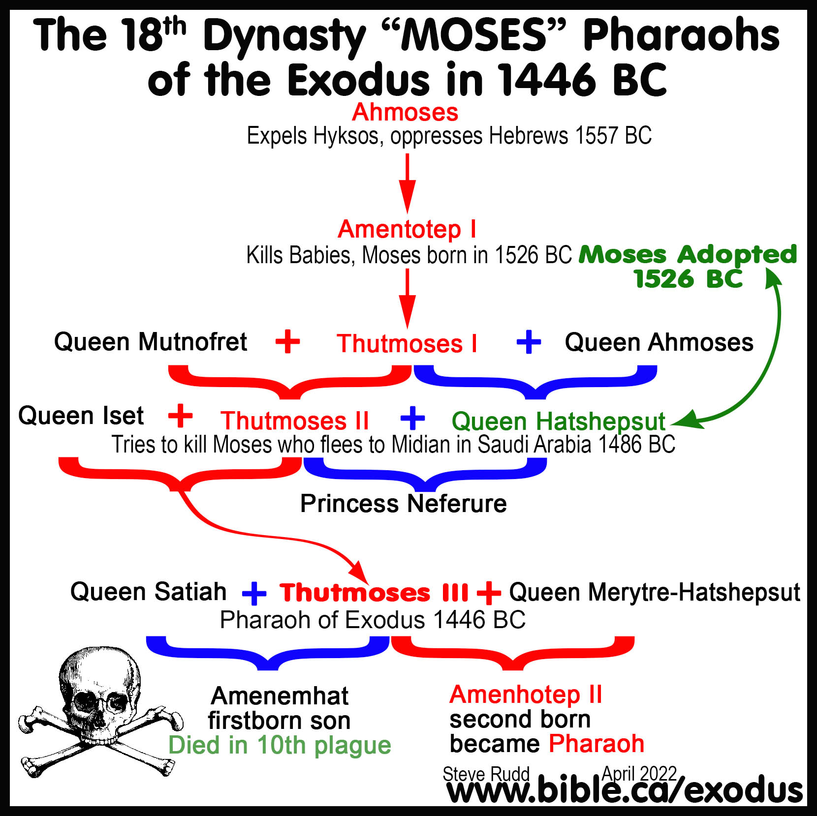
1486 BC: Moses flees to Midian in Saudi Arabia after killing the Egyptian at age 40:
Pharaoh of Moses' flight to Midian: Thutmoses II/Hatshepsut: 1498-1485 BC
Pharaoh Thutmoses II (1498-1485 BC) married his sister Hatshepsut who was the adoptive mother of Moses. Moses saw the oppression of his fellow Hebrews and killed the Egyptian, which was an act of treason. "By faith Moses, when he had grown up, refused to be called the son of Pharaoh’s daughter, choosing rather to endure ill-treatment with the people of God than to enjoy the passing pleasures of sin, considering the reproach of Christ greater riches than the treasures of Egypt; for he was looking to the reward. By faith he left Egypt, not fearing the wrath of the king; for he endured, as seeing Him who is unseen." (Hebrews 11:24–27) At age 40, Moses fled Egypt to Midian where Jethro was the priest of Mt. Sinai, which was called the "Mountain of God". Moses probably escaped exactly the same route in 1486 BC as he used 40 years later in the Exodus by travelling down the eastern shore of the Gulf of Aqaba to cross over to Arabia (Midian, wilderness of Shur) by one of the many boats that ferried between the two shores of Arabia and Egypt at the Straits of Tiran.
1446 BC: The Exodus begins after the 10 plagues destroy Egypt
Pharaoh of the Exodus: Thutmoses III: 1485/1464 - 1431 BC.
The exodus began when the entire population of 2-4 million Jews left Egypt. Be warned, that attempting to reduce the migration to 35,000 using a fallacious argument based on the Hebrew word for 1000 [elep] meaning "clans", guts the inspiration of the bible. At the time of the exodus, the city of Tel el-Dab'a was called, Parunefer meaning "happy journey" because Tel el-Dab'a is the starting and staging hub of the Way of Horus and was a major commerce center. Moses was forbidden from taking the "Way of Horus" which hugged the Mediterranean coast to Canaan. Instead, Moses retraced the possible route he took 40 years earlier, except this time he crossed the Red sea, not in a boat, but by a miracle of God. Moses arrived at Mt. Sinai and climbed the mountain for a total of eight ascensions up Mt. Sinai. The exodus Route has about 50 stops and traverses 7 wildernesses. We can be certain of only the locations of Goshen (tel El-Dab'a), Ezion-Geber, Dibon, Mt. Nebo and Shittim (Tel el-Hamman) and the wilderness of Shur (Midian) in north Saudi Arabia.
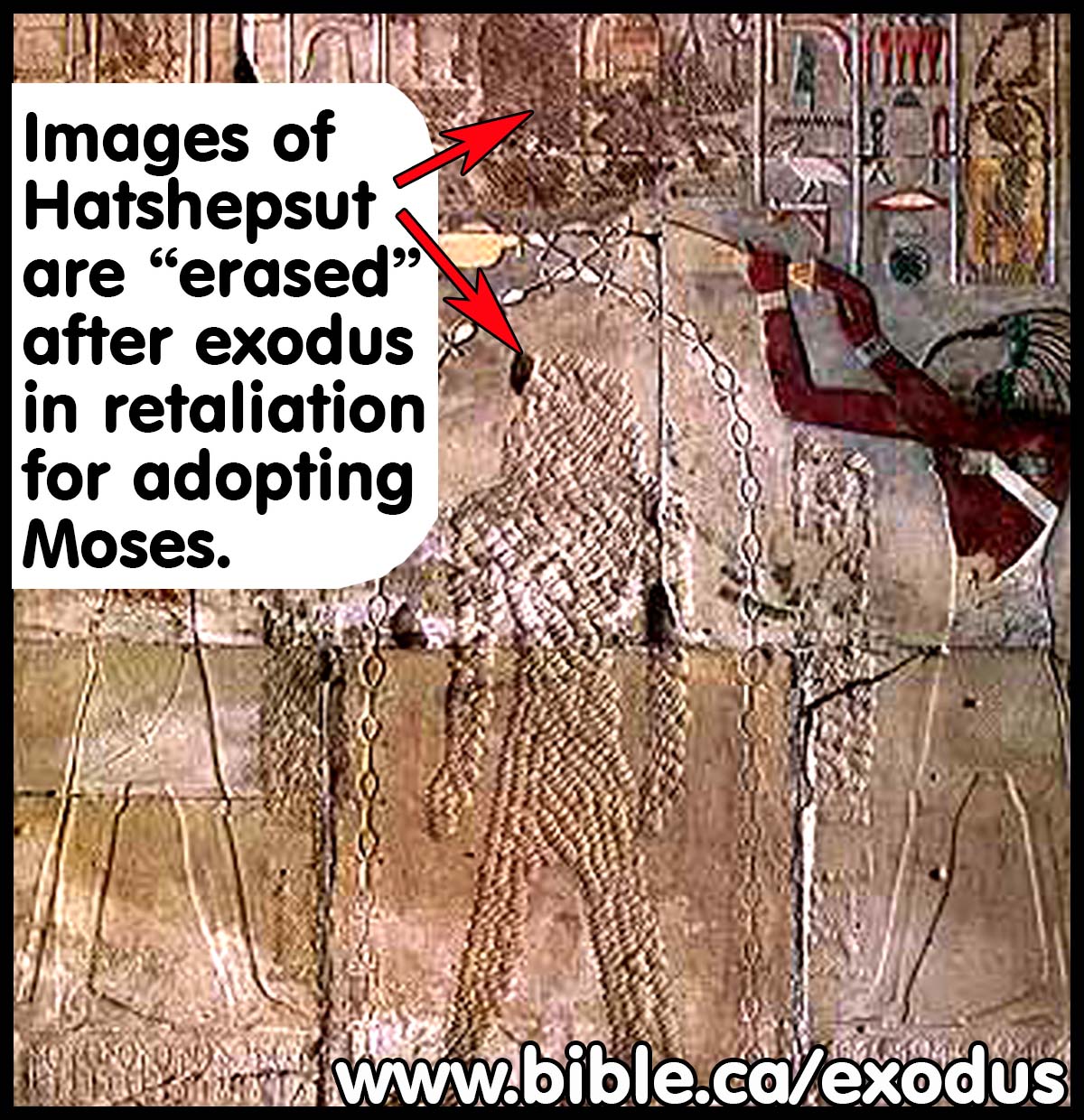
Erasure of Hatshepsut, step-mother of Thutmoses III and adopted mother of Moses
Moses and Thutmoses III were step-brothers. Hatshepsut was married to her brother Thutmoses II and when he died, her stepson Thutmoses III took the throne. Hatshepsut was coregent with her stepson Thutmoses III from 1485-1464 for a period of 21 years until she died at age 77. Thutmoses III carried out 17 annual campaigns that came to an end in 1446 BC, the year his army drowned in the Red Sea. After Egypt was destroyed by Moses, Thutmoses III began a campaign of vandalizing any images he could find of his step-mother Hatshepsut. Pharaoh himself did not die in the Red sea. Ps 136:45 says, "God overthrew [lit: shook off] Pharaoh and his army in the Red Sea."
|
|
This is referred to as the "Erasure of Hatshepsut". Thutmoses III is the best candidate as the Pharaoh of the Exodus not only because he was Pharaoh in 1446 BC, but also because an incredible double marker stands out like a flashing neon light. Two key events happened at the same time: After 17 yearly military campaigns, they suddenly stopped and at the same time the erasing of Hatshepsut from many statues and reliefs began. Both of these events happened as a direct result of the 10 plagues and the exodus of Moses. While the exact timing of the Erasure of Hatshepsut is difficult to pinpoint, the motive of vengeful retaliation for adopting Moses seems clear. |
The Exodus as a Messianic Prophecy:
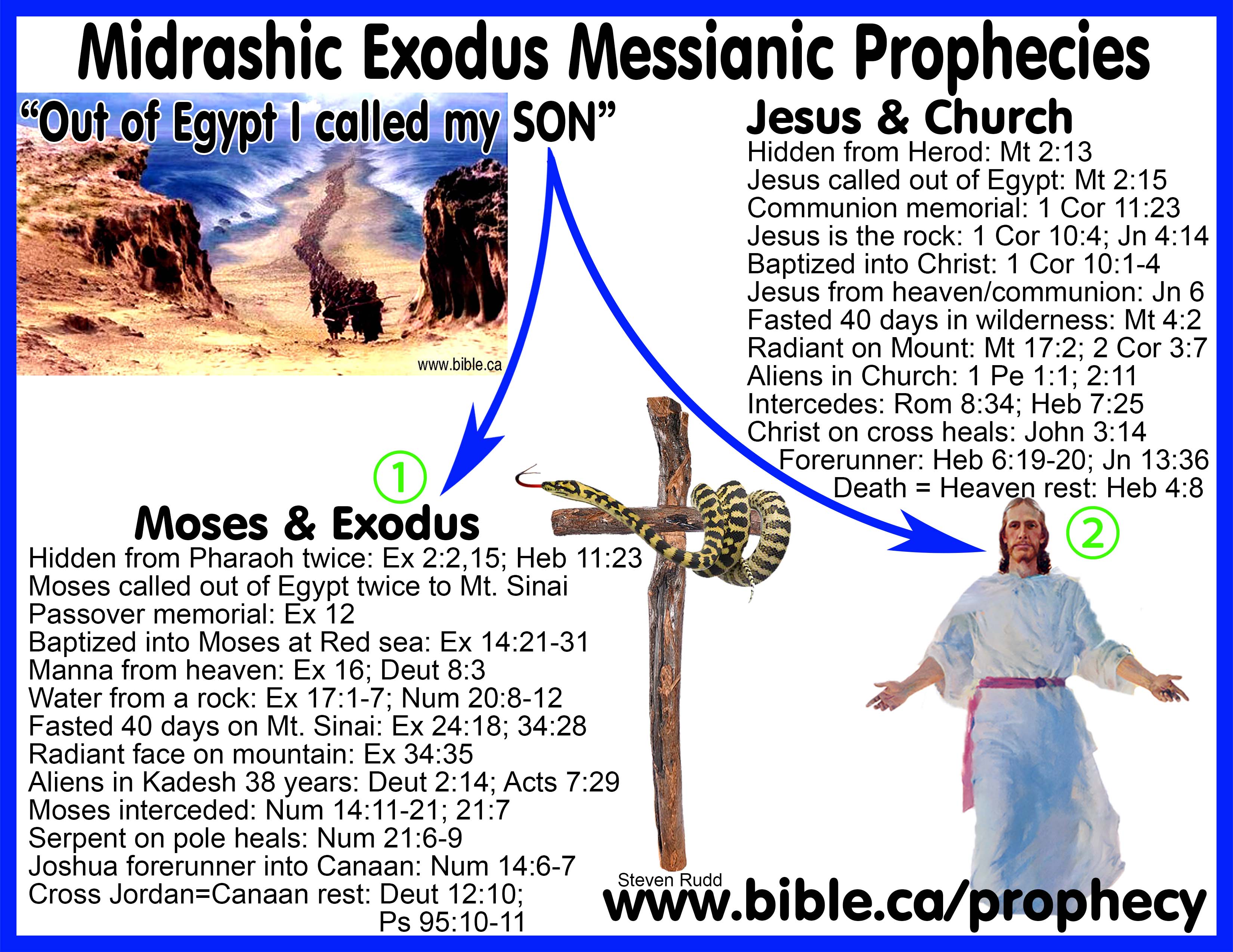
Messianic prophecies of Exodus:
|
The Exodus Story as a Messianic Prophecy “Out of Egypt did I call My Son” Mt 2:15 |
|
|
Moses and Israel |
Jesus and Church |
|
Hidden from Pharaoh twice after two death threats: Ex 2:2,15; Heb 11:23 |
Hidden from Herod: Mt 2:13 |
|
Moses called out of Egypt twice to Mt. Sinai |
Jesus called out of Egypt: Mt 2:15 |
|
Passover memorial: Ex 12:3-6 |
Communion memorial: 1 Cor 11:23 |
|
Baptized into Moses at Red sea: Ex 14:21-31 |
Baptized into Christ: 1 Cor 10:1-4 |
|
Grumbled, Manna from heaven: Ex 16; Deut 8:3 |
Grumbled, Jesus from heaven; communion: Jn 6:31-35 |
|
Jesus is the rock and waters of eternal life: 1 Cor 10:4; Jn 4:14 |
|
|
Fasted 40 days on Mt. Sinai: Ex 24:18; 34:28 |
Fasted 40 days in wilderness: Mt 4:2 |
|
Radiant face on mountain: Ex 34:35 |
Radiant on Mount: Mt 17:2; 2 Cor 3:7-8 |
|
Aliens in Kadesh 38 years: Deut 2:14; Acts 7:29 |
Aliens in Church till death: 1 Peter 1:1; 2:11 |
|
Moses Interceded: Num 14:11-21; 21:7 |
Jesus Intercedes: Rom 8:34; Heb 7:25 |
|
Serpent on pole heals: Num 21:6-9 |
Christ, a type of the serpent, on cross heals: John 3:14-16 |
|
Joshua was a forerunner when he spied out the land and who brought Israel into Canaan 40 years later: Num 14:6-7 |
Jesus was a forerunner for us into heaven at His ascension and will return to take us to heaven at the Second coming: Heb 6:19-20; Jn 13:36 |
|
Cross Jordan = Canaan rest: Deut 12:10-11; Ps 95:10-11 |
Death = Heaven rest: Heb 4:8-11 |
Many of the New Testament antitypes and images have their origin in the exodus.
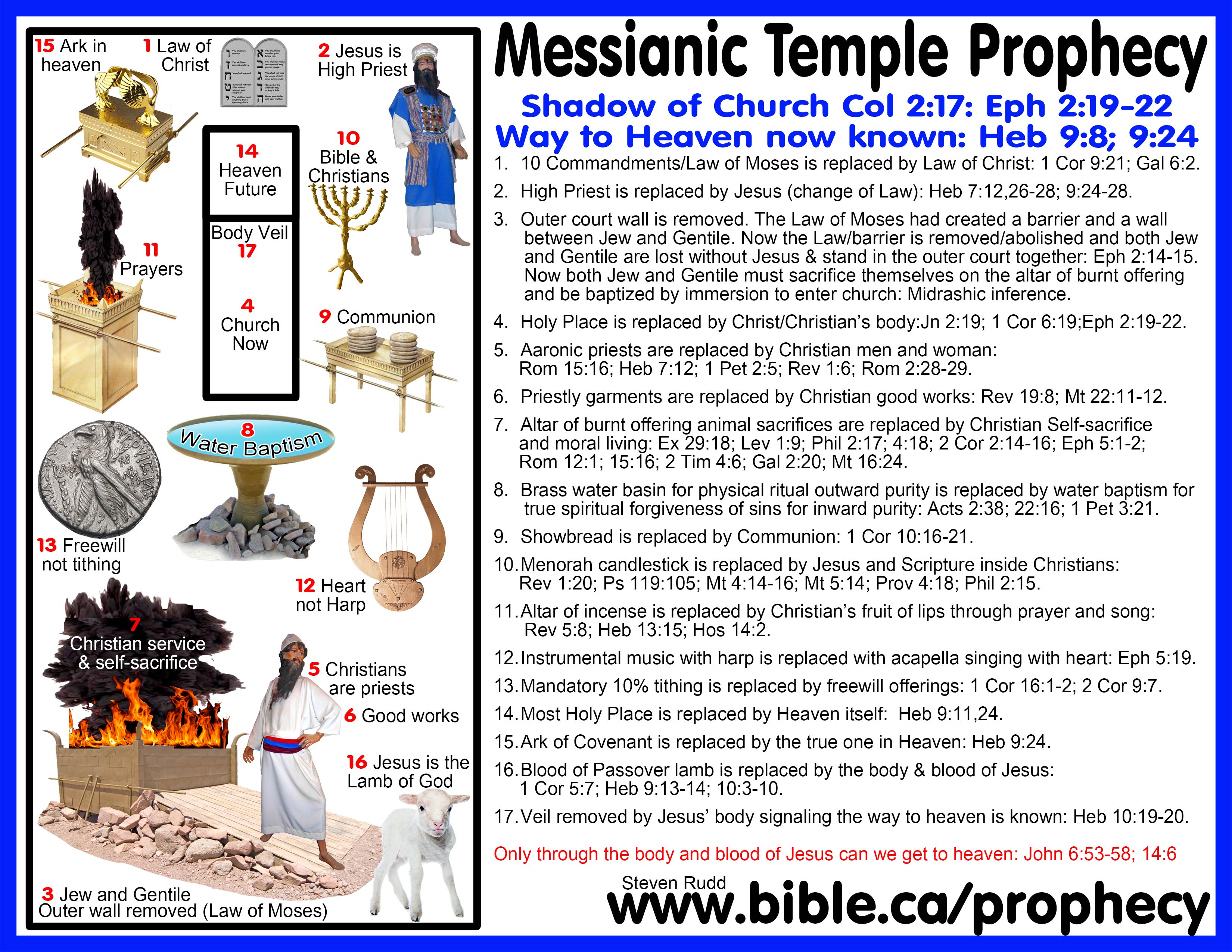
The Tabernacle Messianic Prophecy: “Shadow of what was to come” Col 2:17
- 10 Commandments/Law of Moses is replaced by Law of Christ: 1 Cor 9:21; Gal 6:2.
- High Priest is replaced by Jesus (change of Law): Heb 7:12,26-28; 9:24-28.
- Outer court wall is removed. The Law of Moses removed, which created a barrier between Jew and Gentile. Now the Law/barrier is removed/abolished and both Jew and Gentile are lost without Jesus & stand in the outer court together: Eph 2:14-15. Now both Jew and Gentile must sacrifice themselves on the altar of burnt offering and be baptized by immersion to enter church: Midrashic inference.
- Holy Place is replaced by Christ/Christian’s body: Jn 2:19; 1 Cor 6:19;Eph 2:19-22.
- Aaronic priests are replaced by Christian men and woman: Rom 15:16; Heb 7:12; 1 Pet 2:5; Rev 1:6; Rom 2:28-29.
- Priestly garments are replaced by Christian good works: Rev 19:8; Mt 22:11-12.
- Altar of burnt offering animal sacrifices are replaced by Christian Self-sacrifice and moral living: Ex 29:18; Lev 1:9; Phil 2:17; 4:18; 2 Cor 2:14-16; Eph 5:1-2; Rom 12:1; 15:16; 2 Tim 4:6; Gal 2:20; Mt 16:24.
- Brass water basin for physical ritual outward purity is replaced by water baptism for true spiritual forgiveness of sins for inward purity: Acts 2:38; 22:16; 1 Pet 3:21.
- Shewbread is replaced by Communion: 1 Cor 10:16-21.
- Minora candlestick is replaced by Jesus and Scripture inside Christians: Rev 1:20; Ps 119:105; Mt 4:14-16; Mt 5:14; Prov 4:18; Phil 2:15.
- Altar of incense is replaced by Christian’s fruit of lips through prayer and song: Rev 5:8; Heb 13:15; Hos 14:2.
- Instrumental music with harp is replaced with acapella singing with heart: Eph 5:19.
- Mandatory 10% tithing is replaced by freewill offerings: 1 Cor 16:1-2; 2 Cor 9:7.
- Most Holy Place is replaced by Heaven itself: Heb 9:11,24.
- Ark of Covenant is replaced by the true one in Heaven: Heb 9:24.
- Blood of Passover lamb is replaced by the body & blood of Jesus: 1 Cor 5:7; Heb 9:13-14; 10:3-10.
- Veil removed by Jesus’ body signaling the
way to heaven is known: Heb 10:19-20.
Only through the body and blood of Jesus can we get to heaven: John 6:53-58; 14:6
Additional Exodus route messianic Prophecies:
- The pillar of fire and the angel was the first physical appearance representing the presence of God on earth.
- This symbol went through a series of physical transformations.
- The presence of God in the Pillar of fire was replaced after they crossed the Jordan by the most holy place in the Tabernacle of Moses, which was replaced by the Temple of Solomon, which finally became the body of a Christian individually and the church collectively. (1 Corinthians 3:16-17; 6:19-20; Ephesians 2:19-22) see: detailed study
- The pillar of fire also represented the light of God's word that lights our path: Ps 119:105.
- God as "Our Rock" is a type of
the Rock
Moses struck for water. 1 Cor 10:4.
- Mt. Sinai is a type of the heavenly Jerusalem: Hebrews 12:18-24.
- Just as the Hebrews did not stumble "Like a horse in the desert", when they travelled day and night then crossed the Red Sea, so too Christians will never stumble if we walk in the light and imitate Jesus. (Isaiah 63:11-14; Psalm 105:37; 2 Peter 1:10-11)
- Our salvation from the slavery of sin happens when we are baptized into Christ, and is a type of the Red Sea crossing when they were saved from the slavery of Egypt and baptized into Moses: 1 Cor 10:1-4. Have you been baptized in water by full immersion as a believer in order to be saved?
|
|
Take this interactive online Bible study to learn about water baptism! |
|
|
Why not attend a good Bible believing local church in your own home town this Sunday that believes the exodus is real history. Click here to find the closest assembly of Christians to your house. |
|
|

|
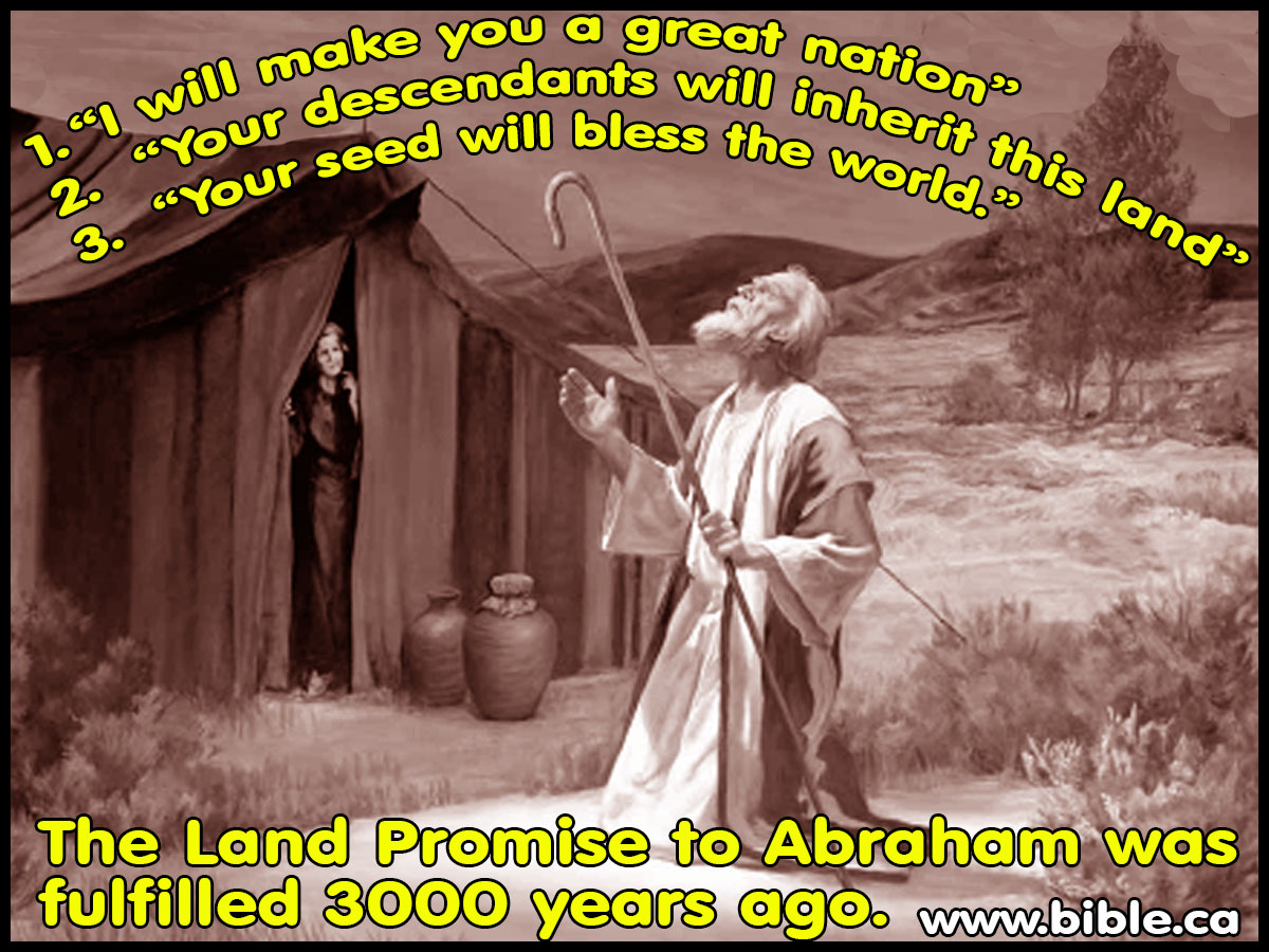
Three promises of Abraham fulfilled "But as the time of the promise was approaching which God had assured to Abraham, the people increased and multiplied in Egypt" (Acts 7:17) |
|||
|
|
Promised |
Physically fulfilled |
Spiritually fulfilled |
|
Great Nation |
Gen 12:1-7; 18:18; 22:17-18; 26:3-4; 28:13-14; 13:14-17; 15:5-21; 17:2-8; 48:4; Exod 32:13
|
Jews: Gen 46:3; Deut 1:10; 10:22; Heb11:11-12 |
Christians: Rom 4:16-17; Gal 3:29; Gal 4:28 |
|
Land |
Gen 12:1-7; 22:17-18; 26:3-4; 28:13-14; 13:14-17; 15:5-21; 17:2-8; 24:7; 28:4; 35:12; 46:3; 48:4; Ex 32:13; 6:2-8; 12:25; 13:5; 23:31; 33:1 |
Canaan: Deut 6:18; 9:5; 30:5 Josh 21:43-45; Josh 24:28; 2 Sam 8:3; 1 Ki 4:21; 2 Ki 14:25; 2 Chr 9:26; Neh 9:8; Ps 105:42-44; Jer 11:5; Ezek 20:42; Acts 7:17; 13:19; Rom 4:13 |
Heaven: Rom 4:13-14; Gal 3:18; 4:23-28; Eph 1:10-14; Heb 4:3; 6:11-13; 6:19-20
|
|
seed |
Gen 12:1-7; Gen 18:18; 22:17-18; 26:3-4; 28:13-14
|
none |
Christ: Acts 3:25-26; 13:32-33,38; Gal 3:8-9; 3:18,29
|
See also: Men who misled the world away from the Exodus route
|
Main Exhibit Keys that Unlocking the Exodus Route |
|
|
|
|
|
|
KEY#1 The Exodus was a Miracle: (Ex 13:21; Deut 8:4; 29:5; Neh 9:21) Can God prepare a table in the wilderness? Ps 78:19 |
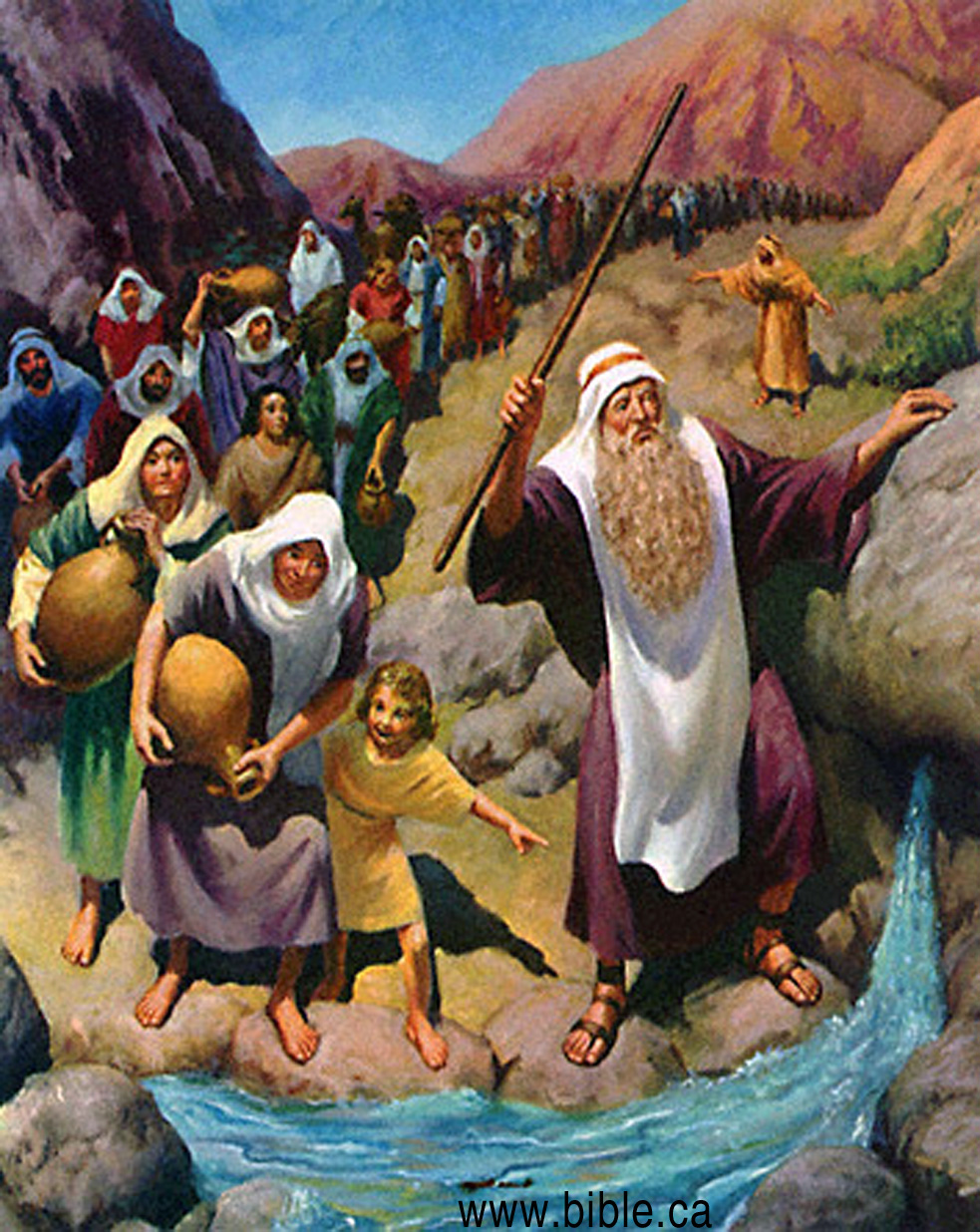
- The exodus was a miracle: Israel traveled 24 hours a day, day and night and their feet didn’t swell, never stumbled. Their cloths and shoes never wore out. They consumed manna and quail provided by miracle and water from a rock. The cloud sheltered them from both sun and rain. The pillar of fire gave them light at night and guidance on the journey.
- "The Lord went in front of them in a pillar of cloud by day, to lead them along the way, and in a pillar of fire by night, to give them light, so that they might travel by day and by night." (Exodus 13:21)
- "The clothes on your back did not wear out and your feet did not swell these forty years." (Deuteronomy 8:4)
- "I have led you forty years in the wilderness. The clothes on your back have not worn out, and the sandals on your feet have not worn out;" (Deuteronomy 29:5)
- "They asked, and He brought quail, And satisfied them with the bread of heaven. He opened the rock and water flowed out; It ran in the dry places like a river. " Psalm 105:37-41
- "Forty years you sustained them in the wilderness so that they lacked nothing; their clothes did not wear out and their feet did not swell." (Nehemiah 9:21)
- "When the Lord has washed away the filth of the daughters of Zion and purged the bloodshed of Jerusalem from her midst, by the spirit of judgment and the spirit of burning, then the Lord will create over the whole area of Mount Zion and over her assemblies a cloud by day, even smoke, and the brightness of a flaming fire by night; for over all the glory will be a canopy. There will be a shelter to give shade from the heat by day, and refuge and protection from the storm and the rain." Isaiah 4:4-6
- Echoing the exodus, Jeremiah says in 595 BC that at the end of the 70 year Babylonian captivity (which began in 605 BC), none who leave bondage for the promised land will stumble!. "Behold, I am bringing them from the north country, And I will gather them from the remote parts of the earth, Among them the blind and the lame, The woman with child and she who is in labor with child, together; A great company, they will return here. “With weeping they will come, And by supplication I will lead them; I will make them walk by streams of waters, On a straight path in which they will not stumble; For I am a father to Israel, And Ephraim is My firstborn.”" (Jeremiah 31:8–9)
- "Then He brought them out with silver and gold, And among His tribes there was not one who stumbled. Egypt was glad when they departed, For the dread of them had fallen upon them. He spread a cloud for a covering, And fire to illumine by night. They asked, and He brought quail, And satisfied them with the bread of heaven. He opened the rock and water flowed out; It ran in the dry places like a river. " Psalm 105:37-41
- "Then He brought them out with silver and gold, And among His tribes there was not one who stumbled." (Psalm 105:37)
- "Then they remembered the days of old, of Moses his servant. Where is the one who brought them up out of the sea with the shepherds of his flock? Where is the one who put within them his holy spirit, who caused his glorious arm to march at the right hand of Moses, who divided the waters before them to make for himself an everlasting name, who led them through the depths? Like a horse in the desert, they did not stumble. Like cattle that go down into the valley, the spirit of the Lord gave them rest. Thus you led your people, to make for yourself a glorious name." (Isaiah 63:11–14)
|
|
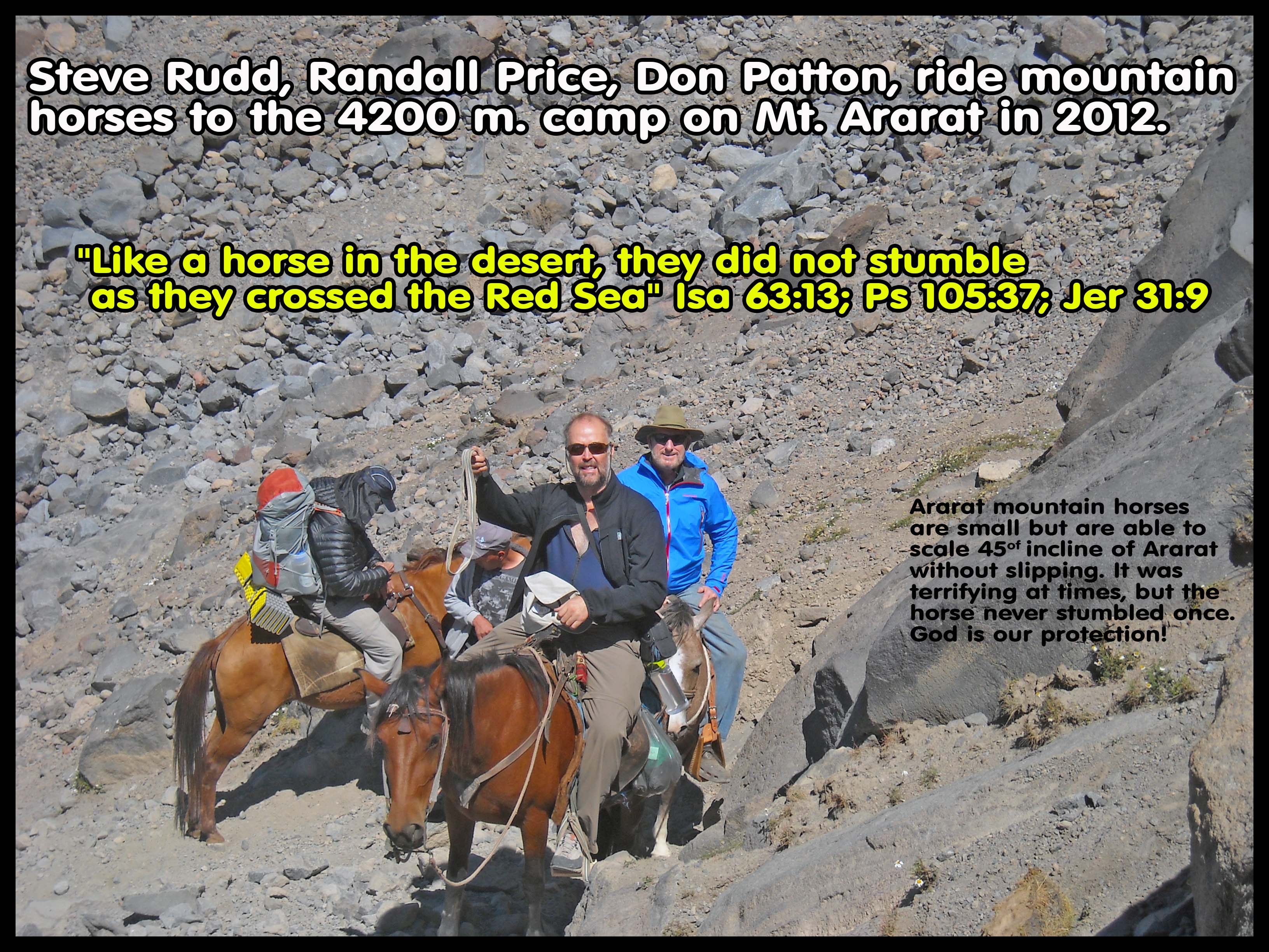
"Like a horse in the desert, they did not stumble as they crossed the Red Sea" Isa 63:13; Ps 105:37; Jer 31:9
Steve Rudd, Randall Price, Don Patton, ride mountain horses to the 4200 m. camp on Mt. Ararat during the 2012 Expedition to find Noah's Ark. Ararat mountain horses are small but are able to scale the 45-degree incline of Ararat without slipping. It was terrifying at times, but the horse never stumbled once. This is what Isa 63:13 means that God will provide, and His people should not be anxious! |
- They were given supernatural help travelling long distances so their feet did not swell and when crossing the Red Sea, none of the elderly tripped or fell down.
- The Exodus Highway is a flat coastal
plain that is 20 km wide and runs the full length of the 500 km journey
from Goshen to the Straits of Tiran. This coastal plain slowly rises from
sea level to the eastern mountains at 250 meters above sea level. Travel
would be fast and easy.
- "Then His people remembered the days of old, of Moses. Where is He who brought them up out of the sea with the shepherds of His flock? Where is He who put His Holy Spirit in the midst of them, Who caused His glorious arm to go at the right hand of Moses, Who divided the waters before them to make for Himself an everlasting name, Who led them through the depths? Like the horse in the wilderness, they did not stumble; As the cattle which go down into the valley, The Spirit of the Lord gave them rest. So You led Your people, To make for Yourself a glorious name." (Isaiah 63:11–14)
- “Indeed, forty years You provided for them in the wilderness and they were not in want; Their clothes did not wear out, nor did their feet swell." (Nehemiah 9:21)
- One of the biggest errors in determining the exodus route is in calculating distances and travel times.

- ERROR 1: Three days to Red Sea crossing point: "The three day journey to reach the Red Sea crossing point": Since there are three stops between Goshen and the Red sea crossing point, it is wrongly concluded that they only travelled three days. This seems like a solid conclusion given the fact that Moses asked Pharaoh to let Israel make a three-day journey to sacrifice to YHWH (Exodus 3:18). Notice however, this was all Moses knew at the time. Even while standing on the shore of the Red Sea, Moses had no idea that God would part the waters until God told him. And three days to what? Red Sea crossing? Mt. Sinai? So reject the idea that a three days journey is any help in determining the location of the Red Sea crossing point. Josephus gives almost no usable information in determining the Exodus route but he did say it took three days to reach the Red Sea in Antiquities 2.315. Many have been misled by Josephus with his statement who wrongly assumed the three stops between Goshen and the Red sea listed by Moses took three days. We have several passages that say Israel travelled day and night. Israel crossed the Red Sea on day 25.
- ERROR 2: Miscalculation of daily travel rates: "A group of three million could not move more than 15 km per day." Much effort is put into determining the number of kilometers per day that the exodus Hebrews could travel in a day. All this calculation is nullified by the fact that Israel travelled day and night with supernatural help. The 500 km journey from Goshen to the Straits of Tiran at a rate of only 29 km per day ensured they arrived at the Red Sea on day 17 days. They then waited an entire week for Pharaoh to arrive with his army and then crossed the Red Sea on day 25.
- Philo describes a long and difficult journey from Goshen to the Red Sea. He also describes how they were trapped by the sea which fits the Straits of Tiran. If this was the bitter lakes, they would simply go around the shore:
- "having accomplished together a long and desolate journey through the wilderness, destitute of any beaten road, at last arrived at the sea which is called the Red Sea." (Philo, On the Life of Moses, 2:247, Young, 1854 AD, Updated by Charles Duke, 1993 AD)
- Men and women alike, they had traversed a long and pathless wilderness, and arrived at the Red Sea, as it is called. They were then naturally in great difficulties, as they could not cross the sea for want of boats, and did not think it safe to retrace their steps. When they were in this state of mind, a greater misfortune burst upon them. The king of Egypt, accompanied by a very formidable body of infantry and cavalry, came in hot pursuit, eager to overtake them and so chastise them for leaving the country. He had, indeed, permitted them to do so, induced by unmistakable warnings from God. But the disposition of the wicked is, as may be well seen, unstable, suspended as it were on a balance and swayed up and down by the slightest cause in opposite directions. Thus, caught between the enemy and the sea, they despaired each of his own safety."" (Philo, Moses II 247-249, Harvard, 1962 AD)
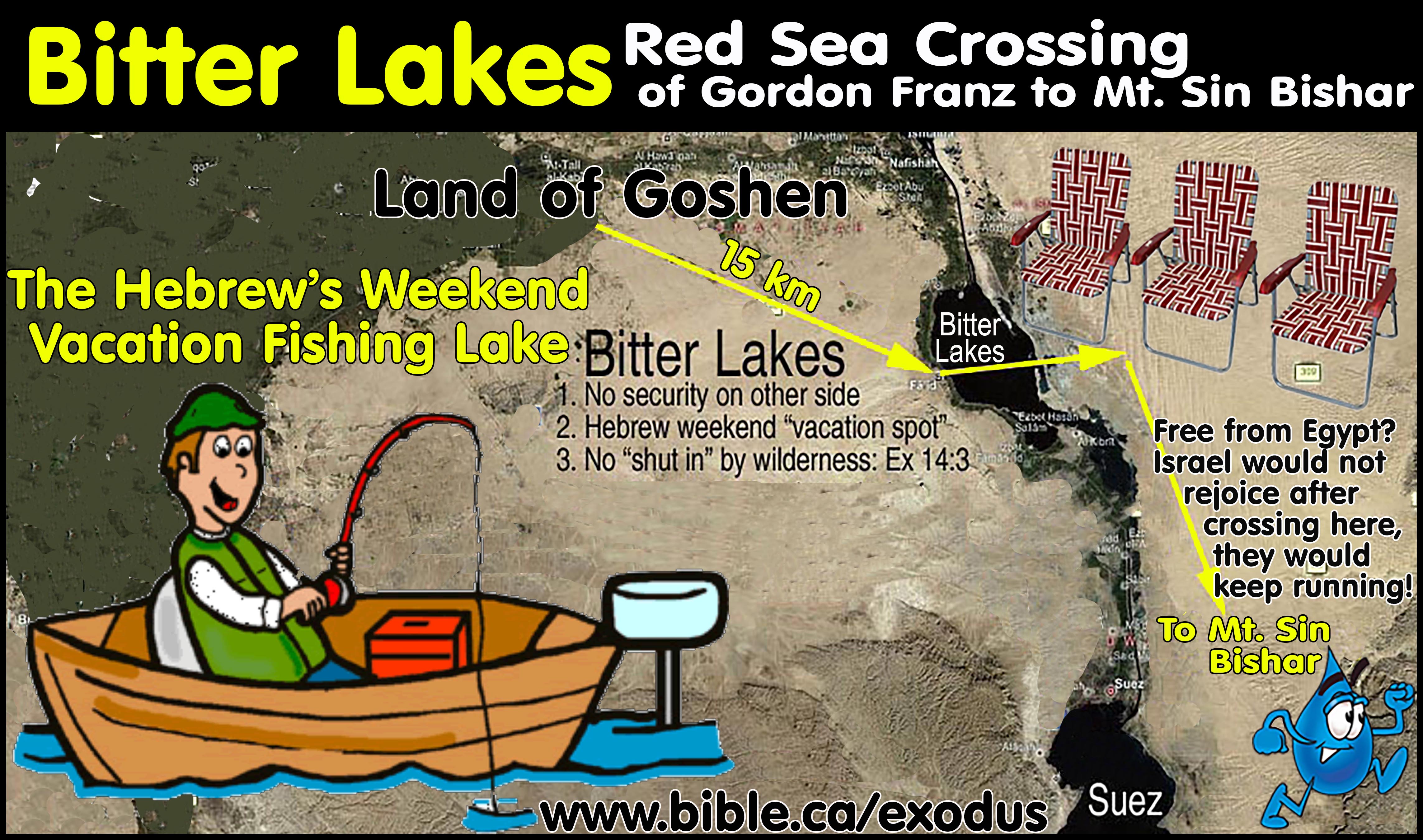
- This essentially guts the idea that they would travel such a short distance to cross at the Ballah, Timsah, Bitter lakes, or the Gulf of Suez. Israel would never need to cross through these small lakes, they would simply go around. If they did cross the Egyptians would not follow but follow the shore to the other side.
- The total journey took 47 days. Israel
crossed the Red sea on day 25 after which the Bible narrative starts
counting 22 days till they reach Sinai on day 47. Those who propose a Red
Sea crossing at Ballah, Timsah, Bitter lakes, or the Gulf of Suez fail to
realize these were the weekend fishing holes and vacation spots of the
Hebrews in while they lived in Goshen.
- Gordon Franz's "7-day challenge" to walk from Goshen to the Straits of Tiran is ill informed given Israel crossed on day 25 and they miraculously travelled day and night (Exodus 13:21).
- Humans walk at 5 km per hour. If Israel walked 3 hours, had a two-hour lunch then walked 3 more hours, they would travel 30 km per day. More details: Travel times, distances, days of the week
|
Trip |
Distance |
Total days |
Camp days |
Travel days |
Daily rate of travel |
|
Goshen to Red Sea
(including Etham backtrack and Red Sea crossing) |
500 km |
24 |
7 |
17 |
29 km/day 18 miles/day |
|
Red Sea to Sinai |
200 km |
22 |
11 |
11 |
18 km/day 11 miles/day |
|
Goshen to Sinai (including Etham backtrack 44 km and Red Sea crossing 16 km) |
700 km |
47 |
18 |
29 |
24 km/day 14 miles/day |
|
|
|
|
|
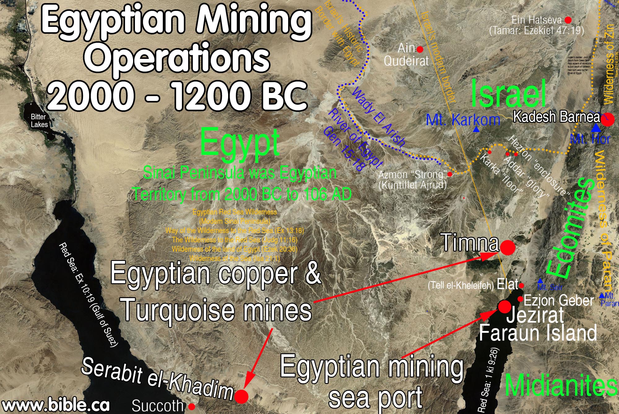
KEY#2 The Succoth Stop: Hebrew miners at Serabit el-Khadim join Moses. The stop at Succoth was not to rest, it was to collect the Hebrew workers at the Egyptian controlled copper and turquoise mines Serabit el-Khadim. They travelled day and night by miracle. |
1. The stop at Succoth was not to rest, it was to collect the Hebrew workers at the Egyptian copper and turquoise mines Serabit el-Khadim.
a. See detailed outline on Succoth.
b.
Two Egyptian copper/turquoise mines were in full
operation in 1446 BC in the Sinai:
2. It is important to understand that Israel travelled day and night without stopping.
a. "The Lord was going before them in a pillar of cloud by day to lead them on the way, and in a pillar of fire by night to give them light, that they might travel by day and by night. He did not take away the pillar of cloud by day, nor the pillar of fire by night, from before the people." Exodus 13:21-22
b. See also: Miracles of the Exodus and Red Sea Crossing
3. They likely stopped for brief food breaks to eat their unleavened bread.
a. "The Egyptians urged the people, to send them out of the land in haste, for they said, “We will all be dead.” So the people took their dough before it was leavened, with their kneading bowls bound up in the clothes on their shoulders." (Exodus 12:33–34)
b. They did not stop to set up tents or sleep.
c. This changes all the “how many miles did they travel in a day” calculations.
d. See also: Travel times, distances, days of the week.
5. Several
of the recently translated 16 “Sinai Inscriptions” document Hebrew life at
Serabit el-Khadim.
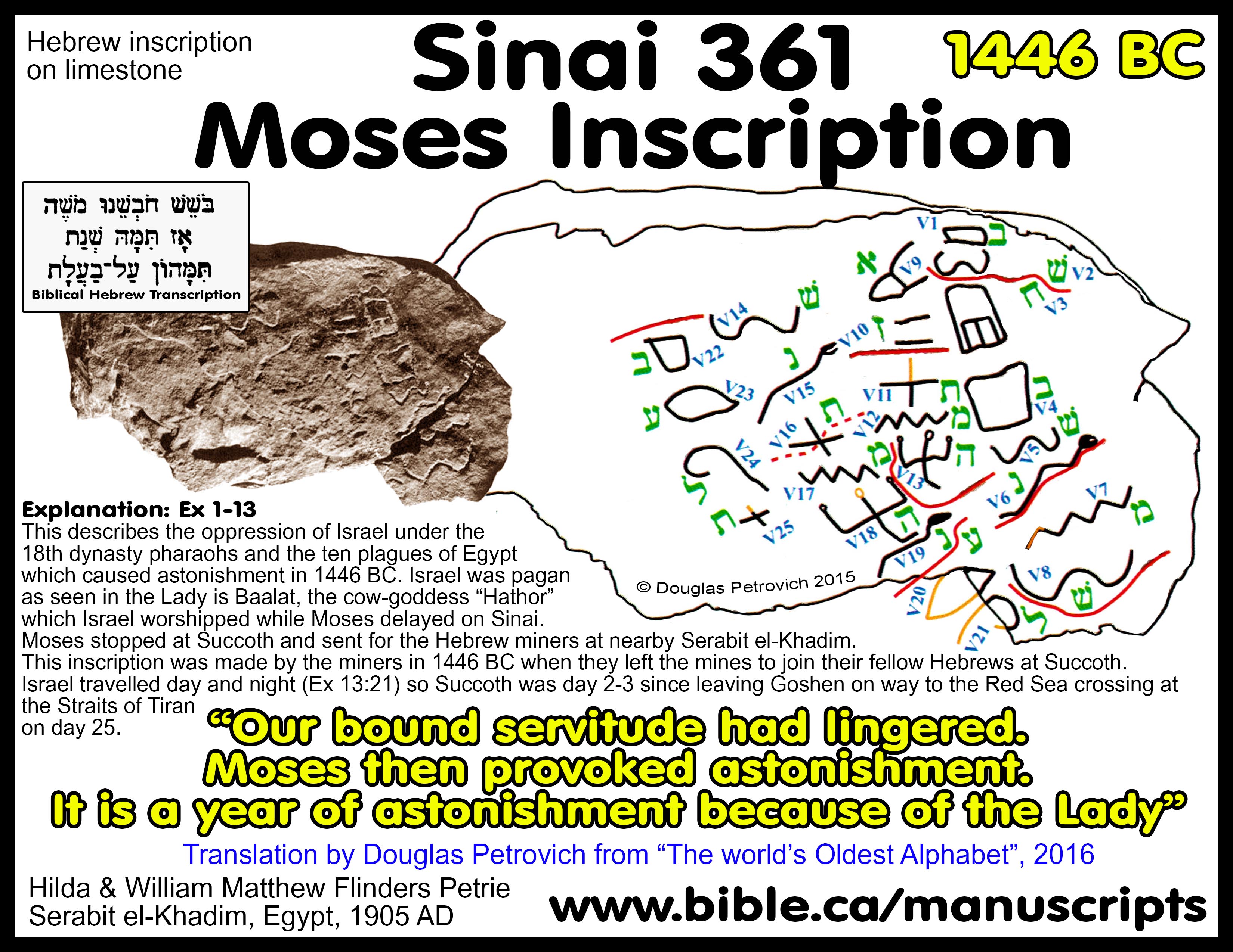
a. Pictured above is Sinai Inscription #361 (dated to 1446 BC) which translates from Hebrew into English, “Our bound servitude had lingered. Moses then provoked astonishment. It is the year of astonishment because of the Lady [Hathor-the cow goddess]”. See details: Sinai Moses Inscription 361”.
b. Sinai inscriptions #115, 345, 349, 353, 357, 360, 361, 275a, were all excavated by Flinders Petrie at Serabit el-Khadim in 1905 AD.
c. The language was unknown and they sat in museums till Douglas Petrovitch recognized them as Hebrew and translated them in 2016 AD.
d. The now famous “Moses Inscription” (Sinai 361) is the first archeological confirmation of Moses ever to be discovered.
e. The inscriptions are proof of a sizable slave population working at the mines.
f. See also: 16 Sinai Inscriptions”.
6. Moses would know about this slave population working at the mine and he would certainly stop to collect the men.
a. These men would have wives and children asking Moses to stop and get their husbands and fathers.
b. Moses could send runners ahead of the main group to instruct them to start packing up and make the short trip.
7. Distances between Succoth and the mines at Serabit el-Khadim
a. Succoth to the mines at Serabit el-Khadim: 20 km over mountains, 40 km around the mountains.
b. Succoth and the mines at Bir Nasb: 12 km over mountains, 25 km around the mountains.
c. This journey is an easy day trip for the slave miners to join Moses camped at Succoth.
8. Today, there is a road that follows the valleys in the mountains between the beach and Bir Nasb, then continues to Serabit el-Khadim. This route is likely an ancient pathway used by the Hebrews and is only 20 km to Serabit el-Khadim.
|
|
|
|
|
KEY#3 The Etham Dilemma: "The Great Backtrack when they hit THE WALL" Only the Straits of Tiran fit the geography of Exodus 14:2-3 |
"Tell the sons of Israel to turn back and camp before Pi-hahiroth, between Migdol and the sea; you shall camp in front of Baal-zephon, opposite it, by the sea. “For Pharaoh will say of the sons of Israel, ‘They are wandering aimlessly in the land; the wilderness has shut them in." (Exodus 14:2-3)
- When Israel reached Etham, they hit a huge impassable mountain range.
a. Etham may be derived from Egyptian word for wall/fortification. Hb. šûr = “wall” and Egyptian htm = “wall, fortress”. "Etham is simply Egyptian for Hebrew Shur, both meaning “wall, fortification.”." (The JPS Torah Commentary: Numbers 33:8, 1999 AD)
b. The mountains they hit were known as "THE WALL" or THE ETHAM.
- God told them "now turn back" (backtrack and retrace their steps) and camp at what would be the crossing point of the Red Sea.
- This is how God "baited" Pharaoh to say, "They are wandering aimlessly in the land; the wilderness has shut them in".
- No other crossing point can satisfy the "Etham Dilemma" where they pass the final camping spot and stop at Etham because of the mountains, then backtrack to the camp where they would cross the Red Sea. Only the Straits of Tiran make Etham work!
- Red Sea crossing points at Ballah, Timsah, Bitter lakes, Suez or the Nuweiba beach fail to meet the Bible requirement and for them, the Etham backtrack is a huge Dilemma. Etham is one of the most interesting and most important locations for determining the exodus route and the crossing of the Red Sea.
- This essentially guts the idea that they would travel such a short distance to cross at the Ballah, Timsah, Bitter lakes, or the Gulf of Suez. Why would Israel even cross through these small lakes? They would simply go around because NOTHING was "trapping them". It’s simple details like these that most miss when considering the Red Sea crossing point.
2. Philo also records that Israel was "enclosed like a shoal of fish" and trapped at Etham by the geography. Today we know this trapping was because at Etham, the huge mountain range crossed to the edge of the Gulf of Aqaba, making the northern coastal land route impassable.
- "and not being able to escape, for behind was the sea, and in front was the enemy, and on each side a vast and pathless wilderness" (Philo, On the Life of Moses, 1:165-171, Young, 1854 AD, Updated by Charles Duke, 1993 AD)
- "But when the prophet saw that the whole nation was now enclosed like a shoal of fish, and in great consternation, he no longer remained master of himself, but became inspired, and prophesied as follows: " (Philo Moses II 250, Young, 1854 AD, Updated by Charles Duke, 1993 AD)
- All other proposed crossing points
except for the Strait of Tiran have no geographical means of
"TRAPPING" Israel. In other words, crossing points at Ballah,
Timsah, Bitter lakes, Suez or the Nuweiba beach fail to trap Israel at
Etham, forcing them to backtrack and camp at the final crossing point
while waiting for Pharaoh to arrive. The Bible narrative indicates they
passed by the final Red Sea camp and hit the dead end at Etham, then
backtracked to camp at the place they passed the day before.

3. There are a number of ways of viewing the Wilderness of Etham:
a. It may be derived from Egyptian word for wall/fortification. Hb. šûr = “wall” and Egyptian htm = “wall, fortress”. "wilderness of Etham Although identified as Shur in Exodus 15:22, this need not imply two versions. Etham is simply Egyptian for Hebrew Shur, both meaning “wall, fortification.”" (The JPS Torah Commentary: Numbers 33:8, 1999 AD) After crossing the Red Sea, they went three days into the wilderness of Shur. Therefore, the Wilderness of Etham is identical to the Wilderness of Shur.
b. It may be a textual gloss: Etham is not found in the Septuagint (LXX) in Number 33:8. The "Wilderness of Etham" may not exist. It is only found in one passage: Num 33:8. Etham is not in the LXX at Num 33:8. Instead, the Septuagint has the word, "they" which is spelled almost the same, with the vowels removed. Perhaps the Masoretes erred when they added the vowels. Many commentators completely ignore it in Num 33:8.
c. It may simply mean there is a place called Etham on both sides of the Gulf of Aqaba at the straits of Tiran.
d. Perhaps the Straits of Tiran were viewed as a "wall" from both sides. On either side there was no place to go except to backtrack or cross to the other side. It was a dead end on both sides! Thus THE WALL.
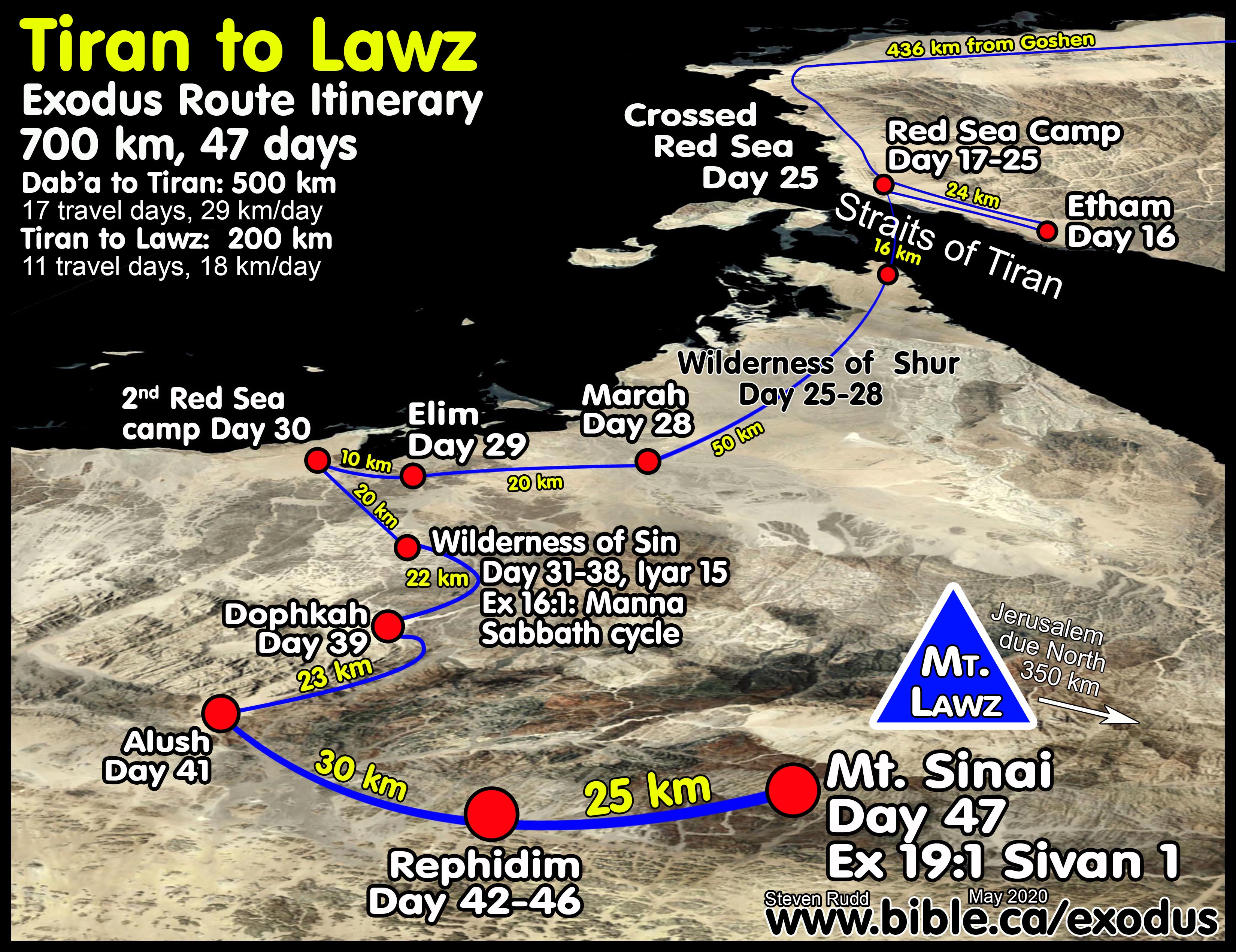
- The 700 km journey from Goshen to Sinai took 47 days.
- The exodus was a miracle and Israel traveled 24 hours a day, day and night (Exodus 13:21). God gave young and old supernatural help so that they NEVER stumbled: Isaiah 63:12–14; Psalm 105:37.
- The 400 km trip from Goshen (Tel El-Daba) to the Straits of Tiran is a flat 18 km wide packed sand terrain and is absolutely perfect for travel with no ups and downs. It is a virtual highway! I have PERSONALLY travelled it and have photos demonstrating how perfect it is for easy quick travel. But this path ends with an abrupt mount range just past Tiran at Etham. God told them to stop, turn back, retrace their steps and camp at the crossing point of the Red Sea under the Egyptian Migdol watchtower located at the tri-intersection water way. (Ex 14:2, Num 33:7)
- They arrived on day 17 at the Straits of Tiran. Israel crossed the Red sea at the Straits of Tiran on day 25 after which the Bible narrative starts counting 22 days till they reach Sinai on day 47.
- Word was sent back to Pharaoh that Israel was trapped via passenger pigeon from the overlooking Migdol in 5 hours as message something like this: "They are wandering aimlessly in the land; the wilderness has shut them in." (Ex 14:3) The Egyptian Migdol (literally watchtower) at the triple junction forks of the Red Sea was one of the most important ones, of the more than 60 known "migdols" in Egypt and they would clearly report the exact movements of Israel to Pharaoh. Israel camped 8 days as Pharaoh raced by chariot to the scene down the sandy Egyptian highway and arrived at Tiran on day 25 giving plenty of time for the stragglers to reach the camp. After crossing at Tiran they spent 20 days getting to Sinai on day 45, which includes 8 days camping at Sin to learn the Sabbath cycle.
|
Click on image for Hi Resolution
|
The Etham dilemma is utterly ignored since all other proposed Red Sea crossings provide no block, stop, wall or trapping and the need to retrace and camp at the crossing point. The very idea that Israel was outside Egypt's control after crossing at the Bitter Lakes (the Hebrew's weekend fishing vacation spot while they lived in Goshen) or the major Egyptian seaport on the north shore of the Gulf of Suez (I would not rejoice after crossing, I would keep running) is unconscionable. In fact, the Straits of Tiran provide the only workable geography to solve the Etham dilemma. After crossing at Tiran into Saudi Arabia, they were truly "out of Egyptian control". Only then did they rejoice in the Wilderness of Shur, the historic homeland of Ishmael and Jethro of Midian.
|
- Only the Straits of Tiran are workable, given they came to Etham, stopped when they hit the mountain range, and then retraced their steps to camp at the crossing point to wait for the Egyptians to arrive 7 days later.
- Only a crossing at the gulf of Aqaba works and only the Straits of Tiran fit the "Etham backtrack" narrative.
- And if I just crossed the "Red Sea" at the Ballah, Timsah or Bitter lakes or the north end of the Gulf of Suez, I would not rejoice, I would keep running to escape the Egyptians!
- Notice that 90% of the crossing distance is very shallow and that one short section (about 2 km) was 205 meters deep.
- This is where God supernaturally assisted the Hebrews "Like the horse in the wilderness, they did not stumble" (Isaiah 63:11–14) and where Pharaoh's army drowned as he watched safely on the shore.
- Pharaoh survived the Red Sea the army did not:
|
|
Remember, the Bible nowhere says that Pharaoh (Thutmoses III) drowned in the Red Sea: "But He overthrew [literally: shook off not drowned or killed] Pharaoh and his army in the Red Sea, For His lovingkindness is everlasting." (Psalm 136:15)
NO CHARIOT WHEELS!!! Chariots were built 100% of wood and floated hundreds of kilometers from the Red Sea crossing site.
|
|
|
|
|
|
KEY#4 The Ignored second Red Sea camp |
- The body of water that is the RED SEA, must be large enough to facilitate first a crossing, then the second camp after crossing. Only a crossing at the Straits of Tiran allows for a workable second Red Sea camp in the same body of water.
- From scripture and historic references, the Red Sea most certainly includes many bodies of oceanic water:
- AD 100: Pliny the Younger explains that “erythra Thalassa” is equal to “mare rubrum”: “The sea [Indian Ocean] then makes a two-fold indentations in the land upon these coasts, under the name of Rubrum or “Red,” given to it by our countrymen; while the Greeks have called it Erythrum, from king Erythras, or, according to some writers, from its red colour, which they think is produced by the reflection of the sun’s rays; others again are of opinion that it arises from the sand and the complexion of the soil, others from some peculiarity in the nature of the water. (24.) Be this as it may, this body of water is divided into two gulfs. The one which lies to the east is called the Persian Gulf, and is two thousand five hundred miles in circumference, according to Eratosthenes. Opposite to it lies Arabia, the length of which is fifteen hundred miles. On the other side again, Arabia is bounded by the Arabian Gulf. The sea as it enters this gulf is called the Azanian Sea.” (Pliny, Natural History 6.28)
- The Gulf of Suez: Exodus 10:19 refers in our opinion to the Gulf of Suez. The argument that “Red Sea” is never used of the Gulf of Suez is unnecessary to prove a Mt. Sinai in modern Saudi Arabia. Having said this, there are very few certain references in the Bible to the Gulf of Aqaba being the Red Sea. In fact, the reference in Ex 10:19 might be saying that the “sea wind/west wind” blew the locust into the gulf of Aqaba. "So the LORD shifted the wind to a very strong west wind which took up the locusts and drove them into the Red Sea; not one locust was left in all the territory of Egypt." (Exodus 10:19) Herodotus comments on the construction of the Suez Canal: “Psammetichus had a son, Necos, who became king of Egypt. It was he who began building the canal into the Red Sea, which was finished by Darius the Persian. This is four days’ voyage in length, and it was dug wide enough for two triremes to move in it rowed abreast. [2] It is fed by the Nile, and is carried from a little above Bubastis by the Arabian town of Patumus; it issues into the Red Sea.” (Herodotus 2.158). “There is another canal [Suez Canal] also, which empties itself into the Red Sea, or Arabian Gulf, near the city Arsinoë, which some call Cleopatris. It flows through the Bitter Lakes, as they are called, which were bitter formerly, but when the above-mentioned canal was cut, the bitter quality was altered by their junction with the river, and at present they contain excellent fish, and abound with aquatic birds.” (Strabo 17.1.25)
- The Gulf of Aqaba: Exod 23:31; Num 14:25; 21:4; Deut 1:40; 2:1; 1 Kgs 9:26; Jer 49:21. Via Nova Traiana: “Tell-tale signs of the course of the Via Nova Traiana include walled forts and interior structures, reservoirs, aqueducts, a Roman bridge, and the Trajanic triumphal arch at Petra. Actual stretches of preserved paved roadway itself have been located by a host of researchers. But it is the numerous milestones that most clearly mark both the actual alignment of the highway, and most plainly signals the artery’s strategic value to the Roman imperium. To date, nearly 275 milestones have been discovered in close proximity to the Via Nova between the sites of Bostra and Aila/Aqaba (none antedating Trajan). Some 42 of these have been found in the southernmost segment, between Petra and Aila. At least 25 inscribed Trajanic milestones or fragmentary specimens along the transportation artery, all firmly dating between AD 111-114 and discovered at findspots ranging from the vicinity of Bostra to Aila/Aqaba—contain a formulaic inscription that is of seminal relevance to this essay: viam novam a finibus Syriae usque ad mare rubrum aperuit et stravit [“a new highway was opened and paved from the border of Syria as far as mare rubrum”]. This formula makes explicit the fact that the Via Nova led to and directly joined the mare rubrum [=Gulf of Aqaba and the city of Aila/Aqaba]… Moreover, the conviction that Trajan’s road met the Red Sea at Aila/Aqaba, and not at some other place, is reinforced by the fact that several of the milestones were found south of where the modern road to Ramm, Egra and Medina diverges SE. If additional confidence in these data is desired, the security of this conviction becomes even more decisive by virtue of the fact that 5 of the milestones are thought to have been originally erected in the vicinity of Kh. al-Kithara, inside the confines of the canyon-like Wadi Yutm and at a site along the road just 20 km northeast of Aqaba. Two of these Kithara stones manifest inscribed Trajanic titulary, and one contains the entire Via Nova Traiana formula. MacAdam flatly declares (1986:21)—“’To the Red Sea’ can mean only one thing—the road terminated in the far south at the gulf of ‛Aqabā, more specifically at the port of Aela.”” (The Red Sea in Biblical, Classical and Early Cartographically related traditions, Barry J. Beitzel, NEAS annual meeting, 2016 AD)
- The Bay of Bengal: Philostratus, Apollonius 3.50.2 refers to the Bay of Bengal as “Erythra Thalassa” “Apollonius traveled [from the vicinity of Taxila, Pakistan] along the Ganges river for ten days until he reached the coast of Erythra Thalassa [Heb: yam sûf; Gk: erythra thalassa], the deepest blue sea which gets its name from [king] Erythras, who named the sea after himself; from the Ganges, Apollonius then sailed west and eventually passed the mouth of the Indus river.” (The Red Sea in Biblical, Classical and Early Cartographically related traditions, Barry J. Beitzel, NEAS annual meeting, p1, 2016 AD)
- Indian Ocean: “That Cyrus’s empire was the greatest and most glorious of all the kingdoms in Asia—of that it may be its own witness. For it was bounded on the east by the Indian Ocean [Literal Greek: Erythra Thalassa = Heb: yam sûf], on the north by the Black Sea, on the west by Cyprus and Egypt, and on the south by Ethiopia. And although it was of such magnitude, it was governed by the single will of Cyrus; and he honoured his subjects and cared for them as if they were his own children; and they, on their part, reverenced Cyrus as a father.” (Xenophon, Cyropaedia 8.8.1) “Livy 42.52.14—the Roman ancestors subdued all of Europe, crossed into Asia, and with their weapons they opened up a whole world that had been previously unknown even to rumor; they did not discontinue their conquests until, reaching the barrier of Rubro mari [Red Sea], there was nothing left to conquer (N.B. 42.52.15a—ultimis Indiae oris—"farthermost shores of India;" Eutropius 8.3—the emperor Trajan conquered Persia, Seleucia, Ctesiphon, Babylon, and Edessiani, and carried everyone before him as far as the coasts of India and mare Rubrum) [see also Aristides, Panathenaic Oration 119; Valerius Flaccus, Argonautica 5.77].” (The Red Sea in Biblical, Classical and Early Cartographically related traditions, Barry J. Beitzel, NEAS annual meeting, p1, 2016 AD)
- Persian Gulf: Diodorus 2.11.1-2 “the Tigris and Euphrates rivers, which have their headwaters in the Armenian mountains, enclose Mesopotamia and give this name to the country; after passing through Babylonia, these rivers empty into Erythra Thalassa [Greek: Erythra Thalassa = Heb: yam sûf]; cf. Eusebius 901/164:7-9; Calvin, Genesis (Baum, Corpus Reformatorum 1882 ed, vol. 23, col. 42)” (The Red Sea in Biblical, Classical and Early Cartographically related traditions, Barry J. Beitzel, NEAS annual meeting, p1, 2016 AD)
- Gulf of Aden: “Claudius Ptolemais 6.7.1-2. Arabia Felix [the southwestern Arabian Peninsula] is terminated on the north by Arabia Petraea, on the northeast by the Persian Gulf, on the west by the Arabian Gulf, and on the south by [Greek] Erythra Thalassa (= Hebrew yam sûf)[N.B. the expression is employed here in contradistinction to both the Persian Gulf and the Arabian Gulf.” (The Red Sea in Biblical, Classical and Early Cartographically related traditions, Barry J. Beitzel, NEAS annual meeting, p1, 2016 AD)
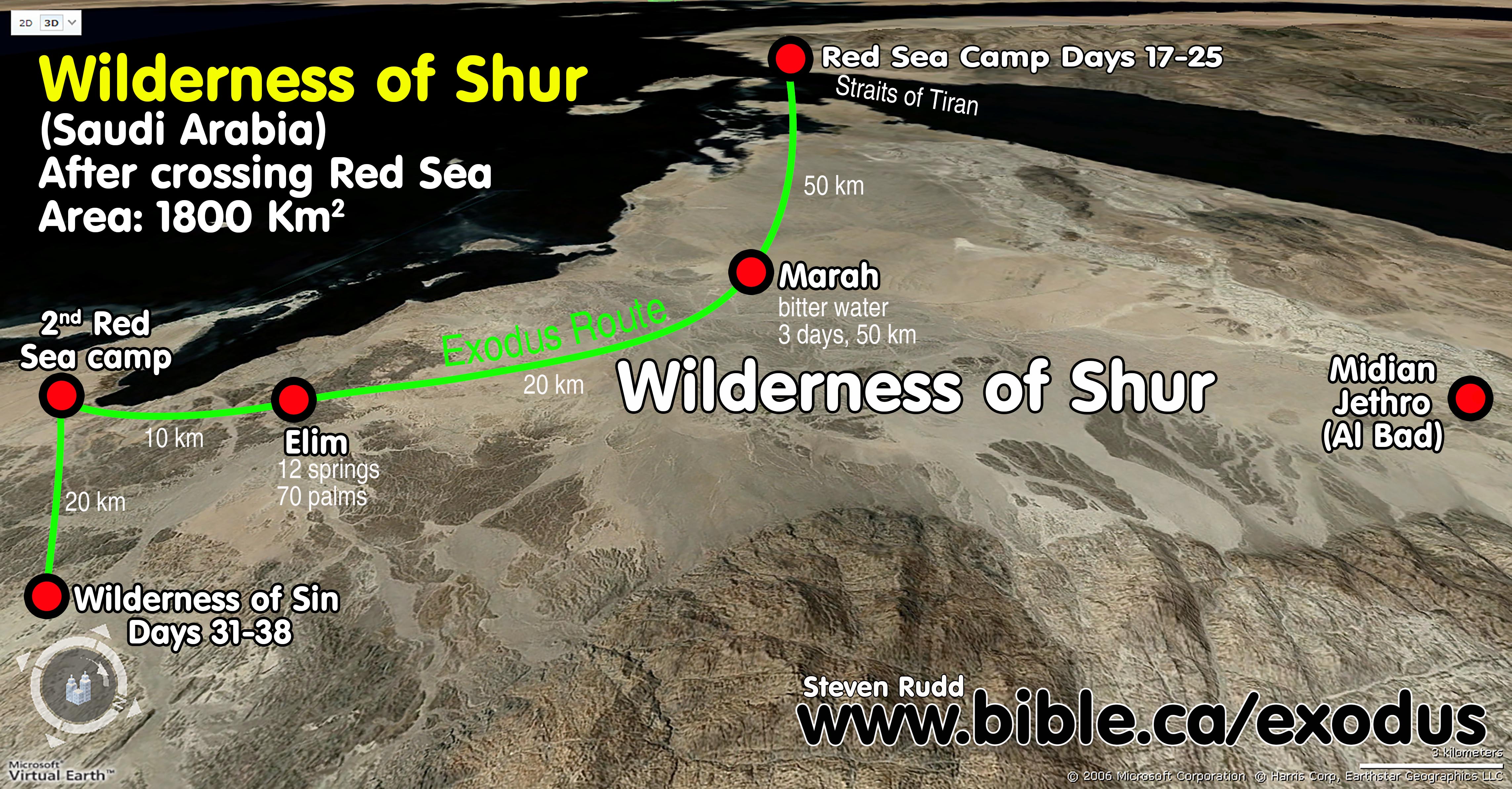
- The itinerary is as follows:
- Three days in the wilderness of Shur (Midian) to reach Marah
- Elim: day 4
- Second red sea camp: day 5: "They journeyed from Elim and camped by the Red Sea. They journeyed from the Red Sea and camped in the wilderness of Sin." (Numbers 33:10–11)
- Wilderness of Sin
- The second Red Sea camp is a huge problem for all who propose a Red Sea crossing at Ballah, Timsah or Bitter lakes. Most of the time their maps simply ignore it altogether.
- Even worse, a Red Sea crossing at Lake Timsah, would force the second Red Sea camp to be on the REAL Red Sea directly beside the major Egyptian sea port on the north shores of the Gulf of Suez.
- Red Sea NOT Sea of Reeds. Those who say the Red Sea crossing was at the freshwater lakes of Ballah Lake, Timsah Lake or the Bitter lakes always insist that "Red Sea" = "freshwater sea of reeds".
- They always go into a long study of the Hebrew original. Although the same word "suph" (Red) is used of a freshwater "reeds/plants" in Exodus 2:3 and Isaiah 19:6, we can be certain that Ezion-Geber was on the SALTY Red Sea near Elat in the Territory of Edom: "King Solomon also built a fleet of ships in Ezion-geber, which is near Eloth on the shore of the Red [suph] Sea, in the land of Edom." (1 Kings 9:26)
- The fact that the Masoretic Hebrew Text uses “sea of reeds” is irrelevant since the Gulf of Aqaba is also called the “sea of reeds” many times in the Masoretic text: 1 Kings 9:26; Jeremiah 49:21; Deut 1:4,40; 2:1.
- The Hebrew word used for freshwater reeds in Exodus 2:3 and Isaiah 19:6, may refer to their red colour. The "flower" of cattails and most reed plants are reddish coloured. When they reach the end of their cycle of life, they turn reddish brown before they die. This gives the shore a red colour from offshore.
- “Red” in Exodus 2:3 and Isaiah 19:6 is referring to a plant not a lake or a body of water!
- No ancient historian ever called the Ballah, Timsah or Bitter lakes the Red Sea and referring to them as the SEA OF REEDS is a modern fiction to support a wrong and failed exodus route.
- Herodotus used the Greek word for RED in describing the Red sea: "there is a gulf extending inland from the sea called Red" (Herodotus, Hist. 2.11.1)
- When pressed for a second Red Sea camp, freshwater lake advocates will then choose the SALTY Gulf of Suez as the second RED SEA camp. Did you catch that? After arguing vociferously that Red Sea means "sea of reeds" saying, "ITS IN THE HEBREW and is a freshwater lake!!!" they then place the second Red sea camp on the Gulf of Suez where NO REEDS GROW.
- The clincher is that the Holy Spirit inspired New Testament writers to use “Red Sea”, which confirmed the translation of the Septuagint. The Greek word used in the New Testament for Red Sea. is the colour red.
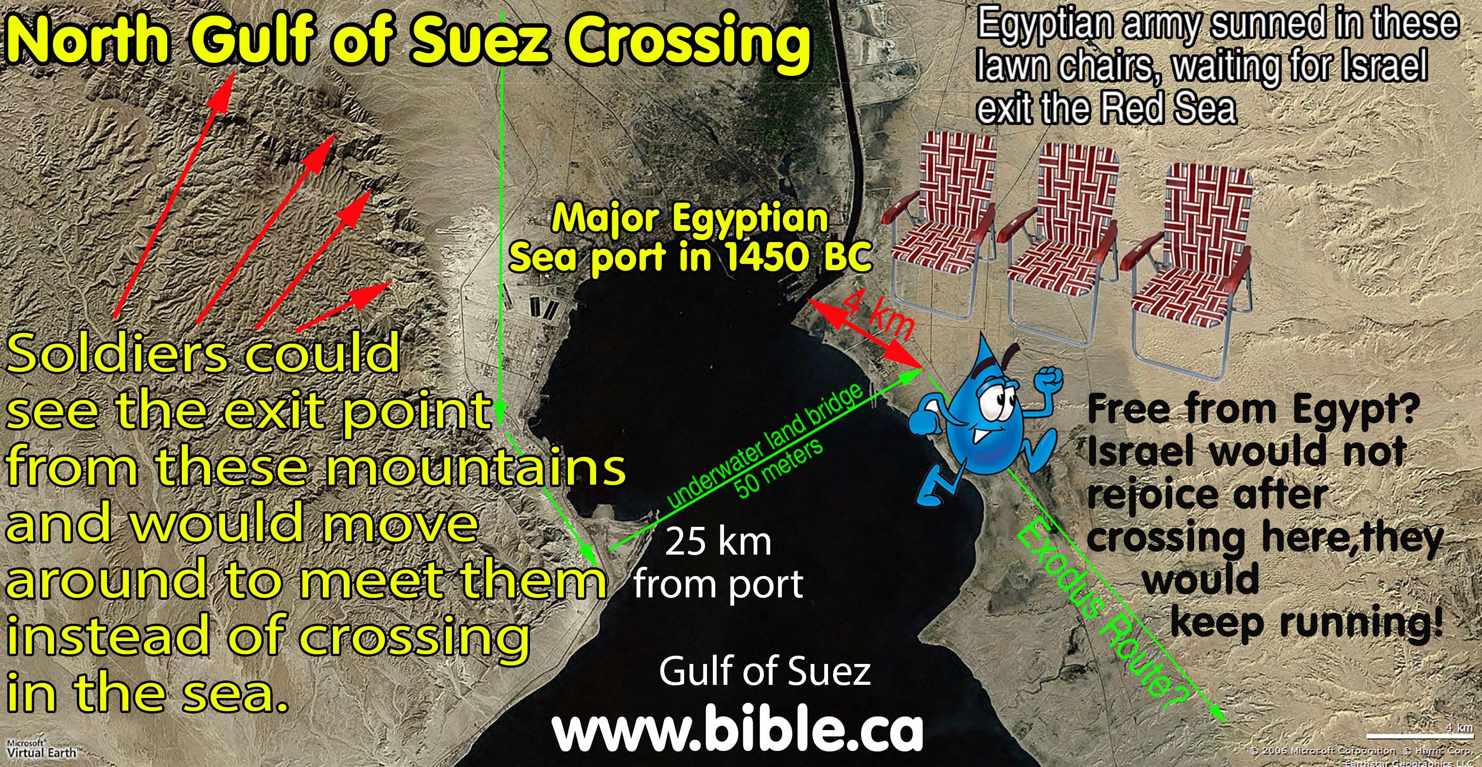
- Since the Red Sea is a large salty ocean body of water, we only have two choices: The Straits of Tiran and the north Gulf of Suez crossing.
- The Suez crossing is even a more troublesome than the freshwater lakes because the crossing point for the FIRST Red Sea crossing is at the location of a major shipping port for Egypt.
- The Egyptians would sit on lawn chairs waiting for Israel to come to them while sipping on an organic latte made from real GMO free goat milk! They wouldn't even need to leave the army barracks. They would just wait for Israel to come to them.
- The high hills on the west side of the Gulf of Suez would allow the Egyptians to see the entire path of the Red Sea crossing and simply go around to the other side, which is faster and easier than going through the ocean.
- To suggest they were free from Egyptian military control after crossing is absurd.
- Israel would not rejoice after crossing
directly into a major Egyptian seaport, THEY WOULD KEEP RUNNING FOR THEIR
LIFE and wonder what God is doing.

|
|
|
|
|
KEY#5 "Journey in stages" though mountains and difficult terrain: Ex 17:1 |
- Bible texts:
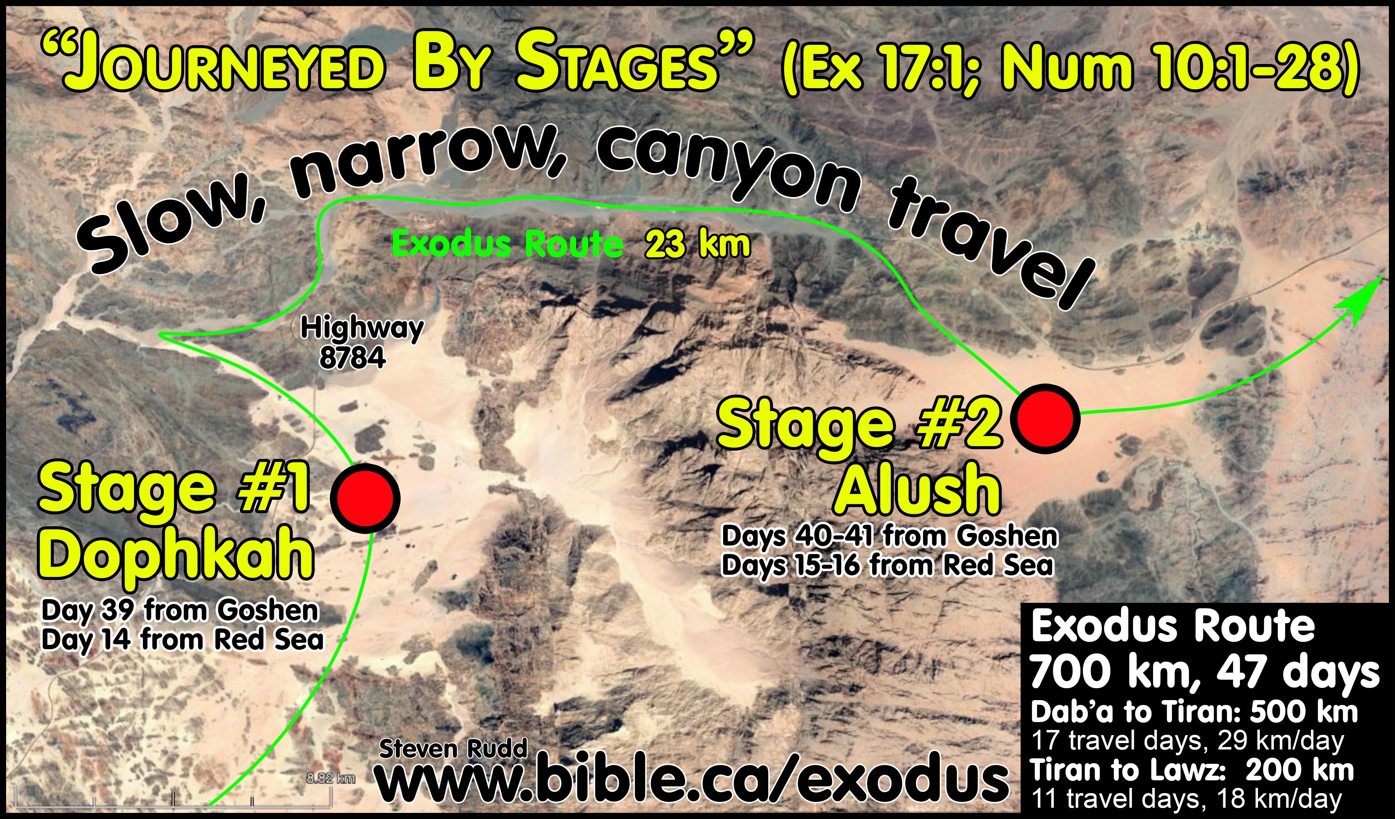
- "Then all the congregation of the sons of Israel journeyed by stages from the wilderness of Sin, according to the command of the Lord, and camped at Rephidim, and there was no water for the people to drink." Exodus 17:1
- "They journeyed from the wilderness of Sin and camped at Dophkah. They journeyed from Dophkah and camped at Alush." Numbers 33:12-13
- Another synchronism I discovered in my research on the exodus route is the fact that between the Wilderness of Sin and Rephidim (Meribah) they "journeyed in stages". Two legs of the journey took them from the Dophkah, to Alush and finally to Rephidim.
- This overlooked synchronism of "Journey in stages" though mountains and difficult terrain is actually a perfect fit for my proposed exodus route and is a disaster for most others.
- If you check my exodus route map, the 23 kms of canyon travel between Dophkah and Alush is the only time in the entire journey they passed through mountains AND therefore the narrative indicates they had to journey in stages of smaller groups, as opposed to moving as a mass group of 3 million.
i. See my exodus route for the stunning synchronism of geography, bible timing/distance after a Red Sea crossing at the Straits of Tiran)
ii. Little is known about Alush or Dophkah except that they are obviously located in difficult terrain that required moving in stages. Alush or Dophkah are both staging locations between the wilderness of Sin and Rephidim.
- Israel also travelled by stages when they left Mt. Sinai:
- The same word for stages [nāsa’ – Strongs 4550] in Ex 17:1 is also used in Num 10:12-16 when Israel clearly departed Sinai in stages of smaller groups rather than as one large group.
- “nāsaʿ is also used in the sense of to “journey by stages.” Headed for Sinai, the Israelites “moved on from the wilderness of Sin by stages” (pl. of massaʿ, Ex 17:1).
- Later they “set out by stages from the wilderness of Sinai” (Num 10:12).” (Theological Wordbook of the Old Testament, 1380 נָסַע, p584, Marvin R. Wilson, 1999 AD).
- This proves the word “stages” means smaller travel groups of the larger population in Ex 17:1.
- They had to travel in stages, because the entire population was unable to move together at the same time.
- So, Moses must have divided up the group and sent them "caravan style" in staggered groups.
- Another synchronism is that the Amalekites attacked when the first group completed the stages, exited the mountainous area and started on their way to Rephidim: Exodus 17:7-8
- It was a brilliant military move that the Amalekites attacked the first group, who was also short of water before the entire population arrived.
- Something so simple as "journeyed by stages" has been missed by everyone but it is a key to unlocking the exodus route. Any proposed route that cannot account for mountainous or difficult terrain during this section of the journey must be rejected.
|
Expected difficulty of Terrain of Exodus Route They Journeyed by stages between the Wilderness of Sin and Rephidim: Ex 17:1 |
||||
|
Route |
Terrain expected from Bible narrative |
Terrain encountered Steven Rudd1 |
Terrain encountered Gordon Frantz2 |
Terrain encountered Glen Fritz3 |
|
Goshen to Red Sea camp |
Easy |
Easy |
Easy |
Difficult and narrow before Nuweiba |
|
Red Sea camp to Wilderness of Sin |
Easy |
Easy |
Easy |
Difficult and narrow |
|
Difficult and narrow |
Difficult and narrow |
Easy |
Easy |
|
|
Difficult and narrow |
Difficult and narrow |
Easy |
Difficult and narrow |
|
|
Alush to Sinai |
Easy |
Easy |
Easy |
Easy |
|
Sinai to Kadesh |
Easy |
Easy |
Difficult via Ezion Geber |
Easy |
|
Assessment |
|
|
|
|
|
1: Rudd: Red sea crossing is at Tiran, Mt. Sinai is Lawz, Kadesh is at Petra. 2: Frantz: Red sea crossing is at Ballah, Mt. Sinai is Sin Bisher, Kadesh is at Qudeirat. 3: Fritz: Red sea crossing is at Nuweiba, Mt. Sinai is Lawz, Kadesh located inside Judah 32 km due west of Ein Hatzeva and 12 km SE of Sde Boker. |
||||
|
|
|
|
|
KEY#6 Edom's territory was Transjordan from 1446 - 605 BC This forces Kadesh Transjordan at Petra Most bible maps today wrongly locate Kadesh at Ein Qudeirat |
- Kadesh Barnea is located on the border of Edom and archeologically, it is rather simple to prove that Edom was Transjordan during the exodus in 1446 BC.
- Kadesh Barnea located at Petra is on the historic border of Edom!
- Kadesh Barnea located Ein Qudeirat is impossible because it is 80km west of the Transjordan border of Edom.
- Kadesh Barnea is located in both the Wildernesses of Paran and Zin.
- Edom never ventured out of her Transjordan territory until after the attack of Nebuchadnezzar in 605 BC as seen in the Arad Ostraca and Obadiah, Ps 137 etc.
- Joshua never encountered Edom during the conquest. In fact the only two times Edom is even mentioned in the book of Joshua is when Judea's territory "reached the border of Edom" (Josh 15:1,21
- The Arad ostraca document the first historic incursion of Edom into the territory of Judah after 605 BC
- Kadesh is on the border of Edom with a Transjordan location. Edom never ventured west of the Arabah valley into Judah/Simeon territory until after the first attack by Nebuchadnezzar 605 BC. Qudeirat as Kadesh Barnea is impossible because it is 80 km west of the border of Edom in 1446 BC.
- Learn more about Arad Ostraca .
- Learn more about the history
of Edom.
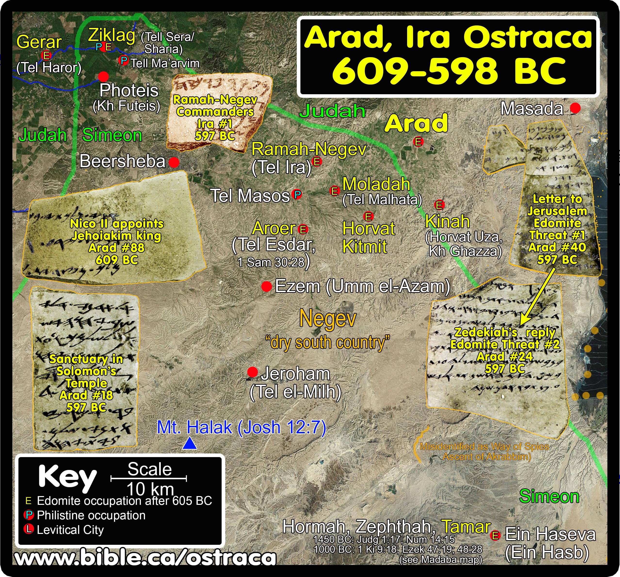
- The map below on the left is the archeologically and historically correct border of Edom: 1446-605 BC. The map on the right is the "Revisionists Map of Errors" all because they put Kadesh Barnea in the wrong place deep inside the Promised Land:
- Some archaeologists modify the record of the biblical text and archeology of the territory of Edom in a Finkelsteinly manner.
- These revisionists have shockingly moved Edom's Territory 80 km west inside the Promised Land at the time of the Exodus and conquest. Take note that Edom was not one of the nations Joshua fought.
- These fiction writers are not content with moving Edom's borders 80 km west, they also move southern border of Judah 100 km north, ignoring the fact that the Bible clearly defines the southern border of the promised land as the Wadi El-Arish or the River of Egypt (Gen 15:18).
- It is actually quite shocking that such an assault on the Bible is ignored by Bible students when they follow the opinions of archeologists who are hard pressed to reform truth to fit their false exodus route theory. Its time for churches to wake up!
- These revisionist fiction theorists ALSO move the Wilderness of Paran and Wilderness of Zin from their correct Transjordan location to INSIDE THE PROMISED LAND, when they are NEVER placed in the territory of Judah and Simeon in any scriptural narrative. Paran and Zin are clearly not inside Judean lands.
- All this rewriting history and redrawing ancient national boundaries is done TO KEEP KADESH BARNEA AT QUDEIRAT.
- Perhaps these revisionists might consider leaving truth alone and moving THEIR Kadesh Barnea at Qudeirat out of the promised land and back to its truthful Transjordan location at Petra.
|
Archeologically and historically correct border of Edom: 1926-550 BC
|
"Map of Errors" used by revisionists who locate Kadesh at Ein Qudeirat
|
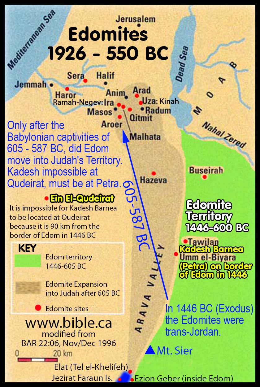
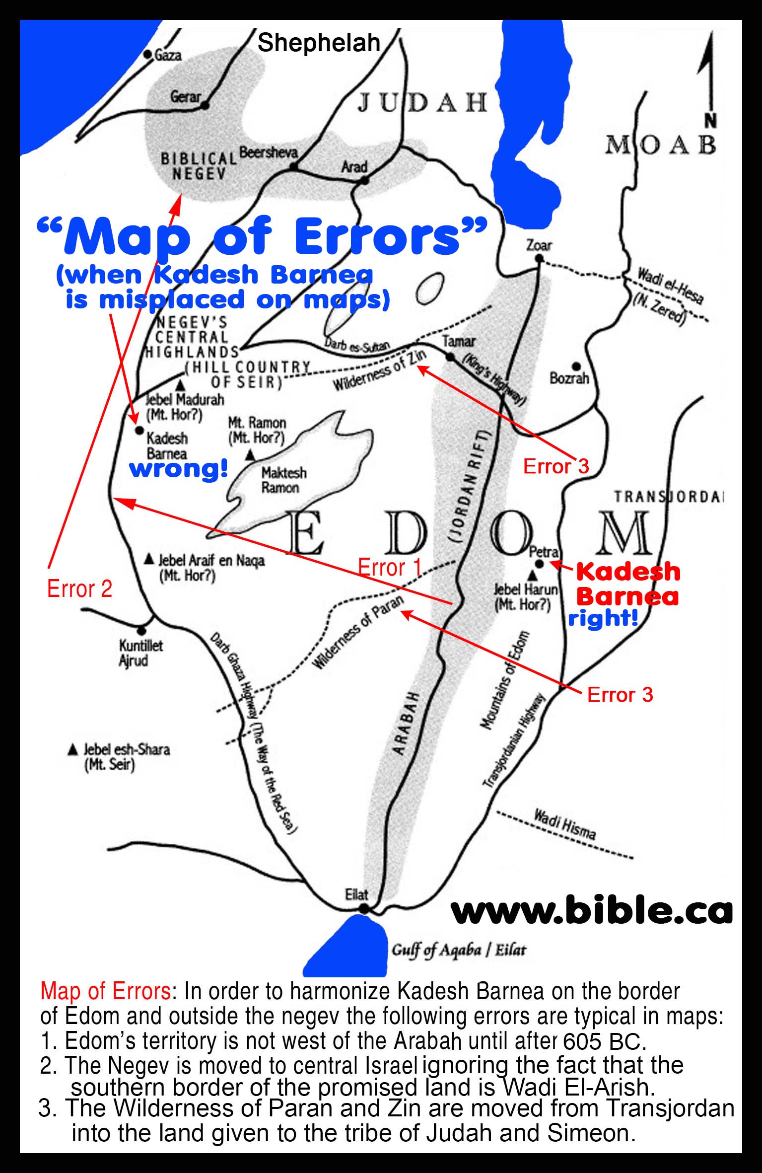
|
|
|
|
|
KEY#7 Sinai Peninsula is
Egyptian territory in 1446 BC |
- Moses was not "out of Egypt" until he was off the Sinai Peninsula.
- The eastern border of Egypt extended from the Nile to the port town of Arish on the Mediterranean Sea.
- The Eastern border itself was the River of Egypt (Wadi El-Arish) that started at the port city of Arish and followed the river south towards the Gulf of Aqaba.
- The Amarna letters came from all the port cities of Canaan including Gaza, but none from Arish because it was part of Egypt.
- What is important is that these letters record foreign city kings requesting the help of Egypt to defend against the conquests of Joshua.
- To have a record of Joshua's conquest written in cuneiform on clay tablets buried in the Egyptian city of Amarna, built by Akhenaten, that names the Hebrews is incredible The cuneiform consonantal translation of the invading enemy is "Habiru" or Hebrew!
- The 382 Amarna letters mention the Hebrews countless times as Joshua conquers the 7 nations of the promised land.
- The Amarna letters, therefore show that
Arish was inside Egyptian territory.
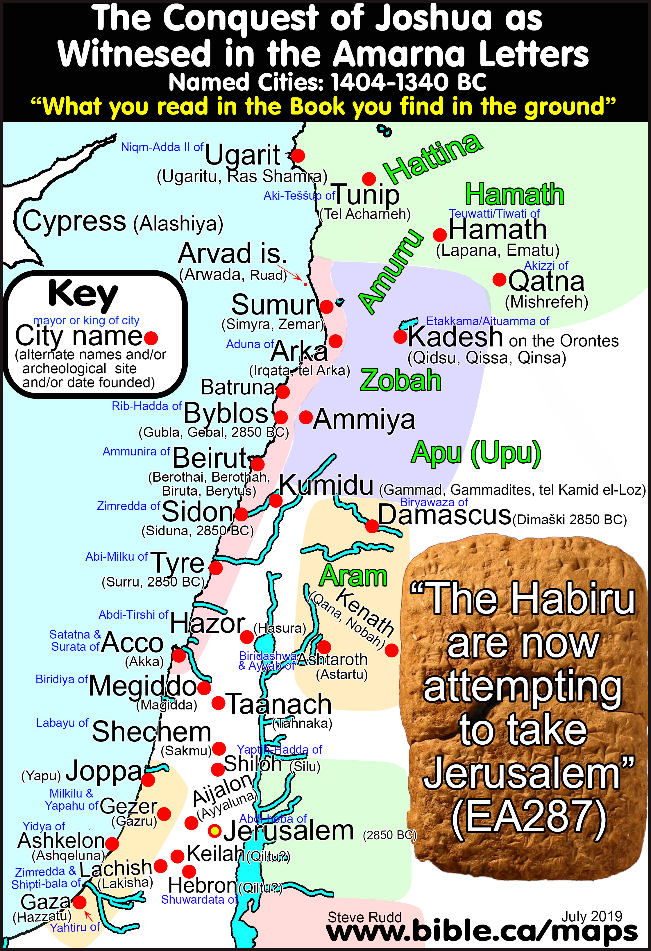
- Sinai Peninsula = Wilderness of Egypt:
- See Wilderness of Egypt
- Israel was not "out of Egypt" until they exited the Sinai Peninsula at the Straits of Tiran into the wilderness of Shur at Midian. (Saudi Arabia)
- "As I entered into judgment with your ancestors in the wilderness of the land of Egypt, so I will enter into judgment with you, says the Lord God." (Ezekiel 20:36)
- The judgement Ezekiel refers to is when God judged the entire nation of Egypt, as he is about to do to Jerusalem in 587 BC: "Then Moses and the Israelites sang this song to the Lord: “I will sing to the Lord, for he has triumphed gloriously; horse and rider he has thrown into the sea." (Exodus 15:1)
- The Amalekites lived near Mt. Sinai in north Saudi Arabia near Egypt, which can only be the Sinai Peninsula:
- "Now David and his men went up and raided the Geshurites and the Girzites and the Amalekites; for they were the inhabitants of the land from ancient times, as you come to Shur even as far as the land of Egypt." (1 Samuel 27:8)
- Shur would be near the city of Midian near the Straits of Tiran
- "as far as Egypt" can only be the Sinai Peninsula.
- Those who say Israel are "out of Egypt" on the east side of the Ballah, Timsah or Bitter lakes after crossing through them, ignore the historical fact that the port town of Arish (Tharu) was a state prison camp on the eastern border of Egypt:
- "the law be applied against him by cutting off his nose and sending him to Tharu." (Horemheb’s great edict, 108. Edict from Karnak, Texts from the Amarna Period in Egypt (Vol. 5). W. J. Murnane, E. S. Meltzer, p235, 1995 AD)
- After walking 40 km from Goshen and crossing the Red Sea at Lake Timsah are you then out of Egypt and safe?
- The prison camp at Arish/Tharu is over 160 km east of Lake Timsah. You can't make this stuff up!
- "I brought your fathers out of Egypt, and you came to the sea; and Egypt pursued your fathers with chariots and horsemen to the Red Sea." Joshua 24:6 and "And on that same day [the day they left Goshen] the Lord brought the sons of Israel out of the land of Egypt by their hosts." Exodus 12:51. The argument goes like this: Exodus 12:51 says that Israel was "out of Egypt" the moment they left Goshen. Therefore the Sinai Peninsula cannot be part of the land of Egypt. Further, Joshua 24:6 says that Israel was "out of the land of Egypt" when they stood at the shores of the Red Sea. Therefore they were out of Egypt the entire time they were at Mt. Musa (modern Mt. Sinai) which is in the middle of the Sinai Peninsula.
- It is just this kind of sloppy exegesis that creates the problems of restoring the exodus route.
- For those who say the Sinai Peninsula was not Egypt, we ask, "What country did the Sinai belong to?"
- Out of Egypt in this context simply means out of the populated areas.
- We use the same language today when we say we are leaving town to go home to the suburbs, yet you are still in New York or Houston or Los Angeles.
- But now let’s turn the argument of these etymological gymnasts back on themselves: Gordon Franz, does this means that before they reached Lake Timsah or the Bitter Lakes, Israel was OUT OF EGYPT?
- What proves the ridiculous proves nothing at all!
- They travelled through a wilderness IN A ROUNDABOUT WAY to reach the Red Sea but were still inside Egyptian controlled territory until after they crossed the Red Sea:
- "but when they came up from Egypt, Israel went through the wilderness to the Red Sea and came to Kadesh." (Judges 11:16)
- "So God led the people by the roundabout way of the wilderness toward the Red Sea. The Israelites went up out of the land of Egypt prepared for battle." (Exodus 13:18)
- "They set out from Succoth, and camped at Etham, which is on the [far] edge of the wilderness." (Numbers 33:6)
- Philo describes a long and difficult journey from Goshen to the Red Sea: "having accomplished together a long and desolate journey through the wilderness, destitute of any beaten road, at last arrived"
- The Red Sea crossing had to be far enough away from Goshen to justify their bitter complaints about being in the wilderness: Exodus 14:11-12
- "Our fathers in Egypt did not understand Your wonders; They did not remember Your abundant kindnesses, But rebelled by the sea, at the Red Sea." (Psalm 106:7)
- When Israel saw the Egyptian army getting ready to attack them: "Then they said to Moses, "Is it because there were no graves in Egypt that you have taken us away to die in the wilderness? Why have you dealt with us in this way, bringing us out of Egypt? "Is this not the word that we spoke to you in Egypt, saying, 'Leave us alone that we may serve the Egyptians'? For it would have been better for us to serve the Egyptians than to die in the wilderness."" Exodus 14:11-12
- This is where the suggested crossing point near the Bitter Lakes or the northern Suez becomes absurd because they were only 25 miles from their homes in Goshen. Also, the Bitter Lakes are fresh drinkable water. With their herds, they had no concerns of starving or dying of thirst.
- They would never complain, they would just walk home and sleep in their own beds by evening!
- After crossing the Red Sea, there had to be an absolute guarantee of security from Egypt.
- Israel rejoiced after crossing the Red Sea but if they had just crossed near the Bitter lakes THEY WOULD KEEP RUNNING. Three suggested crossing points must be wrong because they provided absolutely no security: 1. Bitter Lakes. 2. Lake Timsah. 3. Northern tip of Gulf of Suez. At these crossing points, the pillar of fire could not protect Israel, since Pharaoh's army would simply go around the lake from both sides and ambush them! Even with Pharaoh's army drowning, these crossing points are so close to Egypt, that a second army, though inferior to the first, could be sent by Pharaoh. The second army would attack Israel from all directions. Therefore, these crossings provide no peace of mind as all of them are inside Egypt.
- After crossing at the Gulf of Aqaba, they knew they were fully secure. Therefore, the only crossing point which would provide absolute security and peace of mind is the "Straits of Tiran" at the Gulf of Aqaba.
- Two Egyptian copper/turquoise mines were
in full operation in 1446 BC in the Sinai:

- The entire Sinai Peninsula is "IN
EGYPT" and has always been under Egyptian control. Two ancient
Egyptian controlled copper and turquoise mines at the time of the exodus
were located at Serabit el-Khadim and Timna. Another major Egyptian sea
port was located at Jezirat Faraun Island near modern Elat. Jezirat
Faraun cannot be Ezion Geber because it is not inside Edom.
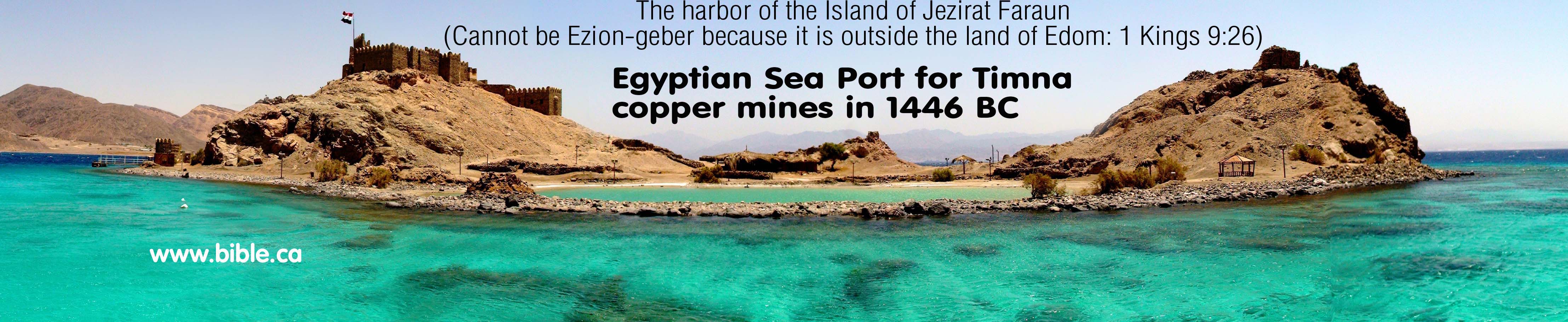
- Any Mt. Sinai located inside the modern "Sinai Peninsula" was not "out of Egypt".

|
|
|
|
|
KEY#8 The River of Egypt is the border between Egypt and Israel Wadi el-Arish = River of Egypt Arish = Tharu in 1446 BC and Rhinocolura [lit: cut off nose] in 100 BC |
A. THE BIBLE SAYS: West of the River of Egypt (Sinai Peninsula) has always been Egyptian territory
|
|
1. The Bible clearly defines the Sinai Peninsula as Egyptian territory since the border between Egypt and Israel has ALWAYS been the River of Egypt (Wadi el-Arish). Gen 15:18; Num 34:3-5; Deut 11:24; Josh 1:4; 15:1-4, 47; 1 Ki 4:21; 8:65; 2 Ki 24:7; 2 Chro 9:26; Isa 27:12-13; Ezek 47:19; 48:28
|
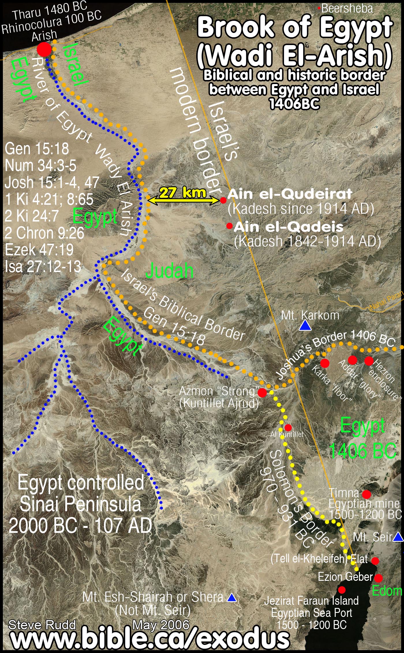
- The eastern border of Egypt WAS the river of Egypt (Wadi El-Arish)
|
Text |
Northern border |
Southern border |
|
Gen 15:18 |
as the great river, the river Euphrates |
from the river of Egypt |
|
1 Ki 8:65 |
from the entrance of Hamath |
to the brook of Egypt |
|
2 Ki 24:7 |
to the river Euphrates |
from the brook of Egypt |
|
2 Chr 7:8 |
from the entrance of Hamath |
to the brook of Egypt |
|
Isa 27:12 |
from the flowing stream of the Euphrates |
to the brook of Egypt |
|
2 Chr 9:26 |
from the Euphrates River |
as far as the border of Egypt |
|
1 King 4:21 |
from the River |
to the border of Egypt |
|
Jer 2:18 |
to drink the waters of the Euphrates |
to drink the waters of the Shihor?(see: Joshua 13:3) |
|
Ex 23:31 |
to the River Euphrates |
from the wilderness |
- Notice the interchangeability between brook of Egypt and border of Egypt!
|
Brook of Egypt |
Border of Egypt |
|
Euphrates to brook of Egypt: Gen 15:18 |
Euphrates to border of Egypt: 2 Chron 9:26 |
|
Solomon ruled to brook of Egypt: 1 Ki 8:65 |
Solomon ruled to border of Egypt: 1 Ki 4:21 |
- MOST BIBLE MAPS ARE WRONG: because they fail to recognize the River of Egypt as the border between Egypt and Israel
- MOUNT SINAI: Any Bible map that locates Mt. Sinai west of the River of Egypt is wrong because they were out of Egypt after crossing the Red Sea. Israel did not spend 11 months at Mt. Sinai still in Egypt.
- KADESH BARNEA: Almost every Bible map since 1916 AD wrongly places Kadesh 27 km east of the River of Egypt at Qudeirat which is inside territory of Judah/Simeon. Israel did not spent 38 years INSIDE the Promise Land at Kadesh (at Qudeirat).
- The border of Egypt has always been the Wadi el-Arish.
- Notice that Egypt proper ended at the Brook of Egypt: "The king of Egypt [Pharaoh Nico II] did not come out of his land again, for the king of Babylon Nebuchadnezzar had taken all that belonged to the king of Egypt from the brook of Egypt to the river Euphrates." 2 Kings 24:7
- So, you think the Sinai Peninsula was outside the control of Egypt? Answer this: What country or king controlled the "Sinai Peninsula" at the time of the Exodus?
- Their answer, if they can even think of one, is "I don't know" or "no one" or "it was a barren waste land nobody wanted" or "it was a caravan crossroads between nations" or "it is kind of like asking who owns the Atlantic Ocean: everyone and no one at the same time. The Sinai Peninsula was a kind of "desert ocean" no one controlled."
- Yet all these are wrong. Egypt has always controlled the Sinai just as we see today.
- Josephus specifically calls the Sinai Peninsula "Egypt":
- Time of Joshua: "the lot of Simeon bordered upon Egypt and Arabia." (Josephus, Antiquities 5.78)
- The only place Egypt can border Simeon is the Sinai Peninsula, thus proving the entire Sinai was part of Egypt both at the time of the Exodus and in the first century AD when Josephus lived.
- Arish was the eastern border town of Egypt where criminals with their noses cut off were sent at the time of Joshua.
|
|
ARISH PRISON CAMP: Nose cut off and exiled to the border The fact that Arish was an Egyptian prison town from the time of the Exodus down to Paul, is utterly devastating to those who say the Sinai was not Egypt proper. The port city of Arish was in fact the far eastern border of Egypt at the Wadi el-Arish. It always has been. Any Mt. Sinai located in the Sinai Peninsula is impossible because the entire Peninsula was "inside Egypt" and under Egyptian control. Only a Mt. Sinai in Arabia, on the other side of the Gulf of Aqaba is outside Egypt entirely. Detailed study of Rhinocolura. |
- The Wadi el-Arish flows into the Mediterranean Sea at Arish. Arish was called Tharu in 1446 BC and Rhinocolura [lit: cut off nose] in 100 BC.
- 1348-1320 BC: "my majesty commands: that every officer who seizes the dues and taketh the craft of any citizen of the army or of any person who is in the whole land, the law shall be executed against him, in that his nose shall be cut off, and he shall be sent to Tharu. (James Henry Breasted, Ancient Records of Egypt, 1906 AD, Vol 3 p 50-67, The Great Edict of Pharaoh Horemheb, 1300 BC)
- Against Requisitioning Boats Used for State Corvee Duty: "If a private individual makes for himself a boat with its on-board shelter, in order to be able to serve Pharaoh, l.p.h., and if people] of the army [come and appropriate it as if it were for (?)] taxes: then the individual is despoiled of his property and deprived of his abundant means [of doing service. This is a crime!] Something like this should not be done [to controvert] his good purposes. As for every boat which is taxable for the offering halls of Pharaoh, l.p.h., by the two deputies [of the army] …, [if someone comes] and seizes a boat belonging to any member of the army or anybody in the entire land, let the law be applied to him by cutting off his nose and sending him to Tcharu {Tharu}. [As for] an individual who is without a boat, and he gets from someone else a boat for his service obligation, and undertakes on his own to bring wood and is thus fulfilling his obligations [to Pharaoh, l.p.h., …]: [should others] seize and plunder his cargo, and steal it, and the individual stands despoiled of his [means of doing service … so that] he has nothing—This is not good, this report: it is an abuse indeed! My Person had decreed that one should turn away from it. Indeed, [this applies to …, and to] those who contribute to the Private Quarters, and similarly to all the gods’ offerings when they are taxed by the two deputies of the army and …: [if anyone does this, let] the law [be applied] against him by cutting off his nose and sending him to Tcharu {Tharu}." (Horemheld’s great edict, 108. Edict from Karnak, Texts from the Amarna Period in Egypt (Vol. 5). W. J. Murnane, , E. S. Meltz, p235, 1995 AD)
- 15 AD: "Next to Gaza is Raphia, where a battle was fought between Ptolemy the Fourth and Antiochus the Great. [218 BC] Then Rhinocolura, so called because the noses of the colonists had been mutilated. Some Ethiopian invaded Egypt, and, instead of putting the malefactors to death, cut off their noses, and settled them at Rhinocolura, supposing that they would not venture to return to their own country, on account of the disgraceful condition of their faces." (Strabo, Geogr. 16.2.31, reporting event in 218 BC)
- Notice that Strabo reports even in 15 AD, that it was the Egyptians who settled the criminals. This fact proves the Sinai Peninsula was under Egyptian control both during the Exodus and IN THE MIND OF PAUL.
- In addition to Arish/Rhinocolura and the Bible "slapping us silly in the face till we get it" with 13 verses that the Sinai Peninsula was Egyptian territory with the River of Egypt as the eastern border of Egypt, Josephus actually proves the Sinai Peninsula is not part of Arabia:
- "However, our admirable author Apion hath before told us, that “they came to Judea in six days’ time;” and again, that “Moses went up to a mountain that LAY BETWEEN EGYPT AND ARABIA, which was called Sinai, and was concealed there forty days, and that when he came down from thence he gave laws to the Jews.” (Against Apion 2.24)
- Josephus is clearly refuting both the timing and location of Mt. Sinai in the Sinai Peninsula by "fiction writer Apion".
- So Queen Helina was not the first person to wrongly place Mt. Sinai inside Egyptian territory (Sinai Peninsula) in 325 AD, Apion gets the prize for this deception.
- Josephus identifies Apion as the first person in history to misplace Mt. Sinai in the Sinai Peninsula as fiction he invented.
- Read the quote again and suddenly it all becomes clear! Josephus knew Sinai was located in Saudi Arabia but Apion, known for his deliberate corruption of details of the Exodus, moved it into the Sinai Peninsula outside of Arabia.
- Solomon built a series of
fortresses near the Egyptian border just east of the Wadi el-Arish in the
Negev to protect his Kingdom.
B. ANCIENT SOURCES set the border of Egypt at Wadi El-Arish and Arish/Tharu/Rhinocolura.
1. 1457 BC: Tuthmosis III in the Battle of Megiddo
a. "Year 22, fourth month of the second season, on the twenty-fifth day his majesty was in Tharu on the first victorious expedition to extend the boundaries of Egypt with might. Now, at that period the Asiatics had fallen into disagreement, each man fighting against his neighbor. Now, it happened that the tribes - the people, who were there in the city of Sharuhen; behold, from Yeraza to the marshes of the earth, they had begun to revolt against his majesty. Year 23, first month of the third season, on the fourth day, the day of the feast of the king's coronation, he arrived at the city, the possession of the ruler, Gaza." (An Egyptian Account of The Battle of Megiddo by Pharoah Menkheperre, Tuthmosis III, 1457 BC)
2. 1273 BC: Ramses II in the Battle of Kadesh
a. In 1273 AD, Ramses II marched by the fortress of Tharu in full splendor of his father Montu en route to begin the battle of Kadesh against the Hittites. Tharu, at this time, was an Egyptian fort and historically it was the border of Egypt. It proves that Egypt had control right up to the Wadi el-Arish.
b. "Behold, his majesty prepared his infantry and his chariotry, the Sherden of the captivity of his majesty from the victories of his word - they gave the plan of battle. His majesty proceeded northward, his infantry and his chariotry being with him. He began the goodly way to march. Year 5, the second month of the third season tenth month, on the ninth day, his majesty passed the fortress of Tharu, like Montu [his father] when he goes forth. Every country trembled before him, fear was in their hearts; all the rebels came bowing down for fear of the fame of his majesty, when his army came upon the narrow road, being like one who is upon the highway." (James Henry Breasted, Ancient Records of Egypt, 1906 AD, Vol 3 p 136-147, The Battle of Kadesh, Ramses II, 1273 BC)
3. 250 BC: The Septuagint (LXX):
a. The Septuagint substitutes "the brook of Egypt" in Isa 27:12 for Rhinocolura.
b. This shows that everyone knew that the River of Egypt in Gen 15:18 was the same as Rhinocorura and ancient Tharu at the time of the exodus in 1446 BC.
c. "In that day the Lord will start His threshing from the flowing stream of the Euphrates to the Rhinocolura (LXX), and you will be gathered up one by one, O sons of Israel. " Isaiah 27:12 (LXX)
4. 150 BC: Polybius:
a. Ptolemy was marching from Egypt to Rhinocolura to Raphia to Gaza. Rhinocolura (Tharu) was the border of Egypt for it says, Raphia was the first city you reach after leaving Egypt. Of course today, Raphia is the Modern border between Egypt and Israel.
b. "Ptolemy, marching on Pelusium, made his first halt at that city, and after picking up stragglers and serving out rations to his men moved on marching through the desert and skirting Mount Casius and the marshes called Barathra. Reaching the spot he was bound for on the fifth day he encamped at a distance of fifty stades from Raphia, which is the first city of Coele-Syria on the Egyptian side after Rhinocolura. Antiochus was approaching at the same time with his army, and after reaching Gaza and resting his forces there, continued to advance slowly. Passing Raphia he encamped by night at a distance of ten stades from the enemy. At first the two armies continued to remain at this distance from each other, but after a few days Antiochus, with the object of finding a more suitable position for his camp and at the same time wishing of encourage his troops, encamped so near Ptolemy that the distance between the two camps was not more than five stades. Skirmishes were now frequent between the watering and foraging parties, and there was occasional interchange of missiles between the cavalry and even the infantry." (Polybius, The Histories 5:80, 150 BC)
5. AD 70: Josephus:
a. Josephus gave two separate accounts of how Herod the Great escaped from the king of Arabia, into Egypt about 25 BC. Notice that as Herod traveled along the shoreline from Israel to Egypt, he stopped at an Egyptian Temple, that was very near Rhinocurura. This proves that as late as 25 BC Rhinocurura was the border between Egypt and Israel.
b. "Hereupon he [Herod the Great] resolved to go away, and did go very prudently the road to Egypt; and then it was that he lodged in a certain temple; for he had left a great many of his followers there. On the next day he came to Rhinocolura, and there it was that he heard what had befallen his brother. (Josephus, Antiquities 14.374, 25 BC)
c. "So when Herod had found that the Arabians were his enemies, and this for those very reasons whence he hoped they would have been the most friendly, and had given them such an answer as his passion suggested, he returned back and went for Egypt. Now he lodged the first evening at one of the temples of that country, in order to meet with those whom he left behind; but on the next day word was brought him, as he was going to Rhinocurura, that his brother was dead, and how he came by his death; and when he had lamented him as much as his present circumstances could bear, he soon laid aside such cares, and proceeded on his journey." (Josephus, Wars 1.277, 25 BC)
- Josephus records the line of cities in sequential order from Gaza, in Israel towards Egypt. Notice the order is Joppa, Jamnia, Ashdod, Gaza, Anthedon, Raphia, and Rhinocolura. Rhinocolura being the ancient border between Egypt and Israel as stated in Gen 15:18 to Abraham. (River of Egypt or wadi-el-Arish) "Now at this time the Jews were in possession of the following cities that had belonged to the Syrians, and Idumeans, and Phoenicians: At the seaside, Strato's Tower, Apollonia, Joppa, Jamnia, Ashdod, Gaza, Anthedon, Raphia, and Rhinocolura." (Josephus, Antiquities 13.395)
- Josephus, at the time of Titus's destruction of Jerusalem in 70 AD, says that the border between Egypt and Israel (actually Syria at this time) was at Rhinocolura. Josephus said that Raphia was the first town within "Syria". Raphia is the modern border town today between Israel and Egypt. What this means is that the modern boundaries between Egypt and Israel closely match the ancient boundaries. "So Titus marched on foot as far as Nicopolis, which is distant twenty furlongs from Alexandria; there he put his army on board some long ships, and sailed upon the river along the Mendesian Nomus, as far as the city Thmuis; there he got out of the ships, and walked on foot, and lodged all night at a small city called Tanis. His second station was Heracleopolis, and his third Pelusium; he then refreshed his army at that place for two days; and on the third passed over the mouths of the Nile at Pelusium; he then proceeded one station over the desert, and pitched his camp at the temple of the Casian Jupiter, and on the next day at Ostracine. This station had no water; but the people of the country make use of water brought from other places. After this he rested at Rhinocolura, and from thence he went Raphia, which was his fourth station. This city is the beginning of Syria. For his fifth station, he pitched his camp at Gaza; after which he came to Ascalon, and thence to Jamnia, and after that to Joppa, and form Joppa to Cesarea, having taken a resolution to gather all his other forces together at that place." (Josephus, Wars 4.659, 70 AD)
- "The lot of Simeon (inside Judah), which was the second, included that part of Idumea [Edom] which bordered upon Egypt and Arabia." (Josephus, Antiquities 5.82) In Joshua 19:1-9 Hormah is listed as one of the cities of Simeon. Hormah may have been located at Ein Haseva in 1446 BC.
6. AD 325: The Onomasticon by Eusebius
- Eusebius wrote a book called the Onomasticon in about 325 AD.
- The Onomasticon is a dictionary of places, towns and countries. It is an ancient atlas.
- The Madaba map (600 AD, see below) was based in part upon the Onomasticon.
- "Bethaphu (Jos 15:53), in the tribe of Judah. A village near Raphia, on the 14th milestone on the road to Egypt, which marks the boundary of Palestine." (Eusebius, Onomasticon 50,18-20; Jerome 51,18-19)
- Eusebius says the actual border between Israel and Egypt was just west of Raphia. Since we know that the town of Tharu (Rhinocolura) was under Egyptian control, this is exactly what we expect and fits perfectly with where the border was located.
7. AD 400: Jerome:
- Jerome says the border of Egypt bordered on Raphia. This is east of the Wadi el-Arish.
- Raphia is where the modern border of Israel is located.
- "In a battle near the town of Raphia, which is on the borders of Egypt, Antiochus lost his entire army and was almost captured while escaping through the desert. He retreated from Syria, and eventually the war was concluded with a treaty on certain conditions." (Jerome, Daniel 11:10-14, 400 AD)
8. AD 542: Madaba Map:
- The "Madaba map" is a mosaic floor laid in AD 542. It is in St. George's Orthodox church in the city of Madaba, Jordan. The map is famous because it is one of the oldest maps of Bible lands in the world. It agrees with the "Onomasticon" (dictionary of cities) written by Eusebius in AD 325.
- The proof doesn't get much better than this! An actual in situ mosaic we can visit by jumping on an airplane today and see for ourselves with our own eyes!
- It is a mosaic that confirms that the Wadi el-Arish is the border between Israel and Egypt.
- The Madaba map has the words in Greek
“Horoi Aigyptou kai Paleaistines” which translates to "Border of
Egypt and Palestine". Notice the border is between the towns of
Bitylium and Rhinocolura.
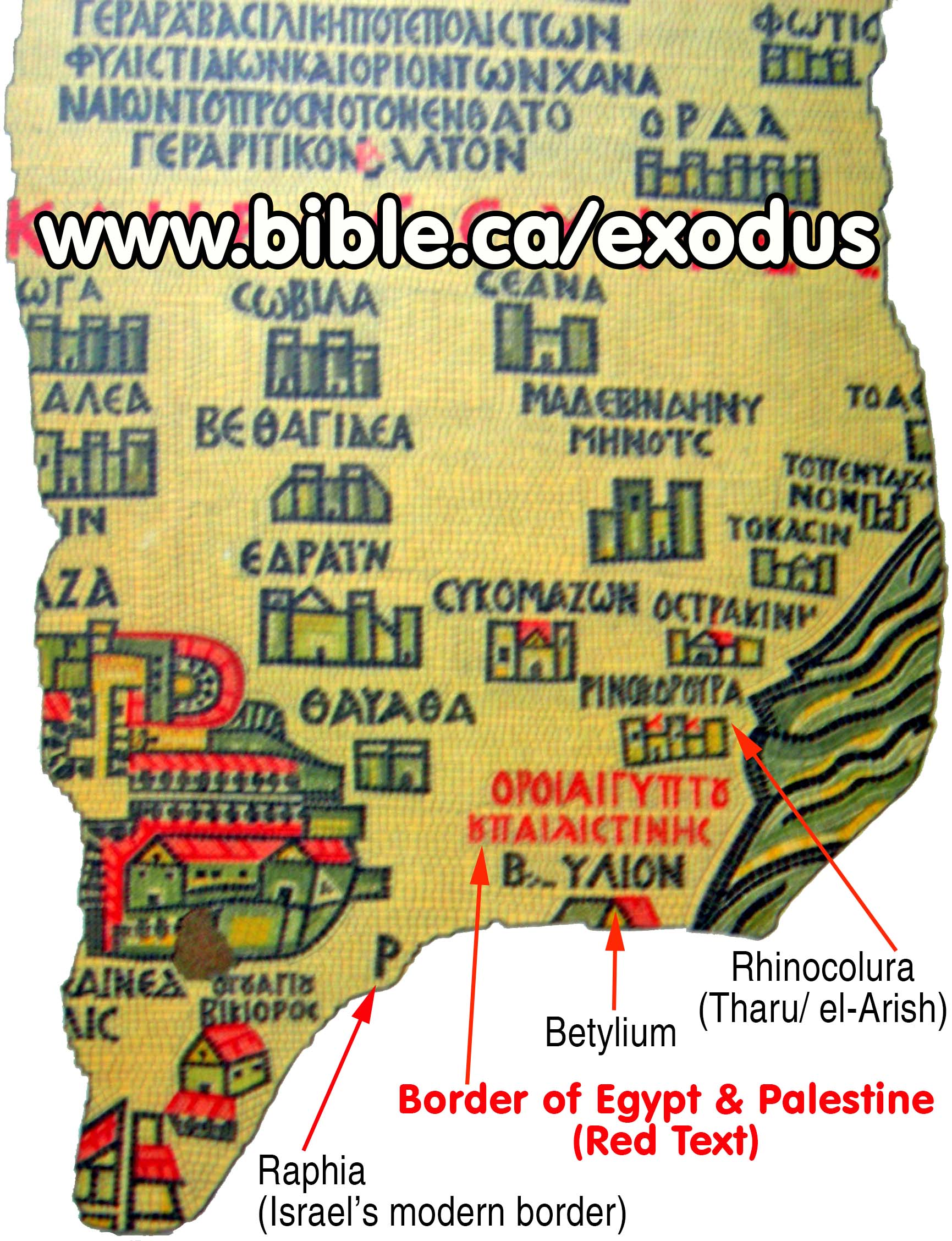
Conclusion:
- Fiction writers say that the Sinai Peninsula was not Egyptian Territory.
- Both the Bible and all ancient sources say that Egypt's border ended at the port city of Arish and the River of Egypt also known as the Wadi El-Arish.
- Only a sloppy, careless disregard of the inspired scriptures and all history would cause someone to ignore the fact that the River of Egypt has always been the border between Egypt and Israel.
- In light of such megalithic evidence from scripture and ancient sources, those who continue to say that the Sinai Peninsula was NOT Egyptian territory are myopic.
|
|
|
|
|
KEY#9 The Ezion-Geber enigma "It is eleven days’ journey from Horeb by the way of Mount Seir [Edom via Ezion-Geber] to Kadesh Barnea." (Deuteronomy 1:2) |
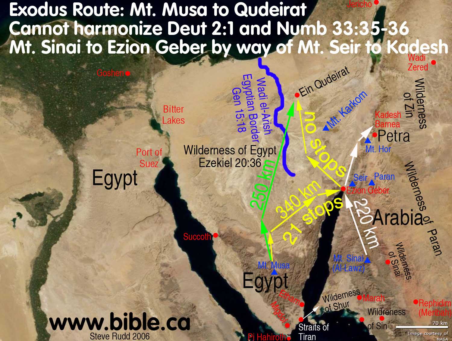
- The Ezion-Geber enigma is any exodus route map that does not pass through Ezion-Geber as the last of 22 stops between Sinai and Kadesh Barnea. (Num 33:36)
- Ezion Geber is a critical location many overlook in their exodus route maps.
- Any exodus route map that does not pass directly through Ezion-Geber is flat wrong.
- Ezion-Geber was a sea port town on the north end of the Gulf of Aqaba in the land of Edom:
- "Then Solomon went to Ezion-geber and to Eloth on the seashore in the land of Edom." (2 Chronicles 8:17)
- "King Solomon also built a fleet of ships in Ezion-geber, which is near Eloth on the shore of the Red Sea, in the land of Edom." (1 Kings 9:26)
- Since Jezirat Faraun was an Egyptian sea port to facilitate mining at Timna, Ezion-Geber must be located on the Arabian (eastern) side of the northern tip of the Red Sea in the land of Edom.
- Ezion-geber was inside Edom and Kadesh was on the border with Edom. Edom never ventured out of her Transjordan territory until after the attack of Nebuchadnezzar in 605 BC as seen in the Arad Ostraca and Obadiah, Ps 137 etc. Transjordan Edom is 100 km east of Qudeirat whereas Petra is another perfect fit as it is on the eastern border of Edom just as the Bible says.
- "It is eleven days’ journey from Horeb by the way of Mount Seir to Kadesh Barnea." (Deuteronomy 1:2)
- The 11-day route between Mt. Sinai at Lawz in Saudi Arabia via Edom (Mt. Seir) through Ezion-Geber to Kadesh Barnea at Petra is a perfect fit.
- Mt. Seir means they passed by the capital city of Transjordan Edom at Mt. Seir.
- “The Lord came from Sinai, And dawned on
them from Seir; He shone forth from Mount Paran, And He came from the
midst of ten thousand holy ones; At His right hand there was flashing
lightning for them." (Deuteronomy 33:2) Here is the best candidate for
Mt. Paran in the middle of the wilderness of Paran in historic Edomite
territory.
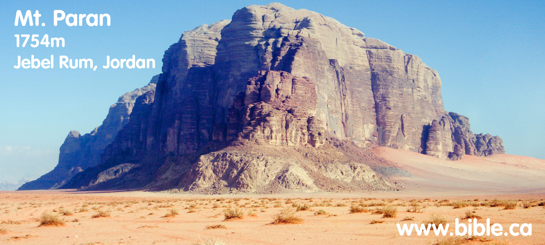
- Ezion-geber supports a Kadesh located at Petra and makes Kadesh Barnea in most Bible maps at Ein Qudeirat impossible for these reasons:
- There is an almost impassable mountain range between Ezion-Geber (near Elat) and Ein Qudeirat. I have driven the modern road between Elat and Qudeirat many times and the route is impossible for a large population.
- Ezion-Geber was the LAST of 22 stops between Sinai and Kadesh but is geographically at the halfway point if Kadesh is Ein Qudeirat. The idea that 135 km journey (as the bird flies) from Ezion-Geber to Ein Qudeirat is ONE STOP through the mountains is impossible to harmonize.
- On the other hand, the Arabah Valley
Between Ezion-geber and Petra is a flat wide, easy downhill walk through
a 5 km wide flat valley.
- Many Exodus Routes that suffer from the Ezion-geber Enigma!
- Gordon Franz's Sinai at Mt. Sin Bisher is absurd since Ezion-geber is the last stop before a Kadesh at Qudeirat. Indeed, Franz totally ignores Ezion-Geber on his exodus route map.
- Even if he did have the route between "his Sinai" and "Woolley/Lawrence's Kadesh" at Qudeirat, pass through Ezion-Geber, the Israelites would have to traverse a huge mountain range not once BUT TWICE.
- Even worse is a mount Sinai at Gebel Khashm et-Tarif (Hashem el-Tarif)
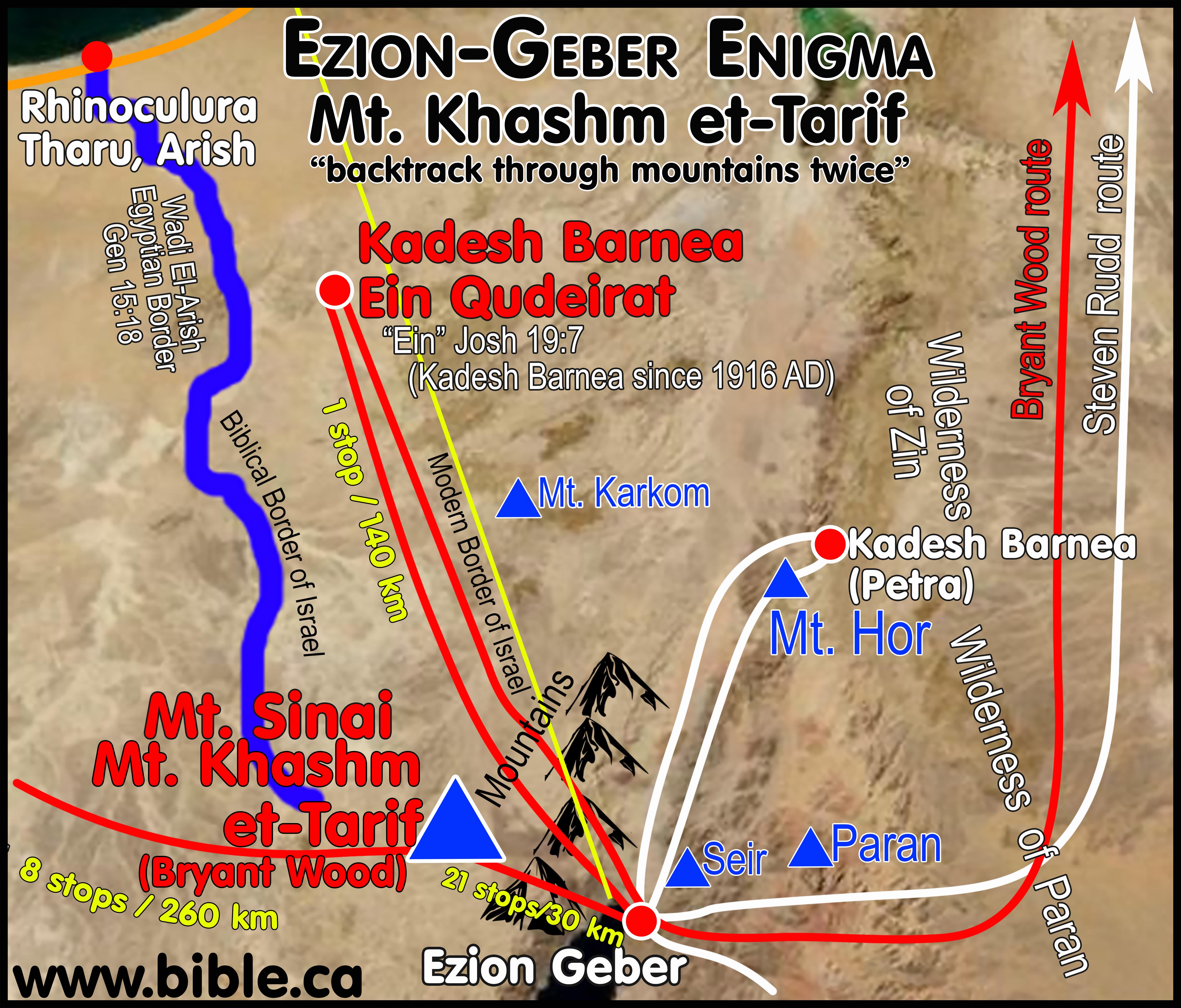
- Israel would travel 40 km to go 3 stops from Tel el dab'a to Lake Timsah
- Then travel 260 km to go 8 stops between Lake Timsah and Gebel Khashm et-Tarif
- What is worse, is now you travel 30 km to go 21 stops between Gebel Khashm et-Tarif and Ezion-geber.
- What is worse still, is that this is the opposite direction if you are heading for Kadesh at Qudeirat. If Kadesh is your destination Ezion-geber is the wrong way.
- But worse again is that the trip is through an impassible mountain range as high as the Canadian Rockies!
- Then after reaching the "dead end" at Ezion-geber you must "pull an Etham" and turn around and backtrack, and retrace your steps through these impassible mountains a second time.
- Worse still is that you then go directly past Mt. Sinai at Gebel Khashm et-Tarif.
- But it gets worse because while it took you 21 stops to get from Mt. Sinai to Ezion-geber, now you only have 1 stop to get from Ezion-geber passing by Mt. Sinai at Gebel Khashm et-Tarif and then head north to travel 110 km.
- After spending 38 years at Kadesh (Qudeirat) the Israelites would need to retrace their path a third time through the mountains past Ezion-geber and then start heading north to Dibon, Mt. Nebo and Shittim to cross the Jordon.
- This is a good example of the Ezion-geber Enigma and why most ignore the problem altogether by creating exodus routes that ignore this critical stop.
- Check your exodus route map to see if the last stop before Kadesh passes directly past the north end of the Gulf of Aqaba at Ezion-Geber. If it does not, its wrong!
|
|
|
|
|
KEY#10 The southern border of Judah puts Kadesh Barnea at Petra "The border of Judah goes up to the south of Kadesh" Numbers 34:3-5; Joshua 15:1-4; Ezekiel 47:19; 48:28 |
A. The Bible says Kadesh is Transjordan near Petra
See: detailed study of the southern border of Judah
- The Bible makes it crystal clear that Kadesh is Transjordan near Petra by simply tracing the southern and eastern border of Judah. Here are the two texts:
- "‘Your southern sector shall extend from the wilderness of Zin along the side of Edom, and your southern border shall extend from the end of the Salt Sea eastward. ‘Then your border shall turn direction from the south to the ascent of Akrabbim and continue to Zin, and its termination shall be to the south of Kadesh-barnea; and it shall reach Hazaraddar and continue to Azmon. ‘The border shall turn direction from Azmon to the brook of Egypt, and its termination shall be at the sea." (Numbers 34:3-5)
- "Now the lot for the tribe of the sons of Judah according to their families reached the border of Edom, southward to the wilderness of Zin at the extreme south. Their south border was from the lower end of the Salt Sea, from the bay that turns to the south. Then it proceeded southward to the ascent of Akrabbim and continued to Zin, then went up by the south of Kadesh-barnea and continued to Hezron, and went up to Addar and turned about to Karka. It continued to Azmon and proceeded to the brook of Egypt, and the border ended at the sea. This shall be your south border." (Joshua 15:1-4)
- "The south side toward the south shall extend from Tamar as far as the waters of Meribath-kadesh, to the brook of Egypt and to the Great Sea. This is the south side toward the south." (Ezekiel 47:19)
- "And adjoining the territory of Gad to the south, the boundary shall run from Tamar to the waters of Meribah-kadesh, from there along the Brook of Egypt to the Great Sea." (Ezekiel 48:28)
- Kadesh Barnea, the assent of Akrabbim and the Wilderness of Zin are all OUTSIDE THE PROMISED LAND AND THE LAND OF JUDAH.
- ROAD TRIP! Imagine you are in a car driving on the Bible border of Judah.
- You start driving at Engedi and follow the western shoreline of the Salt Sea.
- When you reach the end of the Salt Sea, turn left (East) and start driving towards modern Jordan. Those who wrongly place Kadesh at ein el-Qudeirat must head WESTWARD, not Eastward. They go 180 degrees the wrong direction and head in a straight line through the assent of Akrabbim (wrongly located at Ma'ale Aqrabim on the west side of the Arabah valley), and continue in a straight line through the middle of Judah's territory (which they wrongly call the Wilderness of Zin) and then to complete their comedy of errors, on to ein el-Qudeirat as their choice for Kadesh.
- But if you drive eastward, as the Bible says, you reach the real "assent of Akrabbim", turn right and drive due south towards the Gulf of Aqaba.
- Next you pass the Wilderness of Zin on your left (in modern Jordan), but you never actually enter the Wilderness of Zin.
- Then, as you keep driving due south, you pass Kadesh Barnea (at Petra) again on your left. THIS IS THE ONLY WAY KADESH REMAINS OUTSIDE THE BOUNDARY OF THE PROMISED LAND as the Bible says.
- After you pass the sign on the road that says, "Kadesh due East on your left" you keep driving SOUTH OF KADESH. A few miles south of Kadesh is where the north/south portion of the border "terminates".
- The border continues "as far as Kadesh" (which is at Petra outside the land of Judah) then changes direction due west, and starts heading for the Brook of Egypt.
- So as you drive past Kadesh on your left, only then do you make a 90 degree turn to the right and start driving due west towards the River of Egypt.
- In this way the border "went up south of Kadesh". Placing Kadesh Barnea at ein el-Qudeirat simply cannot harmonize any of these details.
- Only when Kadesh is located somewhere
Transjordan between the Dead Sea and the Red Sea on the eastern side of
the Arabah valley, do these details fit perfectly!
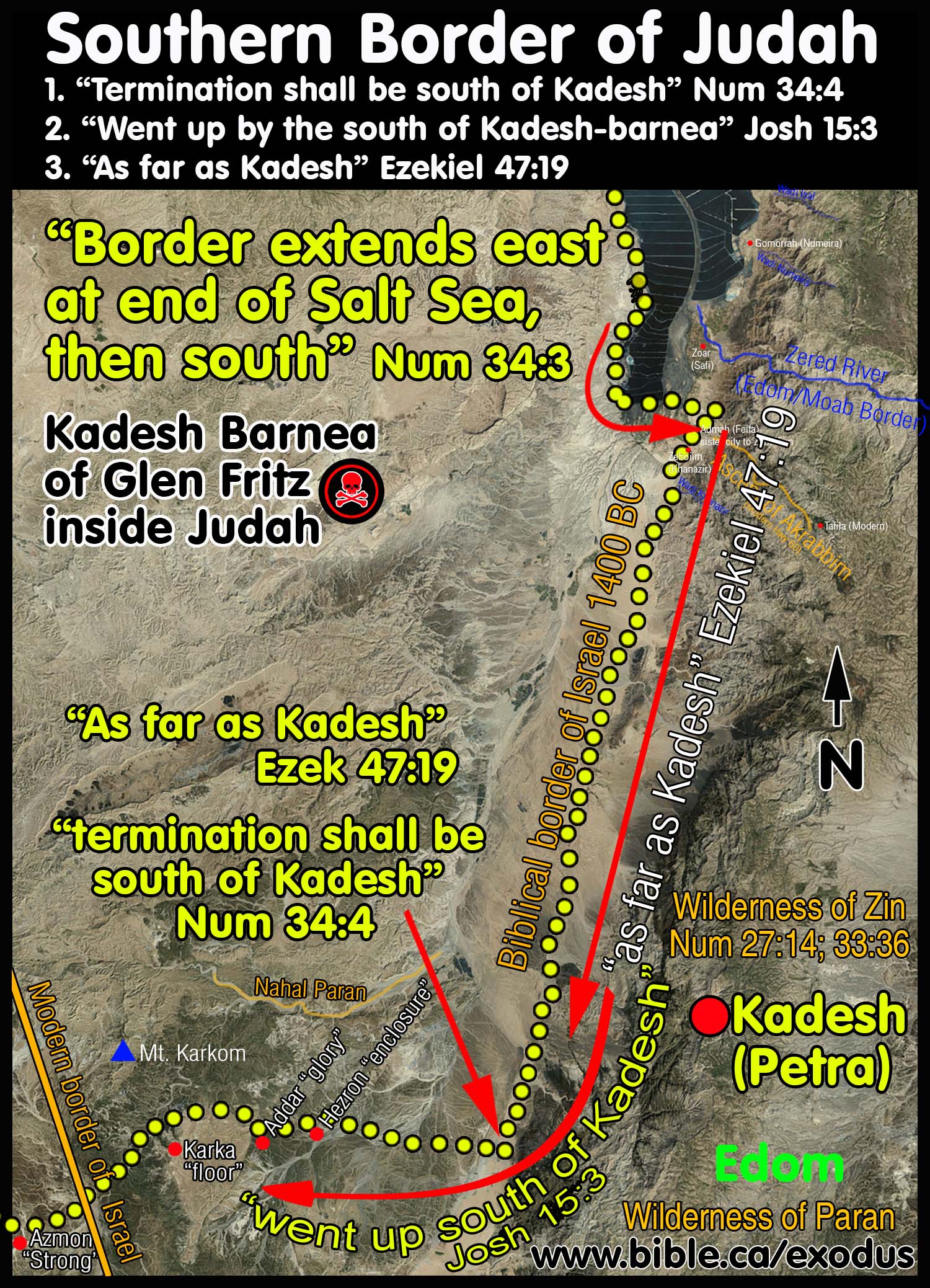
B. We can prove Kadesh is Transjordan from the Bible, when you understand this illustration:
- Illustration: Texas is the promised land and Tampa is north of Brownsville.
- False conclusion: If Tampa is north of Brownsville it is in Texas.
- Truth: Tampa is not in Texas but is located both north of Brownsville and outside the state of Texas.
- Conclusion: Tampa is in Florida and outside the promised land of Texas!
- Application: Judah is the promised land and Kadesh Barnea is north of the southern border of Judah.
- False conclusion: If Kadesh is north of the southern border of Judah it is inside the promised land at Qudeirat.
- Truth: Kadesh is not in Judah but is located both north of the southern border of Judah and outside the promised land.
- Conclusion: Kadesh Barnea is located at Petra and cannot be located at
Qudeirat.
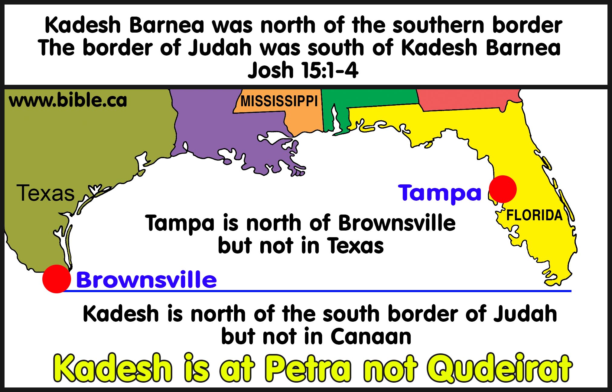
- Compare this map of Judah with the illustration above:
- Qudeirat is north of the southern border of Judah but inside the promised land given to Judah by 27 km.
- Petra is north of the southern border of
Judah but NOT inside the promised land given to Judah.
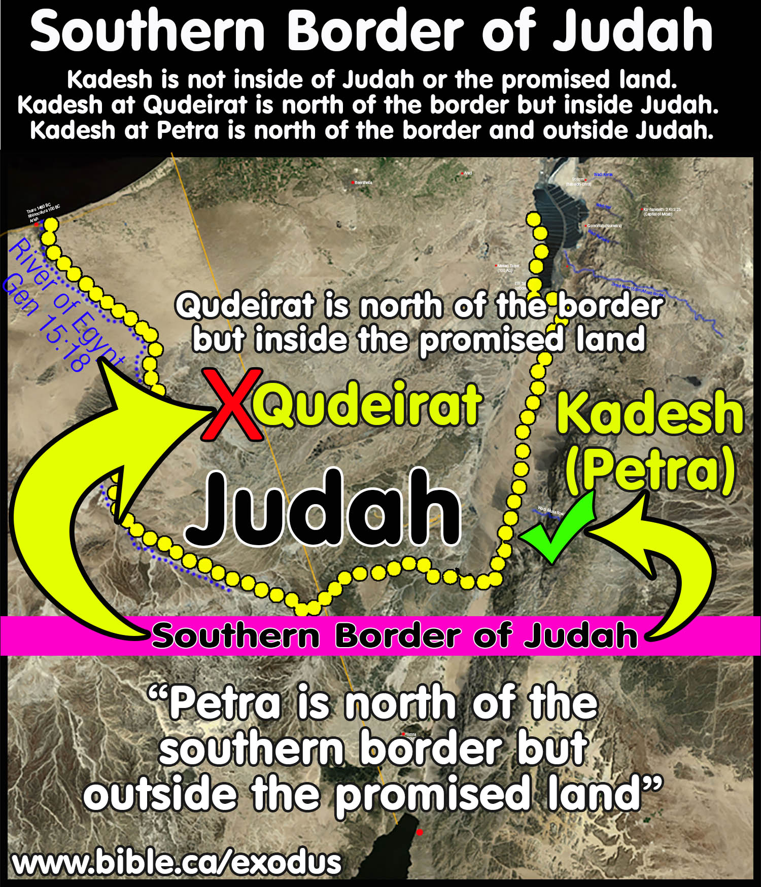
Conclusion:
- Failure to trace the southern border of Judah is why every Bible map is wrong when it places Kadesh inside the promise land at Qudeirat.
- A simple reading of Numbers 34:3-5; Joshua 15:1-4 will show that "The border of Judah goes up to the south of Kadesh", means that Kadesh is at Petra.
- Kadesh is at Petra not Qudeirat and every Bible map in the world is wrong.
- See: detailed study of the southern border of Judah
|
|
|
|
|
KEY#11 "Piltdown Kadesh" vs. Biblical Kadesh Barnea at Petra Israel did not spend 38 years inside the promised land at Ein Qudeirat Most modern Bible maps put Kadesh Barnea in the wrong place |
Indiana Jones: "Balloq's medallion only had writing on one side? You sure about that?" Sallah: "Positive!" Indiana: "Balloq's staff is too long. Indiana." Both: "They're digging in the wrong place!"
"For 100 years they have been digging for Kadesh in the wrong place"
Detailed study of the history of the search for Kadesh Barnea.
Kadesh Barnea at Petra and the "Piltdown Kadesh" on all our modern Bible maps at Ein Qudeirat
- Piltdown man was a deliberate hoax that deceived the world for 40 years that evolution was a fact.
- In 1912, Arthur Woodward announced to the world that he had found the missing link between ape and man. Piltdown Man, as he called it, consisted of a jaw bone and a piece of skull which he estimated to be over 500,000 years old!
- However, in 1953, when the new fluoride dating process was applied to the bones, scientists were shocked to learn that the jaw bone was less than 50 years old. Only then did they notice that the bones and teeth had been treated with salts and filed to make them appear old and primitive.
- In other words, Piltdown Man was a complete fraud. Take note Bible student! The world's foremost scientific experts had been fooled for over 40 years! (Read 1 Corinthians 3:18-20.)
- For almost a half century, evolutionists pushed Piltdown Man in the faces of Bible believers as scientific proof that man evolved from apes! Some proof!
- In spite of over 100 years of intensive searching, the only place you will find a missing link today is in the colourful imagination of an evolutionist. Museums certainly don't have any!
- "In the beginning God created the heavens and the earth." (Gen 1:1)
- Have you ever considered that when God created the universe in six short 24 hour days, He may have been taking His time?
- PILTDOWN KADESH: The 100 year fraud Christians still believe!
- For 100 years a deliberate fraud by Henry Clay Trumbull deceived the world with his lying account of Ein el Qedeis which moved Kadesh Barnea from Petra to inside the promised land. Until Trumbull came along, everyone was looking for Kadesh Barnea Transjordan at Petra or in the Arabah valley that runs from the Salt Sea to the Gulf of Aqaba.
- For details of Trumbull deception, see introduction.
- Since 1916 AD all Bible maps wrongly place Kadesh Barnea at Ein Qudeirat after Woolley/Lawrence chose that location after rejecting nearby Ein el Qedeis once the lies of Trumbull we exposed.
- It is impossible for Ein Qudeirat to be Kadesh, since it is 27 km deep inside the promised land.
- Edom and the Negev are such a problem to those who want Ein Qudeirat to be Kadesh, that they move Edom to inside Judah and the Negev north of Beersheba. (see above)
- As the largest oasis in the Sinai Peninsula, Joshua identifies Ein Qudeirat as "Ain" not Kadesh: Joshua 19:7; 1 Chron 4:32 as part of Simeon's Territory.
- The location of Kadesh must satisfy these facts:
- PETRA = ROCK = Moses brought water from a rock at Kadesh: The Nabatean name "Petra", actually traces its origin back to the time when Moses brought water from the rock at Kadesh. There is an ancient tradition that dates back to Josephus that the Siq at Petra is the river of Moses from the Exodus. Josephus also names one of the springs at Petra, at the top of the Siq "Ain Musa" or “Spring of Moses”. Both of these names are in use today among the Arab population. In the Late Bronze age of the Exodus (1446 BC) the name of Petra was Kadesh Barnea, but it was called Sela (ie. rock), during the monarchy (1000 BC).
- Kadesh is a burial city because 2-3 million Hebrews died at Kadesh (Num 14:29-35). The modern Nabatean city (300 BC-69 AD) was one big necropolis (Burial city). This tradition likely traces back to the exodus while they lived 38 years at Petra between 1444-1407 BC.
- Kadesh is Transjordan, southeast of the salt sea. (Numbers 34:3-5; Joshua 15:1-4)
- Kadesh Barnea was on the border of Edom: Num 20:16. Archeology has proven the fact that Edom was historically Transjordan (east of the Arabah) until they first moved into Judean territory after the Babylonian captivity that began in 605 BC. This means that before 605 BC Edom's territory was always Transjordan. Ein el Qudeirat is nowhere near the border of Edom, which disqualifies it as Kadesh. Modern Bible maps make a grave error of locating Edom well into the Negev, not because of archeological evidence, but because they know the border of Edom was beside Kadesh.
- In a spectacular display of circular reasoning these maps bring the border of Edom right beside Ein el Qudeirat, where they wrongly believe Kadesh is located. Kadesh Barnea, wilderness of Paran and Wilderness of Zin must be outside all boundaries of Israel and outside the Negev. No Bible passage says that Kadesh Barnea, Paran or Zin were ever part of Israel territory or located in the Negev, or on the western edge of the Arabah.
- Kadesh is near Mt.
Hor, the burial place of Aaron. This photo take from an altar on the
summit of a mountain at Petra looking east to Mt. Hor where Aaron was
buried.
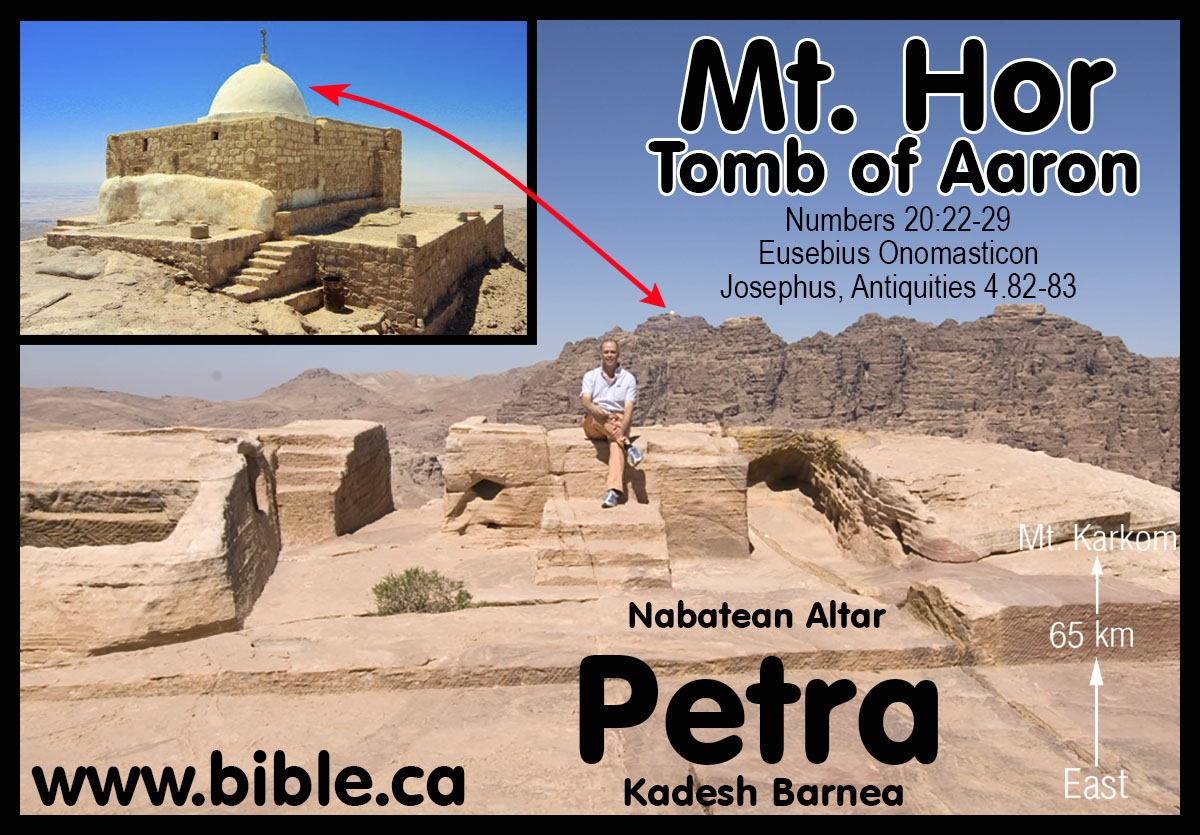
4. Ancient sources who located Kadesh Barnea at Petra:
- Josephus stated that the burial place of Aaron was at Petra. "Then it was that Miriam, the sister of Moses, came to her end, having completed her fortieth year since she left Egypt, on the first day of the lunar month Xanthicus. They then made a public funeral for her, at a great expense. She was buried upon a certain mountain, which they call Sin; and when they had mourned for her thirty days ... Now when this purification, which their leader made upon the mourning for his sister, as it has been now described, was over, he caused the army to remove and to march through the wilderness and through Arabia; and when he came to a place which the Arabians esteem their metropolis, which was formerly called Arce, but has now the name of Petra, at this place, which was encompassed with high mountains, Aaron went up one of them in the sight of the whole army, Moses having before told him that he was to die, for this place was over against them." (Josephus, Antiquities 4.82-83)
- In 325 AD Eusebius (and Jerome in 400 AD) wrote the Onomasticon, which is a "dictionary of places" and locate Kadesh at Petra:
- At Petra, the 1 km long Siq that the water was channeled down is called, the "wadi of Moses" according to ancient tradition. The Onomasticon says that in AD 325, you could still see the rock that Moses struck at Kadesh and the tomb of Aaron at Petra.
- Eusebius writes: "Kadesh Barnea (or Cades Barnea): "Kadea Barne. The desert which extends to (the city of) Petra a city of Arabia. There Mariam went up and died, and there the doubting Moses struck the rock to give water to the thirsty people. The tomb of Mariam herself is pointed out there even now. There also Chodollagomor beat the chiefs of the Amalakites." (Eusebius, Onomasticon, round brackets are Eusebius') Footnote #: 580. Kadēa Barnē. Numbers 32:8; K. 112:8; L. 270:4. Textual variant city of Palestinē (Greek) instead of Arabia. This reflects again the uncertainty of editorial additions and of the use of Arabia in the Onomasticon (K. 110:27). Latin combines K. 112:7 and K. 112:8. Some confusion in order of this and the next three entries. A summary of biblical information from Numbers 21:1, 11; Numbers 27:14 and Genesis 14:7. A tomb tradition is here. No location is given other than near Petra (K. 142:7). Procopius repeats the entry in 332D and 1021D. It also is reaffirmed by Jerome in Commentary on Ezekiel 38:23(cf. K. 46:26). In Interpretation of Hebrew Names "Cades, holy or change" (63); "Cades, alteration or holy" (80); "Cadesbarne, selected change or changeableness" (80). (The Onomasticon, Eusebius, 325AD)
- Eusebius writes: "Mt Hor: ōr. Mountain on which Aaron died near the city of Petra. There is now pointed out the rock which flowed for Moses (which Moses struck and gave water to the people)." Footnote #: 979. ōr. Numbers 20:22, 28; K. 176:7; L. 291:88. Mt. near Petra (K. 142:7). Cf. K. 126:19 and K. 46:14 for Aaron's death. See K. 150:23 for Mt. Seir. Josephus Antiquities IV, 4, 7 tells of Aaron's death up on the mountain range that encloses Petra. In Interpretation of Hebrew Names "Or, passionate" (77) and "Or, light" (83). (The Onomasticon, Eusebius, 325AD)
- Eusebius writes: "Kadēs. Where the spring "of judgment" was. Footnote #: 579. Kadēs. Genesis 14:7; K. 112:7; L. 269:3. Simple biblical notation. In Hebrew Questions Jerome says "Cades is a place near Petra called the spring of judgment where God judged the people". (The Onomasticon, Eusebius, 325AD)
- Eusebius writes: "Beroth. "Of the sons of Jakeim (Iacim)." Place in the desert where Aaron died. It is pointed out (still today) ten miles from Petra on the summit of the mountain." (The Onomasticon, Eusebius, 325AD)
- Eusebius writes: "Barnea (same as Kadesh Barnea): "Barne: This is Cades Barne, on the desert which extends up to the city of Petra." (Eusebius, Onomasticon, round brackets are Eusebius') Footnote #: 213. Barnē. Joshua 10:41; K. 46:26; L. 247:74. Identified with the desert stretching south of Petra (K. 142:7) and more frequently Kadēs Barnē (K. 112:8). (The Onomasticon, Eusebius, 325AD)
- Eusebius writes: "Petra. City in the land of Edom in Arabia which is called Iechthoel. This is also called Rekem by the Assyrians (Syrians). Footnote #: 762. Petra. Judges 1:36; K. 142:7; L. 279:71. No letter division in the Vatican Greek manuscript here. Procopius 1048B has Petra in Idumala (K. 102:23). On Tabula Peutinger it is 48 miles south of Theman (K. 96:18). It is an important reference for the Onomasticon and all the Roman road systems. It is also called Rekem (K. 144:7 and K. 36:13). Mt. Hor (K. 176:7) is nearby. The Nabatean influence lasted into the Roman period of the Onomasticon. Petra was one of the Nabatean cities given autonomy about 106 A.D. with the establishment of the Roman Province of Arabia. It was a great city in the 3rd and 4th centuries. The Christians of Petra were persecuted by Diocletian. (The Onomasticon, Eusebius, 325AD)
- Eusebius writes: "Rekem. It is also Petra, city of Arabia, "whose ruler Rocom the children of Israel killed. It is said he was also king of Madiam." Footnote #: 773. Rekem. Numbers 31:8; K. 144:7; L. 280:94. Identity and summary of biblical information (Joshua 13:21; Numbers 31:8; cf. K. 142:7 and K.36:13, for Petra, named Rekim by Josephus). In Interpretation of Hebrew Names "Recem, variety or painting". (The Onomasticon, Eusebius, 325AD)
- Notice that Eusebius sees two different Cades, but the true Cades (or Kadesh Barnea) is next to the wilderness of Paran, also known as the desert of the Saracens: "Gerara. The Geraritike is now called after this, (the region) beyond the Daroma. Twenty-five miles south of Eleutheropolis. It is the old southern boundary of the Chanaanites and a royal city of the Philistines (metropolis of Palestine). It is located, as Scripture affirms, "between Cades and Sur" (i.e., between) two deserts. The one adjoins Egypt whence the people came having come through the (straits of the) Red Sea. The other (true) Cades extends up to the desert of the Saracens." (The Onomasticon, Eusebius, 325AD) Of course the Bible does not say that Gerar is between Kadesh Barnea and Shur, but that Abraham lived there, then moved and sojourned near Gerar. Eusebius and the Madaba map correctly place Gerar, but confuse its position in relation to Kadesh and Shur. Even today people misread Gen 20:2 the same way Eusebius did.
- Eusebius writes: "Asasan Thamar (Asasonthamar). Where the Amorrites dwelled whom Chodollagomor destroyed is located near the wilderness of Cades. It is said there is a village Tharmara (a fort Thamara) one day journey from Mapsis on the road from Hebron to Ailam. [Elat on the Red Sea, see Ailam] Today there is a garrison (Roman fort) of soldiers there." Footnote #: 8: Asasan Thamar (Asasonthamar). Genesis 14:7; K. 8:6; L. 234:84. On the Madaba Map there is a Thamara located as suggested by Eusebius here. Tabula Peutinger has a Thamaro 52 or 53 miles from Jerusalem while Ptolemy's list (V, 15, 5f) has a Thamaro about 55 miles distant. The Notitia Dignitatum (74:40) has a Tarba and (74:46) a Thamarra both of which have a garrison. Alt found a fort at Qasr el Juheiniye and he is followed by many locating the fort there and the village at 'ain el 'Arus. Aharoni more recently (TEJ, 1963, p.30ff) suggests 'Ain Husb which is about a day's walk (32 km) from Kurnub which is generally identified with Mapsis (cf. also Avi-Yonah) and has a large Roman fort as well as Nabatean and Iron II sherds. The Madaba Map using Jerome's spelling has located properly Mampsis. Many Nabatean, Roman-Byzantine levels excavated at Kuroub. It shows a revival in the fourth century A.D. as also does Oboda (Avdat, 'Abda, and K. 176:9).This may be indicated by "village" in Greek and "oppidum" in Latin (cf. K. 10:25). II Chronicles 20:2 identified Thamar with En Gedi or at least locates it in the district of En Gedi (86:16). Jerome in Hebrew Questions says, "his city which we now call Engaddi, is rich in balsam and palms since Asason Thamar translated into our language is city of the palms'" (18) (cf. Judges 1:16). (The Onomasticon, Eusebius, 325AD)
- Eusebius writes: "Ailam (Ailath). Is situated at the extremity of Palestine between the southern desert and the Red Sea where cargo was transported by ship from both Egypt and India. A detachment of the Tenth Roman Legion is stationed there. Properly called Aila today (it was formerly pronounced Ailath) from whence the ancient people the Ailamites whose king was Chodollagomor [who is mentioned in the Acts of the Apostles]. Another Ailam of the foreigners (of Palestine) is noted in Kings." Footnote #: 6: Ailam (Ailath). Genesis 14:1; K.6:17; L. 234:75. In the Vulgate we find Ailath, Elath, and Aila for this same site. Palestine is the southern part of Syria. This word is missing in the Vatican Manuscript. Technically the southern limits of the Onomasticon should be Ailam (Ailath). The ruins are inland about one mile from Aqabah but not as far inland as Tell el Kbeleifah which is probably the older Ezion Geber (K. 36:l, cf. K. 34:23, 62:13, Josephus Antiquities, IX, 12, 1). It was the end of the road going north to Damascus and the terminus of the overland road west to the Mediterranean. In Jerome's time it was a very busy port (Vita Hilariaris, 18, and cf. Commentary on Ezekiel 47:18). Eusebius does not indicate its size but it may be inferred that it was a polis. A bishop was present at Nicea. Eusebius uses some army source and the text is useful for noting the deployment of the Roman legion. The Tenth is located here. The Notitia Dignitatum (73:18f.) verifies this entry. The Tabula Peutinger, 820 has a Haila 83 miles from Petra and 150 miles southeast of Gaza which fits this site at el 'aqaba. The city in II Samuel 10:16 is in northeast Transjordan. The Syriac text notes it is a city of the Philistines. The Greek allophulos usually means Philistines but once or twice we cannot be positive, so in this present translation the general term "foreigners" has been preferred, especially when Jerome does not have Filistine. He has Filistine in K. 7:15, K. 21:2, K. 3:25, K. 119:3 but more often uses transliteration allofylorum (see Appendix I). (The Onomasticon, Eusebius, 325AD)
- The Onomasticon references two "Kades": One near Gerar but the "true Cades" at Petra. Eusebius places Arad near the Desert of Kadesh Barnea, but the Madaba map places Arad between Beersheba and Egypt rather than between Beersheba and the Dead sea. However the Madaba map is not to scale and has huge distortions of distance and relative size. "Arad. City of the Amorrites near the desert of Cades. There is now (shown) a village four miles from Malaatha, and twenty from Hebron. Tribe of Juda." (The Onomasticon, Eusebius, 325AD)
- 400 AD: Jerome: En-mishpat, Kadesh, Spring of Judgement is at Petra: Gen 14:7
- "Gen 14:7: And they returned and came to the fountain of judgement, that is, to Cades. Because Cades was so named later on, it is specificied by way of anticipation; and it refers to a place near Petra, which is called 'The Fountain of Judgement', because God judged the people there" (Saint Jerome's Hebrew Questions on Genesis, translated by C. T. R. Hayward, p 46, Gen 14:7, 1995 AD)
- "Kadēs. Where the spring "of judgment" was. Footnote #: 579. Kadēs. Genesis 14:7; K. 112:7; L. 269:3. Simple biblical notation. In Hebrew Questions Jerome says "Cades is a place near Petra called the spring of judgment where God judged the people". (The Onomasticon, Eusebius, 325AD)
- "No location [for Kadesh Barnea] is given other than near Petra (K. 142:7). Procopius repeats the entry in 332D and 1021D. It also is reaffirmed by Jerome in Commentary on Ezekiel 38:23(cf. K. 46:26). In Interpretation of Hebrew Names "Cades, holy or change" (63); "Cades, alteration or holy" (80); "Cadesbarne, selected change or changeableness" (80). (The Onomasticon, Eusebius, 325AD)
5. Modern sources who locate Kadesh Barnea is located at Petra:
a. 1856 AD Arthur Penrhyn Stanley:
- "It is moreover one of the few facts localised by anything like an authentic tradition,-in this case preserved by Josephus, the Talmudists, Eusebius, and Jerome, --that Kadesh was either identical, or closely connected with Petra." (Sinai and Palestine, in connection with their history, Arthur Penrhyn Stanley, 1856 AD, p84-99)
- "It [Mt Hor at Petra] is one of the very few spots connected with the wanderings of the Israelites, which admits of no reasonable doubt." ... "If there be any ground for this conclusion, Petra assumes a new interest. Its rock-hewn caves may have served in part for the dwellings, in part for the graves of the Israelites ; it is dignified as the closing scene of the life both of Miriam and Aaron". ... Is it too much to suppose that this point and Mount Hor were long regarded as the two sacred spots-of Petra ; that the scene of the death and sepulture of Aaron was designedly fixed in view of this, the innermost sanctuary of the Holy Place of " Kadesh ; " that this sanctity was retained through the successive changes of Pagan and Christian worship; and that the pilgrims of the Desert mounted these time-worn steps, and traced their inscriptions upon the rock, on their way to the only spot, whence they could see the grave of Aaron?" (Sinai and Palestine, in connection with their history, Arthur Penrhyn Stanley, 1856 AD, p84-99) Note: In 1901 AD, Robinson comments on Stanley, who said Kadesh was at Petra: "Stanley in his Sinai and Palestine (pp. 92-8) identifies Sela' or Petra with Kadesh, which is absurd." (Modern Kadesh or Ein Kadis, George L. Robinson, The Biblical World, Vol. 17, No. 5., May, 1901 AD) Of course, there is nothing absurd about Petra being Kadesh. Stanley's ill informed belief that the city carved in stone we see today, like the "Treasury" dates back to the Exodus is indeed absurd! Stanley was wrong to suggest that Petra as we see it today, is the result of the Hebrews in 1446 BC when in fact the city we see today was carved by the Nabataeans in 350 BC. But Stanley was right in correctly locating Kadesh at Petra. He was a lone voice of truth, who needed the help of modern archeology to make the correct conclusions we are making today almost 150 years later.
b. In 1891 AD Keil & Delitzsch state they are certain that Mt. Hor is located at Petra. In a most puzzling confusion, Keil & Delitzsch located Kadesh at Ein Qedeis, but located Mt. Hor 100 km east of Qedeis, at Petra. Both Kadesh and Mt. Hor were on the border of Edom and Mt. Hor was only "one stop" from Kadesh: Numbers 20:22; 33:37. This makes it impossible for Kadesh to be located 100 km west of Mt. Hor at Qedeis. The border of Edom cannot be both the Arabah valley AND at Ein Qedeis! Keil & Delitzsch write: "Death of Aaron at Mount Hor. - The Israelites left Kadesh [which Keil & Delitzsch believed was at Ein Qedeis], and passed along the road just mentioned to Mount Hor. This mountain, which was situated, according to Num. 33:37, on the border of the land of Edom, is placed by Josephus (Ant. iv. 4, 7) in the neighbourhood of Petra; so also by Eusebius and Jerome: "Or mons, in quo mortuus est Aaron, juxta civitatem Petram." According to modern travellers, it is Mount Harun, on the north-western side of Wady Musa (Petra), which is described by Robinson (vol. ii. p. 508) as "a cone irregularly truncated, having three ragged points or peaks, of which that upon the north-east is the highest, and has upon it the Muhammedan Wely, or tomb of Aaron," from which the mountain has received its name "Harun," i.e., Aaron (vid., Burckhardt, Syr. pp. 715, 716; v. Schubert, Reise, ii. pp. 419ff.; Ritter, Erdkunde, xiv. pp. 1127ff.). There can be no doubt as to the general correctness of this tradition; for even if the Mohammedan tradition concerning Aaron's grave is not well accredited, the situation of this mountain is in perfect harmony with the statement in v. 23 and Num. 33:37, viz., that the Israelites had then reached the border of the land of Edom." (Keil & Delitzsch, 1867, Num. 20:22-29)
c. In 1871 AD, Jamieson, Fausset, Brown give Petra as one of two locations on the Arabah Valley for Kadesh: "they came ... to Kadesh—an important encampment of the Israelites. But its exact situation is not definitely known, nor is it determined whether it is the same or a different place from Kadesh-barnea. It is supposed to be identical with Ain-el-Weibeh, a famous spring on the eastern side of the desert [Robinson], or also with Petra [Stanley]. (Jamieson, Fausset, Brown, 1871 AD, Num 13:26)
d. In 1908 AD: "Yet ever since Dean Stanley in 1856 (Sinai and Palestine, pp. 152, 153, 161) identified Jebel Nebi Haroun with Mt. Hor, and Petra with Kadesh-Barnea, most commentators have adopted without question his conclusion. (The True Mount Hor, Jebel Maderah. George L. Robinson, The Biblical World, Vol. 31, No. 2., Feb., 1908, p 86-100)
e. In 1910 AD, Nathan Schmidt, after considering Weibeh, Kades and Qudeirat, rejected them all and concluded that Kadesh was in fact at Petra: In choosing the location of Kadesh, Schmidt rejected Qudeirat in favor of Petra in 1910 the same way that Stanley rejected Weibah in favor of Petra in 1856: "It seems to me even more probable that Petra was the original scene of these stories. Here the great Deliverer (Cp. my article "The Jerahmeel Theory and the Historic Importance of the Negeb," Hibbert Journal, vi. 2 January, 1908, pp 339ff.) performed the miracle of piercing the rock and sending the wonderful stream through the Sik, and here his older brother Aaron died on the peak of Mt. Hor. In earlier times the gulf of 'Akabah reached farther north than it does today [note: Schmidt is wrong about water levels. Solomon's fortress at Elat -Tell el-kheleifeh was built on a hill 500 meters from the shore of the Red Sea less than 12 feet above current sea level. This proves sea levels have not changed much in 3000 years.], and a passage from the eastern side over to El Tih may not have been as easy as it is at present. Nomadic tribes pushing northwest from the land of Midian no doubt found their way down into the Negeb through the defiles of Mt. Seir (Jebel Sharra). The Idumaean clans that camped around Moserah and Zin probably brought with them the traditions of their heroes. Their way from Sinai-Horeb to Kadesh Barnea and Mt. Halak is likely to have led them through the Valley of Moses and put the reputed resting place of Aaron in Petra." (Kadesh Barnea, Nathan Schmidt, Journal of Biblical Literature, Vol 29, no 1, 1910 AD, p75-76)
6. The most ancient written sources unanimously located Kadesh Barnea at Nabatean Petra.
- The southern border of Judah places Kadesh near Petra.
- All ancient sources place Kadesh at Petra.
- This all changed when a deceiver named Trumbull fabricated a false story about finding a "New England meadow" at Ein Kades which led to its present misidentification on every map in the back of YOUR Bible since 1916 AD.
|
|
|
|
|
KEY#12 Carsten Niebuhr discovers the Gulf of Aqaba in 1762 AD Without the Gulf of Aqaba, the Sinai Peninsula becomes Arabia |
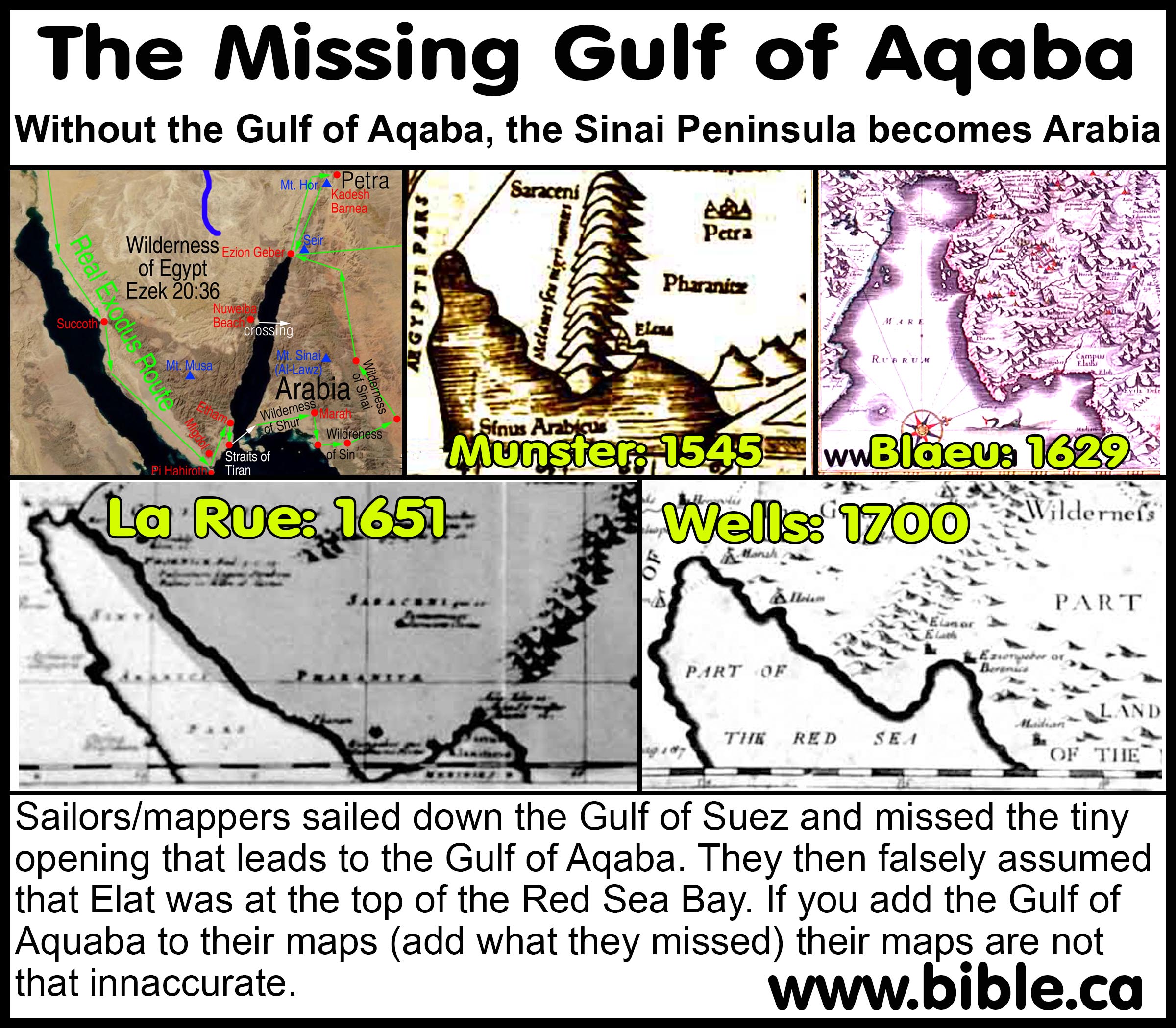
Step aside Christopher Columbus, Carsten Niebuhr discovers the Gulf of Aqaba in 1762 AD
- The Gulf of Aqaba was unknown to many ancient geographers and renaissance Exodus route maps ~1600 AD
- Without the Gulf of Aqaba, Arabia begins in the Sinai Peninsula and the Red Sea crossing must be at the Bitter Lakes area or the north Gulf of Suez!
- You will never find truth when the truth option is not on the table!
- If you get the geography wrong, you will never get the exodus route right!
- Herodotus:
484 BC had no idea the Gulf of Aqaba existed:
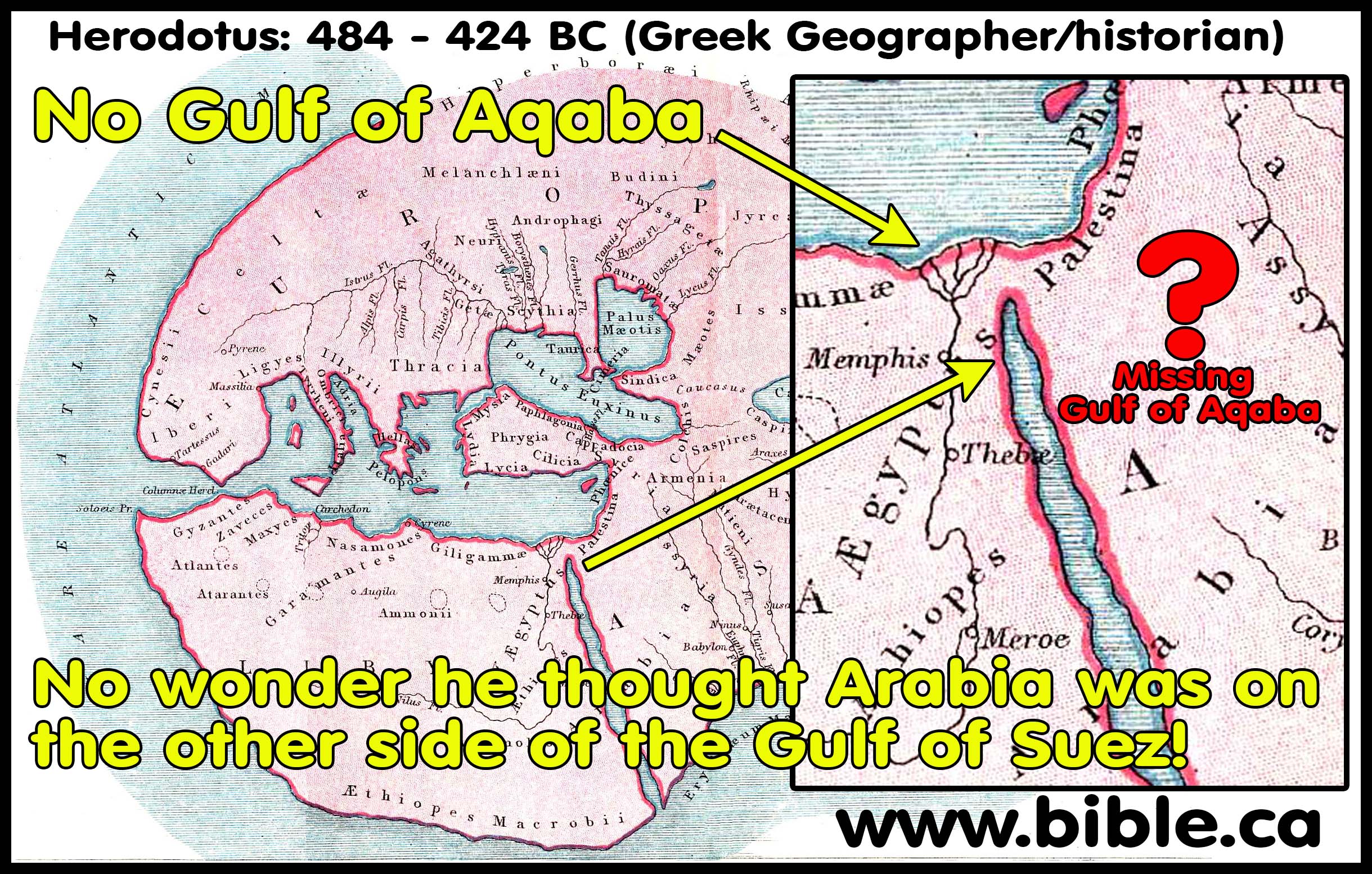
- MOST OF THE EXODUS ROUTE MAPS OF THE RENAISSANCE WERE WRONG: Without the Gulf of Aqaba, Arabia begins in the Sinai Peninsula!
- The 1589 AD map of Abraham Ortelius has
no concept of the Gulf of Aqaba:
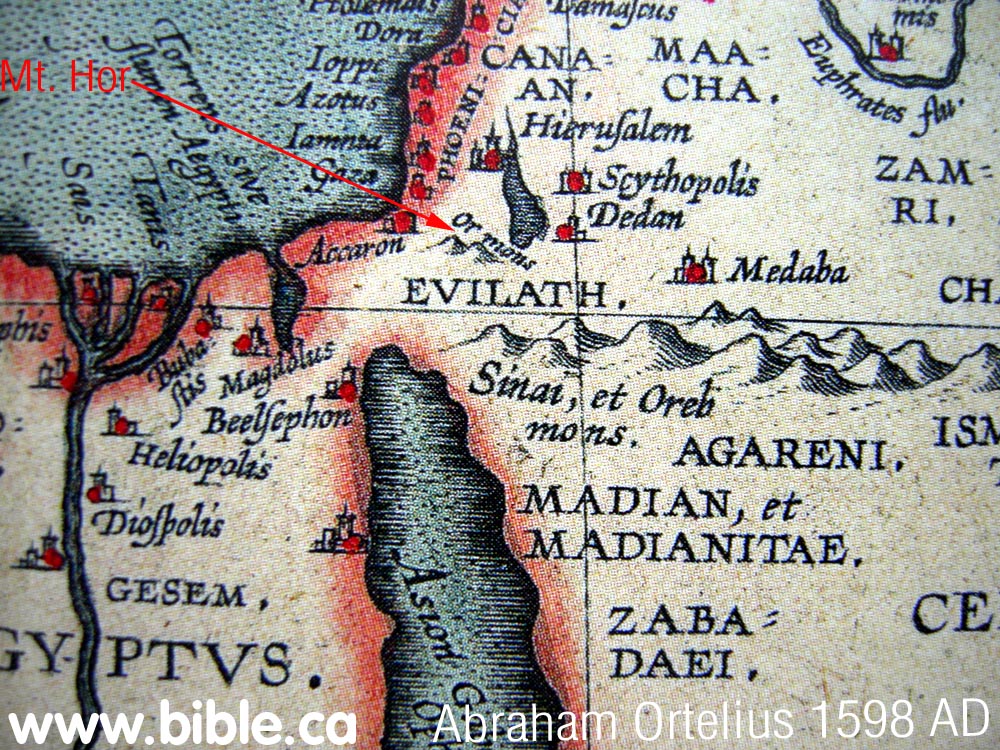
- Let us take note a few exceptions to this ignorance of the Sinai Peninsula and the Gulf of Aqaba.

- Agatharchides:
169 BC is unique in that he is one of the few geographers of his day
that understood the Gulf of Aqaba calling it the "Laeanites
Gulf". He restricts "Arabia" to south and east of the Gulf
of Aqaba. Agatharchides did not sail down the Laeanites Gulf, but says
the Arabs live on the east/south shore of the Gulf of Aqaba and that at
the end of the Gulf, is Petra! No Arabians lived in the Sinai Penisula.
As he sails down the Red Sea towards the Indian Ocean, he describes all
the various tribes of Arabians. No Arabians lived in the modern Sinai
Peninsula.
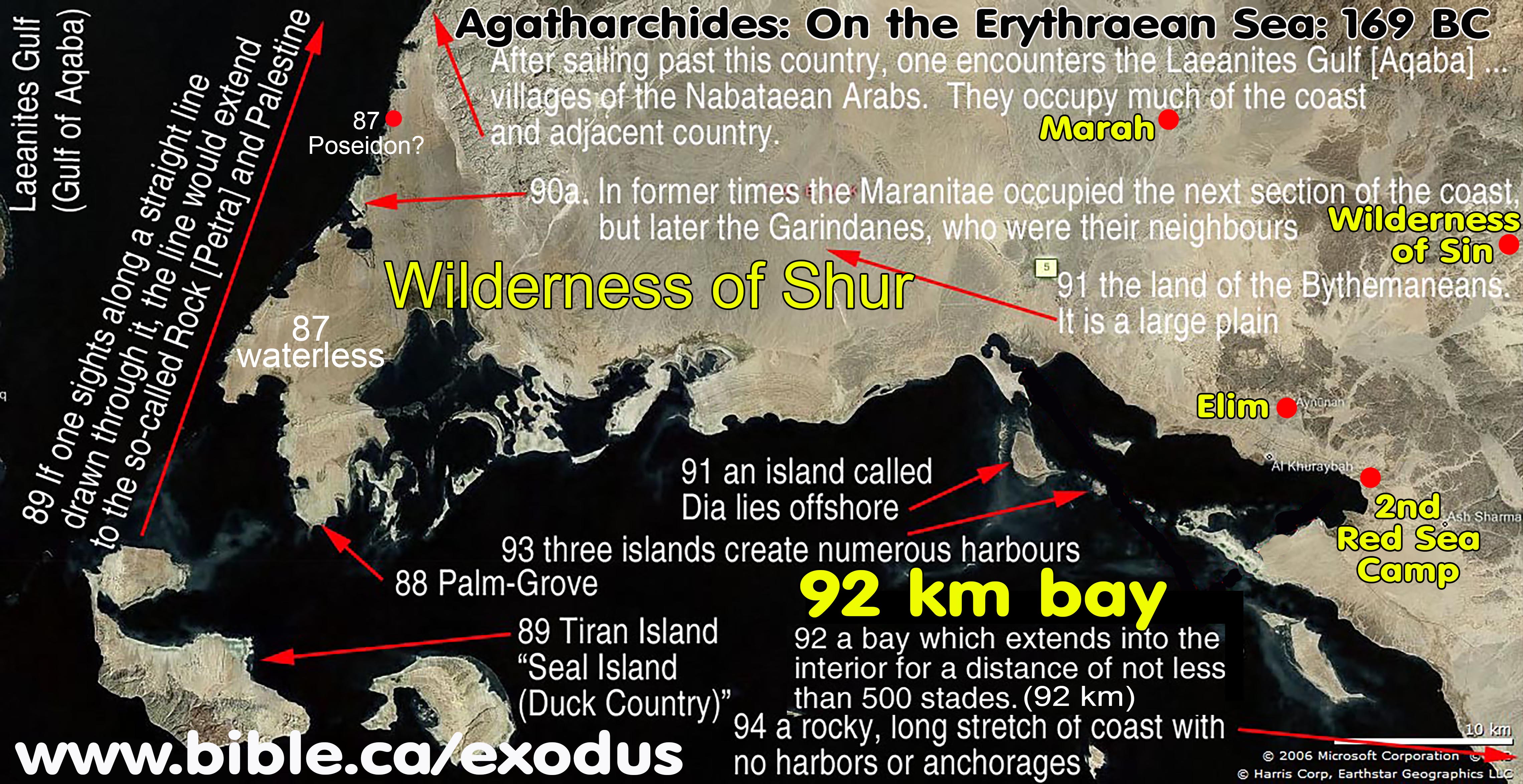
- Strabo:
15 AD is one of the few ancient
cartographers who understood the gulf of Aqaba and gives us great insight
into how Apostle Paul and Josephus viewed the Sinai Peninsula as NOT part
of Arabia. So finally when a cartographer correctly maps the gulf of
Aqaba, they correctly exclude the Sinai Peninsula from Arabia and locate
Arabia on the south of the gulf of Aqaba! "There is said to be a passage thence across, of
1260 stadia, to the city Aila (Aelana) [Elat], situated on the innermost
recess of the Arabian Gulf [Red Sea]. This recess has two branches, one, in the direction of Arabia [south of Gulf of Aqaba] and Gaza [north of
Gulf of Aqaba], is called Ailanites [Gulf
of Aqaba], from the city upon it; the other [Gulf of Suez] is in the
direction of Egypt, towards Hereopolis, to which from Pelusium is the
shortest road (between the two seas).
(Strabo, Geogr. 16.2.30)
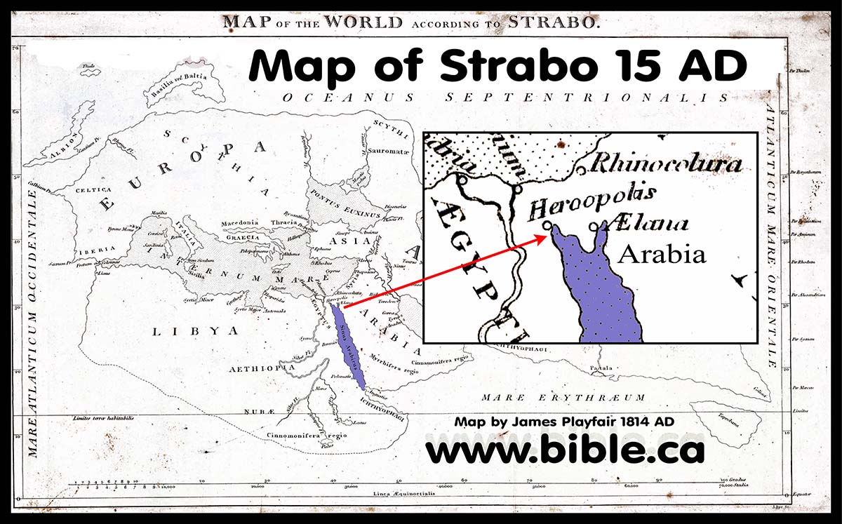
- The Peutinger
Map 330-381 AD is one of the oldest extant maps in the world and was
likely authored during the Constantine years. The Peutinger
Map correctly draws the Gulf of Aqaba in distinction with the Gulf of
Suez. Not surprisingly, Mt. Sinai is exactly where Constantine's mother chose
it, based upon a vision she saw in a dream. This is how the traditional
location of Mt. Sinai had its origin inside the Sinai Peninsula at St.
Catharine's Monastery. Although Kadesh Barnea is not named, the Nabatean
city of Petra (100 BC) is on the map. Eusebius believed Kadesh Barnea was
at Petra and that is why the Byzantines built a three memorial churches
at Petra. In the Late Bronze age of the Exodus (1446 BC) the name of
Petra was Kadesh Barnea, but it was called Sela (ie. rock), during the monarchy
(1000 BC). The name Petra, actually traces its origin back to the time
Moses brought water from the rock at Kadesh. What is interesting, is that
Josephus
and Eusebius both place Kadesh Barnea at Petra. So while the location of
Mt. Sinai was chosen by a dream, Kadesh Barnea was a known location
through Josephus and Eusebius
and his Onomasticon.
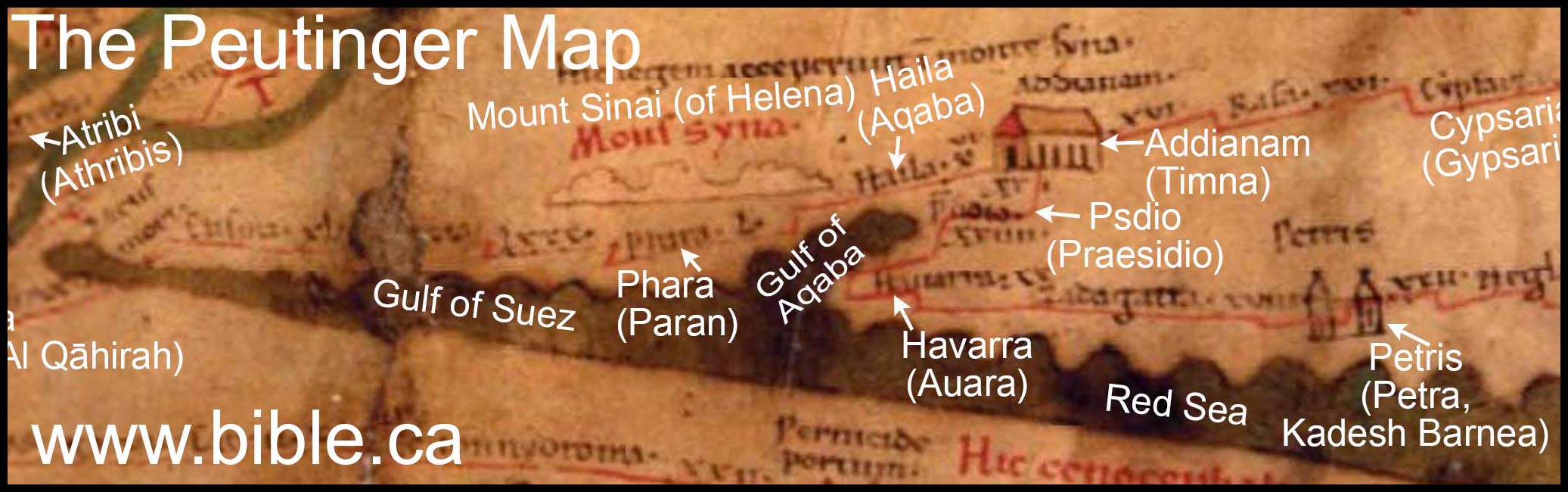
- Heinrich Bunting Hem of Germany (1585
AD) drew a rough version of the gulf of Aqaba, but most did not. Heinrich Bunting Hem, lived in Germany during the Renaissance,
in the 16th century. This is the century the Protestant revolution took
place in Germany. It appears that he was one of the few Renaissance
cartographers who understood the Gulf of Aqaba. He has a north Suez
crossing, Kadesh Barnea south of Beersheba and places Midian at Elat at
the north end of the Gulf of Aqaba. The map is clearly early since it
still uses the letter "i" in place of "J" in the
alphabet which the KJV of 1611 also used. The King James Version of 1611
spells Jesus' name as "Iesus" (iesus).
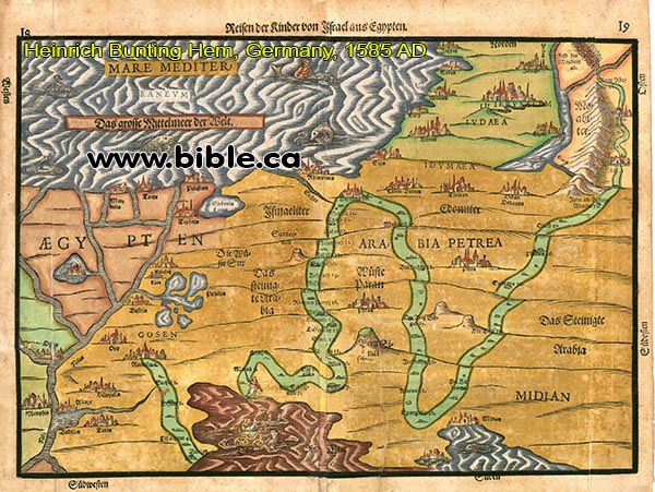
- In 1762 AD, Carsten Niebuhr is one of
the first to actually draw the Gulf of Aqaba somewhat correctly, although
his understanding was limited. He also placed the "Straights of
Tiran" on the map! This is the crossing point of the Red Sea, although
he probably didn't know it at the time. However he incorrectly mapped the
north end of the Gulf of Aqaba as a "forked tongue".
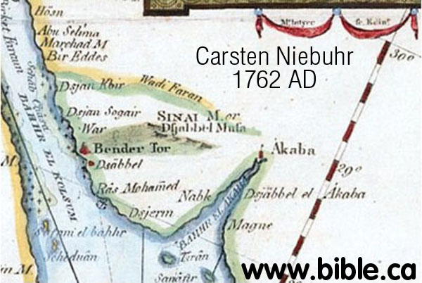
- Here is a full discussion of the rediscovery of the Gulf of Aqaba and its impact on the exodus route: catalogue of over 50 historic exodus route maps.
- See the entire Exhibit of Ancient and Antique Exodus route maps: www.bible.ca/archeology/bible-archeology-maps.htm.
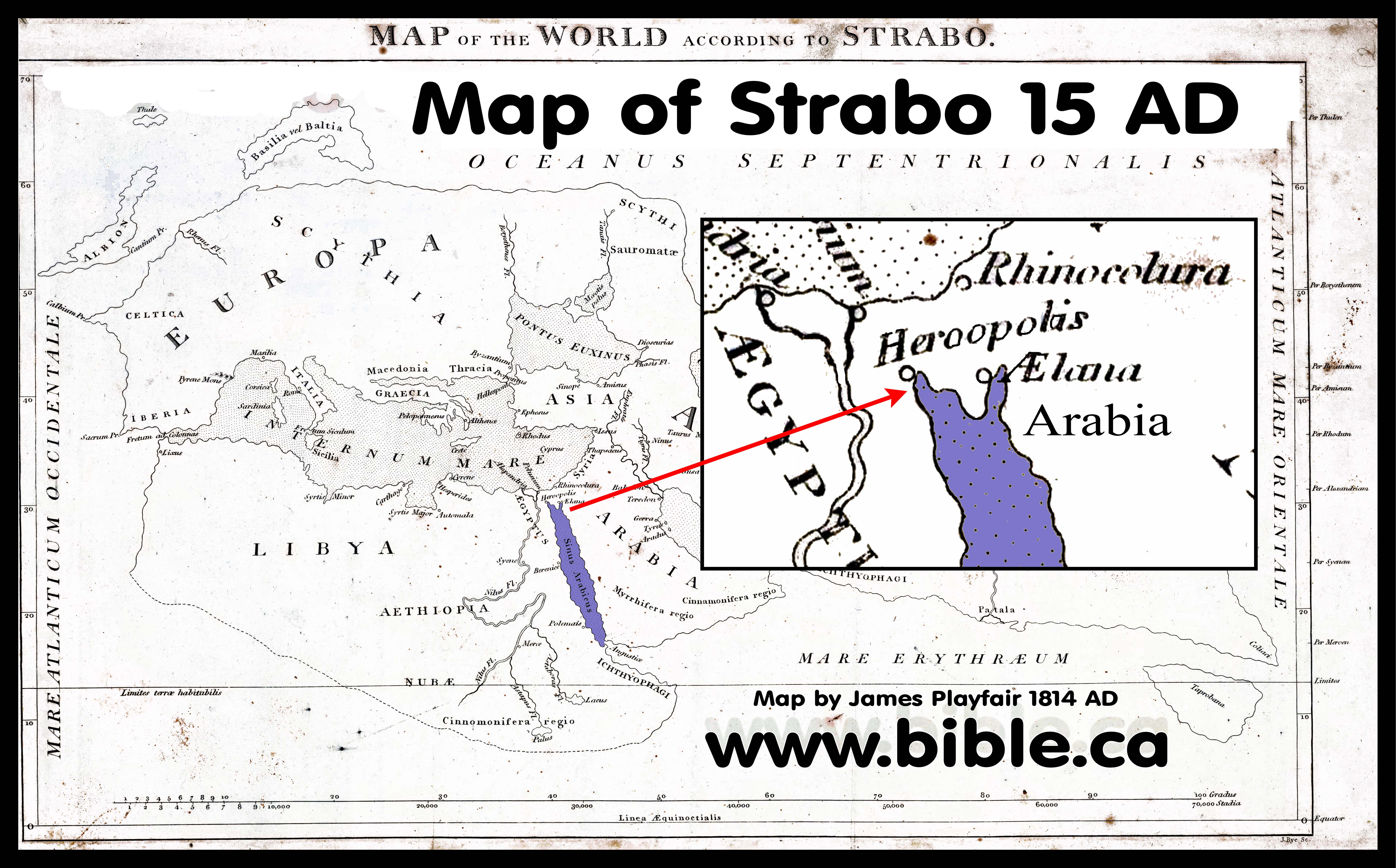
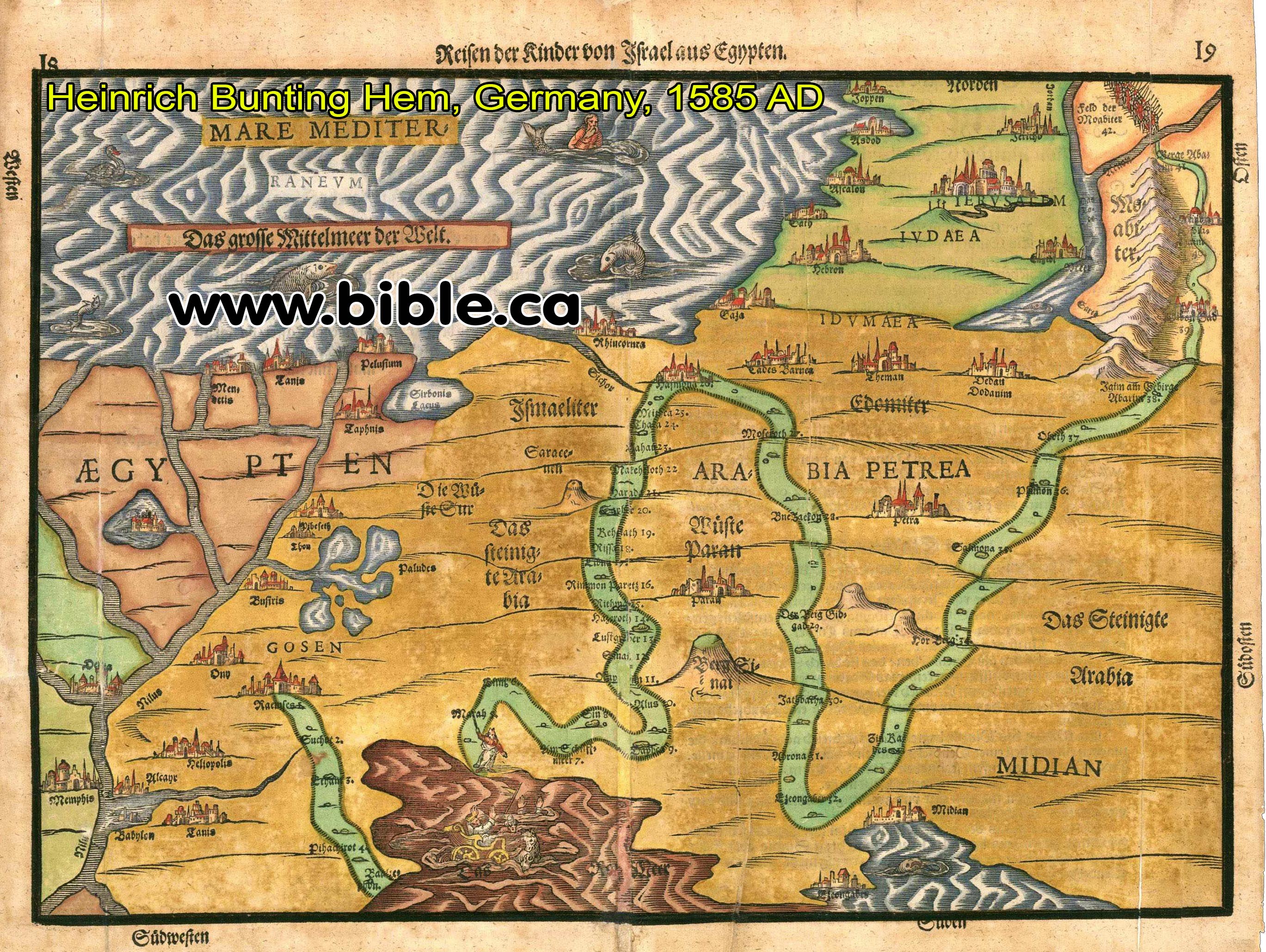
|
|
|
|
|
KEY#13 If you want to know how Paul defined Arabia, just ask Josephus, Strabo and Pliny, because they never call the Sinai Peninsula "Arabia". Josephus calls the Sinai Peninsula "Egypt" in Antiquities 5.78 |
A. Arabia at the time of Paul's conversion in 36 AD was the Nabatean kingdom with Petra as the capital city
- Mt. Sinai is located in Arabia not the Sinai Peninsula:
- Some have generated the fiction that the Nabatean Kingdom headquartered at Petra controlled the Sinai Peninsula. This is false.
- The Nabateans never controlled the Sinai Peninsula even though they did travel the caravan routes which crossed the Sinai of Egypt. Full study on Arabia at the time of Paul.
- Paul is the antitype of Moses in 25 direct parallels; one of them is that both Moses and Paul received the law at Mt. Sinai:
- Paul went to Arabia (Mt. Sinai) immediately after being converted: "But when God, who had set me apart even from my mother’s womb and called me through His grace, was pleased to reveal His Son in me so that I might preach Him among the Gentiles, I did not immediately consult with flesh and blood, nor did I go up to Jerusalem to those who were apostles before me; but I went away to Arabia, and returned once more to Damascus." (Galatians 1:15–17)
- "This is allegorically speaking, for these women are two covenants: one proceeding from Mount Sinai bearing children who are to be slaves; she is Hagar. Now this Hagar is Mount Sinai in Arabia and corresponds to the present Jerusalem, for she is in slavery with her children. But the Jerusalem above is free; she is our mother." (Galatians 4:24–26)
B. In 36 AD, ARABIA = NABATAEA= PETRA:
- The Nabatean Petrae kingdom WAS Arabia in the first century AD
- First century Arabia was the Nabatean Kingdom at Petra
- Arabia was a separate country from Rome when Aretus I,II, III, IV were the kings. Notice Aretas is called the KING OF ARABIA:
- Aretas is called the KING OF ARABIA:
- "Aretas king of Arabia" (Jos., Wars 1.124)
- "Aretas king of Arabia Petrea" (Jos. Ant. 17.287)
- "he also persuaded Hyrcanus to fly to Aretas, the king of Arabia, and to lay claim to the kingdom" (Josephus, Wars of the Jews 1.124)
- Aretas IV (4 BC - 40 AD) was the King of Arabia when Paul was converted at Damascus in 36 AD:
- In Paul's mind Arabia was Aretas IV: "In Damascus the ethnarch under Aretas the king was guarding the city of the Damascenes in order to seize me, and I was let down in a basket through a window in the wall, and so escaped his hands." (2 Corinthians 11:32-33)
- Here is the coin I have excavated of
Aretas IV at Kirbet El-Maqatir (Ephraim of John 11) in 2013, Cav1.
What you read in the book, you find in the ground!
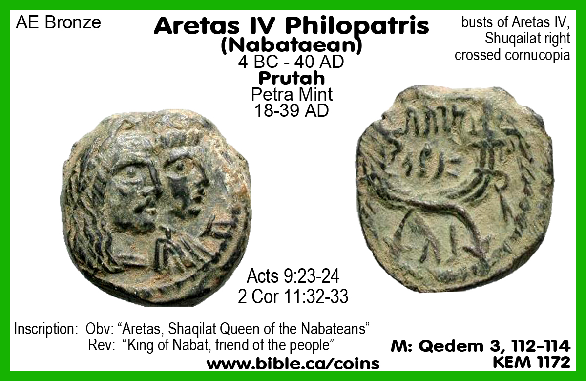
- The Nabateans extended their territory to the Negev, and controlled the trade routes that extended to Gaza and eventually took control of Damascus under Aretas III:
- "Nabatean Occupation: After Alexander’s death, independent kingdoms arose in Arabia. The Nabateans occupied the land vacated by the Edomites in northwest Arabia on the eastern side of the Aravah. They controlled the trade routes from southern and eastern Arabia to the Mediterranean. The Nabateans were nomadic herders who opposed Greek rule and culture (Bowersock, Roman Arabia, 13–14). They had considerable wealth, being the middlemen of the spice trade. By the time of the Maccabees in the second century bc, the Nabateans were relatively peaceful, settled traders (except for an episode of piracy on the Red Sea, for which they were “punished” by Ptolemaic naval forces), as opposed to other Arab tribes who were nomadic and violent (Bowersock, Roman Arabia, 20–21)." (The Lexham Bible Dictionary, Arabia, 2016 AD)
- The domain of Aretas IV Philopatris
(4BC-40 AD) as king of Nabatean Arabia Petrea at Paul's conversion in 36
AD was as follows:
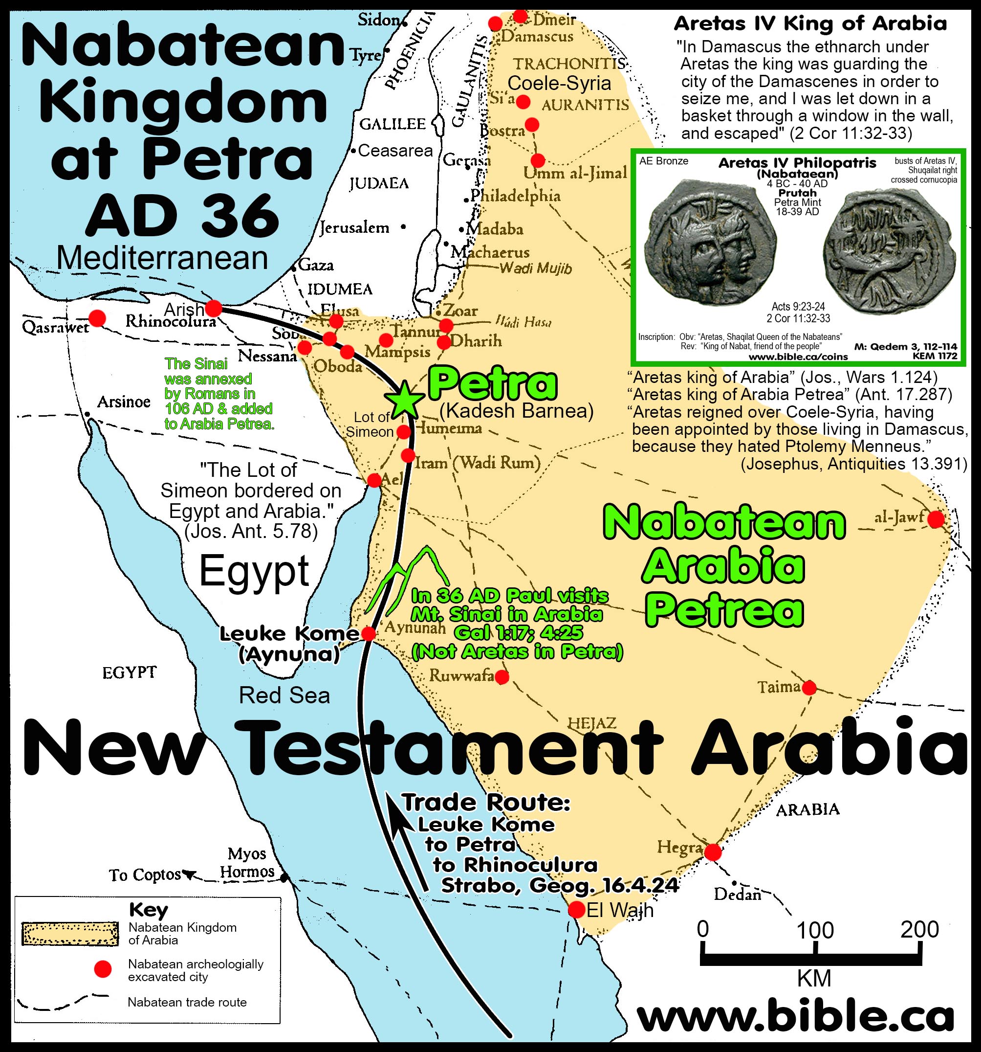
- Petra is Transjordan and the capital city of first century Arabia: "Since therefore Antipater saw that Hyrcanus did not attend to what he said, he never ceased, day by day, to charge feigned crimes upon Aristobulus, and to calumniate him before him, as if he had a mind to kill him; and so, by urging him perpetually, he advised him, and persuaded him to fly to Aretas, the king of Arabia; and promised, that if he would comply with his advice, he would also himself assist him, [and go with him]. (15) When Hyrcanus heard this, he said that it was for his advantage to fly away to Aretas. Now Arabia is a country that borders upon Judea. However, Hyrcanus sent Antipater first to the king of Arabia, in order to receive assurances from him, that when he should come in the manner of a supplicant to him, he would not deliver him up to his enemies. (16) So Antipater having received such assurances, returned to Hyrcanus to Jerusalem. A while afterward he took Hyrcanus, and stole out of the city by night, and went a great journey, and came and brought him to the city called Petra, where the palace of Aretas was." (Josephus, Antiquities 14.14-16)
- The Sinai Peninsula was outside Arabia and considered the land of Egypt when Joshua gives Simeon his land which bordered on EGYPT: "The lot of Simeon, which was the second, included that part of Idumea which bordered upon Egypt and Arabia." (Josephus, Antiquities 5.78)
- The Arab Peninsula from the Persian Gulf to the Red Sea up to the Gulf of Aqaba and Transjordan.
- Macherus was on the border between Rome and Arabia: The area east of the Salt Sea, west of Machaerus where John the Baptist was beheaded: "Macherus, which is a place on the borders of the dominions of Aretas and Herod" (Josephus, Antiquities 18.111)
- Arabia controlled the eastern portion of Syria around Damascus:
- "Aretas reigned over Coele-Syria, being called to the government by those that held Damascus, by reason of the hatred they bare to Ptolemy Menneus. He also made thence an expedition against Judea, and beat Alexander in battle, near a place called Adida; yet did he, upon certain conditions agreed on between them, retire out of Judea." (Josephus, Antiquities 13.391)
- At their zenith of territorial expansion and control under Aretas IV Philopatris (4BC-40 AD), the Nabateans occupied a collection of towns (Oboda, Sobata, Elusa, Ruheiba, Nessana, Mampsis, Advat) just south of Beersheba in Judah.
- Oboda was founded in the early Greek period (300 BC).
- However, around 25 AD, the Romans had learned to use the Monsoon winds to successfully sail directly by sea which decimated the Nabatean economy.
- Then these cities were destroyed 40-70 AD and the Nabateans were driven back to their Transjordan territory.
- "According to the archaeological evidence Oboda was settled for the first time at the end of the 4th century or early in the 3rd century bc by the Nabateans, who established a halt there on the caravan route from Petra to Gaza. The conquest of Gaza by Alexander Jannaeus, the Hasmonean monarch, in about 100 bc put an end to the Nabatean hold on the Negev. At the end of the 1st century bc, during the reign of Aretas IV, Oboda was rebuilt and enjoyed a period of glory, as is well attested by numerous inscriptions and other archaeological finds. In about the middle of the 1st century ad the city was sacked, probably by newly arrived nomadic tribes from Arabia, whose rock drawings and graffiti were found on rocks around the site." (The Archaeological Encyclopedia of the Holy Land, Oboda, 1986 AD)
- "After his death Obodas was buried at Oboda, the town named after him. Obodas was deified and—as evidenced by Nabatean and Greek inscriptions—his cult persisted at Oboda until the 3rd century AD. Without waiting for Augustus’ confirmation Aretas IV (4 BC–AD 40), son of Obodas, ascended the throne. In his coins and inscriptions he is known by the title ‘he who loved his people’. During his reign the kingdom reached its highest point, both economically and in its architecture, sculpture, painting and pottery. Except for the dispatch by Aretas of a military force to quell some riots in Judea after Herod’s death in 1 BC (Josephus, Antiq. xvii, 287), and a mention of him as ruler of Damascus in AD 39 (2 Cor. 11:32), there is little about him in the ancient sources. On the other hand an exceedingly large number of inscriptions, dated by the years for which Aretas IV had reigned, have been found in every quarter of the kingdom, from northern Arabia in the south to southern Syria in the north, and to Oboda and Sobata in the west. These testify to the great expansion of the kingdom. The decline set in during the reign of Malichus II (AD 40–70), the first-born son of Aretas IV. First the Nabateans lost Damascus. In AD 67 Malichus sent an army to help Vespasian in the siege of Jerusalem (Josephus, War iii, 68). Otherwise he is little mentioned. It was in his time that the Romans learned to make use of the southwest monsoon. Earlier in the 1st century AD Hippalus had discovered that the monsoon made it possible to sail safely to India and back and they were therefore able to bring spices and aromatics directly from India to Alexandria and thence to Rome, dealing a mortal blow to the Nabatean economy. In about AD 50 it seems to have suffered another blow. New tribes migrated from Arabia to the southern parts of the kingdom and penetrated the Negev, where they destroyed Oboda and the forts on the Petra-Gaza road." (The Archaeological Encyclopedia of the Holy Land, Nabateans, 1986 AD)
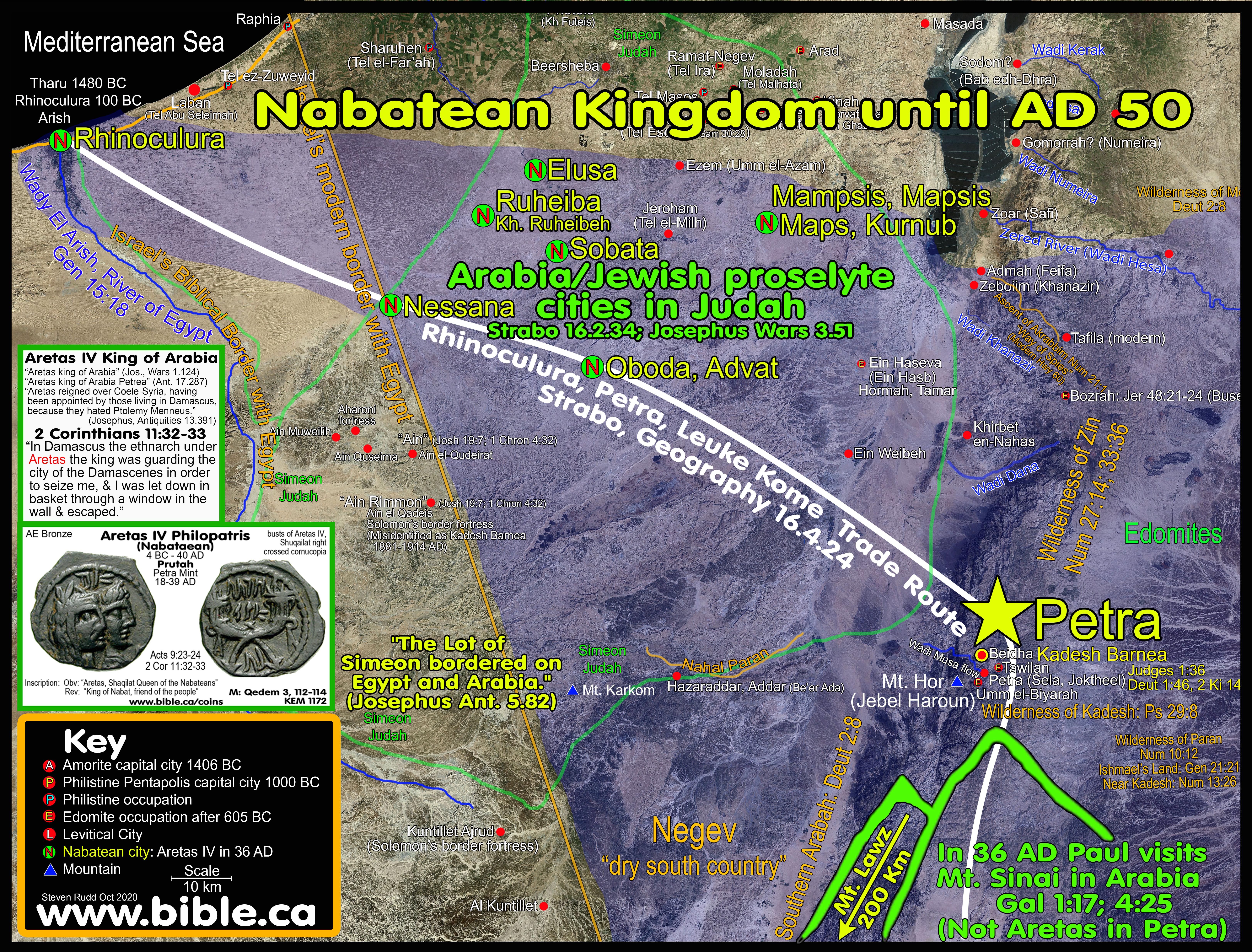
"Rome annexed Nabatean kingdom and added the Sinai Peninsula FROM EGYPT to form the New triplet Arabia in 106 AD under Trajan. "It was not until 106 AD that the Romans officially annexed Nabatea and the “area around Petra” (Millar, Roman Near East, 94). Eventually, Rome extended their territory as far as Meda’in Saleh—300 miles south of Petra. Rome designated three sub-regions within Arabia: Arabia Petraea (Sinai and the old territory of Nabatea), Arabia Felix (the southwestern coast of the Arabian Peninsula), and Arabia Deserta (roughly the rest of Arabia). The Romans would control Arabia until the rise of the Islamic Arabian Empires of the seventh century." (Lexham Bible Dictionary, Arabia, 2016 AD)
- The Nabatean kingdom was conquered by Trajan in AD 106 and the Romans annexed of the Sinai Peninsula from the Egyptians when it was formally labelled Arabia Petraea.
- "It was not until 106 AD that the Romans officially annexed Nabatea and the “area around Petra” (Millar, Roman Near East, 94). Eventually, Rome extended their territory as far as Meda’in Saleh—300 miles south of Petra. Rome designated three sub-regions within Arabia: Arabia Petraea (Sinai and the old territory of Nabatea), Arabia Felix (the southwestern coast of the Arabian Peninsula), and Arabia Deserta (roughly the rest of Arabia). The Romans would control Arabia until the rise of the Islamic Arabian Empires of the seventh century." (Lexham Bible Dictionary, Arabia, 2016 AD)
9. If the Sinai Peninsula was not considered Arabia at the time of Paul, it is impossible for Mt. Sinai to be located in the modern Sinai Peninsula.
C. Ask Josephus where "Arabia" was and find Mt. Sinai in Transjordan Saudi Arabia!
- Josephus calls the Sinai Peninsula "Egypt". When Joshua gave Simeon his land in the Negev, Josephus said it bordered on EGYPT:
- "The lot of Simeon, which was the second, included that part of Idumea which bordered upon Egypt and Arabia." (Josephus, Antiquities 5.78)
- The only place Egypt can border Simeon is the Sinai Peninsula, proving the entire Sinai was Egypt both at the time of the Exodus and in the first century AD when Josephus lived.
- Josephus never calls the Sinai Peninsula "Arabia": NOT EVEN ONCE!
- Josephus uses the word Arabia/Arabian 241 times and NEVER ONCE IN REFERENCE TO THE SINAI PENINSULA.
- Josephus did not consider the modern Sinai Peninsula to be Arabia.
- It is clear that Josephus used the term Arabia exclusively as Transjordan, whose capital was located at Petra.
- Remember that the Nabateans controlled cities in the Judean Negev and Transjordan north to Damascus!
- Coins at Gamla were minted while Josephus was part of the rebel forces fighting Rome in the First Jewish War 66-69 AD)
- Here is one of the Gamla revolt coins I
excavated at Khirbet el-Maqatir in 2013 AD, Cav1:
- While in jail, Josephus found favor and composed his famous Jewish Wars as he became the war recorder for Titus in AD 70.
- King Agrippa II buys a copy of Joseph's book and Josephus actually describes his capture, captivity and writing his book: "As for myself, I have composed a true history of that whole war, and all the particulars that occurred therein, as having been concerned in all its transactions; (48) for [at Gamla] I acted as general of those among us that are named Galileans, as long as it was possible for us to make any opposition [First Jewish War: 66-69 AD]. I was then seized on by the Romans, and became a captive. Vespasian also and Titus had me kept under a guard, and forced me to attend them continually. At the first I was put into bonds; but was set at liberty afterward, and sent to accompany Titus when he came from Alexandria to the siege of Jerusalem; (49) during which time there was nothing done which escaped my knowledge; for what happened in the Roman camp I saw, and wrote down carefully; and what information the deserters brought [out of the city], I was the only man that understood them. (50) Afterward I got leisure at Rome; and when all my materials were prepared for that work, I made use of some persons to assist me in learning the Greek tongue, and by these means I composed the history of those transactions; and I was so well assured of the truth of what I related, that I first of all appealed to those that had the supreme command in that war, Vespasian and Titus, as witnesses for me, (51) for to them I presented those books first of all, and after them to many of the Romans who had been in the war. I also sold them to many of our own men who understood the Greek philosophy; among whom were Julius Archelaus, Herod [king of Chalcis], a person of great gravity, and king Agrippa himself, a person that deserved the greatest admiration." (Josephus, Against Apion 1.47-51)
- After 70 AD when Josephus wrote his famous book, the Nabatean Empire had lost its presence in the Negev of Judea and was now entirely Transjordan.
- This explains why to Josephus in AD 70, Arabia was not in southern Judea and certainly never in the Sinai Peninsula.
- A careful study of original sources will prove that in the first century, the Nabatean's did not control the Sinai Peninsula.
D. Strabo (15 AD) viewed "Arabia" as Petra
- In the mind of Strabo, Arabia was east of Judea, south of Syria, west of the Euphrates and the northern portion of modern Saudi Arabia to the exclusion of the Sinai Peninsula.
- Strabo defines "Arabia proper" as being Transjordan: "Above [ie to the east: East-up map] Judæa and Cœle-Syria, as far as Babylonia and the river tract, along the banks of the Euphrates towards the south, lies the whole of Arabia" (Strabo, Geography 16.3.1)
- Strabo says Arabia begins from Babylon and goes west through the Arabian Desert. "ARABIA commences [begins] on the side of Babylonia with Mæcene. In front of this district, on one side lies the desert of the Arabians, on the other are the marshes opposite to the Chaldæans, formed by the overflowing of the Euphrates, and in another direction is the Sea of Persia." (Strabo, Geography 16.4.1)
- Strabo continues to define "Arabia" through Eratosthenes, as being Transjordan in north Saudi Arabia in distinction to "Arabia Felix": "I return to the opinions of Eratosthenes, which he next delivers respecting Arabia. He is speaking of the northern and desert part, lying between Arabia Felix, Cœle-Syria, and Judæa, to the recess of the Arabian Gulf." (Strabo, Geography 16.4.2)
- Strabo defines Arabia proper as being Transjordan, south of the gulf of Aqaba, east of the main branch of the Red Sea (south of the Straits of Tiran) and west to the Persian gulf: "When we were describing Arabia, we included in the description the gulfs which compress and make it a peninsula, namely the Gulfs of Arabia [section below the tri-intersection of the Gulfs of Suez, Aqaba and Arabian] and of Persis [Persian gulf near Babylon]. (Strabo, Geography 17.1.1)
- Strabo calculates the length of the Red Sea from the Gulf of Aqaba to the Indian Ocean and says the area south of the Aqaba and east of the Red Sea is ARABIA: "The part of the Arabian Gulf along the side of Arabia, if we reckon from the recess of the Ælanitic bay, is, according to the accounts of Alexander and Anaxicrates, 14,000 stadia in extent; but this computation is too great." (Strabo, Geography 16.4.4)
- Strabo may have defined Lower Egypt as being the Sinai Peninsula. The southern limit of the Gulf of Aqaba may be not only where the Gulf of Aqaba intersects the Red Sea at the Straits of Tiran, but also the full length of the Gulf of Aqaba as well: "But Lower Egypt and the country as far as the Lake Sirbonis were sea, and confluent perhaps with the Red Sea at Heroopolis, and the Ælanitic (Aqaba) recess of the gulf." (Strabo, Geogr. 17.1.35)
E. Agatharchides: 169 BC describes "Arabia" in great detail, including the various Arabian tribes.
- Agatharchides first specifically defines the gulf of Aqaba (Laeanites Gulf), then says that Arabia lies to the south of the gulf of Aqaba and east of the Arabian Sea (Main branch of the Red Sea south of the Gulf of Aqaba)
- Agatharchides did not sail down the Laeanites Gulf (Aqaba), but says the Arabs live on the east/south shore of the Gulf of Aqaba and that at the end of the Gulf, is Petra!
- Agatharchides never says that any Arabians lived in the Sinai Penisula.
- As
he sails down the Red Sea towards the Indian Ocean (Erythraean Sea), he
describes all the various tribes of Arabians.
F. Pliny the Elder, (died 79 AD) defines Arabian nations in Saudi Arabia
1. “The Arabian nations of the Canchlæi join these on the east, and, on the south the Cedrei [modern el- Hejaz], both of which peoples are adjoining to the Nabatæi. The two gulfs of the Red Sea, where it borders upon Egypt, are called the Heroöpolitic [Bahr-el-Soueys or Gulf of Suez] and the Ælanitic [Bahr-el-Akabah, or Gulf of Akabah]. Between the two towns of Ælana [Elat/Aqaba] and Gaza upon our sea there is a distance of 150 miles. Agrippa says that Arsinoë [north shore of gulf of Suez], a town on the Red Sea, is, by way of the desert, 125 miles from Pelusium. How different the characteristics impressed by nature upon two places separated by so small a distance!” (Pliny the Elder, Natural History 5.12, died 79 AD)
a. “Immediately following this, and in one of Pliny’s frequent bursts of clarification, he recites Agrippa’s distances between the cities of Pelusium and Arsinoe (125 [Roman] miles=115 statute miles), and between Gaza and Aelana (150 [Roman] miles=137 statute miles). The fact that Agrippa’s mileage between Gaza and Aelana corresponds almost to the mile when compared with modern air mileage (=138 statute miles) provides compelling evidence that the location of Aelana and the northernmost stretch of the Gulf of Aqaba was well known and understood in the early classical period.” (The Red Sea in Biblical, Classical and Early Cartographically related traditions, Barry J. Beitzel, NEAS annual meeting, 2016 AD)
2. Pliny assigns the Arabian people in Hejaz (Modern Saudi Arabia)
3. Pliny also says that Egyptian territory included the modern Sinai Peninsula since the gulf of Aqaba “borders on Egypt”.
4. Pliny clearly defines the Gulf of Suez as being part of the Red Sea.
G. This provides conclusive proof that in the mind of Paul, Agatharchides, Strabo, Pliny and Josephus, that Arabia WAS NEVER the Sinai Peninsula, contrary to what the fiction writers or those with an overactive imagination boldly assert.
- Those who say the Sinai Peninsula was viewed by Paul as being "in Arabia", are perpetuating a fiction, creating confusion and causing a hindrance to identifying the true location in north Saudi Arabia.
- The location of Arabia proper really hasn't ever changed, from the time of the Exodus (1446 BC) when Israel arrived at Mt. Sinai down to the time of when Paul visited Mt. Sinai IN ARABIA in 36 AD.
- There has never been a time in history that the Sinai Peninsula was defined as Arabia.
- Even today the Sinai Peninsula is Egypt not Arabia.
|
|
|
|
|
KEY#14 ISHMAEL IS ARABIA: Find Ishmael, find Sinai! The wilderness of Shur and Paran is where Ishmael lived Ishmael = Midian = Hagar = Sinai |
|
"This is allegorically speaking, for these women are two covenants: one proceeding from Mount Sinai bearing children who are to be slaves; she is Hagar. Now this Hagar is Mount Sinai in Arabia and corresponds to the present Jerusalem, for she is in slavery with her children. But the Jerusalem above is free; she is our mother. For it is written, “Rejoice, barren woman who does not bear; Break forth and shout, you who are not in labor; For more numerous are the children of the desolate Than of the one who has a husband.” And you brethren, like Isaac, are children of promise. But as at that time he who was born according to the flesh persecuted him who was born according to the Spirit, so it is now also. But what does the Scripture say? “Cast out the bondwoman and her son, For the son of the bondwoman shall not be an heir with the son of the free woman.” So then, brethren, we are not children of a bondwoman, but of the free woman." (Galatians 4:24-31) |
|
- HAGAR = ISHMAEL = MIDIAN= ARABIA = MT. SINAI: Paul's Allegory in Gal 4 about Mt. Sinai:
- It is actually shocking that for all the efforts to locate Mt. Sinai, that so many completely ignore the fact that Paul located Mt. Sinai, NOT ONLY in Arabia, but where Hagar lived.
- In 2066 BC Abraham and Hagar are the parents of Ishmael who became the Ishmaelite tribe.
- In 2066 BC Abraham and Keturah are the parents of Midian who became the Midianites.
- Ishmael and Midian were brothers who lived in the same exact geographic location and intermarried to become one people by the time Joseph entered Egypt in 1899 BC
- In 225 BC, Demetrius the Chronographer connected Moses living in Midian as the place to which Abraham sent his two sons Ishmael and Midian to live.
- "There is, therefore, no inconsistency in Moses and Zipporah having lived at the same time. And they lived in the city of Midian, which was named from one of the sons of Abraham. For it (i.e. Scripture) says that Abraham sent his sons to the East to settle there. And (it says that) for this reason also, Aaron and Miriam said at Hazeroth that Moses had married an Ethiopian woman." (Eusebius, Preaparatio Evangelica 9:29.1-3, quoting Demetrius the Chronographer, 225 BC)
- This places the burning bush and the Mountain of God in Saudi Arabia.
- Find Ishmael; find Sinai because ISHMAEL IS ARABIA.
- The Bible is quite explicit that Ishmael lived Transjordan in the wilderness of Shur and the wilderness of Paran.
- Ishmael NEVER lived in the Negev of
Judah/Simeon as witnessed by their absence during the conquest of Joshua
in 1406-1399 BC
- FIND MIDIAN, FIND BURNING BUSH, FIND SINAI: Ishmaelites = Midianites = Midian: There is almost universal agreement that Midian was in north west Saudi Arabia, beside the Straits of Tiran. The Ishmaelites and the Midianites were both sons of Abraham through different mothers around 2066 BC. When Joseph was sold by his brothers in 1899 BC into slavery, the Midianites and Ishmaelites had intermarried and become the same people. This can be proven by their interchangeable use in the Biblical narrative. Midian was Abraham's son through Keturah (Gen 25:2); Ishmael was Abraham's son through Hagar. Although originally different sons of Abraham, the Midianites and Ishmaelites melded into a single group of people from the same region.

|
Gordon Franz gives the store away! |
"I would agree with the proponents of Jebel al-Lawz that Midian is in the area of northwestern Saudi Arabia today. I think most scholars would attest to that (Parr 1989: 39-66; 1996: 213-218)." (Gordon Franz, Is Mount Sinai In Saudi Arabia?, Bible and Spade, Volume 13, Page 105, 2000 AD) |
- Midianites and Ishmaelites are used interchangeably in the story of selling Joseph to Egypt: Gen 37:25-28,36; 39:1; Judg 8:22-24.
i. "Then they sat down to eat a meal. And as they raised their eyes and looked, behold, a caravan of Ishmaelites was coming from Gilead, with their camels bearing aromatic gum and balm and myrrh, on their way to bring them down to Egypt. Judah said to his brothers, "What profit is it for us to kill our brother and cover up his blood? "Come and let us sell him to the Ishmaelites and not lay our hands on him, for he is our brother, our own flesh." And his brothers listened to him. Then some Midianite traders passed by, so they pulled him up and lifted Joseph out of the pit, and sold him to the Ishmaelites for twenty shekels of silver. Thus they brought Joseph into Egypt. " Genesis 37:25-28
ii. "Meanwhile, the Midianites sold him in Egypt to Potiphar, Pharaoh's officer, the captain of the bodyguard." Genesis 37:36
iii. "Now Joseph had been taken down to Egypt; and Potiphar, an Egyptian officer of Pharaoh, the captain of the bodyguard, bought him from the Ishmaelites, who had taken him down there. " Genesis 39:1
- The Midianites were also called Ishmaelites who oppressed Israel 7 years and Gideon beat them in battle: "Then the men of Israel said to Gideon, "Rule over us, both you and your son, also your son's son, for you have delivered us from the hand of Midian." But Gideon said to them, "I will not rule over you, nor shall my son rule over you; the Lord shall rule over you." Yet Gideon said to them, "I would request of you, that each of you give me an earring from his spoil." (For they had gold earrings, because they were Ishmaelites.) " Judges 8:22-24
- Ishmael lived in the wilderness of Shur:
- “He [Ishmael] will be a wild donkey of a man, His hand will be against everyone, And everyone’s hand will be against him; And he will live to the east [Transjordan] of all his brothers.”" (Genesis 16:12)
- "They settled from Havilah to Shur which is east of Egypt as one goes toward Assyria; he settled in defiance of all his relatives." (Genesis 25:18)
- "He lived in the wilderness of Paran, and his mother took a wife for him from the land of Egypt." (Genesis 21:21)
- The Ishmaelites are grouped with other Transjordan tribes: "The tents of Edom and the Ishmaelites, Moab and the Hagrites; Gebal and Ammon and Amalek" Psalm 83:6
- "Transjordanian tribes of Gad and Manasseh, subjected the Hagrites and took control of their territory “until the [Assyrian] exile” (1 Chr 5:10, 19–22). Since the Hagrites are listed with other Transjordanian enemies of Israel during the preexilic period—Edom, the Ishmaelites, and Moab (Ps 83:7—Eng 83:7)—it appears that the hostilities continued even afterwards." (ABD, Hagrites)
- Ishmael lived in the wilderness of Paran
- Kadesh Barnea (modern Petra) was in the larger wilderness of Paran on the border of Edom. The Ancient Arabia (the Ishmaelites) did not live at Petra. However in the first century, modern Arabians (Nabateans) had their capital city at Petra, which was still inside the wilderness of Paran, the ancient wilderness where Ishmael lived. "they proceeded to come to Moses and Aaron and to all the congregation of the sons of Israel in the wilderness of Paran, at Kadesh; and they brought back word to them and to all the congregation and showed them the fruit of the land." (Numbers 13:26)
- Shur is on the far side of the Red Sea crossing: "Then Moses led Israel from the Red Sea, and they went out into the wilderness of Shur; and they went three days in the wilderness and found no water." (Exodus 15:22)
- Paran is located after they left Mt. Sinai to Kadesh: "the sons of Israel set out on their journeys from the wilderness of Sinai. Then the cloud settled down in the wilderness of Paran." (Numbers 10:12)
- The wilderness of Paran is Transjordan because when Moses spoke the words of Deuteronomy in the Wadi Zared, he was near Mt. Paran: "These are the words which Moses spoke to all Israel across the Jordan in the wilderness, in the Arabah opposite Suph, between Paran and Tophel and Laban and Hazeroth and Dizahab." (Deuteronomy 1:1)
- The Amalekites lived near Mt. Sinai in north Saudi Arabia:
- "Now David and his men went up and raided the Geshurites and the Girzites and the Amalekites; for they were the inhabitants of the land from ancient times, as you come to Shur even as far as the land of Egypt." (1 Samuel 27:8)
- Havilah is at the southern end of the Arabian Peninsula.
|
Gen 25:18 |
Ishmael settled |
from Havilah to Shur |
which is east of Egypt as one goes toward Assyria |
|
1 Samuel 15:7 |
Amalekites |
from Havilah as you go to Shur |
which is east of Egypt |
|
1 Samuel 27:8 |
Amalekites from ancient times |
as you come to Shur |
even as far as the land of Egypt |
- Mt. Sinai is located in the territory of Ishmael/Midian which is Transjordan in the wilderness of Shur and the wilderness of Paran in Saudi Arabia but never in the Sinai Peninsula. Gal 4:25 says that Mt. Sinai is in Arabia, where Ishmael lived.
- My thesis has used the "Bible only" to determine the exodus route.
- Once the information from inspired scripture was exhausted, only then did I supplement it with cartography, geography, history and archeology.
- Scripture alone is the only infallible record of history and it trumps the opinions of men, including mine.
- RED SEA CROSSING:
- Scripture alone leads us to conclude that only the Straits of Tiran fulfills all the requirements to be the Red Sea crossing point.
- This forces the location for the Wilderness of Shur (Ishmael and Midian) to be in north western Saudi Arabia, even though scripture already told us that's where Hagar and Ishmael lived.
- Any crossing point on the Gulf of Aqaba forces Mt. Sinai to be in north Saudi Arabia.
- MOUNT SINAI:
- Most important, of course, is that most miss the gorilla in the room in Paul's statement: "Now this Hagar is Mount Sinai in Arabia" (Galatians 4:25) Paul directly associated Mt. Sinai with the historic territory of the Ishmaelites/Midianites (Hagar), in Saudi Arabia.
- Gordon Franz argues that Goshen was in Arabia, but he was looking for the wrong thing. Forget finding Arabia. Paul's point in Gal 4:25 is simple: FIND ISHMAEL, find Sinai. This ruled out the entire Sinai Peninsula and utterly refutes Franz by his own words, since he locates Ishmael in the land of Midian near Mt. Lawz in Saudi Arabia.
- With Josephus, Jebel Lawz fits his description that "Sinai was the highest mountain in the region".
- There is nothing archeology can provide to support Mt. Lawz is Mt. Sinai. Please ignore 100% of Ron Wyatt's unicorn archeological proofs that Lawz is Mt. Sinai.
- KADESH BARNEA:
- Using Scripture alone to trace the southern border of Judah, we can prove beyond doubt, Kadesh Barnea is Transjordan southeast of the Salt Sea near Petra.
- With Josephus, we are able to pin Kadesh at Petra.
- With Archeology, El Beidha, located 5 km north of Petra, becomes the best location for Kadesh since it is one of the oldest cities in the world. Indeed, Abraham visited Kadesh Barnea about 2050 BC in Genesis 14:7 when it was called "En-mishpat".
- Even with extensive professional excavations at Petra or El Beidha, there is nothing from archeology that provides any direct occupational evidence for the Hebrews in either location.
- Josephus confirms the ancient tradition that Aaron was buried at Mt. Hor, 3 km to the west of Petra on the eastern side of the Arabah valley.
- Other evidentiary synchronisms for Kadesh at Petra include: the spring of Moses (Ein Musa), the river of Moses (Wadi Musa = the Siq), Petra being a burial city (necropolis), modern Jews refer to their funerals as a "Kadesh" (holy).
- Most important, unlike Piltdown Kadesh at Ein Qudeirat where most modern bible maps put Kadesh since 1916 AD, Petra is not inside the promised land.
- When you use the Bible as your infallible guide and get the chronology right, the geography right, the archeology right and the history right you restore the Exodus route. Praise God!
By Steve Rudd: 2005 - October 2016: Contact the author for comments, input or corrections.
BECOME A CHRISTIAN TODAY:
Today in your personal life, when you reach your "Ethan" and feel "trapped" with nowhere to go while the Devil keeps his eye on you from his Migdol military watchtower, remember that God will always provide the way of escape. We escape the slavery to sin when we are baptized by full immersion like Israel through the Red Sea. As Christians, we are "the church in the wilderness" awaiting the time when our Saviour Jesus/Joshua returns from spying out the land (Hebrews 6:19-20) and we will cross the Jordan to live with God forever in the promised land of Heaven. "This hope we have as an anchor of the soul, a hope both sure and steadfast and one which enters within the veil, where Jesus has entered as a forerunner for us, having become a high priest forever according to the order of Melchizedek." (Hebrews 6:19-20)
|
|
Why not attend a good Bible believing local church Click here to find the closest assembly of Christians to your house. |
The Great Exodus Psalm:
"He divided the sea and caused them to pass through, And He made the waters stand up like a heap. Then He led them with the cloud by day And all the night with a light of fire. He split the rocks in the wilderness And gave them abundant drink like the ocean depths. He brought forth streams also from the rock And caused waters to run down like rivers. Yet they still continued to sin against Him, To rebel against the Most High in the desert. And in their heart they put God to the test By asking food according to their desire. Then they spoke against God; They said, "Can God prepare a table in the wilderness? "Behold, He struck the rock so that waters gushed out, And streams were overflowing; Can He give bread also? Will He provide meat for His people?" Therefore the Lord heard and was full of wrath; And a fire was kindled against Jacob And anger also mounted against Israel, Because they did not believe in God And did not trust in His salvation. Yet He commanded the clouds above And opened the doors of heaven; He rained down manna upon them to eat And gave them food from heaven. Man did eat the bread of angels; He sent them food in abundance. He caused the east wind to blow in the heavens And by His power He directed the south wind. When He rained meat upon them like the dust, Even winged fowl like the sand of the seas, Then He let them fall in the midst of their camp, Round about their dwellings. So they ate and were well filled, And their desire He gave to them. Before they had satisfied their desire, While their food was in their mouths, The anger of God rose against them And killed some of their stoutest ones, And subdued the choice men of Israel. In spite of all this they still sinned And did not believe in His wonderful works. So He brought their days to an end in futility And their years in sudden terror. When He killed them, then they sought Him, And returned and searched diligently for God; And they remembered that God was their rock, And the Most High God their Redeemer. But they deceived Him with their mouth And lied to Him with their tongue. For their heart was not steadfast toward Him, Nor were they faithful in His covenant. But He, being compassionate, forgave their iniquity and did not destroy them; And often He restrained His anger And did not arouse all His wrath. Thus He remembered that they were but flesh, A wind that passes and does not return. How often they rebelled against Him in the wilderness And grieved Him in the desert! Again and again they tempted God, And pained the Holy One of Israel. They did not remember His power, The day when He redeemed them from the adversary, When He performed His signs in Egypt And His marvels in the field of Zoan, And turned their rivers to blood, And their streams, they could not drink. He sent among them swarms of flies which devoured them, And frogs which destroyed them. He gave also their crops to the grasshopper And the product of their labor to the locust. He destroyed their vines with hailstones And their sycamore trees with frost. He gave over their cattle also to the hailstones And their herds to bolts of lightning. He sent upon them His burning anger, Fury and indignation and trouble, A band of destroying angels. He leveled a path for His anger; He did not spare their soul from death, But gave over their life to the plague, And smote all the firstborn in Egypt, The first issue of their virility in the tents of Ham. But He led forth His own people like sheep And guided them in the wilderness like a flock; He led them safely, so that they did not fear; But the sea engulfed their enemies. So He brought them to His holy land, To this hill country which His right hand had gained. He also drove out the nations before them And apportioned them for an inheritance by measurement, And made the tribes of Israel dwell in their tents. Yet they tempted and rebelled against the Most High God And did not keep His testimonies, "Psalm 78:13-56
By Steve Rudd: 2005 - November 2020: Contact the author for comments, input or corrections.
